

Evacuation orders and warnings for wildfires burning in the North Bay
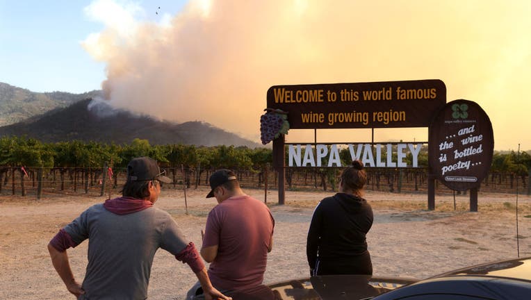
CALISTOGA, CALIFORNIA - SEPTEMBER 27: Residents look on as the Glass Fire burns through the area on September 27, 2020 in Calistoga, California. The fast moving Glass fire has burned over 1,000 acres and has destroyed homes. Much of Northern Californ
ST. HELENA, Calif. - As of October 9, the Glass Fire burned 67,484 acres and is 74% contained, according to Cal Fire.
The wildfire broke out September 27 in Napa County and quickly expanded into Sonoma County forcing thousands of residents to evacuate.
So far, the flames have destroyed 1,545 structures and damaged 280 others, Cal Fire said.
Here are the latest evacuation orders, evacuation warnings, and evacuation centers for the wildfires burning in the North Bay.
Click here for Napa County road closures
NAPA COUNTY UPDATE (10/9):
Highway 29:
The following areas have had their Evacuation Order reduced to Evacuation Warning:
Highway 29 is open for traffic in both directions from Tubbs Lane to the Lake County line.
All addresses west of Highway 29 between northern city limit of St. Helena and the southern city limits of Calistoga, except Diamond Mountain Road and Bothe State Park
All addresses east of Highway 29 between northern city limit of Calistoga and Tubbs Lane
All addresses on both sides of Highway 29 between Tubbs Lane and the Lake County line, except for addresses on the east side of Highway 29, north of the Robert Louis Stevenson trailhead parking area.
Addresses on Old Lawley Toll Rd. lower than 3500 Block and greater than 3700. Due to hazardous road conditions, Old Lawley Toll Rd is closed between the 3500 Block and 3700 Block.
The following areas have had their Evacuation Warning lifted:
All areas on the valley floor north of the City Limits of Calistoga to the Sonoma County line, to include the areas of Tubbs Lane, Bennett Lane, Myrtledale Rd.
All areas of Napa County to the west of Highway 29/128 and north of Diamond Mountain Road.
Silverado Trail:
The following areas have had their Evacuation Order reduced to Evacuation Warning:
Silverado Trail is open for traffic in both directions.
All addresses on the east side of Silverado Trail north of Deer Park Road, except for addresses accessed by way of Glass Mountain Road and Crystal Springs Road.
Deer Park Road remains closed between Silverado Trail and South White Cottage Road (4 Corners)
Glass Mountain Road and Crystal Springs Road remain closed east of Silverado Trail.
Aetna Springs Area:
The following areas have had their Evacuation Order reduced to Evacuation Warning:
The geographic area of rural Northern Napa County between Highway 29 and Pope Valley road, north of the end of North Fork Crystal Springs Road and south of Aetna Springs Road.
All trails and recreation areas in the Robert Louis Stevenson park system remain closed.
The following areas have had their Evacuation Warning Lifted:
The Aetna Springs area north of Aetna Springs Road to the Lake County line and east of Aetna Mine Rd to Pope Valley Rd/Butts Canyon Rd.
Whitehall Lane / Mt. St. John Area:
The following areas have had their Evacuation Warning Lifted:
The area west of the end of Whitehall Lane to the Sonoma County line and south of the city limits of St. Helena.
The following road closures remain in effect:
The Deer Park neighborhood remains closed, including road closures at:
Deer Park Road at Silverado Trail
Deer Park Road at Howell Mountain
Glass Mountain Road at Silverado Trail
Crystal Springs Road at Silverado Trail
Road closures on the west side of the valley:
Diamond Mountain Road at Highway 29
Spring Mountain Road at St Helena City Limits
White Sulphur Springs Road at St Helena City Limits
All other orders and warnings remain in place
Napa County Evacuation Orders:
- All areas of Napa County north of Calistoga City limits between Highway 128, Sonoma County line and Highway 29
- All addresses on both sides of Highway 29 between Calistoga City limits and Lake County line
- All addresses on Old Lawley Toll Road
- Whitehall Lane to Bella Aks Area
- South of Chiles Pope Valley Road
- East of Ink Grade Road
- West of Pope Valley Cross Road
- Entire city of Calistoga
- East side of Silverado Trail between Taplin Road and Sage Canyon Road and Sage Canyon Road east to Chiles Pope Valley Road
- North of Bothe State Park to Diamond Mountain Road.
- Highway 29 is closed to through traffic between Lincoln Ave and Deer Park Road
- East of Howell Mountain Road from Crestmont Drive to Cold Springs Road, including Las Posadas Road and Linda Falls Terrace. Evacuate via Pope Valley. Do not attempt to evacuate via Deer Park Road.
- The area bordered by Spring Mountain Road, Madrona Road, Spring Street and White Sulpher Springs Road
- East of Silverado Trail from Pickett Lane to Palisades Road to the end of Palisades Road
- The unincorporated area from the 2900 block of White Sulpher Springs Road (St. Helena City Limits) to the dead end and north to Spring Mountain Road
- From 1650 South Whitehall Lane north to White Sulpher Springs Road and west to the County line
- West of Highway 29 from Deer Park Road to Elmhurst, and all of Spring Mountain Road
- Eastside of Silverado Trail from Lommel Road to Pickett Road
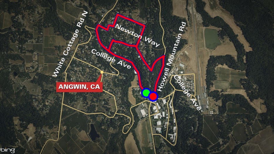
- College Avenue at Howell Mountain Road to White Cottage Road and all of Freisen Drive, including all roads west of College Avenue and Freisen Drive
- All of Lommel Road
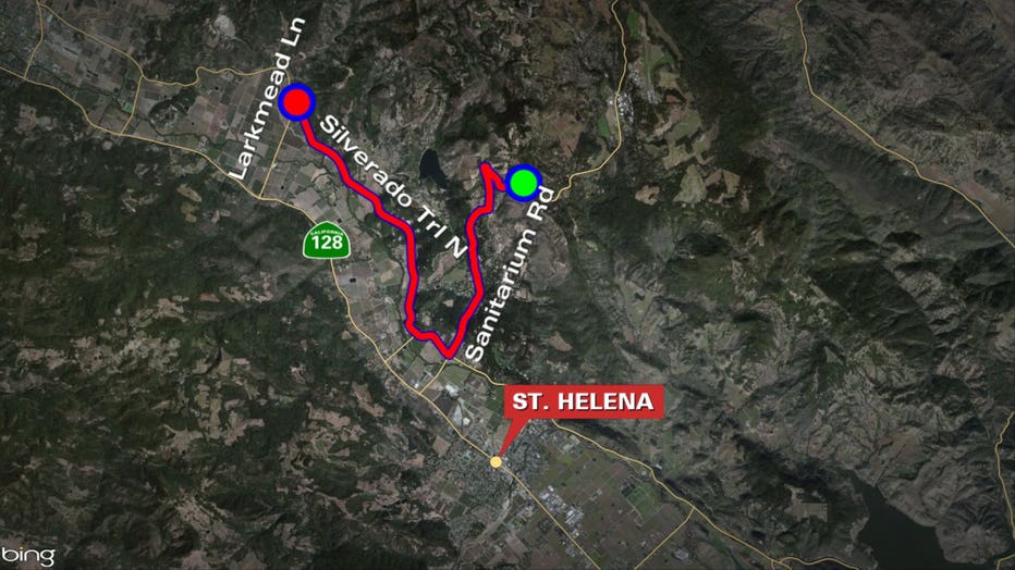
- Eastside of Silverado Trail from Larkmead Road to Deer Park Road. This includes both sides of Deer Park Road up to Crestmont Drive including Sanitarium Road
- The community of Deer Park
Sonoma County Evacuation Orders:
- Pythian
- Oakmont North
- Oakmont South
- Stonebridge
- Calistoga - North
- Calistoga -South/ Skyhawk zone for the following areas within the zone: East of San Ramon East and South of Mountain Hawk Drive between Highway 12 and San Ramon Drive
- East of San Ramon
- East and South of Mountain Hawk Drive between Highway 12 and San Ramon Drive
- Melita for the following areas within the zone: East of Calistoga Road North of Melita Road between Queen Ann Drive and Montgomery Drive All areas east of Channel Drive and south of Montgomery Drive
- East of Calistoga Road
- North of Melita Road between Queen Ann Drive and Montgomery Drive
- All areas east of Channel Drive and south of Montgomery Drive
- Zone 3Q1 – All of Annadel State Park
- Zone Northeast 2 –East of Brush Creek Rd; North of Montecito Blvd; West of Calistoga Rd; South of City Boundary (north of Badger Rd area)
- Zone 2P1 – South of Porter Creek Road; East of Mark West Springs Road; North of Santa Rosa City Limits; West of Calistoga Road
- Zone 6B1 – South and west of the Napa/Sonoma County Line; Northeast of Highway 12 and north of the southernmost boundary of Sugarloaf Ridge State Park; Northwest of Adobe Canyon Road; East of Pythian Road and Hood Mountain Regional Park.
- Zone 6B2 – Northeast of Highway 12; Northwest of Nelligan Road/Nuns Canyon Road; West of the Napa/Sonoma County line; Southeast of Adobe Canyon Road and south of Sugarloaf Ridge State Park.
- Zone 3G2 – South of Cleland Ranch Road; West of Los Alamos Road; North and east of Santa Rosa City Limits; East of Calistoga Road;
- Zone 3G3 – South of Los Alamos Road; West of Santa Rosa City Limits and Los Alamos Road; Northeast of Highway 12; West of the Napa/Sonoma County Line, the easternmost boundary of Hood Mountain Regional Park, and easternmost boundary of Los Guilicos Juvenile Center. This includes Los Guilicos Juvenile Center.
- Zone 3G1 –South of St. Helena Road; West of the Napa/Sonoma County line; North of Los Alamos / Cleland Ranch Roads; and East of Calistoga Road.

A CalFire airplane drops fire retardant over the Davis Winery during the Glass fire in Napa County's St. Helena, California on September 27, 2020. - Napa County between Calistoga and St. Helena overnight on September 27, 2020 just as the Bay Area bra
Napa County Evacuation Warnings
- All addresses west of Pope Valley Road/Chiles Pope Valley Road between Ink Grade Road and Highway 128.
- All addresses in the community of Angwin except addresses on Crestmont Drive and Ink Grade Road.
- All addresses in the area of Conn Valley Road, south of Old Howell Mountain Road, including all addresses in the area of: Conn Valley Road, Rossi Road, Greenfield Road and Greenfield Way
- Within the city of St. Helena from Elmhurst Avenue to Madrona Ave west of Highway 29 to the St. Helena city limits.
- East of Silverado Trail between Taplin Road and Sage Canyon Road east to Chiles Pope Valley Road.
- West of Highway 29 to Petrified Forest Road to the county line
- All areas between Silverado Trail and Highway 29 from Larkmead Lane to Zinfandel Lane, including areas within the city of Saint Helena
- All areas West of Highway 29 from Whitehall Lane to Madrona Avenue including the areas within the city of Saint Helena
Sonoma County Evacuation Warnings:
- Evacuation Orders are being reduced to Evacuation Warnings outside of the burn area for the following zones:
- •Calistoga –North
- Calistoga –South / Skyhawk
- Melita
- Pythian (City of Santa Rosa addresses accessed offLos Alamos Rd) NOTE: Burned areas within these zones will remain under an Evacuation Order.
- Summerfield zone
- Spring Lake ozne
- Northeast 1 zone
- Northeast 3/Middle Rincon zone – East of Mission Blvd; North of Highway 12; South of Montecito Blvd; West of Calistog Rd
- Calistoga - South/ Skyhawk zone for the following areas within the zone: West and north Mountain Hawk Road between Highway 12 and San Ramon Way West of San Ramon Way
- West and north Mountain Hawk Road between Highway 12 and San Ramon Way
- West of San Ramon Way
- Melita for the following areas within the zone West of Calistoga Road South of Melita, North of Montgomery Drive and all homes accessible via Violette
- West of Calistoga Road
- South of Melita, North of Montgomery Drive and all homes accessible via Violette
- Mission and Montgomery Dr between Highway 12 and Summerfield Rd (Santa Rosa)
An evacuation warning means properties should prepare to evacuate if ordered. Anyone that may have difficulty evacuating quickly, should consider evacuating as a precaution.
Click here for Sonoma County road closures
Evacuation Centers:
Napa County Evacuation Center
- Cross Walk Church: 2590 First Street, Napa, CA
Sonoma County Evacuation Centers
- A Place to Play (Temporary Evacuation Point) 2375 West 3rd Street
- Sonoma-Marin Fairgrounds, 175 Fairgrounds Drive -- shelter is full as of 10:30 a.m Monday, but they have parking on their carnival lawn and the main parking lot. RVs are welcome to use our overflow parking lot, Lot B. Track latest updates here.
- Petaluma Veteran’s Building (Temporary Evacuation Point and shelter) 1094 Petaluma Blvd. South -- this evacuation center is at capacity as of Monday at 10:30 a.m., track latest updates here
- Sonoma Raceway (50-acre campground open for tent and RV camping) 29355 Arnold Dr.
Individuals who are seeking shelter are reminded to bring a face covering, practice good hygiene habits, and adhere to physical distancing.
Evacuations shelters have been set up to provide assistance with animals that are in danger.
Animal evacuation shelters
Horses should be brought to:
Sonoma Horse Park
7600 Lakeville Hwy
Petaluma, CA 94954
(415) 518-2145
Smaller animalscan be brought to:
Sonoma-Marin Fair
175 Fairgrounds Drive,
Petaluma, CA 94952
Check the air quality near you on KTVU's air quality map
Download KTVU's free news and weather apps
Map of evacuation orders in the Glass Fire, as of Sunday, September 27, 2020 at 12 p.m.
Map of evacuation orders in the Glass Fire, as of Sunday, September 27, 2020 at 12 p.m.