


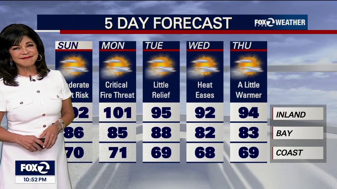
Critical Fire Danger
Saturday Night Update! • The Threat: A near-critical fire weather threat is active through Monday across the interior North Bay, East Bay, Diablo Range and Santa Lucia Range.. • Nocturnal Wind Blast: A cold front will trigger a weak offshore wind push across the North Bay and Central Coast tonight, which could drag warm, bone-dry ridge air all the way down to the beaches. Mixes out marine layer except for a patch near Half Moon Bay and Santa Cruz. • The Sunday Night Peak: An even stronger, deeper pulse of dry offshore downslope winds is forecast to slam the Bay Area and North Bay ridges from Sunday night into Monday morning. While wind speeds will stay just below official Wind Advisory criteria, these nocturnal winds will cause severe humidity drops, keeping mountain fire behavior aggressively active overnight. . • Temps inland up to and over 100 degrees through Monday!
Saturday Night Update! • The Threat: A near-critical fire weather threat is active through Monday across the interior North Bay, East Bay, Diablo Range and Santa Lucia Range.. • Nocturnal Wind Blast: A cold front will trigger a weak offshore wind push across the North Bay and Central Coast tonight, which could drag warm, bone-dry ridge air all the way down to the beaches. Mixes out marine layer except for a patch near Half Moon Bay and Santa Cruz. • The Sunday Night Peak: An even stronger, deeper pulse of dry offshore downslope winds is forecast to slam the Bay Area and North Bay ridges from Sunday night into Monday morning. While wind speeds will stay just below official Wind Advisory criteria, these nocturnal winds will cause severe humidity drops, keeping mountain fire behavior aggressively active overnight. . • Temps inland up to and over 100 degrees through Monday!
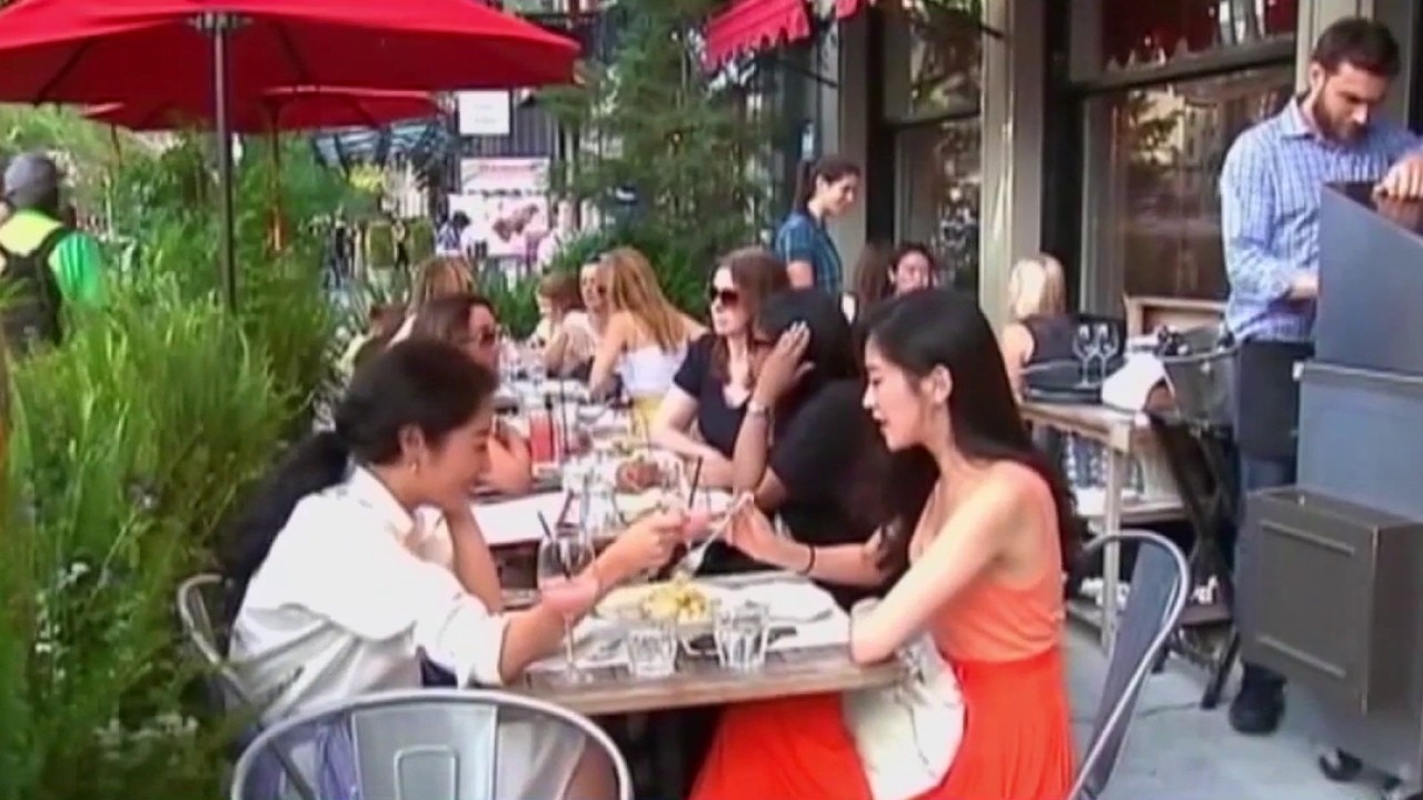
Navigating adult friendships
Licensed clinical psychologist, Dr. Jessica Hamilton, joins us to discuss why many adults struggle to make and maintain friendships, and how to build stronger social connections.
Licensed clinical psychologist, Dr. Jessica Hamilton, joins us to discuss why many adults struggle to make and maintain friendships, and how to build stronger social connections.

Beyond fitness: How exercise benefits the brain
Scientists keep finding new evidence that exercise directly impacts brain health. While physical benefits like better cardiovascular health and lower blood sugar are well known, what about our mental health? Rio Wilson, founder of Brain Body Therapy, joins Mornings on 2 to explain the powerful brain-body connection.
Scientists keep finding new evidence that exercise directly impacts brain health. While physical benefits like better cardiovascular health and lower blood sugar are well known, what about our mental health? Rio Wilson, founder of Brain Body Therapy, joins Mornings on 2 to explain the powerful brain-body connection.
Local nonprofit helps prevent teacher burnout
As the new school year approaches, teacher burnout remains a growing challenge nationwide. Lindsey Fuller, executive director of the local nonprofit The Teaching Well, joins us to discuss how schools can better support educators' mental health, improve teacher retention, and help prevent burnout before it starts.
As the new school year approaches, teacher burnout remains a growing challenge nationwide. Lindsey Fuller, executive director of the local nonprofit The Teaching Well, joins us to discuss how schools can better support educators' mental health, improve teacher retention, and help prevent burnout before it starts.

Love in Action Day: Free backpacks, food, so much for the Vallejo community
The directors of 'Love in Action Day' join us in studio to talk about Sunday's event, aimed at helping hundreds of community members get ready for back-to-school season. Whether it's a free backpack and haircut, or brand-new clothes and a free grocery bag, there is so much available for anyone in need.
The directors of 'Love in Action Day' join us in studio to talk about Sunday's event, aimed at helping hundreds of community members get ready for back-to-school season. Whether it's a free backpack and haircut, or brand-new clothes and a free grocery bag, there is so much available for anyone in need.

Beyond the 'divorce glow up'
A relationship expert explains the science behind the viral 'divorce effect' trend single influencers can't stop talking about.
A relationship expert explains the science behind the viral 'divorce effect' trend single influencers can't stop talking about.

Heat, haze, hazardous surf
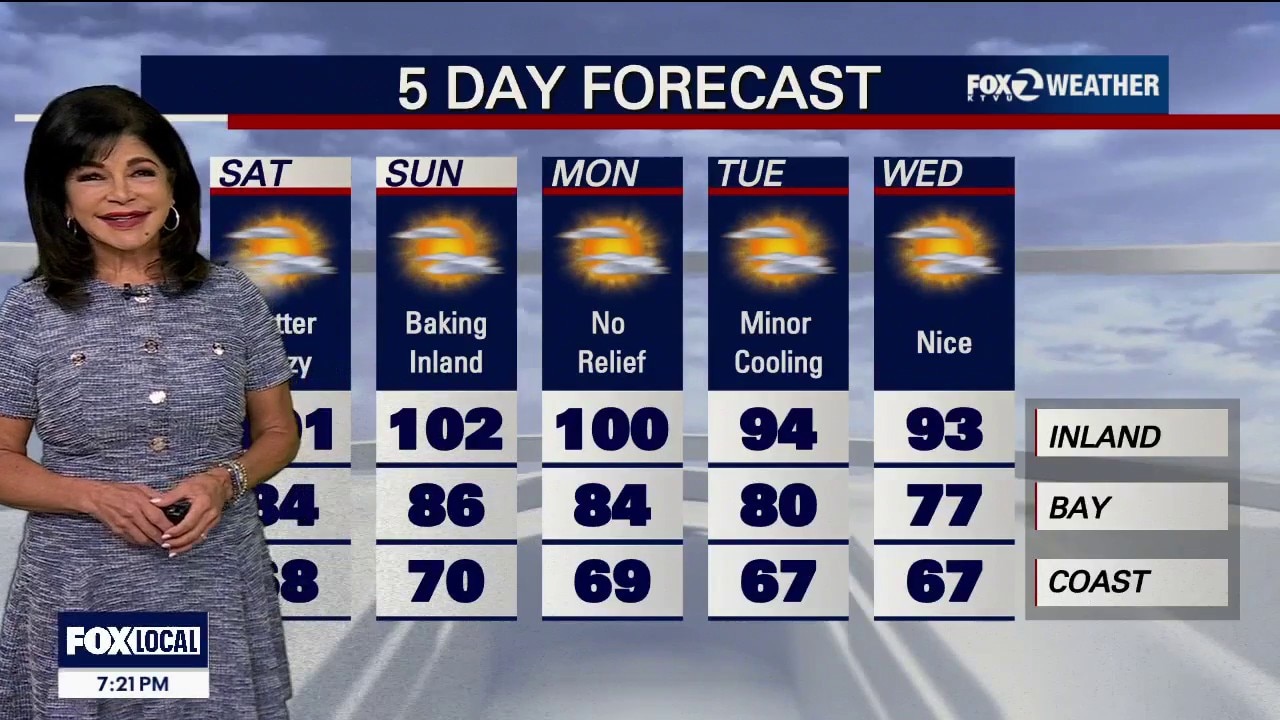
Hazy skies continue across the Bay Area today as smoke from a nearby wildfire creates reduced air quality, especially across the North Bay. A Spare the Air Alert is in place for the entire Bay Area. The weather pattern is turning hotter and drier this weekend as high pressure strengthens over California. Inland communities will see the biggest warm-up, with afternoon temperatures climbing into the upper 90s, while bayside locations remain warm and the coast stays noticeably cooler. If you're planning to head to the beach to escape the heat, use extra caution. A Beach Hazards Statement remains in effect until 5:00 p.m. Long-period swells are creating dangerous rip currents and the potential for sneaker waves that can unexpectedly rush much farther up the beach than normal.
Hazy skies continue across the Bay Area today as smoke from a nearby wildfire creates reduced air quality, especially across the North Bay. A Spare the Air Alert is in place for the entire Bay Area. The weather pattern is turning hotter and drier this weekend as high pressure strengthens over California. Inland communities will see the biggest warm-up, with afternoon temperatures climbing into the upper 90s, while bayside locations remain warm and the coast stays noticeably cooler. If you're planning to head to the beach to escape the heat, use extra caution. A Beach Hazards Statement remains in effect until 5:00 p.m. Long-period swells are creating dangerous rip currents and the potential for sneaker waves that can unexpectedly rush much farther up the beach than normal.
Smoke, Sunshine, and Soaring Temperatures
Hazy skies continue across the Bay Area today as smoke from a nearby wildfire creates reduced air quality, especially across the North Bay. A Spare the Air Alert is in place for the entire Bay Area. The weather pattern is turning hotter and drier this weekend as high pressure strengthens over California. Inland communities will see the biggest warm-up, with afternoon temperatures climbing into the upper 90s, while bayside locations remain warm and the coast stays noticeably cooler. If you're planning to head to the beach to escape the heat, use extra caution. A Beach Hazards Statement remains in effect until 5:00 p.m. Long-period swells are creating dangerous rip currents and the potential for sneaker waves that can unexpectedly rush much farther up the beach than normal.
Hazy skies continue across the Bay Area today as smoke from a nearby wildfire creates reduced air quality, especially across the North Bay. A Spare the Air Alert is in place for the entire Bay Area. The weather pattern is turning hotter and drier this weekend as high pressure strengthens over California. Inland communities will see the biggest warm-up, with afternoon temperatures climbing into the upper 90s, while bayside locations remain warm and the coast stays noticeably cooler. If you're planning to head to the beach to escape the heat, use extra caution. A Beach Hazards Statement remains in effect until 5:00 p.m. Long-period swells are creating dangerous rip currents and the potential for sneaker waves that can unexpectedly rush much farther up the beach than normal.
August is coming in hot
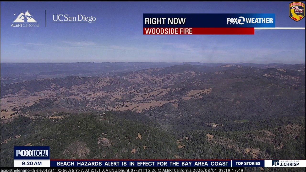
Woodside Fire Smoke The Smoke Path: High-resolution tracking shows heavy smoke from the Woodside Fire pushing into the Sonoma County valleys and across the North Bay. Blasting northwest winds of 25 to 30 mph are hitting the active wildfire site this evening, pushing the smoke parallel to the Sonoma coast before dragging it straight through the Petaluma Gap and dumping it into the inland valleys. If you live in northern and western Sonoma County you should monitor the Northern Sonoma County Air Pollution Control District, while the rest of the Bay Area should track the Bay Area Air Quality Management District for real-time air quality closures and particulate safety. Saturday Heat Wave Peak The Sizzle: High pressure over the Desert Southwest is compressing the marine layer and forcing temperatures well above averages. Highs will tick a few degrees hotter tomorrow. Expect mid-60s at the beaches, comfortable mid-70s to low 80s around the Bays, and roasting 90s to 104°F across the inland valleys.
Woodside Fire Smoke The Smoke Path: High-resolution tracking shows heavy smoke from the Woodside Fire pushing into the Sonoma County valleys and across the North Bay. Blasting northwest winds of 25 to 30 mph are hitting the active wildfire site this evening, pushing the smoke parallel to the Sonoma coast before dragging it straight through the Petaluma Gap and dumping it into the inland valleys. If you live in northern and western Sonoma County you should monitor the Northern Sonoma County Air Pollution Control District, while the rest of the Bay Area should track the Bay Area Air Quality Management District for real-time air quality closures and particulate safety. Saturday Heat Wave Peak The Sizzle: High pressure over the Desert Southwest is compressing the marine layer and forcing temperatures well above averages. Highs will tick a few degrees hotter tomorrow. Expect mid-60s at the beaches, comfortable mid-70s to low 80s around the Bays, and roasting 90s to 104°F across the inland valleys.

DACA renewal delays leaving immigrants in limbo
Every two years, DACA recipients must renew their protected status. But many say applications that once took weeks are now taking months, leaving recipients vulnerable to losing their jobs, driver’s licenses, and temporary legal protections before new approvals arrive. Luis Cortes Romero, immigration attorney at Novo Legal Group, gives insight.
Every two years, DACA recipients must renew their protected status. But many say applications that once took weeks are now taking months, leaving recipients vulnerable to losing their jobs, driver’s licenses, and temporary legal protections before new approvals arrive. Luis Cortes Romero, immigration attorney at Novo Legal Group, gives insight.
Sudden hearing loss warnings
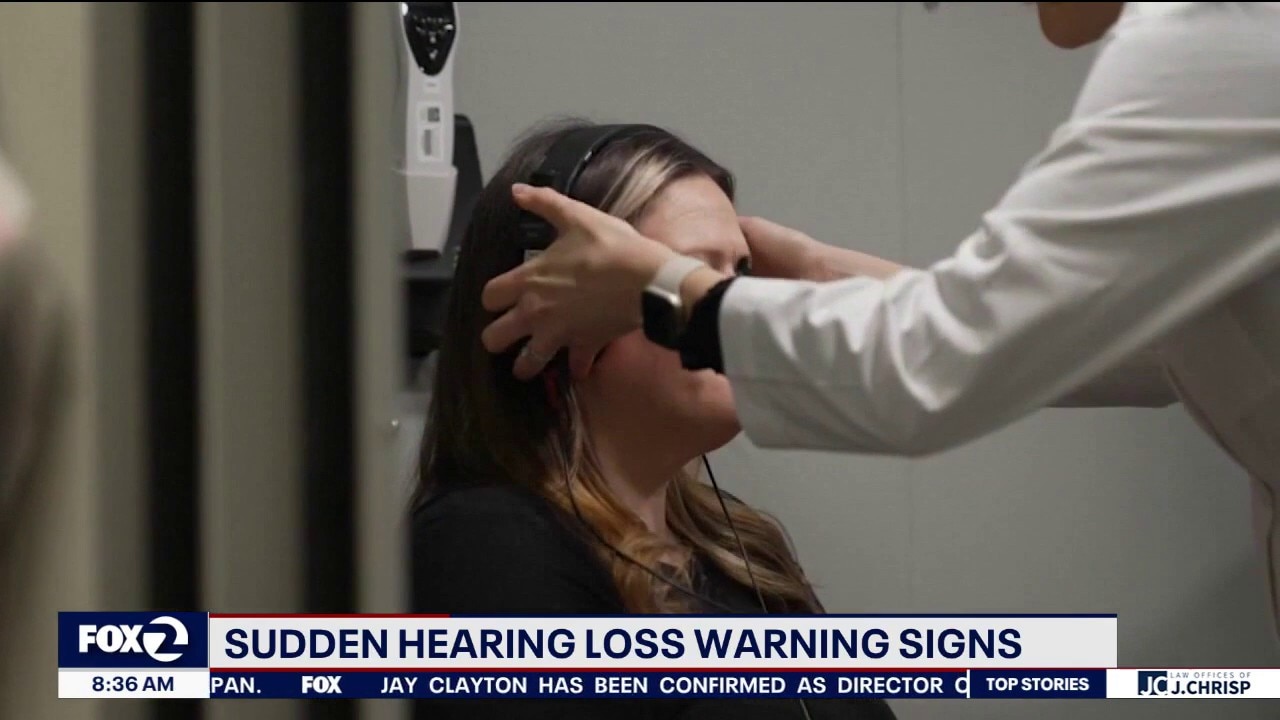
When it comes to sudden hearing loss, time is critical. Specialists say treatment within the first week and ideally much sooner offers the best chance of restoring hearing. Dr. Donald McGillivray, an audiologist at Kaiser Permanente Santa Rosa, gives insight.
When it comes to sudden hearing loss, time is critical. Specialists say treatment within the first week and ideally much sooner offers the best chance of restoring hearing. Dr. Donald McGillivray, an audiologist at Kaiser Permanente Santa Rosa, gives insight.


Ghirardelli chocolate workers in San Francisco walk off job for 3-day strike
Workers at The Original Ghirardelli Chocolate & Ice Cream Shop in San Francisco walked off the job on Thursday for a three-day strike. They are asking customers to boycott the store at a popular tourist area.
Workers at The Original Ghirardelli Chocolate & Ice Cream Shop in San Francisco walked off the job on Thursday for a three-day strike. They are asking customers to boycott the store at a popular tourist area.
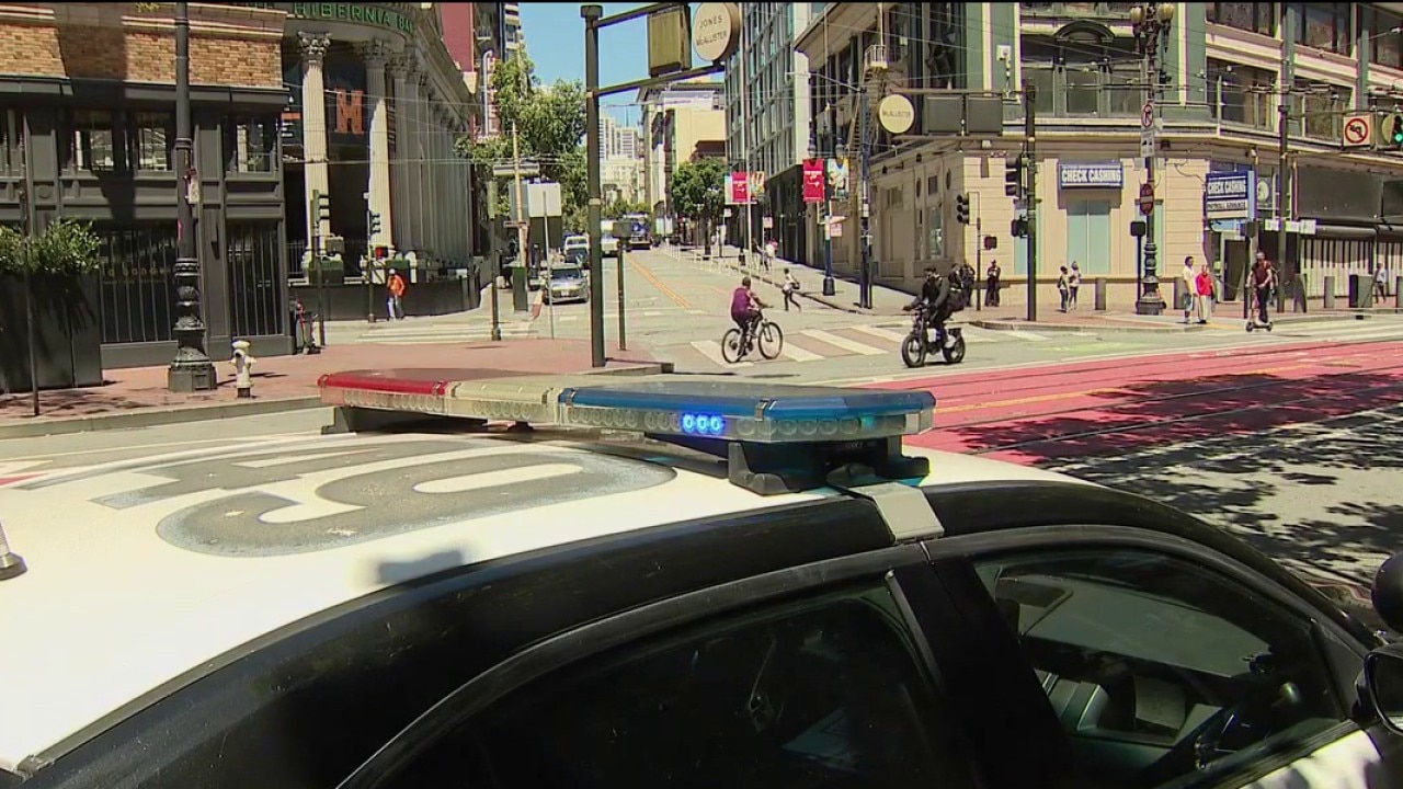
San Francisco police to step up patrols around Market Street after shootings
The increased security measures come as police acknowledge that some residents and business owners feel unsafe in the area. Officers are expected to patrol 24 hours a day along Market Street from 5th Street to Van Ness Avenue.
The increased security measures come as police acknowledge that some residents and business owners feel unsafe in the area. Officers are expected to patrol 24 hours a day along Market Street from 5th Street to Van Ness Avenue.

There's a whole lot of weather going on
Today & Friday: Highs lower-to-middle 60s at the coast, 70s to lower 80s around the Bays, and 90s in the valleys. Saturday through Monday: Moderate Heat Risk will engulf the entire interior through early next week. 100 to 102 inland. Downtown Oakland & San Francisco will remain shielded from the worst of the heat, mid-70s to lower 80s. An elevated fire weather across the interior North Bay, East Bay, Diablo Range and Santa Lucia Range through next week. Sunday Night Wind: Dry offshore wind gusts is forecast across the North Bay & SF Bay regions. The Marine Engine: Advanced weather modeling is flashing POTENTIALLY HISTORIC winds over the ocean this weekend. Storm-force gusts exceeding 60 mph across the northern waters off the Sonoma and Marin county coastlines. (Late Saturday). Beach Hazards Statement (through Saturday 5 PM) in effect across all local Pacific beaches. The Risk: Long-period southerly ocean swells are generating massive, deceptive sneaker waves and intense rip currents.
Today & Friday: Highs lower-to-middle 60s at the coast, 70s to lower 80s around the Bays, and 90s in the valleys. Saturday through Monday: Moderate Heat Risk will engulf the entire interior through early next week. 100 to 102 inland. Downtown Oakland & San Francisco will remain shielded from the worst of the heat, mid-70s to lower 80s. An elevated fire weather across the interior North Bay, East Bay, Diablo Range and Santa Lucia Range through next week. Sunday Night Wind: Dry offshore wind gusts is forecast across the North Bay & SF Bay regions. The Marine Engine: Advanced weather modeling is flashing POTENTIALLY HISTORIC winds over the ocean this weekend. Storm-force gusts exceeding 60 mph across the northern waters off the Sonoma and Marin county coastlines. (Late Saturday). Beach Hazards Statement (through Saturday 5 PM) in effect across all local Pacific beaches. The Risk: Long-period southerly ocean swells are generating massive, deceptive sneaker waves and intense rip currents.
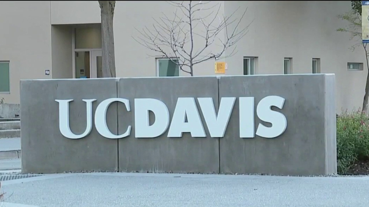
UC System Accepts Record Number of California Residents
UC Davis Vice Provost Malisa Lee joins Mornings on 2 to break down the trends in admissions, and what high school seniors applying for college should know.
UC Davis Vice Provost Malisa Lee joins Mornings on 2 to break down the trends in admissions, and what high school seniors applying for college should know.
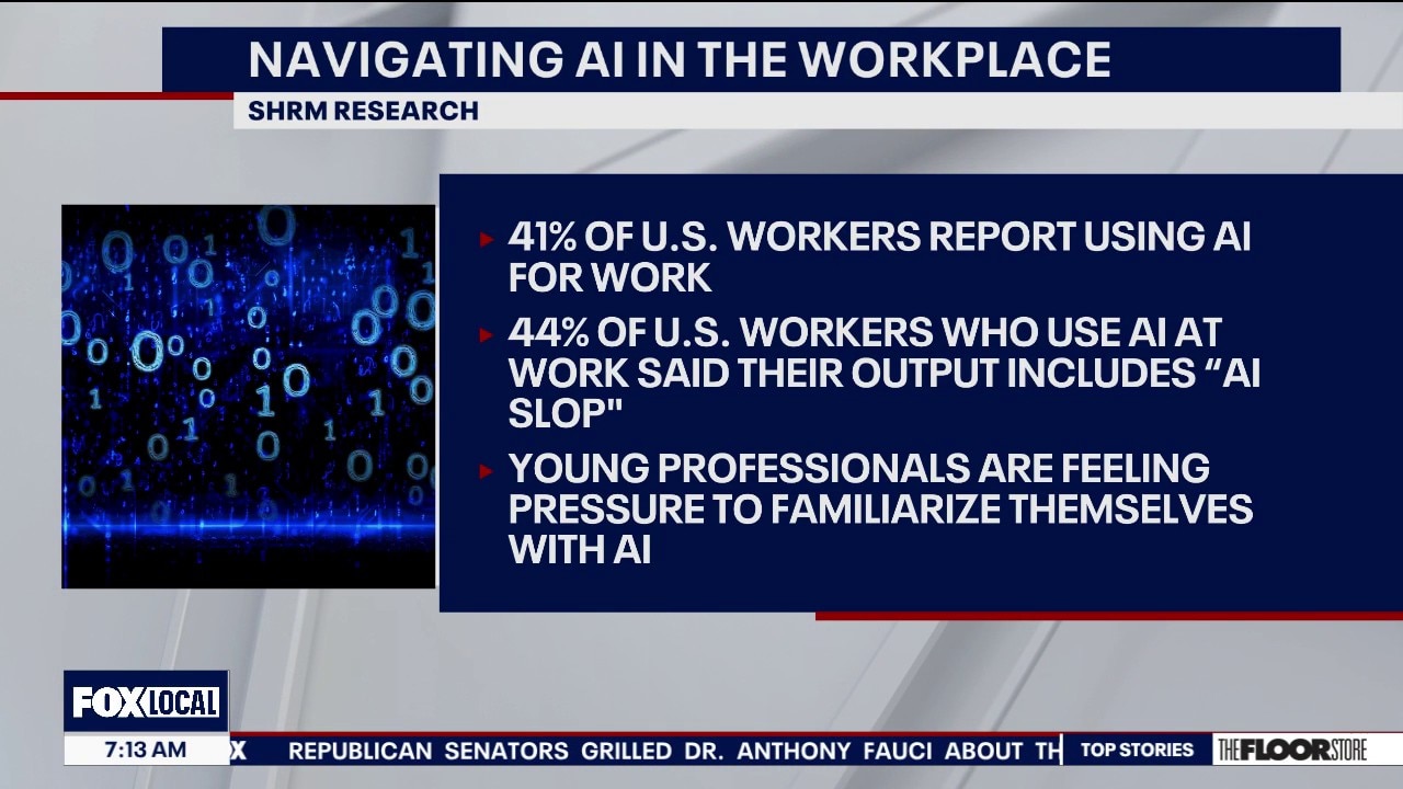
As AI changes how we work, new research reveals how AI impacts productivity and job satisfaction
A live discussion with SHRM leaders discussing their new report exploring how U.S. workers are integrating generative AI into their daily routines—and which industries, roles, and demographics are adopting it the fastest.
A live discussion with SHRM leaders discussing their new report exploring how U.S. workers are integrating generative AI into their daily routines—and which industries, roles, and demographics are adopting it the fastest.

Federal Reserve Leaves Interest Rates Unchanged
The federal reserve left its key interest rate unchanged at its meeting yesterday. But some members of the federal reserve board appeared in favor of raising rates in the face of inflation, despite the president's push for the fed to cut rates. Financial advisor Jason Matthews joins Mornings on 2 to discuss what it means for consumers.
The federal reserve left its key interest rate unchanged at its meeting yesterday. But some members of the federal reserve board appeared in favor of raising rates in the face of inflation, despite the president's push for the fed to cut rates. Financial advisor Jason Matthews joins Mornings on 2 to discuss what it means for consumers.
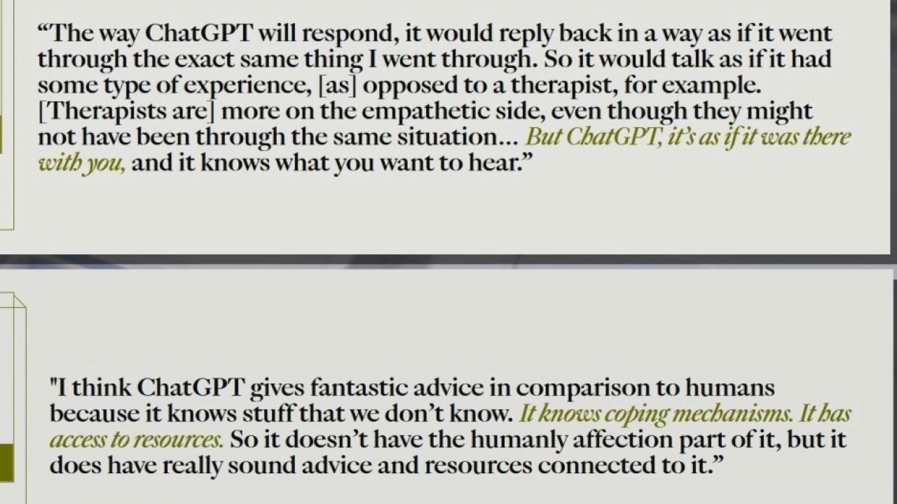
Why more young adults are turning to AI for emotional support
As a growing number of young people turn to AI for emotional support, new research from Hopelab and the Center for Digitial Thriving reveals some of the reasons young adults are turn to AI chatbots, before turning to a friend, family, or professional for connection.
As a growing number of young people turn to AI for emotional support, new research from Hopelab and the Center for Digitial Thriving reveals some of the reasons young adults are turn to AI chatbots, before turning to a friend, family, or professional for connection.


San Francisco police to step up Mid-Market patrols after shootings
San Francisco police plan to maintain an increased presence in the mid-Market neighborhood for at least the next week following three separate shootings earlier this week within a two-block radius of Market Street.
San Francisco police plan to maintain an increased presence in the mid-Market neighborhood for at least the next week following three separate shootings earlier this week within a two-block radius of Market Street.
Transgender, South Asian-led immigrant nonprofit, faces potential closure
A vital San Francisco nonprofit that supports transgender immigrants says it has lost nearly all of its critical funding and may soon be forced to shut its doors.
A vital San Francisco nonprofit that supports transgender immigrants says it has lost nearly all of its critical funding and may soon be forced to shut its doors.