

LNU Lightning Complex: Wildfire destroys homes in Vacaville, scorches more acres

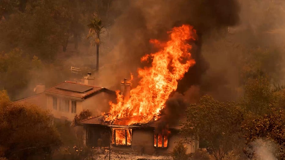
VACAVILLE, Calif. - The fires raging across five counties in the North Bay grew to 215,000 acres by Thursday evening, destroyed more than 100 homes including some in Vacaville and killed a PG&E utility worker assisting with the firefighting efforts.
480 structures have been destroyed, Cal Fire said, while more than 30,500 structures remain threatened.
Early in the morning, KTVU cameras drove along English Hills Road, where homes once stood.
Known as the LNU Lightning Complex Fire, the biggest blaze of the group is the Hennessey Fire burning in Napa County. That particular fire has burned 105,000 acres and is 0% contained, according to Cal Fire.
The other fires in the complex are burning in Solano, Napa, Sonoma, Yolo and Lake counties.
Crews in Solano County discovered the body of an unidentified man on Pleasants Valley Road, near Vacaville, Solano County Sheriff's Office said Thursday evening. Officials are trying to notify next of kin and will have more details soon. Cal Fire officials said four civillians in all have died.
"The bottom side of this fire and the top side of this fire are going to combine and this blue ridge will all be all interior, the blue ridge is gonna go ahead and burn again," said a Cal Fire operations officer.

Dozens of homes burn in Vacaville
Dozens of homes burn because of LNU Lightning Complex Fire. Elissa Harrington reports
Many residents were forced to evacuate on Wednesday when flames jumped Interstate 80 Vacaville and Fairfield, prompting the California Highway Patrol to close a stretch of the roach.
Some drivers were stuck in gridlock traffic, worried about their safety.
Firefighters know that many residents have experienced fire danger or even tragedy in recent years but they stress it’s important to be ready.
"Make that decision to leave your home," said Cal Fire incident commander Sean Kavanaugh. "The last thing we want is for people to be trapped in their homes and not be able to get out."
Fire officials on Thursday said that they are hoping weather conditions return to a normal pattern with a coastal influence which would help with the firefight on the ground.
While more firefighters are on the way, mutual aid from many law enforcement agencies are already on site with more coming.
"Our police response is there to assist with evacuation, to keep evacuation areas clear so that fore apparatus and personnel can fight fires and to insure the safety of property once people have evacuated," said Sonoma County Sheriff Mark Essick.
So, said Napa Lake Unit Chief Shauna Jones, be prepared for the long haul. "It's gonna take time. This is very large fire. This is one of many in California," said Jones.
In other words, so long as this goes on, entering the evacuation areas is both illegal and dangerous because of all the debris, downed power lines as well as downed or weakened trees.
August 19, 2020, Vacaville, CA, USA: A home does up in flames on Serenity Hills road during the LNU Lightning Complex fires at the on Wednesday, Aug 19, 2020 in Vacaville. .It is a rapidly spreading wildfire that spread towards Vacaville early Wednes
The latest statistics on the other fires in the group:
Napa and Lake County:
Aetna Fire: The fire is currently 4,500 acres and 0% contained.
Sonoma County:
Walbridge Fire: West of Healdsburg. The fire is currently 14,500 acres and 0% contained.
Meyers Fire: North of Jenner. The fire is currently 3,000 acres and 0% contained.
Lake County:
Round Fire - The fire is currently 4,000 acres and 0% contained.
HERE ARE THE EVACUATION ORDERS:
Napa County:
- Highway 128 from Lower Chiles Valley Road to Monticello Road
- Highway 128 from Chiles Pope Valley Road to Lower Chiles Valley Road
- Chiles Pope Valley Road from Highway 128 to Lower Chiles Valley Road
- All of Hennessey Ridge Road.
- From Moskowite Corner to Wooden Valley Rd, Including the community of Circle Oaks
- Atlas Peak from the Bubbing Well Pet Cemetary at 2462 Atlas Peak Rd to the dead end
- From Loma Vista Rd / Soda Canyon Rd to the dead end.
- All of Steele Canyon Rd from Hwy 128 to and including the Berryessa Highlands Sub Divison
- Wragg Canyon Rd - from Hwy 128 to the end of the road, including Pleasure Cove Resort
- Chiles Pope Valley Road - From Lower Chiles Valley Road to Pope Canyon Road
- Highway 121 (Monticello Road) – from Wooden Valley Road to Silveraldo Trail
- Pope Valley Rode – From Aetna Springs Road to Chiles Pope Valley Road
- Aetna Springs Road – From Pope Valley to the dead end
- Butts Canyon Road – From Aetna Springs Road to the Lake County Line
- James Creek Road – From Butts Canyon Road to the dead end
- Highway 121 (Monticello Road) – from Wooden Valley Road to Vichy Ave.
- Community of Angwin
- Community of Deer Park
- St Helena Hospital
- East side of HWY 29 from Lake County line down to Silverado Trail
- East side of Silverado Trail from Highway 29 to Highway 128
- Northwest side of Highway 128 to Chiles Pope Valley Road
- Northwest side of Chiles Pope Valley Road to Pope Valley Road
- Northwest side of Pope Valley Road to Butts Canyon Road
- West side of Butts Canyon to Lake County
Sonoma County:
- North of Austin Creek Recreational Area
- East of The Cedars
- Mill Creek Road west of the intersection of Puccioni Road
- South of Stewarts Point Skaggs Springs Road
- South of Stewarts Point Skaggs Springs Road
- West of West Dry Creek Road and Westside Road
- North of Sweetwater Springs Road and McCray Ridge Road
- East of the East Austin Creek (the actual creek)
- The Evacuation Order on Monticello Road from Vichy Ave to Silverado Trail is now an Evacuation Warning.
- Ink Grade – from Pope Valley Road to White Cottage Road
- Howell Mountain Road – From Pope Valley Road to White Cottage Road
Evacuation Warning:
- West of Meyers Grade Road to the coast
- South of Fort Ross Road
- North of Russian Gulch State Beach
- North of Austin Cree Recreational Area
- East of Cedars
- West of Mill Creek Rd
- South of Stewarts Point-Skaggs Spring Road
EVACUATION ZONES
Meyers Fire - County Evacuation Zone 1F1
- All areas east of Bohemian Hwy.
- North of Graton Rd. and Harrison Grade Rd.
- West of Harrison Grade Rd., Green Valley Rd., and Hwy. 116
- South of the Russian River
Meers Fire - County Evacuation Zone 1F2
- All areas south of the Russian River
- East and North of Hwy. 116 (Pocket Canyon)
- West of Martinelli Rd
Walbridge Fire - County Evacuation Zone 4A1
- All areas East of the Russian River
- North of River Rd.
- West of Trenton Healdsburg Rd. and Eastside Rd.
- South of the area between the western dead end of Windsor River Rd. and the Russian River
Walbridge – Evacuation Zone 4B1 (Northern Forestville)
- All areas south of River Rd. from Martinelli Rd. to Trenton Rd.
- West of Covey Rd.
- North of Front St. / Hwy. 116
- East of Martinelli Rd.
Walbridge – Evacuation Zone 2K2
- All areas south of Hwy. 101
- East of the Russian River to the Windsor Town limits
- North of where Windsor River Rd. dead ends extending west to the Russian River.
Meyers – Evacuation Zone 1E3
- All areas south of the Russian River
- West of Bohemian Hwy.
- North and East of Coleman valley Rd. and Willow Creek Rd.
Meyers – Evacuation Zone 1E1
- All areas south and west of Willow Creek Rd.
- North of Coleman Valley Rd. and Wright Hill Rd.
- East of the California Coastal National Monument (BLM property)
Meyers - Evacuation Zone - 1C1
- All areas east of the Sonoma coast to the south fork of the Gualala River.
- South of Kruse Ranch Rd. and Howser Bridge Rd. to Fort Ross Rd.
Lake County:
Evacuation Order:
The Lake County Sheriff’s Office has issued an EVACUATION ORDER for residents living in and around Hidden Valley Lake and Jerusalem Valley areas of Lake County due to a Wildland Fire. This includes residents living North of Butts Canyon Road, South of Hofacker Ln to Morgan Valley Rd, East of Hwy. 29 and West of the Lake/Napa County line. Residents are advised that there is an IMMEDIATE threat to life and property from a wildfire, and are urged to evacuate. Please leave the area. If you are in need of shelter please proceed to a Temporary Evacuation Point (TEP) that has been setup at the old airstrip off of Hwy. 53 in Clearlake. You are asked to stay in your vehicle and wear masks when you arrive at the TEP. A shelter is being established and you will be directed to the shelter by staff at the TEP.
- Eastside of Highway 29 – North of the Napa/Lake County line up to the Southern Intersection of Highway 29 / St Helena Creek Road (Across from the Twin Pine Casino)
- All of St Helena Creek Road - to the Highway 29 / St Helena Creek Road / Butts Canyon Intersection
- This Evacuation Order does not include the Middletown proper
Additional evacuations are ongoing, more to follow
Evacuation Center:
Napa County:
Crosswalk Community Church
2590 First Street
Napa, CA 94558
Sonoma County:
Santa Rosa Fair Grounds 1350 Bennett Valley Road Santa Rosa, CA 95404
Lake County:
Temporary Evacuation Points: Is setup at the old airstrip off of Hwy 53 in Clearlake
Animal Evacuation Center:
Napa County Animal Shelter
942 Hartle Court
Napa, CA 94559
Road Closures:
Napa County:
- SR-121 at Wooden Valley Rd (this was previously the SR-121 at SR-128 closure). This closure will be staffed by an officer. Circle Oaks is being or will be evacuated
- SR-128 at Pleasent's Valley Rd. Woodland CHP and Caltrans are staffing this closure. No traffic westbound on SR-128 from this intersection. Traffic can move east on SR-128 and south on Pleasent's Valley Rd
- Butts Canyon Rd at Snell Valley Rd. This closure is staffed by a CHP officer. We do not want anyone traveling south on Butts Canyon Rd past this intersection
- SR-128 at Silverado Trail. This closure is staffed by a CHP officer and Caltrans
- Napa County Roads is working on the following closures:
- Atlas Peak Rd at Westgate Drive. No traffic north on Atlas Peak Rd. past Westgate Drive. This section of Atlas Peak is being or will be evacuated
- Soda Canyon Rd at Silverado Trail. Soda Canyon Rd. north of Loma Vista Drive is being or will be evacuated. We do not want any traffic on Soda Canyon Rd north of Loma Vista--it's easier to close it at Silverado Trail
Sonoma County:
- SR-1 @ Fort Ross Road- No traffic on S/B SR-1 and no traffic E/B on Fort Ross Rd
- SR-1 @ Meyers Grade Road- No traffic on N/B SR-1 and no traffic on N/B Meyers Grade Rd
- Fort Ross Road at Seaview Road- No traffic on W/B Fort Ross Rd. and no traffic on E/B Fort Ross Rd
- Myers Grade Road at Fort Ross Road- No traffic on S/B Meyers Grade Rd
- Dry Creek Rd at Dry Creek
- Yoaking Bridge Rd at Dry Creek
- Lyton Springs Rd at Dry Creek
- Westside Rd @ Dry Creek
- Wohler Rd at River Rd
- Odd Fellows Park Rd at Russian River
- Bohemian Hwy at Russian River
- Mosscow Rd at Hwy 116
- Hwy 116 at Hwy 1 (Move Hwy 1 at Myers Grade)
- King Ridge Rd @ Sewell Rd (private Rd with gates)
- Skaggs Spings Rd at Sewell Rd (Anvil Ranch)