


Heat wave continues
The October heat wave will continue. Excessive Heat Warnings are in place through Wednesday night. After a mild start Wednesday morning, temperatures will heat up quickly during the afternoon. Highs should range from the low 80s near the coast to 107 well inland. We will likely have another round of records. The hot pattern begins to release its grip Thursday. Stay safe in the heat! -Mark
The October heat wave will continue. Excessive Heat Warnings are in place through Wednesday night. After a mild start Wednesday morning, temperatures will heat up quickly during the afternoon. Highs should range from the low 80s near the coast to 107 well inland. We will likely have another round of records. The hot pattern begins to release its grip Thursday. Stay safe in the heat! -Mark


Crazy hot inland
Today will be 80s and 90s at the coast and up to 106 inland.
Today will be 80s and 90s at the coast and up to 106 inland.


It's a heatwave
Tuesday should be the hottest day of the week with high temperatures into the low 100's. Temperatures will be slow to cool so 90s and 100's will last through Thursday.
Tuesday should be the hottest day of the week with high temperatures into the low 100's. Temperatures will be slow to cool so 90s and 100's will last through Thursday.


Dangerous heat, temps could reach 107
The Bay Area will see some dangerous heat this week. The hottest day will be Tuesday where some areas could be 107 degrees.
The Bay Area will see some dangerous heat this week. The hottest day will be Tuesday where some areas could be 107 degrees.


Above average temps
Today will be about 15 degrees hotter than normal.
Today will be about 15 degrees hotter than normal.


Heat returns early next week
No big changes in your Sunday forecast. Low clouds and fog will hover near the coast and bay during the morning. Mostly sunny skies are expected by the afternoon. Highs should range from the low 60s near the coast to the upper 80s inland. HOT temperatures return early next week (Beaches: 80s, Bay: 90s, Inland: 100+). The hottest day should be Tuesday, Heat Advisories will likely be posted. This dry, hot pattern will also increase the fire danger.
No big changes in your Sunday forecast. Low clouds and fog will hover near the coast and bay during the morning. Mostly sunny skies are expected by the afternoon. Highs should range from the low 60s near the coast to the upper 80s inland. HOT temperatures return early next week (Beaches: 80s, Bay: 90s, Inland: 100+). The hottest day should be Tuesday, Heat Advisories will likely be posted. This dry, hot pattern will also increase the fire danger.


A break from the heat this weekend
Temperatures should cool a bit in your weekend forecast! Low clouds will resurface near the coast and bay Saturday morning. The clouds will clear to near the coast during the afternoon. Highs should range from the mid 60s at the beaches to the low 90s inland. No big changes in the Sunday forecast. Another robust warming trend begins Monday. Have a great weekend! -Mark
Temperatures should cool a bit in your weekend forecast! Low clouds will resurface near the coast and bay Saturday morning. The clouds will clear to near the coast during the afternoon. Highs should range from the mid 60s at the beaches to the low 90s inland. No big changes in the Sunday forecast. Another robust warming trend begins Monday. Have a great weekend! -Mark


Warm to hot
Temps will be 70s at the coast and high 90s inland.
Temps will be 70s at the coast and high 90s inland.


California's water supply outlook for the next 12 months
The new water year begins on October 1st and it comes on the on the heels of one of the hottest and driest summers on record. So, the California Department of Water Resources just briefed the media on expectations and preparations for the next 12 months. In fact, the DWR is masterful at managing water and it's getting better at looking into Mother Nature's weather crystal ball.
The new water year begins on October 1st and it comes on the on the heels of one of the hottest and driest summers on record. So, the California Department of Water Resources just briefed the media on expectations and preparations for the next 12 months. In fact, the DWR is masterful at managing water and it's getting better at looking into Mother Nature's weather crystal ball.


Warming up again
A warming trend continues to highlight the Bay Area forecast. Mostly sunny skies are expected tomorrow. Highs should range from the low 70s near the coast to the upper 90s inland. We get a break from the heat this weekend. A warm to hot pattern returns early next week. Have a great Friday! -Mark
A warming trend continues to highlight the Bay Area forecast. Mostly sunny skies are expected tomorrow. Highs should range from the low 70s near the coast to the upper 90s inland. We get a break from the heat this weekend. A warm to hot pattern returns early next week. Have a great Friday! -Mark


Gray start, blue skies
Today will start off gray and foggy and clear off to blue skies. Temps in the 70s and 80s.
Today will start off gray and foggy and clear off to blue skies. Temps in the 70s and 80s.


Warmer Thursday
After major temperature drop Wednesday, most of the Bay Area should warm slightly Thursday. The low clouds will move back in tonight. Partly sunny skies are expected tomorrow afternoon. Highs should range from the mid 60s near the coast to the upper 80s inland. The warming will peak in the Friday forecast.
After major temperature drop Wednesday, most of the Bay Area should warm slightly Thursday. The low clouds will move back in tonight. Partly sunny skies are expected tomorrow afternoon. Highs should range from the mid 60s near the coast to the upper 80s inland. The warming will peak in the Friday forecast.
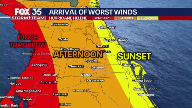

Live updates: Tropical Storm Helene nears hurricane strength in Caribbean on trek to Florida
Tropical Storm Helene is nearing hurricane strength just offshore of the northeastern coast of the Yucatan Peninsula toward the Gulf of Mexico, according to the National Hurricane Center (NHC). It's expected to become a major hurricane (Category 3 or higher) before making landfall in Florida's Big Bend region on Thursday.
Tropical Storm Helene is nearing hurricane strength just offshore of the northeastern coast of the Yucatan Peninsula toward the Gulf of Mexico, according to the National Hurricane Center (NHC). It's expected to become a major hurricane (Category 3 or higher) before making landfall in Florida's Big Bend region on Thursday.


Coolest day of the week
Today will be the coolest day of the week.
Today will be the coolest day of the week.


A Major Cooling Trend For Your Wednesday
Significant Cooling Trend Underway! Temperatures will be 10 to 15 degrees lower than todays. Fog and low clouds will cover all nine Bay Area Counties by Wednesday morning. High temperatures will be in the 70s and low 80s. Warmer weather for Thursday into the weekend. Have a great day! Bill
Significant Cooling Trend Underway! Temperatures will be 10 to 15 degrees lower than todays. Fog and low clouds will cover all nine Bay Area Counties by Wednesday morning. High temperatures will be in the 70s and low 80s. Warmer weather for Thursday into the weekend. Have a great day! Bill


Cooling on the way
Our recent hot stretch will be coming to an end. The inland Heat Advisory is set to expire at 8 pm today. You can expect a big blanket of clouds over the bay Wednesday morning. Partly sunny skies are expected later in the day. Highs should range from the low 60s near the coast to the mid 80s inland. Have a great Wednesday! -Mark
Our recent hot stretch will be coming to an end. The inland Heat Advisory is set to expire at 8 pm today. You can expect a big blanket of clouds over the bay Wednesday morning. Partly sunny skies are expected later in the day. Highs should range from the low 60s near the coast to the mid 80s inland. Have a great Wednesday! -Mark


Heat Advisory continues for one more day for the inland east bay.
It's a mostly sunny, warmer start to the day with afternoon highs ranging from upper 60s in Pacifica to upper 90s inland. Cooler weather moves in tomorrow.
It's a mostly sunny, warmer start to the day with afternoon highs ranging from upper 60s in Pacifica to upper 90s inland. Cooler weather moves in tomorrow.
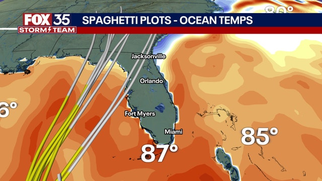

Florida storm live updates: Watches expand as Potential Tropical Cyclone Nine expected to strengthen
Potential Tropical Cyclone Nine formed in the northwestern Caribbean Sea on Monday morning and is forecast to become a hurricane later this week, according to the National Hurricane Center (NHC).
Potential Tropical Cyclone Nine formed in the northwestern Caribbean Sea on Monday morning and is forecast to become a hurricane later this week, according to the National Hurricane Center (NHC).


One More Day Of Heat Advisories
One more day of very warm to hot weather. The Head Advisories will be dropped on Wednesday with a significant cool down.
One more day of very warm to hot weather. The Head Advisories will be dropped on Wednesday with a significant cool down.


Super thick fog, then sun
Monday morning will start off with super thick fog, which will clear up by the afternoon. Sunny for all inland.
Monday morning will start off with super thick fog, which will clear up by the afternoon. Sunny for all inland.