

5.6-magnitude earthquake rattles Mendocino County
A preliminary 5.6-magnitude earthquake rattled residents in Mendocino County.
A preliminary 5.6-magnitude earthquake rattled residents in Mendocino County.


2 massive earthquakes rock Venezuela in less than a minute
In less than a minute’s time, two massive earthquakes shook the coast of Venezuela on Wednesday evening, turning buildings into rubble as panicked people rushed onto the streets for safety.
In less than a minute’s time, two massive earthquakes shook the coast of Venezuela on Wednesday evening, turning buildings into rubble as panicked people rushed onto the streets for safety.
Cooler pattern
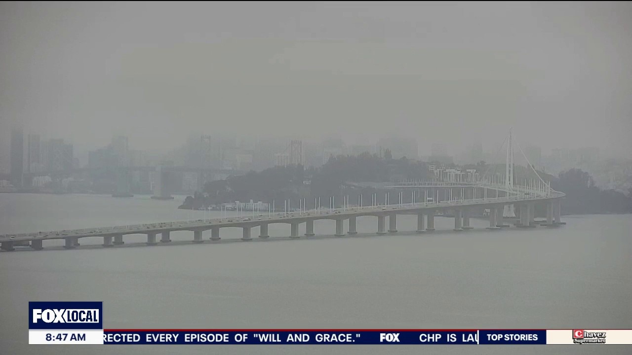
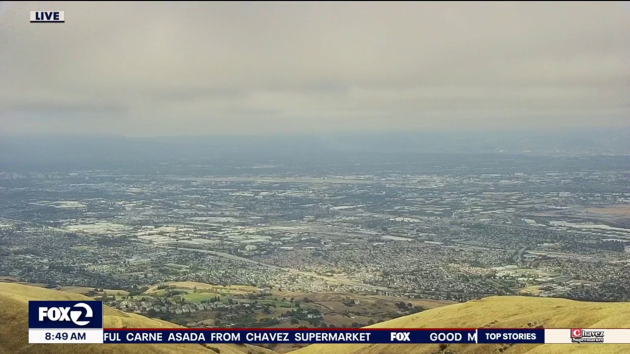
Low clouds will blanket a good portion of the Bay Area Thursday morning. The clouds will clear back to near the shoreline later in the day. Highs should range from the low 60s to the mid 80s. A cooler system will move into the area Friday. Winds will be increasing too. Gusts could approach 40 mph.
Low clouds will blanket a good portion of the Bay Area Thursday morning. The clouds will clear back to near the shoreline later in the day. Highs should range from the low 60s to the mid 80s. A cooler system will move into the area Friday. Winds will be increasing too. Gusts could approach 40 mph.

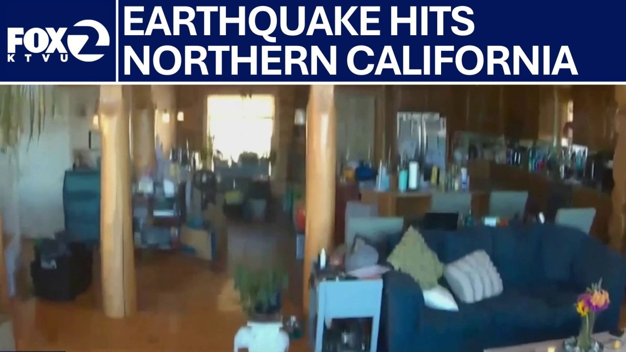
Mendocino County 5.6 earthquake damages several buildings
After the 5.6 earthquake shook Mendocino County earlier Wednesday morning, people around the area are dealing with and cleaning up the aftermath.
After the 5.6 earthquake shook Mendocino County earlier Wednesday morning, people around the area are dealing with and cleaning up the aftermath.


5.6-magnitude earthquake in Mendocino County
The USGS registered an earthquake with a magnitude of 5.6 in Mendocino County on Wednesday morning, with some minor injuries and damage reported including cracked home structures, knocked-out power, broken water pipes and fallen pictures and vases.
The USGS registered an earthquake with a magnitude of 5.6 in Mendocino County on Wednesday morning, with some minor injuries and damage reported including cracked home structures, knocked-out power, broken water pipes and fallen pictures and vases.
Final Coastal Warning: Deadly Sneaker Wave Risk Active Through Wednesday
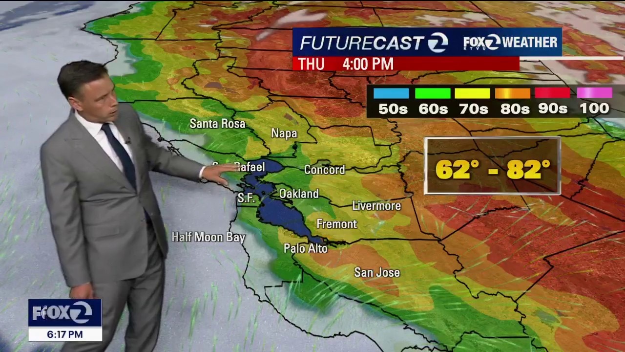
The brief midweek heat spike peaks tomorrow, but a major upper-level storm system will arrive by Friday to slash temperatures and bring howling, 40-mph wind gusts through the weekend. 1. Final Hours for the Beach Warning (Wednesday Expiration) The Threat: The long-period southerly swell is still actively battering the coast this evening. The Window: The Beach Hazards Statement remains in effect until Wednesday 5 PM. Danger: Deceptive sneaker waves and intense rip currents remain highly active on all Pacific beaches. 2. Tonight's Coastal Visibility Alert The Impact: Because the marine layer is shallower tonight (1,200 feet), the fog will not spread quite as far inland as previous nights. Instead, it will pack tightly against the coastal hills. The Hazard: Expect dense fog and rapid visibility drops along immediate coastal highways and coastal terrain through Wednesday morning with localized drizzle.. 3. Midweek Heat Peak (Wednesday & Thursday) The Trend: Subtle high pressure is compressing the marine layer to around 1,200 feet. Because of this, tomorrow morning's fog will clear out earlier than today. The Numbers: Inland valleys will reach the mid/high 80s which is seasonal!
The brief midweek heat spike peaks tomorrow, but a major upper-level storm system will arrive by Friday to slash temperatures and bring howling, 40-mph wind gusts through the weekend. 1. Final Hours for the Beach Warning (Wednesday Expiration) The Threat: The long-period southerly swell is still actively battering the coast this evening. The Window: The Beach Hazards Statement remains in effect until Wednesday 5 PM. Danger: Deceptive sneaker waves and intense rip currents remain highly active on all Pacific beaches. 2. Tonight's Coastal Visibility Alert The Impact: Because the marine layer is shallower tonight (1,200 feet), the fog will not spread quite as far inland as previous nights. Instead, it will pack tightly against the coastal hills. The Hazard: Expect dense fog and rapid visibility drops along immediate coastal highways and coastal terrain through Wednesday morning with localized drizzle.. 3. Midweek Heat Peak (Wednesday & Thursday) The Trend: Subtle high pressure is compressing the marine layer to around 1,200 feet. Because of this, tomorrow morning's fog will clear out earlier than today. The Numbers: Inland valleys will reach the mid/high 80s which is seasonal!

Europe record heatwave turns deadly after 40 drownings reported in France
A record-breaking heatwave that is sweeping across Europe has killed 40 people in France so far, according to French Prime Minister Sébastien Lecornu.
A record-breaking heatwave that is sweeping across Europe has killed 40 people in France so far, according to French Prime Minister Sébastien Lecornu.
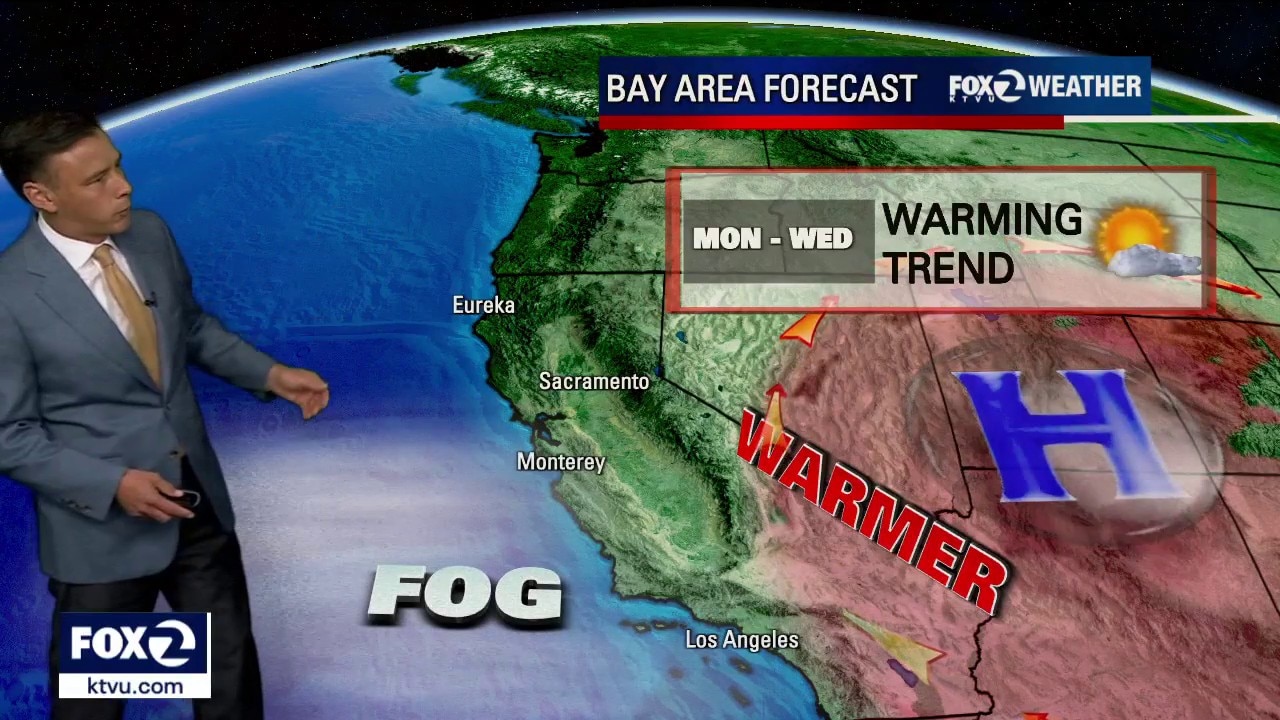
Warming trend
Welcome to summer! A warmer pattern will settle into the Bay Area over the next 3 days. Low clouds will resurface near the coast and bay Monday morning. The clouds will clear back to near the coast later in the day. Highs should range from the mid 60s to the upper 80s.
Welcome to summer! A warmer pattern will settle into the Bay Area over the next 3 days. Low clouds will resurface near the coast and bay Monday morning. The clouds will clear back to near the coast later in the day. Highs should range from the mid 60s to the upper 80s.
Classic pattern for first day of summer
Happy 1st day of summer everyone! Mother nature is responding with a minor warm up, especially inland. Low clouds and patchy drizzle will clear out to mostly sunny skies for most today. High will range from 60s in Pacifica to 80s inland.
Happy 1st day of summer everyone! Mother nature is responding with a minor warm up, especially inland. Low clouds and patchy drizzle will clear out to mostly sunny skies for most today. High will range from 60s in Pacifica to 80s inland.
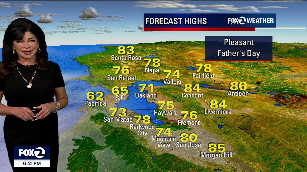
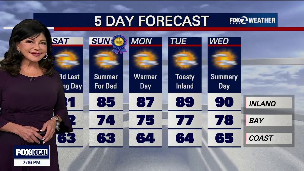
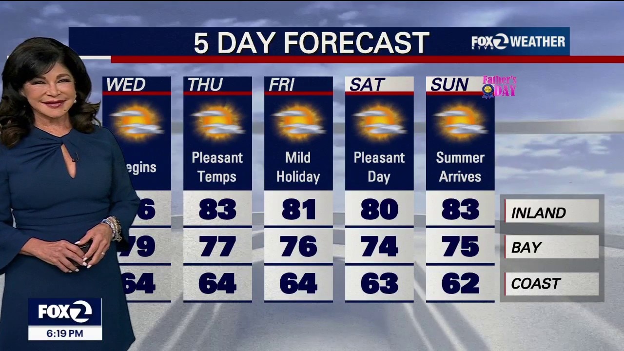
Summer arrives for Father's day
Father's Day will be pleasant, as a weak ridge of high pressure moves into the region. It will bring sunshine and slightly warmer temperatures away from the coast, though dangerous beach conditions and an upcoming midweek heat spike remain the main long-term concerns. 1. Father's Day Weather • The Forecast: It is looking like a beautiful Father’s Day across the area. A weak, incoming ridge of high pressure is compressing the marine layer, allowing morning clouds to clear out much faster than they did today. • The Temperatures: Inland will climb several degrees higher than yesterday, reaching comfortable highs in the 70s to mid-80s. • The Coast Note: While inland areas bask in the sun, coastal beaches will struggle to see clearing and will remain cool and overcast with only brief clearing. 2. Beach Warning Extended • The Threat: Powerful storms in the Southern Hemisphere are continuing to churn up the Pacific Ocean. • The Warning: A Beach Hazards Statement has been officially extended through Wednesday afternoon for all Pacific coastlines, especially steep beaches in the North Bay, San Mateo, and Santa Cruz counties. • Danger: Deceptive sneaker waves can surge dozens of feet up dry sand completely unannounced during long lulls in the surf. Combined with severe rip currents, swimming is highly hazardous. Stay off coastal rocks and never turn your back on the ocean.
Father's Day will be pleasant, as a weak ridge of high pressure moves into the region. It will bring sunshine and slightly warmer temperatures away from the coast, though dangerous beach conditions and an upcoming midweek heat spike remain the main long-term concerns. 1. Father's Day Weather • The Forecast: It is looking like a beautiful Father’s Day across the area. A weak, incoming ridge of high pressure is compressing the marine layer, allowing morning clouds to clear out much faster than they did today. • The Temperatures: Inland will climb several degrees higher than yesterday, reaching comfortable highs in the 70s to mid-80s. • The Coast Note: While inland areas bask in the sun, coastal beaches will struggle to see clearing and will remain cool and overcast with only brief clearing. 2. Beach Warning Extended • The Threat: Powerful storms in the Southern Hemisphere are continuing to churn up the Pacific Ocean. • The Warning: A Beach Hazards Statement has been officially extended through Wednesday afternoon for all Pacific coastlines, especially steep beaches in the North Bay, San Mateo, and Santa Cruz counties. • Danger: Deceptive sneaker waves can surge dozens of feet up dry sand completely unannounced during long lulls in the surf. Combined with severe rip currents, swimming is highly hazardous. Stay off coastal rocks and never turn your back on the ocean.


‘Show Your Stripes Day’: These cities had the most higher-than-average temperatures
As communities prepare to mark “Show Your Stripes Day” on June 20, new climate data reveals just how dramatically temperatures have risen over the past century.
As communities prepare to mark “Show Your Stripes Day” on June 20, new climate data reveals just how dramatically temperatures have risen over the past century.


Too hot for hops: France bans booze at music festival, many public places
Festival-goers in France who were looking forward to having a beer during the country’s major musical celebration, Fete de la Musique, may have to find something else to sip on.
Festival-goers in France who were looking forward to having a beer during the country’s major musical celebration, Fete de la Musique, may have to find something else to sip on.


3 Grand Canyon deaths blamed on the heat as 100+ degree days continue
Temperatures are expected to reach triple digits again this week at the Grand Canyon, which has seen an increasing number of heat-related incidents, including the deaths of three hikers.
Temperatures are expected to reach triple digits again this week at the Grand Canyon, which has seen an increasing number of heat-related incidents, including the deaths of three hikers.
More of the same today with changes arriving tomorrow
Happy weekend everyone! A near repeat in weather is expected for the final day of spring. Partly sunny at the coast to mostly sunny inland is in the afternoon forecast with temps. ranging from low 60s in Pacifica to Upper 70s in Livermore. A warming trend begins for Father's Day and first day of summer.
Happy weekend everyone! A near repeat in weather is expected for the final day of spring. Partly sunny at the coast to mostly sunny inland is in the afternoon forecast with temps. ranging from low 60s in Pacifica to Upper 70s in Livermore. A warming trend begins for Father's Day and first day of summer.


Summer solstice 2026: When is it and what to know
The first day of summer arrives this weekend. June 21 marks the first day of the summer solstice in the Northern Hemisphere this year, according to the Farmer’s Almanac.
The first day of summer arrives this weekend. June 21 marks the first day of the summer solstice in the Northern Hemisphere this year, according to the Farmer’s Almanac.
Summer arrives Sunday, but will it FEEL like it?
Tomorrow will be a near-carbon copy of today. Expect a cloudy morning with patchy coastal drizzle followed by slow clearing to the coast, keeping daytime temperatures below seasonal temperatures. A contrast between the cloudy coast and sunlit inland areas will spin up strong onshore winds. Expect widespread gusts of 20 to 30 mph, with gusts up to 40 mph. Highs will bank from low-mid 60s at the Coast to 81 inland. A Beach Hazards Statement remains active through early Sunday for sneaker waves and dangerous rip currents. Do NOT turn your back to the ocean and stay out of the water. The cooling upper trough will lose its grip as shortwave high pressure begins compressing the marine layer, starting a subtle warming trend on Father's Day and the first day of summer on Sunday.
Tomorrow will be a near-carbon copy of today. Expect a cloudy morning with patchy coastal drizzle followed by slow clearing to the coast, keeping daytime temperatures below seasonal temperatures. A contrast between the cloudy coast and sunlit inland areas will spin up strong onshore winds. Expect widespread gusts of 20 to 30 mph, with gusts up to 40 mph. Highs will bank from low-mid 60s at the Coast to 81 inland. A Beach Hazards Statement remains active through early Sunday for sneaker waves and dangerous rip currents. Do NOT turn your back to the ocean and stay out of the water. The cooling upper trough will lose its grip as shortwave high pressure begins compressing the marine layer, starting a subtle warming trend on Father's Day and the first day of summer on Sunday.
Cooling trend
The Bay Area cooling trend continues. Low clouds and drizzle return to the area Friday morning. Partly sunny skies are expected later in day. Winds will be picking up again (20 - 35 mph). Highs should range from the low 60s to the upper 70s. The Beach Hazards Statement is in effect until 5 am Sunday.
The Bay Area cooling trend continues. Low clouds and drizzle return to the area Friday morning. Partly sunny skies are expected later in day. Winds will be picking up again (20 - 35 mph). Highs should range from the low 60s to the upper 70s. The Beach Hazards Statement is in effect until 5 am Sunday.
Slightly cooler
Low clouds will blanket most of the Bay Area Thursday morning. Drizzle could also resurface near the coast and bay. The clouds will gradually retreat to near the coast. Slightly cooler temperatures are expected too. Highs should range from the low 60s to the low 80s.
Low clouds will blanket most of the Bay Area Thursday morning. Drizzle could also resurface near the coast and bay. The clouds will gradually retreat to near the coast. Slightly cooler temperatures are expected too. Highs should range from the low 60s to the low 80s.
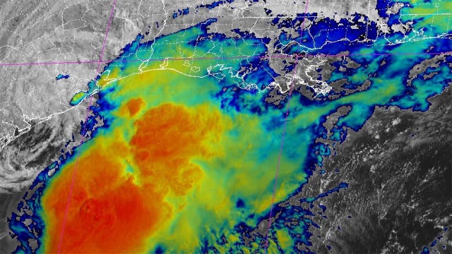

Tropical Storm Arthur makes landfall on Texas coast
Tropical Storm Arthur has made landfall on the Texas coast just hours after it formed.
Tropical Storm Arthur has made landfall on the Texas coast just hours after it formed.
The heat eases, but another weather hazard remains
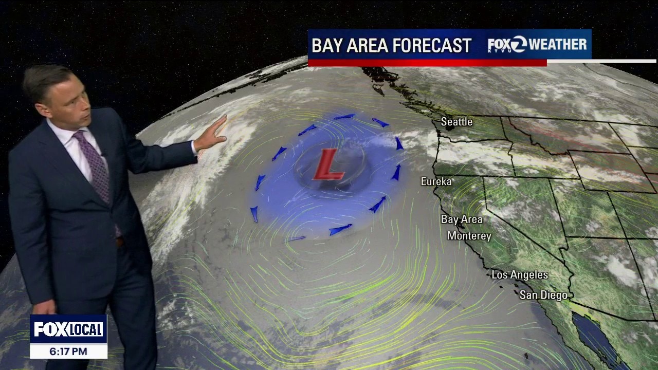
Sneaker Wave Threat: The Beach Hazards Statement has been extended for all SF/Bay Area Pacific coastlines through 5 AM Thursday. Powerful southerly swells are creating random, massive waves that can surge high up the dry sand without warning. Late-Night Flooding: The Coastal Flood Advisory is active until 5:00 AM Wednesday for the SF coast. Keep vehicles away from low-lying coastal parking lots and frontages tonight, as tides will crest up to 2 feet above normal around midnight The weather ridge over the West Coast has peaked and a cooling trend begins tomorrow. 1. Updated High Tide Windows (Heading into Midweek) Astronomical factors and ocean swells are keeping late-night tides dangerously high, though water levels are beginning a very slow step-down from the weekend peak. Tonight (Late Tuesday Night / Wednesday Morning): Water levels will crest at 12:56 AM tonight, spiking a significant 1.7 feet above normal (hitting 7.5 feet) Expect saltwater flooding on low-lying bayshore and coastal roads. Tomorrow Night (Late Wednesday Night / Thursday Morning): The final peak of this cycle arrives at 1:51 AM Thursday, tracking at 1.2 feet above normal (7.1 feet) 2. Fog Schedule Tonight's Fog Timeline: The marine layer is holding steady at 1,100 to 1,500 feet.Expect another widespread blanketing of coastal areas and West San Francisco by Wednesday morning. 3. Temperature & Wind Wednesday (The Cooldown Begins): The upper-level high-pressure system begins breaking down tomorrow. While the coast will stay in the 60s under marine influence, inland locations will drop 2 to 5 degrees cooler than today, but still above average East Bay. Southwest breezy winds 10 - 20 mph. Enjoy your Wednesday!
Sneaker Wave Threat: The Beach Hazards Statement has been extended for all SF/Bay Area Pacific coastlines through 5 AM Thursday. Powerful southerly swells are creating random, massive waves that can surge high up the dry sand without warning. Late-Night Flooding: The Coastal Flood Advisory is active until 5:00 AM Wednesday for the SF coast. Keep vehicles away from low-lying coastal parking lots and frontages tonight, as tides will crest up to 2 feet above normal around midnight The weather ridge over the West Coast has peaked and a cooling trend begins tomorrow. 1. Updated High Tide Windows (Heading into Midweek) Astronomical factors and ocean swells are keeping late-night tides dangerously high, though water levels are beginning a very slow step-down from the weekend peak. Tonight (Late Tuesday Night / Wednesday Morning): Water levels will crest at 12:56 AM tonight, spiking a significant 1.7 feet above normal (hitting 7.5 feet) Expect saltwater flooding on low-lying bayshore and coastal roads. Tomorrow Night (Late Wednesday Night / Thursday Morning): The final peak of this cycle arrives at 1:51 AM Thursday, tracking at 1.2 feet above normal (7.1 feet) 2. Fog Schedule Tonight's Fog Timeline: The marine layer is holding steady at 1,100 to 1,500 feet.Expect another widespread blanketing of coastal areas and West San Francisco by Wednesday morning. 3. Temperature & Wind Wednesday (The Cooldown Begins): The upper-level high-pressure system begins breaking down tomorrow. While the coast will stay in the 60s under marine influence, inland locations will drop 2 to 5 degrees cooler than today, but still above average East Bay. Southwest breezy winds 10 - 20 mph. Enjoy your Wednesday!