

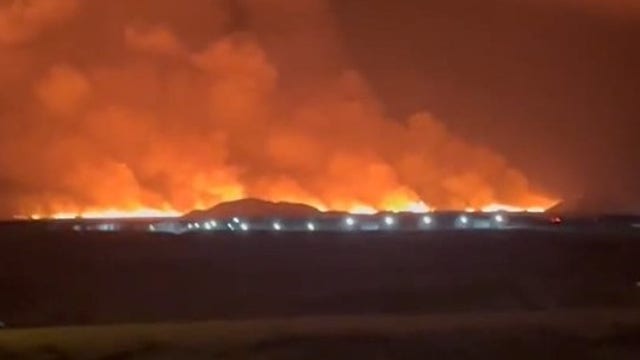

Iceland volcano erupts near Grindavik after swarm of earthquakes rattle region
The IMO has been warning of the possible eruption ever since a swarm of "intense" earthquakes was detected north of Grindavík at the end of October.
The IMO has been warning of the possible eruption ever since a swarm of "intense" earthquakes was detected north of Grindavík at the end of October.


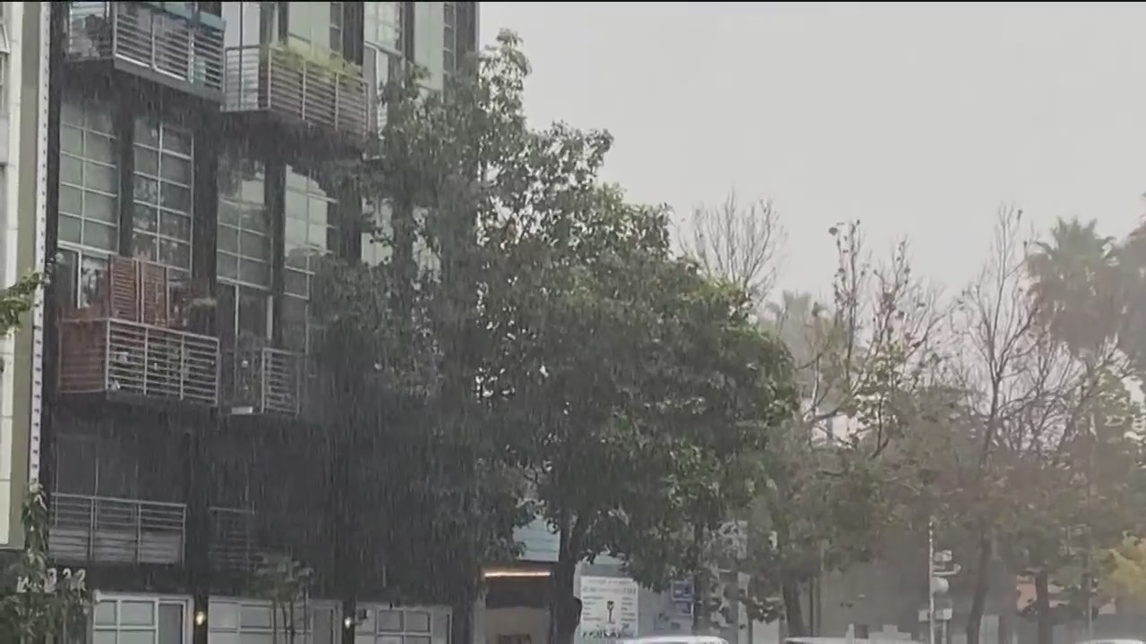
Bay Area will see rain over next couple of days
The Bay Area experienced heavy downpours on Monday, causing road flooding in some areas.
The Bay Area experienced heavy downpours on Monday, causing road flooding in some areas.

Wet weather to last next couple of days
Rain soaked the Bay Area on Monday and the wet weather system is expected to last through the middle of the week..
Rain soaked the Bay Area on Monday and the wet weather system is expected to last through the middle of the week..
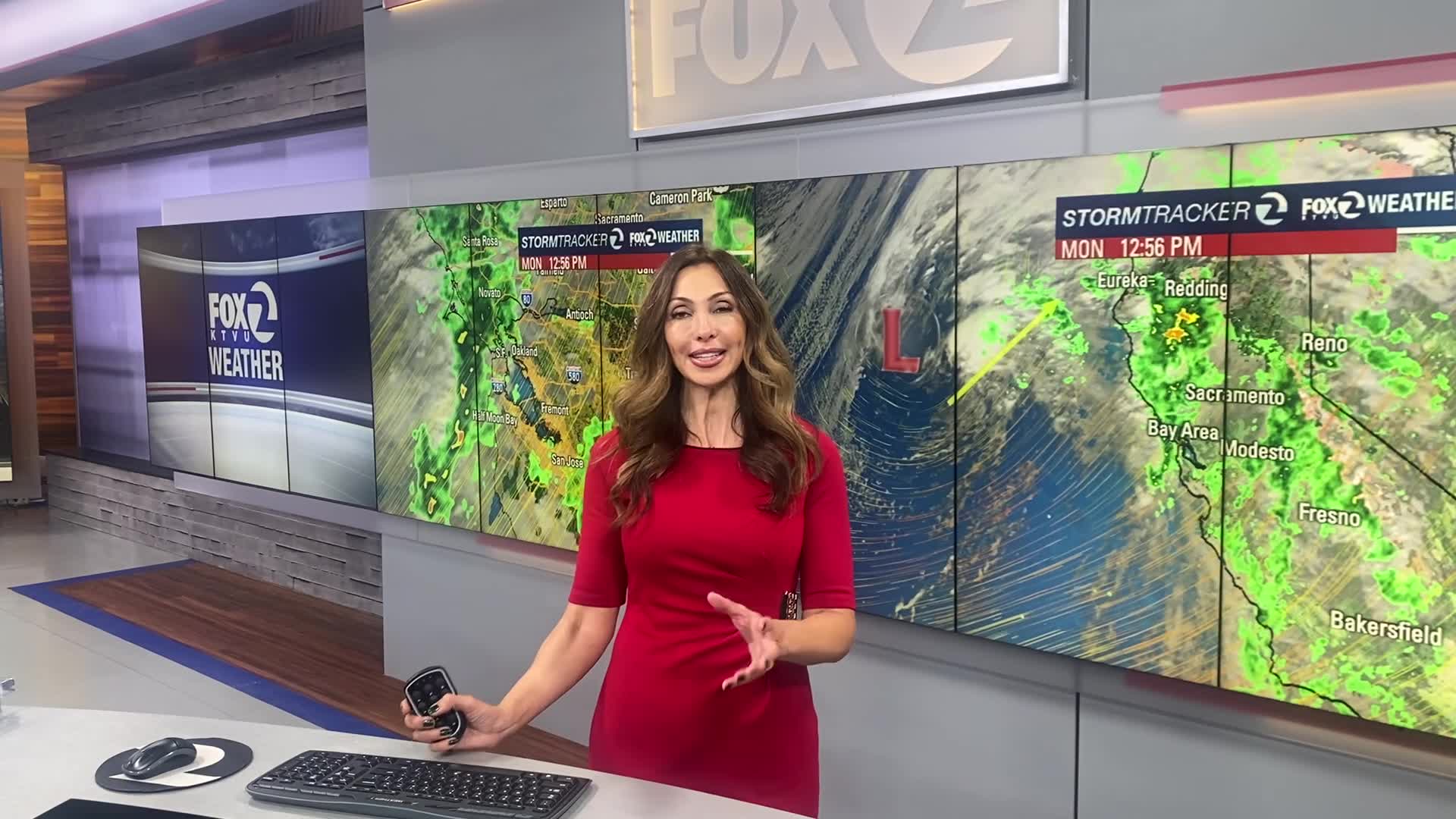

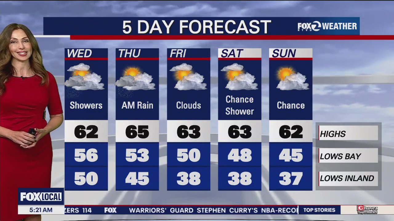
Off-and-on rain to continue for days
More rain will hit the Bay Area on Monday evening that will continue with showers on Tuesday morning. But there's more on the way after that. Rosemary Orozco says there will be bouts of rain until Wednesday night and possibly Thursday morning.
More rain will hit the Bay Area on Monday evening that will continue with showers on Tuesday morning. But there's more on the way after that. Rosemary Orozco says there will be bouts of rain until Wednesday night and possibly Thursday morning.


Stunning lightning flashes across purple sky in Pacifica
A KTVU photographer captured a stunning image of lightning flashing across a purple sky in Pacifica, as a multi-day storm promised to pummel the Bay Area.
A KTVU photographer captured a stunning image of lightning flashing across a purple sky in Pacifica, as a multi-day storm promised to pummel the Bay Area.
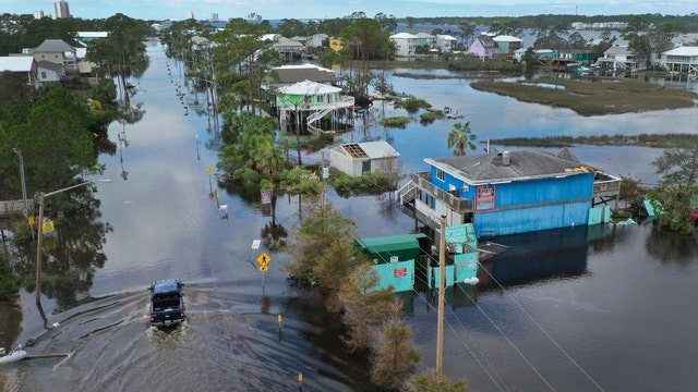

Study suggests people are leaving some U.S. neighborhoods because of flood risks
A recent study implies that flood risk and climate change are compelling people to move from their homes to places where the threat isn’t as high.
A recent study implies that flood risk and climate change are compelling people to move from their homes to places where the threat isn’t as high.

Bay Area showers cause slick roads, car crashes
Bay Area residents woke Monday morning to rain and wind, causing a fair number of traffic accidents on the roads.
Bay Area residents woke Monday morning to rain and wind, causing a fair number of traffic accidents on the roads.

Showers
Rosemary Orozco says today will be wet with lots of rain showers.
Rosemary Orozco says today will be wet with lots of rain showers.


Rain rolls in to the Bay Area, last-minute preparations underway
Last-minute preparations were underway across the Bay Area Sunday with several days of forecast rain rolling into the region. Some homeowners, who hoped to spend the day picking out presents, instead found themselves grabbing sandbags and clearing gutters and drains.
Last-minute preparations were underway across the Bay Area Sunday with several days of forecast rain rolling into the region. Some homeowners, who hoped to spend the day picking out presents, instead found themselves grabbing sandbags and clearing gutters and drains.

Scattered showers heading to the Bay Area Sunday
Rain is expected to begin on Sunday, Dec. 17 and stay in the area for several days. KTVU Meteorologist Rosemary Orozco shares the latest forecast.
Rain is expected to begin on Sunday, Dec. 17 and stay in the area for several days. KTVU Meteorologist Rosemary Orozco shares the latest forecast.


Bay Area gears up for heavy rain as holiday travel ratchets up
Mother Nature appears poised to throw a curveball into the Bay Area's way with holiday travel ratcheting up. The region is gearing up for several days of heavy rain as millions plan to take to the skies and roads over Christmas and New Year's.
Mother Nature appears poised to throw a curveball into the Bay Area's way with holiday travel ratcheting up. The region is gearing up for several days of heavy rain as millions plan to take to the skies and roads over Christmas and New Year's.


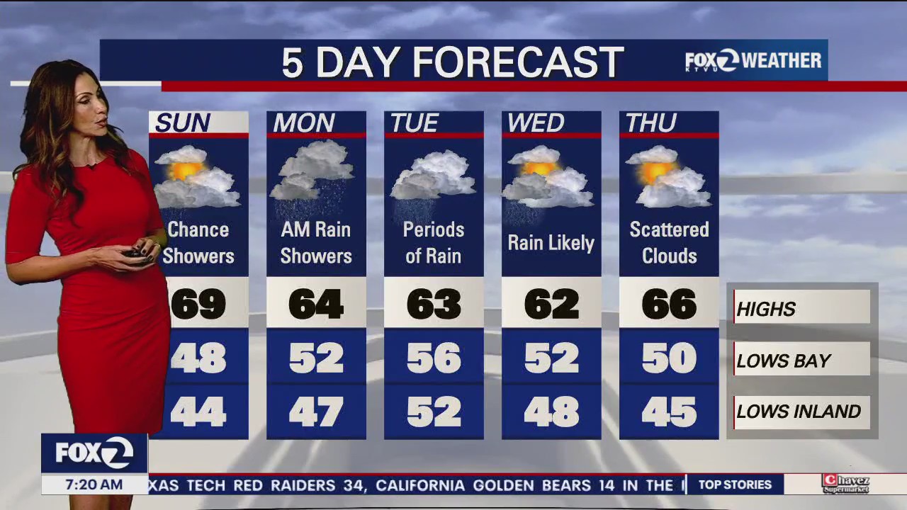
Scattered showers expected Sunday, rainier days ahead next week
A large storm heading our way over the Pacific Ocean is expected to bring scattered showers beginning on Sunday morning.
A large storm heading our way over the Pacific Ocean is expected to bring scattered showers beginning on Sunday morning.
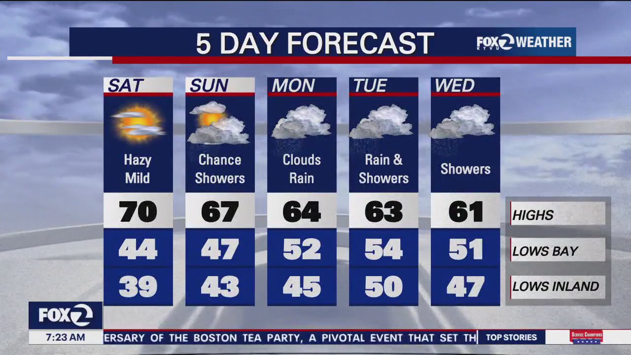

Sunny Saturday with clouds expected
KTVU Meteorologist Rosemary Orozco shares the latest forecast.
KTVU Meteorologist Rosemary Orozco shares the latest forecast.
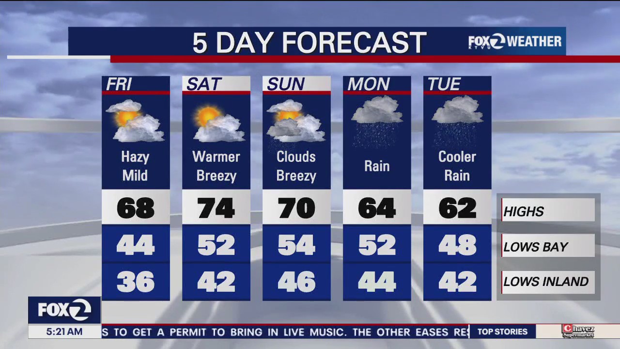

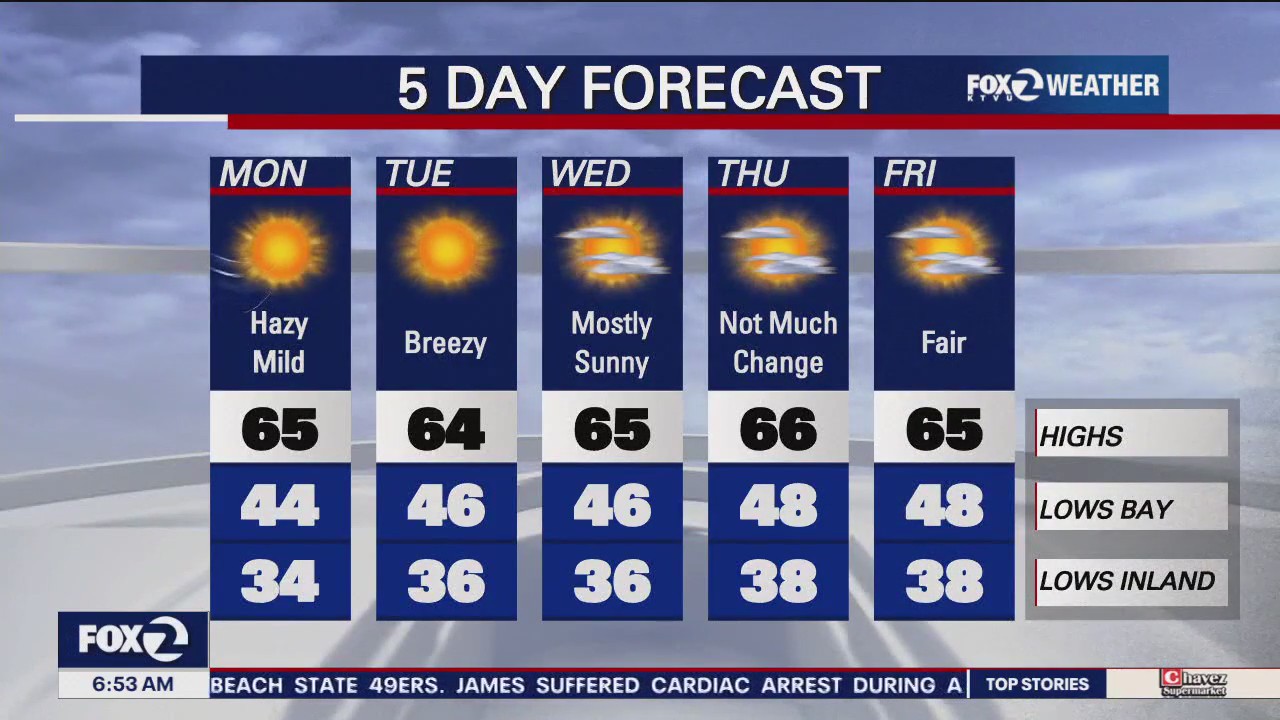
Hazy, mild
Steve Paulson says today will be hazy and mild.
Steve Paulson says today will be hazy and mild.
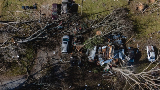

Infant tossed by Tennessee tornado found alive in downed tree
A 4-month old boy has survived after a tornado in Tennessee sucked him up from his family’s mobile home.
A 4-month old boy has survived after a tornado in Tennessee sucked him up from his family’s mobile home.

Chilly morning will lead to a mild Thursday
KTVU Meteorologist Steve Paulson shares the latest forecast.
KTVU Meteorologist Steve Paulson shares the latest forecast.


PG&E asks for another rate hike due to climate change
Climate change has aggravated inflation, but nowhere more than with Pacific Gas & Electric, the first major utility to deal with far more effects of extreme weather related to fire and floods.
Climate change has aggravated inflation, but nowhere more than with Pacific Gas & Electric, the first major utility to deal with far more effects of extreme weather related to fire and floods.
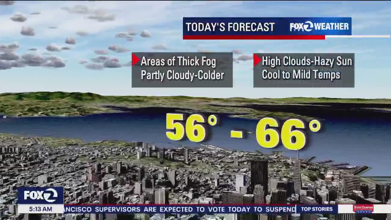

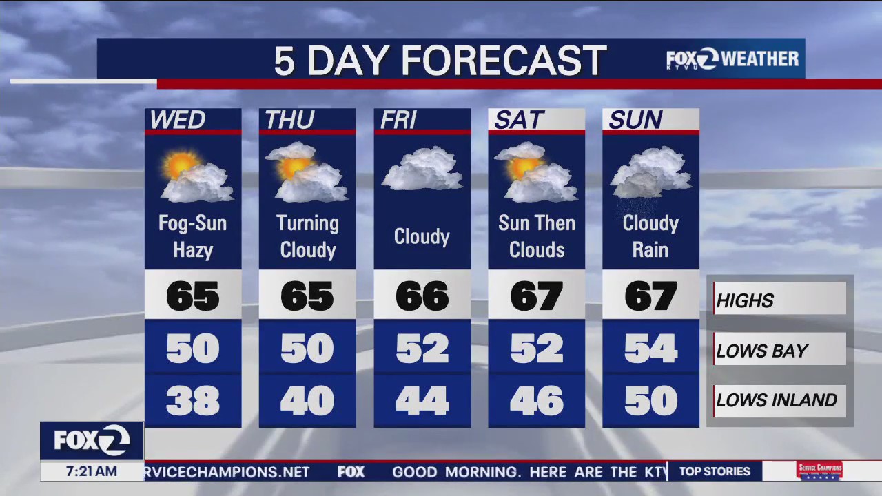
Thick fog, hazy sun
Steve Paulson says today will start off with thick fog, paving the way for hazy sun in the afternoon.
Steve Paulson says today will start off with thick fog, paving the way for hazy sun in the afternoon.

Heavy fog brings temperatures up by double digits on Tuesday
KTUV Meteorologist Steve Paulson shares the latest forecast.
KTUV Meteorologist Steve Paulson shares the latest forecast.

Hazy, mild
Steve Paulson says today will be hazy and mild. Highs in the 60s.
Steve Paulson says today will be hazy and mild. Highs in the 60s.