


Temps in the 70s
Temperatures should mostly be in the 70s today.
Temperatures should mostly be in the 70s today.

Another system on the way
As one system moves out to the east, we are tracking a stronger storm in the Pacific. This system may impact your weekend plans. Thursday morning starts off with some clouds. Partly sunny skies are expected later in the day. Highs should range from the mid 60s to the mid 70s. The next system, linked up with an Atmospheric River, moves into the picture Saturday morning. The significant ran will be focused to the north of the Bay Area. The bulk of the rain, up to .75 inches, will be in the North Bay. Shower chances may linger in the Sunday forecast.
As one system moves out to the east, we are tracking a stronger storm in the Pacific. This system may impact your weekend plans. Thursday morning starts off with some clouds. Partly sunny skies are expected later in the day. Highs should range from the mid 60s to the mid 70s. The next system, linked up with an Atmospheric River, moves into the picture Saturday morning. The significant ran will be focused to the north of the Bay Area. The bulk of the rain, up to .75 inches, will be in the North Bay. Shower chances may linger in the Sunday forecast.

Mostly cloudy tonight, dry and warmer Thursday
Mostly cloudy with clouds clearing later this evening. Breezy and cooler with a spotty shower until tonight and a chance of a thunderstorm. Dry and slightly warmer with sunshine returning Thursday!
Mostly cloudy with clouds clearing later this evening. Breezy and cooler with a spotty shower until tonight and a chance of a thunderstorm. Dry and slightly warmer with sunshine returning Thursday!
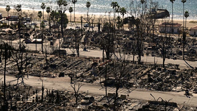

These are the 14 billion-dollar weather disasters of 2025, according to data
New data shows that 14 separate billion-dollar weather and climate disasters slammed the U.S. in just six months of 2025 – topping $100B in damages.
New data shows that 14 separate billion-dollar weather and climate disasters slammed the U.S. in just six months of 2025 – topping $100B in damages.

Temperatures cool, rain possible in the South Bay
Conditions in the Bay Area are expected to cool off, and some rain may be seen in the Santa Cruz and San Jose areas.
Conditions in the Bay Area are expected to cool off, and some rain may be seen in the Santa Cruz and San Jose areas.

Wednesday's Weather Whiplash!
Here we go again! Another change in your weather pattern! - Slight chance for isolated showers and thunderstorms from Bay Area southward tonight into Wednesday morning. - Seasonal temperatures through much of the week. - Rain chances return Friday evening through the weekend across the Bay Area. Widespread cooler temps beginning this weekend. A system to the south of the Bay Area will produce Mostly Cloudy skies overnight and into your Wednesday morning with a chance of a shower or isolated thunderstorm. Wednesday afternoon will be Partly Cloudy and cooler with low 60s at the Coast to the low 70s Inland. Another shot of rai returns late Friday through Saturday. A Beach Hazard Alert remains in effect until Wednesday late evening for waves 12-17 feet! Possible rip currents and sneaker waves.
Here we go again! Another change in your weather pattern! - Slight chance for isolated showers and thunderstorms from Bay Area southward tonight into Wednesday morning. - Seasonal temperatures through much of the week. - Rain chances return Friday evening through the weekend across the Bay Area. Widespread cooler temps beginning this weekend. A system to the south of the Bay Area will produce Mostly Cloudy skies overnight and into your Wednesday morning with a chance of a shower or isolated thunderstorm. Wednesday afternoon will be Partly Cloudy and cooler with low 60s at the Coast to the low 70s Inland. Another shot of rai returns late Friday through Saturday. A Beach Hazard Alert remains in effect until Wednesday late evening for waves 12-17 feet! Possible rip currents and sneaker waves.


New FEMA rules, grant delays put disaster response at risk, states say
Some states have seen substantial cuts to grants, which officials believe affect their agencies’ abilities to respond to emergency situations and natural disasters.
Some states have seen substantial cuts to grants, which officials believe affect their agencies’ abilities to respond to emergency situations and natural disasters.

Temps to remain cool and clear
The weather was clear and temperatures mild on Tuesday. Temperatures are expected to cool as the week progresses.
The weather was clear and temperatures mild on Tuesday. Temperatures are expected to cool as the week progresses.

One more warm day
Our warm stretch continues for one more day. Tuesday afternoon highs should range from the upper 60s to the low 80s. We are expecting more clouds in the Wednesday forecast. Rain chances, especially in the North Bay, will be increasing by the weekend.
Our warm stretch continues for one more day. Tuesday afternoon highs should range from the upper 60s to the low 80s. We are expecting more clouds in the Wednesday forecast. Rain chances, especially in the North Bay, will be increasing by the weekend.

Sunny today, changes on the way
The sunny, unseasonably warm weather will carry on into Tuesday before cloudier, cooler weather arrives mid week and rain chances increase by the weekend.
The sunny, unseasonably warm weather will carry on into Tuesday before cloudier, cooler weather arrives mid week and rain chances increase by the weekend.
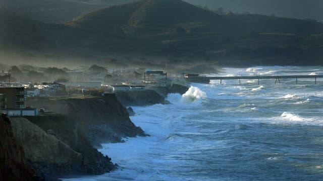

NWS warns of sneaker waves along Northern California coast
The National Weather Service is warning beachgoers along the Northern California coast to stay vigilant as dangerous sneaker waves and strong rip currents.
The National Weather Service is warning beachgoers along the Northern California coast to stay vigilant as dangerous sneaker waves and strong rip currents.

Mild pattern continues...for now
Mostly sunny skies and warm temperatures will highlight our Monday forecast. Highs should range from the low 70s to the low 80s. The weather pattern will be changing later in the week. A storm will move in from the north and could affect your weekend plans.
Mostly sunny skies and warm temperatures will highlight our Monday forecast. Highs should range from the low 70s to the low 80s. The weather pattern will be changing later in the week. A storm will move in from the north and could affect your weekend plans.

Foggy start, sunny finish
Patchy dense fog this morning will clear by mid to late morning. Mostly sunny skies will take center stage for the afternoon with temperatures ranging from 60s at the coast to low 80s inland. An increase in rip currents and sneaker waves returns tonight.
Patchy dense fog this morning will clear by mid to late morning. Mostly sunny skies will take center stage for the afternoon with temperatures ranging from 60s at the coast to low 80s inland. An increase in rip currents and sneaker waves returns tonight.

Sunny and unseasonably warm
Sunny, unseasonably warm weather is joining us for the weekend. If you're plans include our coast, there is an Alert for increased risk of rip currents and sneaker waves. Afternoon highs today will range from low 70s at the coast to low 80s inland. A gradual cool down will culminate with a chance for wet weather by next weekend.
Sunny, unseasonably warm weather is joining us for the weekend. If you're plans include our coast, there is an Alert for increased risk of rip currents and sneaker waves. Afternoon highs today will range from low 70s at the coast to low 80s inland. A gradual cool down will culminate with a chance for wet weather by next weekend.

Plan Outdoor Activities!
- Warming and drying trend this weekend with light, offshore winds in the higher elevations through early next week. Highs on Saturday from the upper 60s and low 70s at the Coast to the low 80s Inland! - Long period northwesterly swell will bring an increased risk of sneaker waves and rip currents to the coastline tonight through Saturday night. - Weak cooling trend next week with unsettled weather potentially returning late week.
- Warming and drying trend this weekend with light, offshore winds in the higher elevations through early next week. Highs on Saturday from the upper 60s and low 70s at the Coast to the low 80s Inland! - Long period northwesterly swell will bring an increased risk of sneaker waves and rip currents to the coastline tonight through Saturday night. - Weak cooling trend next week with unsettled weather potentially returning late week.
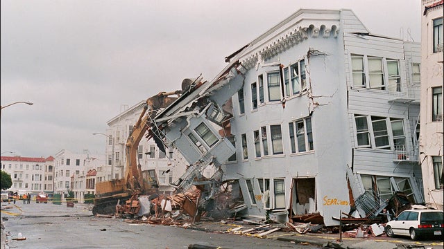

Worry over USGS staffing as Bay Area marks 36 years since Loma Prieta earthquake
A retired scientist with the USGS worries about the impact the government shutdown is having on the agency's earthquake science research program.
A retired scientist with the USGS worries about the impact the government shutdown is having on the agency's earthquake science research program.

Temps in the 70s
Today's temps will mostly be in the 70s.
Today's temps will mostly be in the 70s.

Nice weather ahead
A pleasant weather pattern is setting up just in time for the weekend! Patchy clouds should resurface Friday morning. Mostly sunny skies and mild temperatures will highlight the afternoon forecast. Highs should range from the upper 60s to the upper 70s. Get outside this weekend. The weather looks great!
A pleasant weather pattern is setting up just in time for the weekend! Patchy clouds should resurface Friday morning. Mostly sunny skies and mild temperatures will highlight the afternoon forecast. Highs should range from the upper 60s to the upper 70s. Get outside this weekend. The weather looks great!


Berkeley rattled by another earthquake
An earthquake with a magnitude of 3.1 rattled Berkeley on Thursday morning.
An earthquake with a magnitude of 3.1 rattled Berkeley on Thursday morning.
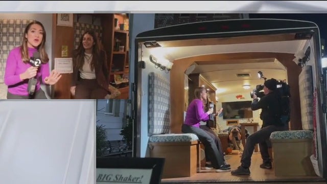

Great Shakeout: Here's what to do in a California earthquake
Millions of Californians are set to "Drop, Cover, and Hold On" on Thursday as part of the annual Great California ShakeOut earthquake drill, aimed at educating the public on earthquake preparedness.
Millions of Californians are set to "Drop, Cover, and Hold On" on Thursday as part of the annual Great California ShakeOut earthquake drill, aimed at educating the public on earthquake preparedness.