

When is it going to rain? Timeline of this week's storm in the Bay Area

Atmospheric Rivers: What are they and how do they form?
With an atmospheric river headed towards the Bay this week, we asked KTVU meteorologist Mark Tamayo to give us a break down on what exactly they are and how they form.
March 11, 2025 Update: See the latest storm timeline here
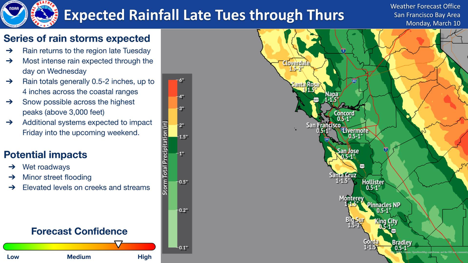
OAKLAND, Calif. - Rain is returning to the Bay Area this week with the most intense portion of the storm expected on Wednesday, according to the National Weather Service.
The series of rainstorms is expected to begin late Tuesday and continue on and off through the weekend.
Here's a look at the storm timeline this week across the Bay Area.
Rain Timeline
Tuesday
What's next:
The rain is expected to begin late Tuesday night into the Wednesday overnight hours, according to the NWS.
The heaviest rain is expected in the greater North Bay into Lake County, and south into Santa Clara and Monterey counties.
"One more day of nice conditions on Tuesday before an active pattern ramping up on Tuesday night," said KTVU meteorologist Roberta Gonzales. "After a quiet start to the work week, my computer model suggests the rain will begin in the North Bay about 4 a.m. on Wednesday"
National Weather Service
Wednesday
Wednesday is when the Bay Area will see the most intense rainfall during the week, the NWS predicts. Residents can expect wet roadways, rising water levels on creeks and streams, and minor flooding.
Thunderstorms are possible Wednesday night, along with hail.
While the coastal ranges will see the highest rainfall totals, the East Bay and South Bay will see periods of heavy rain and strong winds on Wednesday.
Thursday
By Thursday morning, the Bay Area will see a break from the wet weather.
"We'll just have spotty showers through Thursday morning, and then we buy a bit of a break before another round of rainfall arrives early Friday morning, into early Saturday morning," Gonzales said.

Minor changes today, wet weather on the way
Cold mornings and mild afternoons will remain for today and Tuesday before Bay Area rain, wind and Sierra snow arrives mid week.
Friday
The next round of storms will move into the Bay Area on Friday, bringing enough rain to bring weekly totals up to 3 inches.
Weekend Weather
We'll see another brief break from the rain Saturday morning, with the storm returning Sunday.
Winter Storm Warning
What we know:
This week's rainfall in the Bay Area means heavy snowfall around Lake Tahoe.
KTVU's Rosemary Orozco predicts upwards of 5 feet of fresh snow in the Sierra.
Heavy snow will begin on Wednesday and could hit lower elevations, down to 3,000 feet, by that evening.
On Thursday, the upper Sierra foothills may also see some snow, down to 2,000 feet, according to the NWS.
A winter storm warning will be in effect Tuesday evening through Thursday evening in cities surrounding Lake Tahoe, including Incline Village, South Lake Tahoe, Truckee and Tahoe City.
"Travel could be very difficult to impossible," the NWS said. "The hazardous conditions could impact the Wednesday and Thursday commutes. Strong winds could cause damage to trees and power lines as well as blowing snow that could cause near whiteout conditions."
Closer to home, the Bay Area may also see a light dusting of snow on the region's higher peaks, like Mount Hamilton and Mount Diablo.
The Source: National Weather Service, KTVU's meteorologists.