


Seasonal temps
Today will see seasonal temperatures and high clouds.
Today will see seasonal temperatures and high clouds.


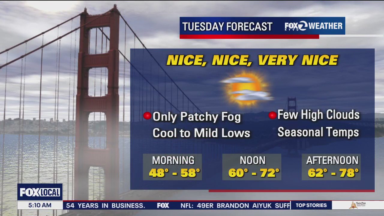
Nice and quiet for Tuesday
Only subtle weather changes are expected for Tuesday. A cool start to the day with temperatures ranging from low 40s inland to low 50s around the bay, will be followed by seasonal afternoon highs, ranging from low 60s at the coast to low 80s in our valleys.
Only subtle weather changes are expected for Tuesday. A cool start to the day with temperatures ranging from low 40s inland to low 50s around the bay, will be followed by seasonal afternoon highs, ranging from low 60s at the coast to low 80s in our valleys.


Cooler temps
Today will be cooler with highs ranging from the 60s to 80s.
Today will be cooler with highs ranging from the 60s to 80s.

High clouds, light winds, and unseasonably warm today
A chilly start followed by a warm finish can be expected today. High clouds will roll overhead later today with afternoon highs ranging from 70 at the coast to low 80s inland. An increase in clouds and onshore breeze on the way with fog expected to return by tomorrow.
A chilly start followed by a warm finish can be expected today. High clouds will roll overhead later today with afternoon highs ranging from 70 at the coast to low 80s inland. An increase in clouds and onshore breeze on the way with fog expected to return by tomorrow.


Mild to warm forecast
The Red Flag Warning has expired. Your Sunday forecast features partly to mostly sunny skies. Slightly cooler temperatures are expected. Highs should range from the upper 60s near the coast to the low 80s inland. Enjoy the rest of your weekend! -Mark
The Red Flag Warning has expired. Your Sunday forecast features partly to mostly sunny skies. Slightly cooler temperatures are expected. Highs should range from the upper 60s near the coast to the low 80s inland. Enjoy the rest of your weekend! -Mark


Red Flag Warning continues until 5pm today
A Red Flag Warning continues until 5pm today as dry, breezy conditions continue elevated fire danger. Afternoon highs will range from low 70s at the coast to mid 80s inland.
A Red Flag Warning continues until 5pm today as dry, breezy conditions continue elevated fire danger. Afternoon highs will range from low 70s at the coast to mid 80s inland.


Red Flag Warning continues
Fire danger remains elevated across the entire Bay Area. A Red Flag Warning is in place through 5 pm Saturday. Mostly sunny skies and warm temperatures will highlight your Saturday forecast. Highs should range from the low 70s near the coast to the low 80s inland. The warm weather pattern remains in place through early next week. Have a great weekend! -Mark
Fire danger remains elevated across the entire Bay Area. A Red Flag Warning is in place through 5 pm Saturday. Mostly sunny skies and warm temperatures will highlight your Saturday forecast. Highs should range from the low 70s near the coast to the low 80s inland. The warm weather pattern remains in place through early next week. Have a great weekend! -Mark


Sun and wind
Today will be sunny and windy with highs in the low 80s.
Today will be sunny and windy with highs in the low 80s.


Stronger winds later today
Your Thursday forecast features sunny skies and breezy conditions. Highs should range from the low 60s near the coast to the upper 70s inland. Stronger winds, out of the north, will be increasing tonight. Gusts could approach 50 mph in the hills. The windy pattern will lead to an increase in the fire danger. A Red Flag Warning begins tonight and lasts through most of Saturday.
Your Thursday forecast features sunny skies and breezy conditions. Highs should range from the low 60s near the coast to the upper 70s inland. Stronger winds, out of the north, will be increasing tonight. Gusts could approach 50 mph in the hills. The windy pattern will lead to an increase in the fire danger. A Red Flag Warning begins tonight and lasts through most of Saturday.


Strong winds
Strong winds are in the forecast.
Strong winds are in the forecast.


Increasing fire danger
The sunshine returns in your Thursday forecast. Northerly winds will be increasing during the afternoon. Those winds will boost the fire danger. A Red Flag Warning has been posted for the entire Bay Area from 11 pm Thursday to 5 pm Saturday. Gusts could approach 60 mph in the hills. The dangerous winds are expected to diminish by Sunday.
The sunshine returns in your Thursday forecast. Northerly winds will be increasing during the afternoon. Those winds will boost the fire danger. A Red Flag Warning has been posted for the entire Bay Area from 11 pm Thursday to 5 pm Saturday. Gusts could approach 60 mph in the hills. The dangerous winds are expected to diminish by Sunday.


Rainbow in the sky
KTVU viewers sent in rainbow photos from all over the Bay Area.
KTVU viewers sent in rainbow photos from all over the Bay Area.


Lots of clouds
Today will be cloudy with light rain possible up north.
Today will be cloudy with light rain possible up north.


Tracking shower chances tomorrow
Most of the Bay Area is enjoying a nice Tuesday afternoon. We are tracking a weak system that is expected to arrive Wednesday morning. You can count on more clouds tomorrow. The chance of scattered showers has also been added to the forecast. Once this system moves to the east later in the week, winds will increase from the north. The dry winds will increase the fire danger. Gusts could approach 60 mph in the hills. A Red Flag Warning begins Thursday night. -Mark
Most of the Bay Area is enjoying a nice Tuesday afternoon. We are tracking a weak system that is expected to arrive Wednesday morning. You can count on more clouds tomorrow. The chance of scattered showers has also been added to the forecast. Once this system moves to the east later in the week, winds will increase from the north. The dry winds will increase the fire danger. Gusts could approach 60 mph in the hills. A Red Flag Warning begins Thursday night. -Mark


Looking ahead to drizzle
Today should be nice, but there is drizzle in the forecast this week.
Today should be nice, but there is drizzle in the forecast this week.


Slightly above average
Today's temps will be slightly above average wit the mercury soaring to the 70s and 80s.
Today's temps will be slightly above average wit the mercury soaring to the 70s and 80s.


Turning partly cloudy and mild for the next few days
Behind a weak storm we are drying out with the next chance for rain on Wednesday. Afternoon highs will range from 60s at the coast to near 80 degrees inland.
Behind a weak storm we are drying out with the next chance for rain on Wednesday. Afternoon highs will range from 60s at the coast to near 80 degrees inland.


Clouds clearing out Sunday
Low clouds and fog will blanket most of the Bay Area Sunday morning. We are expecting increasing sunshine during the afternoon. Highs should range from the mid 60s near the coast to the low 80s inland. Pleasant weather returns Monday - Tuesday. We are tracking another chance of showers by midweek. Enjoy the rest of your weekend! -Mark
Low clouds and fog will blanket most of the Bay Area Sunday morning. We are expecting increasing sunshine during the afternoon. Highs should range from the mid 60s near the coast to the low 80s inland. Pleasant weather returns Monday - Tuesday. We are tracking another chance of showers by midweek. Enjoy the rest of your weekend! -Mark


Mostly Cloudy and a chance of showers for some today
A weak system will bring mostly cloudy skies and a chance of showers to parts of the bay area, especially favoring the North Bay and San Francisco. Afternoon highs will range from upper 60s at the coast to upper 70s inland.
A weak system will bring mostly cloudy skies and a chance of showers to parts of the bay area, especially favoring the North Bay and San Francisco. Afternoon highs will range from upper 60s at the coast to upper 70s inland.


Clouds moving in this weekend
A weather system will approach Northern California this weekend. The associated clouds will move into the Bay Area Saturday morning. Shower chances have also been added to the forecast tomorrow. The best shower chances will b e focused in the North Bay. Highs should range from the low 60s near the coast to the upper 70s inland. Partly sunny skies return to the Sunday forecast. We are tracking another system that could boost shower chances by midweek. Have a great weekend! -Mark
A weather system will approach Northern California this weekend. The associated clouds will move into the Bay Area Saturday morning. Shower chances have also been added to the forecast tomorrow. The best shower chances will b e focused in the North Bay. Highs should range from the low 60s near the coast to the upper 70s inland. Partly sunny skies return to the Sunday forecast. We are tracking another system that could boost shower chances by midweek. Have a great weekend! -Mark