


California dry streak, why 15 days of no rain matter
After a wet and stormy start to winter, the Bay Area has now gone 15 consecutive days without measurable rainfall, giving us a stretch of dry, mild January weather.
After a wet and stormy start to winter, the Bay Area has now gone 15 consecutive days without measurable rainfall, giving us a stretch of dry, mild January weather.


Morning fog, cooler
Today will start off foggy and then be cooler in the high 50s.
Today will start off foggy and then be cooler in the high 50s.


Fog returns Friday morning
Dense fog will resurface in the inland valleys Friday morning. We are expecting partly sunny skies later in the day. Plan on cooler temperatures. Highs should range from the mid 50s to the low 60s. The weekend will be dry. Winds will be picking up in our local hills early Saturday morning.
Dense fog will resurface in the inland valleys Friday morning. We are expecting partly sunny skies later in the day. Plan on cooler temperatures. Highs should range from the mid 50s to the low 60s. The weekend will be dry. Winds will be picking up in our local hills early Saturday morning.


The lowest wind chill ever recorded
A New Hampshire mountain holds the record for the lowest wind chill ever recorded in the U.S.
A New Hampshire mountain holds the record for the lowest wind chill ever recorded in the U.S.


What to do if your flight gets canceled due to winter storms
Flight cancellations are likely this weekend as a massive winter storm is expected to cripple much of the U.S.
Flight cancellations are likely this weekend as a massive winter storm is expected to cripple much of the U.S.


Slight chance of showers
A system in the Pacific will drift toward Southern California Thursday morning. The slight chance of showers has been added to the forecast through early Thursday. Shower chances will be favoring the South Bay. The cloudy conditions during the morning will give way to partly cloudy skies later in the day. Highs should range from the upper 50s to the low 60s. Have a great Thursday! -Mark
A system in the Pacific will drift toward Southern California Thursday morning. The slight chance of showers has been added to the forecast through early Thursday. Shower chances will be favoring the South Bay. The cloudy conditions during the morning will give way to partly cloudy skies later in the day. Highs should range from the upper 50s to the low 60s. Have a great Thursday! -Mark


A few sunny breaks
Today will see a few sunny breaks, with highs in the low 60s.
Today will see a few sunny breaks, with highs in the low 60s.


Do trees actually explode from 'extreme' cold?
Can trees really explode in the extreme cold? Rumors are spreading on social media that the frigid temperatures in the Upper Midwest this week could mean exploding trees. FOX 9's Cody Matz breaks down this viral claim.
Can trees really explode in the extreme cold? Rumors are spreading on social media that the frigid temperatures in the Upper Midwest this week could mean exploding trees. FOX 9's Cody Matz breaks down this viral claim.


Ted Cruz spotted on a plane to Laguna Beach ahead of Texas winter storm
A photo of Senator Ted Cruz on a plane to Laguna Beach as Texas braces for a winter storm is drawing a lot of attention.
A photo of Senator Ted Cruz on a plane to Laguna Beach as Texas braces for a winter storm is drawing a lot of attention.

Potentially catastrophic winter storm now threatens over 35 states, prompts Winter Storm Watches for millions
Behind the winter storm itself, Arctic temperatures could freeze snow and ice, potentially creating long-duration power outages and paralyzing travel for days.
Behind the winter storm itself, Arctic temperatures could freeze snow and ice, potentially creating long-duration power outages and paralyzing travel for days.


A few sunny breaks
Today will be in the low 60s with a few sunny breaks.
Today will be in the low 60s with a few sunny breaks.


Partly cloudy, cool
Today will be foggy and cooler. Highs in the low 60s.
Today will be foggy and cooler. Highs in the low 60s.


Tuesday clouds
We are expecting another round of fog in some of the inland valleys Tuesday morning. High clouds will also stream into the Bay Area from the Pacific. Highs should range from the mid 50s to the low 60s. Our dry weather stretch will continue through the weekend.
We are expecting another round of fog in some of the inland valleys Tuesday morning. High clouds will also stream into the Bay Area from the Pacific. Highs should range from the mid 50s to the low 60s. Our dry weather stretch will continue through the weekend.
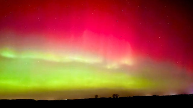

Northern lights expected to light up sky in parts of the US Monday
A severe geomagnetic storm watch is in effect Monday night as people prepare for northern lights to dazzle the night sky across the U.S. Here's where.
A severe geomagnetic storm watch is in effect Monday night as people prepare for northern lights to dazzle the night sky across the U.S. Here's where.


Cold start to MLK Day will give way to warmer Monday
Monday morning will be cold with some fog, but temps will warm as the day goes on.
Monday morning will be cold with some fog, but temps will warm as the day goes on.


Mild to warm Monday
No big changes to the Bay Area forecast. Our dry stretch continues. Patchy fog will resurface in the inland valleys Monday morning. The afternoon forecast features mostly sunny skies and mild temperatures away from the fog. Highs should range from the upper 50s to the low 70s. We are expecting a cooling trend later in the week.
No big changes to the Bay Area forecast. Our dry stretch continues. Patchy fog will resurface in the inland valleys Monday morning. The afternoon forecast features mostly sunny skies and mild temperatures away from the fog. Highs should range from the upper 50s to the low 70s. We are expecting a cooling trend later in the week.


Another round of unseasonable warmth in store for the Bay Area
Dry weather is expected for the area, possibly extending into next weekend.
Dry weather is expected for the area, possibly extending into next weekend.

Snow in Florida: See photos and videos
Does it snow in Florida? It can – and it did.
Does it snow in Florida? It can – and it did.


Spare the air alert in place as temps remain above average
Temperatures in the Bay Area are hovering about five degrees above average.
Temperatures in the Bay Area are hovering about five degrees above average.


Bay Area gets taste of spring weather
Relatively warm temperatures are settling around the Bay Area, which meteorologist Bryan Gallo said are much deserved after back-to-back atmospheric rivers.
Relatively warm temperatures are settling around the Bay Area, which meteorologist Bryan Gallo said are much deserved after back-to-back atmospheric rivers.