


Thousands of PG&E customers lose power during Bay Area storm
PG&E crews have been working hard Sunday to restore power, after heavy winds and rain shook the Bay Area on Saturday.
PG&E crews have been working hard Sunday to restore power, after heavy winds and rain shook the Bay Area on Saturday.


King Tides, highest of the season, roll over San Francisco's Embarcadero
This weekend's storm that swept through the Bay Area was combined with King Tides, which contributed to flooding in many areas.
This weekend's storm that swept through the Bay Area was combined with King Tides, which contributed to flooding in many areas.


Ocean heat wave known as 'The Blob' blamed for killing half the population of bird species
The new study suggested that 4 million seabirds died following unusually warm conditions in the northeastern Pacific Ocean between 2014 and 2016.
The new study suggested that 4 million seabirds died following unusually warm conditions in the northeastern Pacific Ocean between 2014 and 2016.


Partly sunny and cool for the afternoon
After a cold, foggy start, the Bay Area will be partly sunny and cool today. Afternoon highs will range from the low to upper 50s. King tides will continue to bring the threat of coastal flooding through Monday afternoon. Wet weather returns tomorrow.
After a cold, foggy start, the Bay Area will be partly sunny and cool today. Afternoon highs will range from the low to upper 50s. King tides will continue to bring the threat of coastal flooding through Monday afternoon. Wet weather returns tomorrow.


Severe weather Saturday
A Saturday storm provided enough instability and led to severe thunderstorms. Scotts Valley was the site of a tornado. Mark Tamayo has the storm recap.
A Saturday storm provided enough instability and led to severe thunderstorms. Scotts Valley was the site of a tornado. Mark Tamayo has the storm recap.


EF1 tornado in Scotts Valley, big rigs and cars overturned from high-speed winds
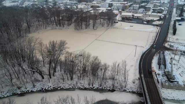
A powerful winter storm battered the Bay Area Friday night into Saturday, causing widespread issues, power outages and downed trees and flooding. Off-and-on rain and strong, gusty winds continued to hammer the region as the storm moves east.
A powerful winter storm battered the Bay Area Friday night into Saturday, causing widespread issues, power outages and downed trees and flooding. Off-and-on rain and strong, gusty winds continued to hammer the region as the storm moves east.


Dry weather returning to the bay area this afternoon
Following a stormy start to the day, including multiple advisories and a brief Tornado Warning for parts of SF area, the wet, windy weather is moving out. A Flood Watch continues for the North Bay until Sunday Afternoon. A High Surf Advisory until 7 PM for our coast and Coastal Flooding Advisory through the weekend due to King Tides. Snow continues in the Sierra with a Winter Storm Warning until 10 PM.
Following a stormy start to the day, including multiple advisories and a brief Tornado Warning for parts of SF area, the wet, windy weather is moving out. A Flood Watch continues for the North Bay until Sunday Afternoon. A High Surf Advisory until 7 PM for our coast and Coastal Flooding Advisory through the weekend due to King Tides. Snow continues in the Sierra with a Winter Storm Warning until 10 PM.


Stronger storm moving in
A strong storm will produce heavy rain early Saturday morning. A Flood Watch is posted for the North Bay. Winds will also be a factor. Gusts could approach 60 mph near the coast. Thunderstorm chances have also been added to the forecast. The heavy rain Saturday morning will taper to scattered showers during the afternoon.
A strong storm will produce heavy rain early Saturday morning. A Flood Watch is posted for the North Bay. Winds will also be a factor. Gusts could approach 60 mph near the coast. Thunderstorm chances have also been added to the forecast. The heavy rain Saturday morning will taper to scattered showers during the afternoon.


Heavy, steady rain in evening
Heavy, steady rain is expected in the evening.
Heavy, steady rain is expected in the evening.


A reunion with the rain
Our dry stretch, now up to 15 days, will be coming to an end. Rain will spread south across the Bay Area early Thursday morning. Showers will remain in the forecast, off and on, for the remainder of the day. A stronger storm will be moving in Friday night. Heavy rain, along with the chance of thunderstorms, will highlight our Saturday morning forecast. We are tracking more rain chances for early next week. -Mark
Our dry stretch, now up to 15 days, will be coming to an end. Rain will spread south across the Bay Area early Thursday morning. Showers will remain in the forecast, off and on, for the remainder of the day. A stronger storm will be moving in Friday night. Heavy rain, along with the chance of thunderstorms, will highlight our Saturday morning forecast. We are tracking more rain chances for early next week. -Mark


Rain on the way: Here's when wet weather will arrive in the Bay Area
According to the National Weather Service, “multiple” storm systems will hit the Bay Area and central California coast through next week. Here's when the rain will arrive.
According to the National Weather Service, “multiple” storm systems will hit the Bay Area and central California coast through next week. Here's when the rain will arrive.


Rain returns to the Bay Area, 1st precipitation since before Thanksgiving
Rain is expected to return to the San Francisco Bay Area this week for the first time since before Thanksgiving, according to the National Weather Service.
Rain is expected to return to the San Francisco Bay Area this week for the first time since before Thanksgiving, according to the National Weather Service.

Brown snow falls on Maine town prompting warning from officials: Don’t eat it
The unusual incident took place in Rumford, about 80 miles north of Portland.
The unusual incident took place in Rumford, about 80 miles north of Portland.


Cool and dry start to Wednesday morning
KTVU meteorologist Steve Paulson shares the latest forecast.
KTVU meteorologist Steve Paulson shares the latest forecast.


Our rain break is coming to an end
The Bay Area dry stretch, now up to 14 days, will soon be coming to an end. We are tracking 2 systems developing in the Pacific. Wednesday morning will be dry and cold. A Frost Advisory has been reissued for the North Bay and the inland valleys. Clouds will be increasing during the afternoon. Rain chances will be increasing during the Wednesday night - early Thursday morning time frame. This is not a major storm. Rainfall estimates currently range from .10" in the South Bay to 1.00" in the North Bay. A stronger system is scheduled to arrive Friday night -Mark
The Bay Area dry stretch, now up to 14 days, will soon be coming to an end. We are tracking 2 systems developing in the Pacific. Wednesday morning will be dry and cold. A Frost Advisory has been reissued for the North Bay and the inland valleys. Clouds will be increasing during the afternoon. Rain chances will be increasing during the Wednesday night - early Thursday morning time frame. This is not a major storm. Rainfall estimates currently range from .10" in the South Bay to 1.00" in the North Bay. A stronger system is scheduled to arrive Friday night -Mark


Malibu fire prompts evacuations at Pepperdine University
Thousands of Southern California residents are under evacuation orders and warnings as firefighters battle a wildfire in Malibu.
Thousands of Southern California residents are under evacuation orders and warnings as firefighters battle a wildfire in Malibu.


Strong winds whip through Bay Area, spark fire in Malibu
Whipping winds raced through California late Monday night, causing trees to fall and fires to ignite throughout the state.
Whipping winds raced through California late Monday night, causing trees to fall and fires to ignite throughout the state.


Whipping winds, rain ahead
Winds whipped through the Bay Area with rain ahead on Thursday.
Winds whipped through the Bay Area with rain ahead on Thursday.


Magnitude 3.9 earthquake strikes in Sonoma County
The US Geological Survey recorded a magnitude 3.9 earthquake near the Geysers, west of Cobb in Sonoma County on Monday night.
The US Geological Survey recorded a magnitude 3.9 earthquake near the Geysers, west of Cobb in Sonoma County on Monday night.


Magnitude 5.5 earthquake strikes Nevada, east of Lake Tahoe
The earthquake struck northeast of the town of Yerington, about 74 miles east of South Lake Tahoe.
The earthquake struck northeast of the town of Yerington, about 74 miles east of South Lake Tahoe.