

CZU August Lighting Complex Fire: Favorable weather helps firefight in Santa Cruz County

SANTA CRUZ, Calif. - The CZU August Lightning Complex Fire grew to 78,000 acres by Monday morning, Cal Fire crews said, and was 13% contained.
As a news briefing, Cal Fire officials said that 24,300 structures remain threatened and 231 structures had burned. Of the major fires now burning in California, this fire is the third largest complex.
UPLOAD YOUR PICTURES TO THE KTVU WEATHER APP

No imminent danger to Santa Cruz or UC campus
No imminent danger to Santa Cruz or UC campus. Allie Rasmus reports
The good news, however, is that crews made good progress to the north of the complex of fires burning in San Mateo and Santa Cruz counties, and had established good control lines to the south.
The prognosis looked good for the UC Santa Cruz campus, officials said, which is nestled in a redwood forest and had to be evacuated last week.
"We are confident these lines are going to hold," said Cal Fire Battalion Chief Mark Brunton.
There is also no imminent danger to the city of Santa Cruz, officials said.
Interactive map: See where wildfires are burning across the Bay Area
70-year-old man found dead; wildfires rage through Northern California
California inmates battling wildfires despite COVID-19, early releases
'Sickening': Firefighter has wallet stolen, bank account drained during Santa Cruz fire fight
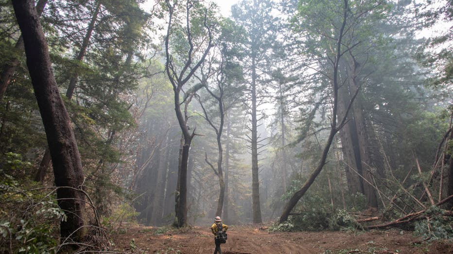
SANTA CRUZ, CA - AUGUST 22: Scott Bullock, a Cal Fire forester, looks to build a firebreak behind UC Santa Cruz as a defense against the CZU August Lightning Complex fire, in Santa Cruz, Calif., Saturday, Aug., 22, 2020. (Photo by Karl Mondon/MediaNe
On the northern end of the fire, in San Mateo County, the fire is no longer moving towards La Honda, Loma Mar and Pescadero.
The fire is also not moving toward Santa Clara County.
California Department of Forestry and Fire Protection incident commander Billy See said crews were taking advantage of these "small wins" and the fact that the weather had helped out with cooler temperatures and a bit of rain in the forecast.
"Mother Nature’s helped us quite a bit," See said.
On Sunday, a 70-year-old man was found dead in a community called Last Chance.
Santa Cruz County Sheriff's Deputy Chief Chris Clark said four people were still missing and three arrests had been made for people not heeding evacuation orders.
In San Mateo County, the sheriff said six people defied evacuation orders and snuck into their homes to check on their properties.
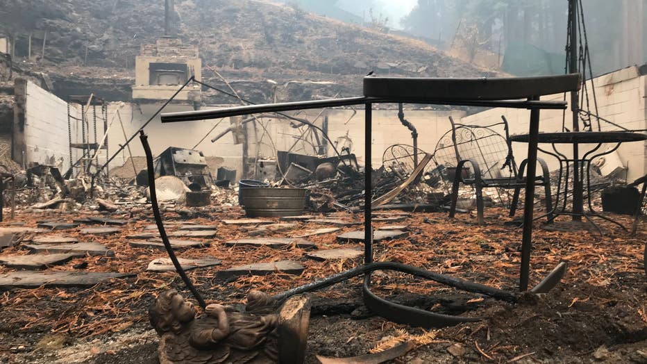
Burned homes at Pinecrest and Creek drive sin Boulder Creek. Aug. 24, 2020
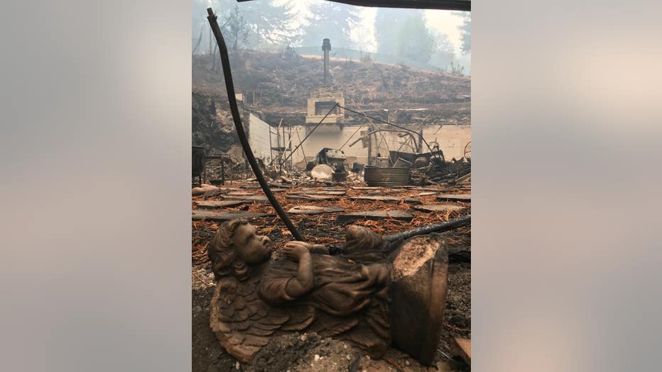
Burned homes and a statue at Pinecrest and Creek drive sin Boulder Creek. Aug. 24, 2020
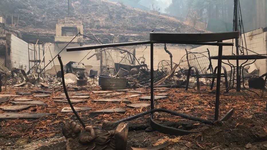
Burned homes at Pinecrest and Creek drive sin Boulder Creek. Aug. 24, 2020
EVACUATION WARNINGS FOR SAN MATEO COUNTY:
No Evacuation Warnings currently in place
EVACUATION ORDERS FOR SAN MATEO COUNTY:
Communities of Loma Mar and Dearborn Park Area (Zone SMC E018)
Pescadero Creek County Park Area (Zone SMC E024)
Butano Community Area (Zone SMC E098)
Butano State Park Area including Barranca Knolls Community (Zone SMC E019)
Butano Creek Drainage (Zone SMC E055)
South Skyline Blvd. Area near Highway 9 (SMC E049)
Russian Ridge Open Space Reserve Area (Zone SMC E027)
Middleton Tract Area (Zone SMC E044)
Portola Redwoods State Park and the Portola Heights Community Area (Zone SMC E048)
Pescadero Beach Area (Zone SMC E073) (8/20/2020 6:00 pm)
Bean Hollow Area (Zone SMC E042) (8/20/2020 6:00 pm)
Pescadero Area (Zone SMC E043) (8/20/2020 6:00 pm)
San Gregorio Area (Zone SMC E022) (8/20/2020 6:00 pm)
La Honda Area (Zone SMC E028) 8/20/2020 6:00 pm)
Red Barn Area (Zone SMC E010) (8/20/2020 6:00 pm)
Russian Bridge Open Space Area (Zone SMC E027) (8/20/2020 6:00 pm)
Skylonda Area (Zone SMC E012) (8/20/2020 6:00 pm)
Langley Hill Area ( Zone SMC E010) (8/20/2020 6:00 pm)
Bean Hollow Area (Zone SMC E042) (8/20/2020 6:00 pm)
EVACUATION WARNINGS FOR SANTA CRUZ COUNTY:
No Evacuation Warnings currently in place
EVACUATION ORDERS FOR SANTA CRUZ COUNTY:
Waterman Gap Loop, Upper HWY 236, Boulder Creek Golf Course, Heartwood Hill, Lodge Road, Community of Little Basin, Lower China Grade, Upper China Grade, Community of Kings Hwy, Lower Jamison Creek, Gallion Heights, Fallen Leaf Neighborhood, Foxglove Lane (Zones CRZ10, CRZ13, BOU36, BOU20, BOU30, BOU31, BOU36, BOU37, BOU21) (8/18/2020 10 pm)
Saratoga Toll Road, San Lorenzo Park, Riverside Grove-Community of Teilh Drive, Wildwood Road (Zones: BOU38, BOU39, BOU40, BOU41, BOU42, BOU43) (8/18/2020 7:30 PM)
Saratoga Toll Road, San Lorenzo Park, Riverside Grove-Community of Teilh Drive, Wildwood Road (BOU38, BOU39, BOU40, BOU41, BOU42, BOU43)
Everyone on Empire Grade Road, from Felton Empire north, all of Pine Flat Road, all of Ice Cream Grade, Bonny Doon Road, in between Pine Flat Road, Martin Road, and all associated side streets are under an evacuation order. (CRZ1, CRZ2, CRZ3, CRZ4, CRZ5, CRZ10, CRZ11, CRZ12, CRZ13, CRZ14, CRZ15) (8/19/2020 1:00 am)
Bonny Doon south of Ice Cream Grade, to include Pine Flat Road South is now under an evacuation order. (CRZ7, CRZ8)
Areas of Alba Road, Hubbard Gulch and Fanning Grade. (BEN 1) (8/19/2020 6:00 pm)
All areas of Ben Lomond (Zones BEN 2 – BEN 5) (8/19/2020 7:00 pm) The area of Lompico (Zones ZAY 11, ZAY 12)
All areas adjacent to the Bonny Doon and San Lorenzo Valley should be prepared to evacuate if necessary. (CRZ7, CRZ8) (8/20/2020 1:00 am)
Areas West of Highway 9 to Empire Grade
South from Bear Creek Road to Felton, this includes Ben Lomond
Paradise Park (Zones: CRZ 63, CRZ 64) (8/20/2020 7:00pm)
University of California Santa Cruz, campus only (Zone: SCZ 4) (8/20/2020 7:00pm)
The areas of Zayante Canyon (Zones: ZAY 1 – ZAY 17) (8/20/2020 1:00 pm)
Scotts Valley West of State Route 17 (Zones: SCO 1-5, SCO 7, SCO 14-20, SCO 21 – SCO 25) (8/20/2020 7:00 pm)
Davenport south (Zones: CRZ 6, CRZ 9, CRZ 17) (8/19/2020 7:00 pm)
All areas of Felton (Zones: FEL 1 – FEL 6) (8/20/2020 8:00 am)
Butano State Park area including Barrranca Knolls Community (Zone: SMC E019) (8/18/2020 4:30 pm)
Butano Creek Drainage (Zone SMC E055) (8/18/2020 4:30 pm)
Loma Mar/Deerborn Park Area (Zone SMC E018) (8/18/2020 5:00 PM)
Pescadero Creek County Park area (Zone SMC E024) (8/18/2020 5:00 pm)
East of Zayante Canyon west of State Route 17 and south of State Route 35 (Zones: CRZ 18, CRZ 19, CRZ 20) (8/20/2020 7:00 pm)
EVACUATION CENTERS
San Mateo County
Half Moon Bay High School, 1 Lewis Foster Drive, Half Moon Bay (AT CAPACITY)
San Mateo Event Center, 1346 Saratoga Drive
Santa Cruz County
Santa Cruz County Fairground, 2601 E. Lake Avenue in Watsonville
Santa Cruz Civic Auditorium, 307 Church Street, Santa Cruz (AT CAPACITY)
Seventh Day Adventist Camp Grounds, 1931 Soquel San Jose Rd (AT CAPACITY)
Cabrillo College, 6500 Soquel Drive, Aptos CA
Santa Cruz Bible Church, 440 Frederick Street, Santa Cruz
Simpkins Family Swim Center, 919 17th Ave (ADA only)
Twin Lakes Church, 2701 Cabrillo College Drive
ROAD CLOSURES
Road closures are fluid and being coordinated with evolving evacuation warnings and orders.
San Mateo County
Pescadero Creek Road between Alpine and Cloverdale Rd.
Cloverdale Road between Pescadero Creek Road and Gazos Creek.
Whitehouse Canyon Road at Highway 1
Portola Heights Road at Skyline
State Route 1 at Rossi Road
State Route 1 at Ano Nuevo
Santa Cruz County
State Route 1 at Shaffer Road to Ano Nuevo
State Route 9 at Lower Glen Arbor to Rincon Trail head
Westbound Zayante at Graham Hill Dr to Lockwood
Empire Grade at Heller Drive
Westbound State Route 35 at Upper Zayante into San Mateo County
Westbound State Route 236 at Jamison Creek
Pine Flat at Empire Grade
Ice Cream Grade at Empire Grade
Felton Empire at Fall Creek
Empire Grade at Smith Grade
Empire Grade at Felton Empire
Bonny Doon Rd at Pine Flat
Alba Rd at Empire Grade
State Route 35 at Bear Creek Rd to Boulder Creek
Granite Creek at Scotts Valley, this includes southbound offramp closure at Highway 17 at Granite Creek
Westbound Mount Hermon at La Modrona to Graham Hill Road
Zayante at State Route 35
Santa Clara County
Foothills Park to Santa Clara County line, including Los Trancos Open Space (Zones: PA-E002) (8/23/2020 6:00 pm)
South of Moody Road, West of Rancho San Antonio Open Space, West of Black Mountain to Highway 35/ Skyline (Zones: PA – E001) (8/23/2020 6:00 pm)
Monte Bello Open Space Preserve, south of Monte Bello Road to Highway 35/Skyline. (Zones: PA – E006) (8/23/2020 6:00 pm)
Upper Stevens Creek County Park to Highway 35/Skyline. (Zones: PA-E008) (8/23/2020 6:00 pm)
West of Stevens Creek County Park, north of Congress Springs Road to Highway 35/Skyline (Zones: SCC-E025, SCC-E026) (8/23/2020 6:00 pm)
South of Congress Springs Road, west of Sanborn Road to Highway 35/Skyline, including Sanborn- Skyline County Park. (Zones: SCC-E010, SCC-E028) (8/23/2020 6 :00 pm)
South of Lyndon Canyon, west of Highway 17 to Highway 35 (Summit/Skyline), including the community of Redwood Estates. (Zones: SCC-E027, SCC-E013, SCCE015, SCC-E017) (8/23/2020 6:00 pm)