Threat of high winds accompanies Tuesday's atmospheric river

OAKLAND, Calif. - A storm system is approaching California and will impact the San Francisco Bay Area and Central Coast starting early on Tuesday.
While the system is associated with an atmospheric river approaching the state, the main moisture will be directed to our south, along the Central Coast, Southern California and Baja California. For our area, winds will be the main issue, with the most impactful gusts Tuesday morning into the afternoon.
A High Wind Warning:
7 a.m. to 9 p.m. Tuesday in the mountains of Monterey and San Benito Counties, where southerly gusts of over 70 mph are expected.
High Wind Advisory:
7 a.m. to 9 p.m. Tuesday for the East and South Bay, San Mateo Peninsula and lower levels of the Central Coast. Southerly wind gusts of up to 40-50 mph are expected, with more intense gusts in the higher elevations. The North Bay should see gusts of up to 20-25 mph. This advisory is basically in place for the Golden Gate Bridge to the South.
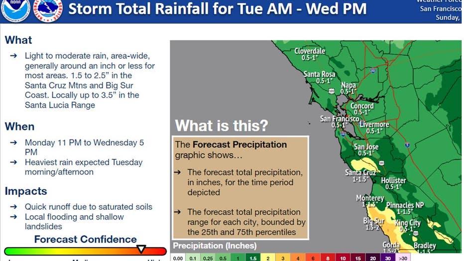
Rainfall:
Rainfall will be a secondary impact in our area behind the wind. The most intense rain is expected Tuesday morning and afternoon. The lower elevations of the North Bay, SF Bay Area, and Central Coast can expect:
.75 to 1.00" throughout the Bay Area. Lesser in parts of Sonoma County.
2.00 to 3.00" The Central Coast Mountains (Santa Lucia)
1.75 to 2.50" Santa Cruz, San Benito and interior Monterey Mountains
Thunderstorms:
Chance of thunderstorms with small hail with the post passage of the storm, (Tuesday afternoon, possibly Wednesday).
The combination of continued rain, high winds, and saturated soils poses a set of hazards now familiar to many to our area. It will not take much wind to cause more damage around the Bay Area.
Hazards:
- Minor Urban and Small Stream Flooding
- Landslides
- Down Trees
- Down Power lines
SEE ALSO: The water is higher than we need and the snowpack threatens
Record Snow:
As of Monday, according to the Central Sierra Snow Lab, more than 56.4 feet of snow has fallen, making it the second snowiest in the 77 years of record-keeping at the Lab, with more to come Tuesday and Wednesday.
Special Note:
With the passage of this storm, overnight lows dip into the low and mid 30s in the North Bay and East Bay wine country. The coldest night will be Saturday overnight low dropping to 31 degrees in Santa Rosa.
This is not good for the vineyards. From March to April the vines experience bud burst. From these buds, green leaves burst awake in preparation for photosynthesis with the warmer months. Bud break is a delicate time, as the new growth is in danger of spring frost and hail storms.