


Laney College to make security upgrades
This comes after the deadly shooting on campus of athletic director John Beam earlier this month.
This comes after the deadly shooting on campus of athletic director John Beam earlier this month.


Stimulus payment November 2025, IRS direct deposit relief payment & tariff dividend fact check
Don’t spend that money just yet! Rumors are circulating online that the federal government will issue new stimulus checks before the end of the year. But Congress has not passed any legislation authorizing payments, and the IRS has not confirmed that any new stimulus checks are scheduled in the coming weeks.
Don’t spend that money just yet! Rumors are circulating online that the federal government will issue new stimulus checks before the end of the year. But Congress has not passed any legislation authorizing payments, and the IRS has not confirmed that any new stimulus checks are scheduled in the coming weeks.

Presidential Turkey Pardons: Trump spares Waddle, Gobble in White House tradition
President Donald Trump kicked off Thanksgiving week with the classic White House tradition of pardoning turkeys.
President Donald Trump kicked off Thanksgiving week with the classic White House tradition of pardoning turkeys.

Richmond Police: a recent incident involving officers confronting teens with a replica gun is a wakeup call
Richmond Police provide new details about a video circulating on social media which shows officers with their guns drawn while interacting with teens down on the ground. Police say officers were responding to a call from a resident concerned that a group of teenage boys were handling what looked like a gun in front of her home.
Richmond Police provide new details about a video circulating on social media which shows officers with their guns drawn while interacting with teens down on the ground. Police say officers were responding to a call from a resident concerned that a group of teenage boys were handling what looked like a gun in front of her home.

Man receives 2 life sentences for brutal beating of "Grandma Huang"
A man found guilty of brutally beating an elderly Asian woman Yik Oi Huang, known as "Grandma Huang," and committing a string of other crimes in January 2019, including carjacking, burglary, robberies, and assaults, was sentenced by a judge Tuesday to 31 years, plus two consecutive life sentences. The Huang family said they were sad and angry that Keonte Gathron never apologized and refused to accept responsibility for the attacks.
A man found guilty of brutally beating an elderly Asian woman Yik Oi Huang, known as "Grandma Huang," and committing a string of other crimes in January 2019, including carjacking, burglary, robberies, and assaults, was sentenced by a judge Tuesday to 31 years, plus two consecutive life sentences. The Huang family said they were sad and angry that Keonte Gathron never apologized and refused to accept responsibility for the attacks.

San Jose Holiday Lights debuts at Discovery Meadow
The South Bay is welcoming a new seasonal attraction this year. San Jose Holiday Lights, a five-acre festival of glowing displays is now open at Discovery Meadow. The immersive walk-through experience features everything from classic holiday staples to dragons, dinosaurs and even Hello Kitty.
The South Bay is welcoming a new seasonal attraction this year. San Jose Holiday Lights, a five-acre festival of glowing displays is now open at Discovery Meadow. The immersive walk-through experience features everything from classic holiday staples to dragons, dinosaurs and even Hello Kitty.

Heavy Thanksgiving traffic expected Wednesday, Sunday
AAA warns that the Bay Area’s busiest travel days are Tuesday and Wednesday, with drivers facing extra heavy travel times and packed highways from San Francisco to Santa Rosa.
AAA warns that the Bay Area’s busiest travel days are Tuesday and Wednesday, with drivers facing extra heavy travel times and packed highways from San Francisco to Santa Rosa.

Berkeley police union holds Thanksgiving meal giveaway
Every year, the union representing Berkeley police officers sets out to feed families in the city.
Every year, the union representing Berkeley police officers sets out to feed families in the city.

Bodycam video shows aftermath of road rage shooting that killed child
Newly released body came video shows the moments after an 11-year-old boy was shot during a road-rage incident in Nevada.
Newly released body came video shows the moments after an 11-year-old boy was shot during a road-rage incident in Nevada.

Man in killing of San Francisco grandma faces life in prison
The man convicted in the deadly beating of a San Francisco grandmother faces life in prison.
The man convicted in the deadly beating of a San Francisco grandmother faces life in prison.

Native American Health Center gives community update
Anthony Guzman, chief cultural officer, at The Native American Health Center, gives update on new building and community services.
Anthony Guzman, chief cultural officer, at The Native American Health Center, gives update on new building and community services.

Laney College to see security upgrades after Coach Beam shooting
The Peralta Community College District is set to improve security on campus by the end of the year following the shooting death of beloved Coach John Beam on the Laney college campus.
The Peralta Community College District is set to improve security on campus by the end of the year following the shooting death of beloved Coach John Beam on the Laney college campus.

Remains found at Ocean Beach
Human remains were discovered Monday afternoon at San Francisco’s Ocean Beach, authorities said.
Human remains were discovered Monday afternoon at San Francisco’s Ocean Beach, authorities said.

Foster City man arrested in wife's cold case killing
Patrick Galvani was arraigned on Tuesday afternoon in San Mateo County Superior Court on one count of homicide. the 81-year-old is accused of killing his wife, Nancy in August of 1982. Her body was found in a sleeping bag floating in San Francisco Bay near the San Mateo-Hayward Bridge. If Galvani is convicted of all charges it would close a mystery that had haunted the community.
Patrick Galvani was arraigned on Tuesday afternoon in San Mateo County Superior Court on one count of homicide. the 81-year-old is accused of killing his wife, Nancy in August of 1982. Her body was found in a sleeping bag floating in San Francisco Bay near the San Mateo-Hayward Bridge. If Galvani is convicted of all charges it would close a mystery that had haunted the community.
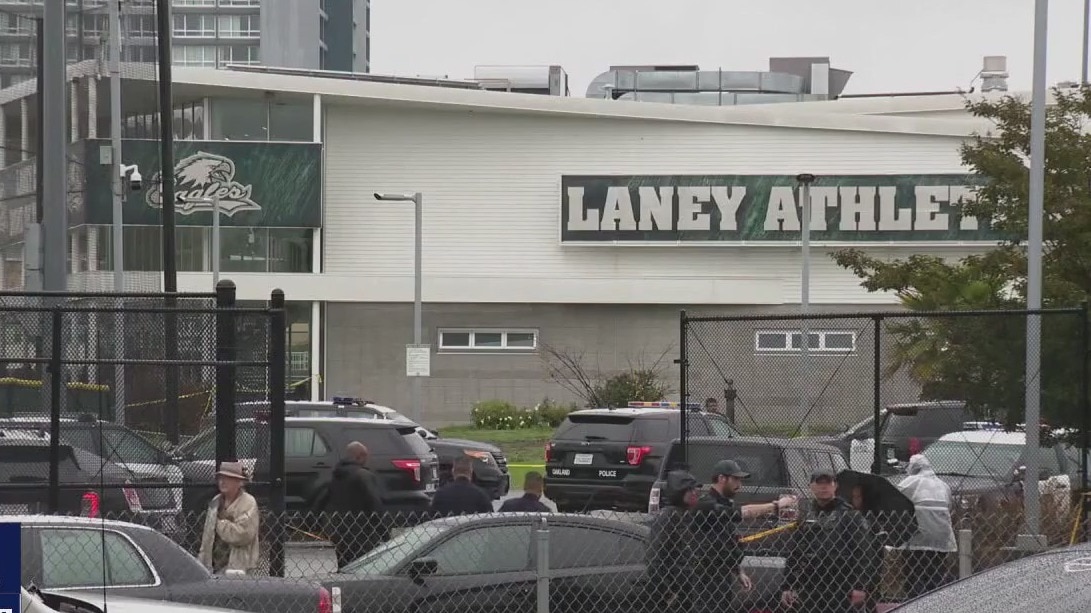
Laney College to see security improvements after Coach Beam shooting
Laney College's Field House will see $220,000 worth of security improvements early next year after shooting death of athletic director Coach John Beam.
Laney College's Field House will see $220,000 worth of security improvements early next year after shooting death of athletic director Coach John Beam.


Holiday dangers for dogs. How you can keep your pet safe this season
It’s that time of year marked with the hustle and bustle of the holidays, travel, special dinners and treats, house guests in and out, and a spike in respiratory illnesses. While all true for people, these are considerations for dogs too. Veterinarians in the Bay Area are offering ways to keep your furry family members healthy and safe.
It’s that time of year marked with the hustle and bustle of the holidays, travel, special dinners and treats, house guests in and out, and a spike in respiratory illnesses. While all true for people, these are considerations for dogs too. Veterinarians in the Bay Area are offering ways to keep your furry family members healthy and safe.

Missing Army solider swept out to sea off Big Sur coast
The search continued for a fourth day for a missing Army specialist who was swept out to sea off the coast of Big Sur.
The search continued for a fourth day for a missing Army specialist who was swept out to sea off the coast of Big Sur.

Dense fog returns Wednesday morning
We are expecting another round of dense fog for parts of the Bay Area Wednesday morning. A Spare the Alert (no wood burning) has been issued for Wednesday - Thursday. Highs should range from the upper 50s to the upper 60s. Your Thanksgiving forecast features scattered clouds. The warmest parts of the Bay Area. could approach 70.
We are expecting another round of dense fog for parts of the Bay Area Wednesday morning. A Spare the Alert (no wood burning) has been issued for Wednesday - Thursday. Highs should range from the upper 50s to the upper 60s. Your Thanksgiving forecast features scattered clouds. The warmest parts of the Bay Area. could approach 70.

'The Family Plan 2' Preview: Mark Wahlberg's new action-filled comedy
Mark Wahlberg and Michelle Monaghan discuss their new film "The Family Plan 2".
Mark Wahlberg and Michelle Monaghan discuss their new film "The Family Plan 2".

Hazardous materials found during Antioch arrest
A man charged with having child sexual abuse material was arrested in Antioch, where the discovery of chemicals and fireworks then led to a response by hazmat specialists and a bomb squad.
A man charged with having child sexual abuse material was arrested in Antioch, where the discovery of chemicals and fireworks then led to a response by hazmat specialists and a bomb squad.