


Willie Mays' personal collection on the auction block
Some of the most personal and historic items from Willie Mays' extraordinary career are up for auction at Hunt Auctions.
Some of the most personal and historic items from Willie Mays' extraordinary career are up for auction at Hunt Auctions.

TMZ releasing new documentary on the Reiner murders
Nearly one month after the murders of Rob and Michele Reiner, TMZ is releasing a new documentary on FOX Friday called, 'TMZ Investigates: The Reiner Murders: What Really Happend.' The special comes as new details emerge about their son Nick, who is accused of killing them, including fresh insight into his mental state in the weeks leading up to the murders.
Nearly one month after the murders of Rob and Michele Reiner, TMZ is releasing a new documentary on FOX Friday called, 'TMZ Investigates: The Reiner Murders: What Really Happend.' The special comes as new details emerge about their son Nick, who is accused of killing them, including fresh insight into his mental state in the weeks leading up to the murders.

Piedmont kids ride in 'bike-bus' format after bus line goes away
Piedmont kids ride in 'bike-bus' format after bus line goes away.
Piedmont kids ride in 'bike-bus' format after bus line goes away.

Oakland police arrest man in city's first homicide of 2026
Oakland police have arrested a man in connection with the city's first homicide of 2026.
Oakland police have arrested a man in connection with the city's first homicide of 2026.
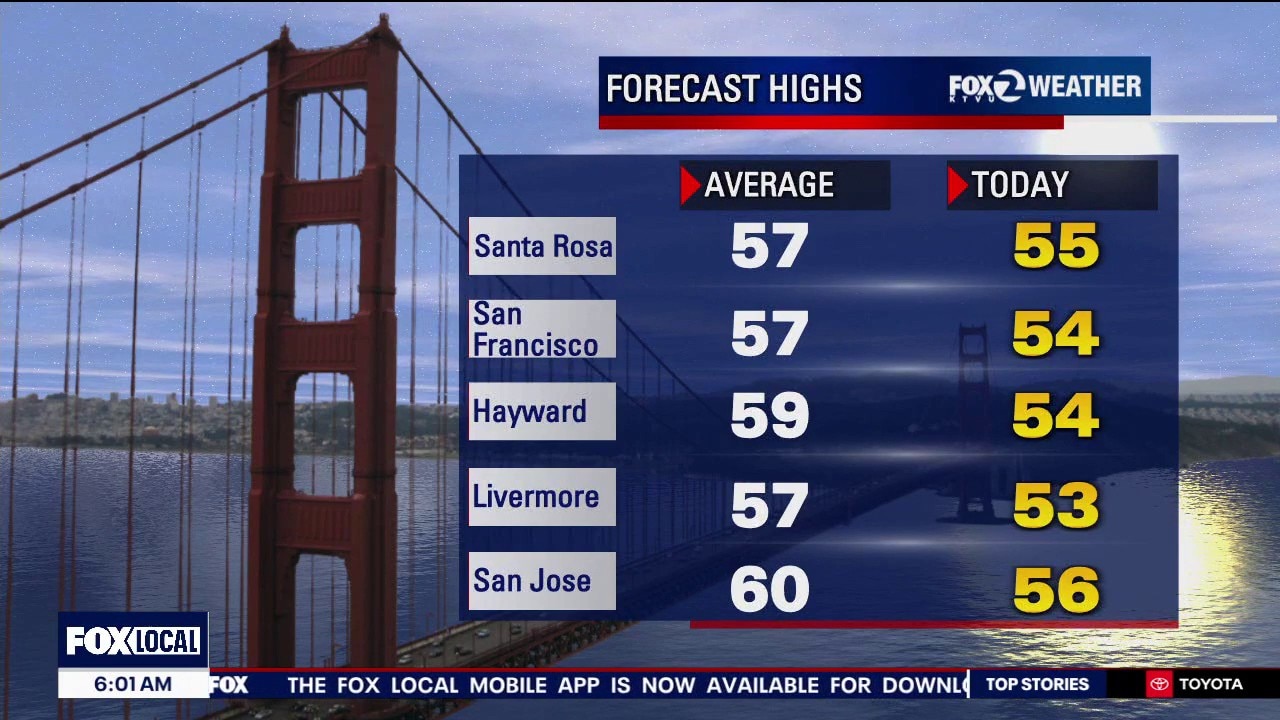
Low to mid 50s
Today's highs will be in the low to mid-50s.
Today's highs will be in the low to mid-50s.

Oakland vigil for missing woman
Family and friends hold a vigil for a missing woman in Reno with ties to Oakland.
Family and friends hold a vigil for a missing woman in Reno with ties to Oakland.

Bay Area man dies from suspected mushroom poisoning
Sonoma County has issued an urgent health warning regarding wild mushrooms, which are sprouting up across the entire Bay Area, posing extreme danger to people of all ages and their pets.
Sonoma County has issued an urgent health warning regarding wild mushrooms, which are sprouting up across the entire Bay Area, posing extreme danger to people of all ages and their pets.

Family of 80-year-old killed in SF hit-and-run pleads for driver to come forward
The family of an 80-year-man killed by a hit-and-run driver in San Francisco's Outer Mission said Thursday that they want justice but also want to forgive the suspect who is still at large.
The family of an 80-year-man killed by a hit-and-run driver in San Francisco's Outer Mission said Thursday that they want justice but also want to forgive the suspect who is still at large.

California drought status map
The latest drought status map update has all of California in the clear. The recent storms have been making a big difference. The drought map is issued every Thursday.
The latest drought status map update has all of California in the clear. The recent storms have been making a big difference. The drought map is issued every Thursday.

Chilly forecast
Our break from the rain continues. Cold air, moving in from the north, will set the stage for cold overnight temperatures Friday morning. The coldest neighborhoods will start the day in the low 30s. We are expecting full sunshine later in the day. Afternoon highs should warm into the 50s. The weekend remains dry. Fog may resurface in some of the inland valleys. Have a great weekend. Go 49ers! -Mark
Our break from the rain continues. Cold air, moving in from the north, will set the stage for cold overnight temperatures Friday morning. The coldest neighborhoods will start the day in the low 30s. We are expecting full sunshine later in the day. Afternoon highs should warm into the 50s. The weekend remains dry. Fog may resurface in some of the inland valleys. Have a great weekend. Go 49ers! -Mark


Bay Area immigrants' rights groups react to Minnesota ICE shooting
While the nation grapples with the shooting death of 37-year-old Renee Good at the hands of an ICE agent in Minneapolis, immigrant rights organizations in the Bay Area are reacting.
While the nation grapples with the shooting death of 37-year-old Renee Good at the hands of an ICE agent in Minneapolis, immigrant rights organizations in the Bay Area are reacting.

Bay Area immigrants' rights groups react to ICE shooting
Immigrant support groups in the Bay Area are reacting to the shooting death of Renee Good by an ICE officer in Minnesota this week.
Immigrant support groups in the Bay Area are reacting to the shooting death of Renee Good by an ICE officer in Minnesota this week.

Newsom punches back at critics in his final State of the State speech
California Gov. Gavin Newsom delivered his final State of the State address to lawmakers in Sacramento, declaring his state a blueprint for the rest of the nation and criticizing Republican President Donald Trump.
California Gov. Gavin Newsom delivered his final State of the State address to lawmakers in Sacramento, declaring his state a blueprint for the rest of the nation and criticizing Republican President Donald Trump.

Two Bay Area cities sued over natural gas ban
The cities of Morgan Hill and Petaluma are facing a lawsuit by the Trump administration over their decision to ban natural gas in most new buildings.
The cities of Morgan Hill and Petaluma are facing a lawsuit by the Trump administration over their decision to ban natural gas in most new buildings.


Son’s heartbreaking message to San Francisco driver who killed 80-year-old father
The family of an 80-year-old man killed in a hit-and-run crash in San Francisco’s Outer Mission neighborhood said Thursday they want justice but also offered forgiveness to the driver, who remains at large.
The family of an 80-year-old man killed in a hit-and-run crash in San Francisco’s Outer Mission neighborhood said Thursday they want justice but also offered forgiveness to the driver, who remains at large.

2 shot by federal agents in Portland
U.S. Customs and Border Protection were allegedly involved in a shooting that left two people injured in Portland, Oregon, on Thursday afternoon, according to the Federal Bureau of Investigation.
U.S. Customs and Border Protection were allegedly involved in a shooting that left two people injured in Portland, Oregon, on Thursday afternoon, according to the Federal Bureau of Investigation.

Minneapolis ICE shooting: Trump administration defends agent's actions
Vice President JD Vance says the ICE officer was clearly justified in shooting Good and he’s not worried about prejudging an investigation that is just getting underway.
Vice President JD Vance says the ICE officer was clearly justified in shooting Good and he’s not worried about prejudging an investigation that is just getting underway.

Minneapolis protesters clash with law enforcement after ICE agent kills woman
Minneapolis was on edge Thursday following the fatal shooting of a woman by a federal officer taking part in the Trump administration’s latest immigration crackdown, with protesters venting their outrage, the governor demanding that the state take part in the investigation and schools canceling classes as a precaution.
Minneapolis was on edge Thursday following the fatal shooting of a woman by a federal officer taking part in the Trump administration’s latest immigration crackdown, with protesters venting their outrage, the governor demanding that the state take part in the investigation and schools canceling classes as a precaution.

Google reveals top trending resolutions and how AI is playing a part in keeping them
We are on day 8 of the New Year, and so is the annual promise to "do better." Though, many have a tough time keeping their resolutions. However, there are new AI tools that are stepping in to help turn resolutions into real habits.
We are on day 8 of the New Year, and so is the annual promise to "do better." Though, many have a tough time keeping their resolutions. However, there are new AI tools that are stepping in to help turn resolutions into real habits.

Cost of youth sports continues to rise, study finds
The cost of youth sports is skyrocketing. A survey from the Aspen Institute found family spending on youth sports jumped 46% from 2019 to 2024, reaching an estimated $40 billion dollars a year.
The cost of youth sports is skyrocketing. A survey from the Aspen Institute found family spending on youth sports jumped 46% from 2019 to 2024, reaching an estimated $40 billion dollars a year.