

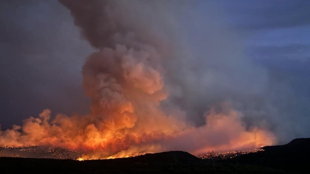

Man allegedly trying to cremate his dog sparks Colorado wildfire, officials say
The partially burned remains of a dog were found during officials' investigations into the cause of the fire.
The partially burned remains of a dog were found during officials' investigations into the cause of the fire.


Watch: FOX Weather meteorologist rescues woman from rising floodwaters in Atlanta
Van Dillen, a journalist from the Atlanta area, heard a woman's desperate cries for help during Hurricane Helene. She had driven into floodwaters and was trapped in her car before sunrise Friday.
Van Dillen, a journalist from the Atlanta area, heard a woman's desperate cries for help during Hurricane Helene. She had driven into floodwaters and was trapped in her car before sunrise Friday.


Warm to hot
Temps will be 70s at the coast and high 90s inland.
Temps will be 70s at the coast and high 90s inland.


Watch: Drone video from inside Hurricane Helene
A drone intentionally steered into Hurricane Helene in the eastern Gulf of Mexico took video of the strengthening cyclone in the hours before its was set to make landfall on Florida’s Gulf Coast.
A drone intentionally steered into Hurricane Helene in the eastern Gulf of Mexico took video of the strengthening cyclone in the hours before its was set to make landfall on Florida’s Gulf Coast.


WATCH: Amazing rescue of family with baby and dogs from rising floodwaters
Emergency crews in Atlanta rescued a family early Friday morning after their vehicle was swept off the road by swift floodwaters.
Emergency crews in Atlanta rescued a family early Friday morning after their vehicle was swept off the road by swift floodwaters.

FOX donates to Red Cross Hurricane Helene relief efforts: Here's how you can help
FOX has partnered with the American Red Cross to provide crucial support to those affected by Hurricane Helene. Learn how you can donate to help fund shelter, meals, and other recovery efforts.
FOX has partnered with the American Red Cross to provide crucial support to those affected by Hurricane Helene. Learn how you can donate to help fund shelter, meals, and other recovery efforts.


California's water supply outlook for the next 12 months
The new water year begins on October 1st and it comes on the on the heels of one of the hottest and driest summers on record. So, the California Department of Water Resources just briefed the media on expectations and preparations for the next 12 months. In fact, the DWR is masterful at managing water and it's getting better at looking into Mother Nature's weather crystal ball.
The new water year begins on October 1st and it comes on the on the heels of one of the hottest and driest summers on record. So, the California Department of Water Resources just briefed the media on expectations and preparations for the next 12 months. In fact, the DWR is masterful at managing water and it's getting better at looking into Mother Nature's weather crystal ball.

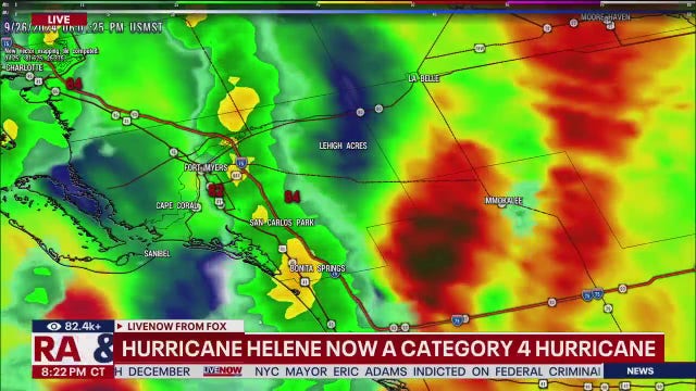
Hurricane Helene an 'extremely dangerous' Category 4 storm on track to Florida
Hurricane Helene has made landfall along Florida's Nature Coast.
Hurricane Helene has made landfall along Florida's Nature Coast.


Where does Helene go after hitting Florida? Southeast, mid-Atlantic could see 'catastrophic' flooding
The large storm will move quickly north, bringing widespread heavy rain, damaging winds and possible tornadoes to major cities in the Southeast and Midwest, including Atlanta, Nashville and St. Louis.
The large storm will move quickly north, bringing widespread heavy rain, damaging winds and possible tornadoes to major cities in the Southeast and Midwest, including Atlanta, Nashville and St. Louis.
Florida police give morbid advice to those who didn’t evacuate for Helene’s historic storm surge
The Taylor County Sheriff’s Office in the Big Bend of Florida is taking the dire step of asking residents who chose not to heed mandatory evacuation warnings for Hurricane Helene to write their name on their bodies in permanent marker.
The Taylor County Sheriff’s Office in the Big Bend of Florida is taking the dire step of asking residents who chose not to heed mandatory evacuation warnings for Hurricane Helene to write their name on their bodies in permanent marker.


Warming up again
A warming trend continues to highlight the Bay Area forecast. Mostly sunny skies are expected tomorrow. Highs should range from the low 70s near the coast to the upper 90s inland. We get a break from the heat this weekend. A warm to hot pattern returns early next week. Have a great Friday! -Mark
A warming trend continues to highlight the Bay Area forecast. Mostly sunny skies are expected tomorrow. Highs should range from the low 70s near the coast to the upper 90s inland. We get a break from the heat this weekend. A warm to hot pattern returns early next week. Have a great Friday! -Mark


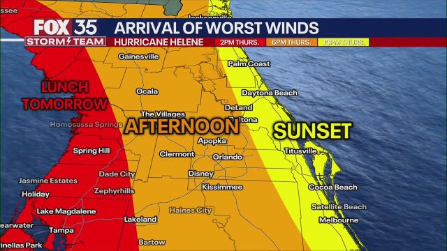
Flight disruptions impact Atlanta, Tampa as Hurricane Helene looms
The FOX Forecast Center expects the worst of the weather to be in the Atlanta metro from after midnight Friday morning through sunset.
The FOX Forecast Center expects the worst of the weather to be in the Atlanta metro from after midnight Friday morning through sunset.


Gray start, blue skies
Today will start off gray and foggy and clear off to blue skies. Temps in the 70s and 80s.
Today will start off gray and foggy and clear off to blue skies. Temps in the 70s and 80s.


Pleasanton dog likely dies of heat stroke
A dog left on a balcony in the heat Tuesday died before Pleasanton Animal Services could get to it.
A dog left on a balcony in the heat Tuesday died before Pleasanton Animal Services could get to it.


Warmer Thursday
After major temperature drop Wednesday, most of the Bay Area should warm slightly Thursday. The low clouds will move back in tonight. Partly sunny skies are expected tomorrow afternoon. Highs should range from the mid 60s near the coast to the upper 80s inland. The warming will peak in the Friday forecast.
After major temperature drop Wednesday, most of the Bay Area should warm slightly Thursday. The low clouds will move back in tonight. Partly sunny skies are expected tomorrow afternoon. Highs should range from the mid 60s near the coast to the upper 80s inland. The warming will peak in the Friday forecast.

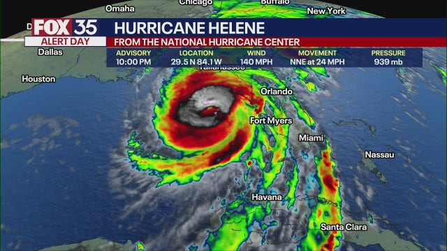
Live updates: Tropical Storm Helene nears hurricane strength in Caribbean on trek to Florida
Tropical Storm Helene is nearing hurricane strength just offshore of the northeastern coast of the Yucatan Peninsula toward the Gulf of Mexico, according to the National Hurricane Center (NHC). It's expected to become a major hurricane (Category 3 or higher) before making landfall in Florida's Big Bend region on Thursday.
Tropical Storm Helene is nearing hurricane strength just offshore of the northeastern coast of the Yucatan Peninsula toward the Gulf of Mexico, according to the National Hurricane Center (NHC). It's expected to become a major hurricane (Category 3 or higher) before making landfall in Florida's Big Bend region on Thursday.


Coolest day of the week
Today will be the coolest day of the week.
Today will be the coolest day of the week.


A Major Cooling Trend For Your Wednesday
Significant Cooling Trend Underway! Temperatures will be 10 to 15 degrees lower than todays. Fog and low clouds will cover all nine Bay Area Counties by Wednesday morning. High temperatures will be in the 70s and low 80s. Warmer weather for Thursday into the weekend. Have a great day! Bill
Significant Cooling Trend Underway! Temperatures will be 10 to 15 degrees lower than todays. Fog and low clouds will cover all nine Bay Area Counties by Wednesday morning. High temperatures will be in the 70s and low 80s. Warmer weather for Thursday into the weekend. Have a great day! Bill


Cooling on the way
Our recent hot stretch will be coming to an end. The inland Heat Advisory is set to expire at 8 pm today. You can expect a big blanket of clouds over the bay Wednesday morning. Partly sunny skies are expected later in the day. Highs should range from the low 60s near the coast to the mid 80s inland. Have a great Wednesday! -Mark
Our recent hot stretch will be coming to an end. The inland Heat Advisory is set to expire at 8 pm today. You can expect a big blanket of clouds over the bay Wednesday morning. Partly sunny skies are expected later in the day. Highs should range from the low 60s near the coast to the mid 80s inland. Have a great Wednesday! -Mark


Redwood City fire injures construction worker
Firefighters on Tuesday raced to put out a destructive fire in Redwood City that injured one construction worker and forced residents to flee their neighborhood choking on the thick smoke.
Firefighters on Tuesday raced to put out a destructive fire in Redwood City that injured one construction worker and forced residents to flee their neighborhood choking on the thick smoke.