


Chance of Wednesday showers
A cool weather system will drop in from north Wednesday. Partly to mostly cloudy skies are expected. We could also be tracking scattered showers.. Highs should range from the low 60s near the coast to the mid 70s inland. The extended forecast features more sunshine and warmer temperatures. Have a great Wednesday! -Mark
A cool weather system will drop in from north Wednesday. Partly to mostly cloudy skies are expected. We could also be tracking scattered showers.. Highs should range from the low 60s near the coast to the mid 70s inland. The extended forecast features more sunshine and warmer temperatures. Have a great Wednesday! -Mark


Fog, sun, breezy
Today will see fog then sun. Breezy, cooler conditions.
Today will see fog then sun. Breezy, cooler conditions.


Chance of rain this week with some mild days
Tuesday is expected to be mostly sunny with some clouds throughout the day. High temperatures will be mild, typically ranging from the mid-60s to mid-70s, with the warmest areas reaching the upper 70s. On Wednesday, cloud cover will increase, bringing a good chance of light showers. These showers may result in some accumulation, particularly in the coastal hills of the North Bay and South Bay. The Sierra Nevada could see a bit of snow at elevations above 8,000 feet, while Northern California may experience rain amounts ranging from a quarter inch to potentially half an inch.
Tuesday is expected to be mostly sunny with some clouds throughout the day. High temperatures will be mild, typically ranging from the mid-60s to mid-70s, with the warmest areas reaching the upper 70s. On Wednesday, cloud cover will increase, bringing a good chance of light showers. These showers may result in some accumulation, particularly in the coastal hills of the North Bay and South Bay. The Sierra Nevada could see a bit of snow at elevations above 8,000 feet, while Northern California may experience rain amounts ranging from a quarter inch to potentially half an inch.


Partly cloudy, dry and mild for Tuesday
Morning clouds will break away to a mix of sun and clouds for the afternoon with highs ranging from 60s at the coast to mid 70s inland. Another chance for rain arrives on Wednesday.
Morning clouds will break away to a mix of sun and clouds for the afternoon with highs ranging from 60s at the coast to mid 70s inland. Another chance for rain arrives on Wednesday.


BART's Transbay Tube celebrates 50th anniversary, earthquake retrofit complete
The BART Transbay Tunnel celebrated its 50th birthday on Monday with a very special announcement about its resilience to mega earthquakes going forward far, far into the future. The 50-old infrastructure is now fully ready for the next half-century, perhaps the next millennium.
The BART Transbay Tunnel celebrated its 50th birthday on Monday with a very special announcement about its resilience to mega earthquakes going forward far, far into the future. The 50-old infrastructure is now fully ready for the next half-century, perhaps the next millennium.


Clouds, cool
Today will see clouds and temps will be cooler in the 60s and 70s.
Today will see clouds and temps will be cooler in the 60s and 70s.


Cooler, chance of rain
A cooling trend is expected to persist across the Bay Area. Temperatures will likely remain below average, generally hovering in the mid to low 70s. There is also a possibility of showers on Monday and again on Wednesday. Overall, temperatures are not expected to warm up significantly, with overnight lows in the 50s and daytime highs in the 70s for the remainder of the week. Additionally, patchy fog may affect the coastal regions.
A cooling trend is expected to persist across the Bay Area. Temperatures will likely remain below average, generally hovering in the mid to low 70s. There is also a possibility of showers on Monday and again on Wednesday. Overall, temperatures are not expected to warm up significantly, with overnight lows in the 50s and daytime highs in the 70s for the remainder of the week. Additionally, patchy fog may affect the coastal regions.


Yosemite National Park areas to see measurable snow early this week
Snow levels will drop to 8,000 feet, likely bringing measurable snow to parts of the Sierra Nevada.
Snow levels will drop to 8,000 feet, likely bringing measurable snow to parts of the Sierra Nevada.


Partly cloudy, cool, breezy, light showers
An early season system will bring a cloudier, cooler, breezy day to the bay area with the possibility of light showers and a slight risk of thunderstorms tonight into tomorrow. Afternoon highs will range from low 60s at the coast to low 70s inland.
An early season system will bring a cloudier, cooler, breezy day to the bay area with the possibility of light showers and a slight risk of thunderstorms tonight into tomorrow. Afternoon highs will range from low 60s at the coast to low 70s inland.


Cooler pattern
Our cooling trend continues! Your Sunday forecast features partly to mostly cloudy skies. Winds will be increasing during the afternoon. Gusts could approach 40 mph. Highs should range from the low 60s near the coast to the mid 70s inland. A system will drop into Northern California Monday. Shower chances have been added to the forecast. Projected rainfall amounts range from just a trace to .25" in the hills. Have a great Sunday! -Mark
Our cooling trend continues! Your Sunday forecast features partly to mostly cloudy skies. Winds will be increasing during the afternoon. Gusts could approach 40 mph. Highs should range from the low 60s near the coast to the mid 70s inland. A system will drop into Northern California Monday. Shower chances have been added to the forecast. Projected rainfall amounts range from just a trace to .25" in the hills. Have a great Sunday! -Mark


A subtle cool down underway today
A cooler day is shaping up around the bay area today with afternoon highs ranging from mid 60s on the coast to upper 80s inland. Cloudier, cooler, breezy for Sunday with a few showers and a risk of thunderstorms expected late Sunday into Monday.
A cooler day is shaping up around the bay area today with afternoon highs ranging from mid 60s on the coast to upper 80s inland. Cloudier, cooler, breezy for Sunday with a few showers and a risk of thunderstorms expected late Sunday into Monday.


Cooler weekend
The low clouds will bulk up in coverage Saturday morning. Partly sunny skies are expected later in the day. Our cooling trend begins! Highs should range from the mid 60s near the coast to the upper 80s inland. The real cooling moves in Sunday. Winds will be increasing too. Gusts could approach 35 mph. A cooler system could also produce some showers by Monday morning! Enjoy the cooler weekend! -Mark
The low clouds will bulk up in coverage Saturday morning. Partly sunny skies are expected later in the day. Our cooling trend begins! Highs should range from the mid 60s near the coast to the upper 80s inland. The real cooling moves in Sunday. Winds will be increasing too. Gusts could approach 35 mph. A cooler system could also produce some showers by Monday morning! Enjoy the cooler weekend! -Mark


Trump says he'd withhold federal aid for California wildfires if elected, insults Newsom
Former President Donald Trump held a news conference in Los Angeles where he said if he's elected, he would withhold federal aid for California wildfires if Governor Gavin Newsom doesn't change his water policy.
Former President Donald Trump held a news conference in Los Angeles where he said if he's elected, he would withhold federal aid for California wildfires if Governor Gavin Newsom doesn't change his water policy.


Cooler weekend forecast
Temperatures will cool this weekend. We are tracking the chance of showers Monday.
Temperatures will cool this weekend. We are tracking the chance of showers Monday.


3.4 earthquake shakes up South Bay
A 3.4 earthquake rocked some parts of the South Bay, reaching a 3.4 on the Ritcher scale.
A 3.4 earthquake rocked some parts of the South Bay, reaching a 3.4 on the Ritcher scale.


Temps slightly above average
Today's temps will be slightly above average.
Today's temps will be slightly above average.


Another pleasant day in the Bay Area, but a cooler weekend ahead
Another pleasant day in the Bay Area on Thursday. Friday will be great too, before temperatures with dip a bit on Saturday.
Another pleasant day in the Bay Area on Thursday. Friday will be great too, before temperatures with dip a bit on Saturday.


Warm Thursday
The Thursday morning clouds will continue to clear out this afternoon. After a chilly start today, plan on mild to warm conditions this afternoon. Highs should range from the mid 60s near the coast to the upper 80s inland. Warming continues tomorrow. A cooler pattern will move in this weekend. Have a great day! -Mark
The Thursday morning clouds will continue to clear out this afternoon. After a chilly start today, plan on mild to warm conditions this afternoon. Highs should range from the mid 60s near the coast to the upper 80s inland. Warming continues tomorrow. A cooler pattern will move in this weekend. Have a great day! -Mark
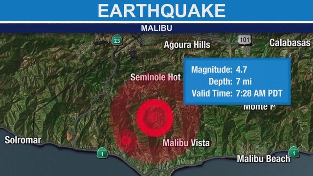

Earthquake centered in Malibu rattles Southern California
The earthquake was centered about four miles north of Malibu.
The earthquake was centered about four miles north of Malibu.


Earthquake strikes during live taping of Good Day LA
The Good Day LA cameras were rolling when an earthquake struck Southern California on Thursday. Watch the anchors react.
The Good Day LA cameras were rolling when an earthquake struck Southern California on Thursday. Watch the anchors react.