

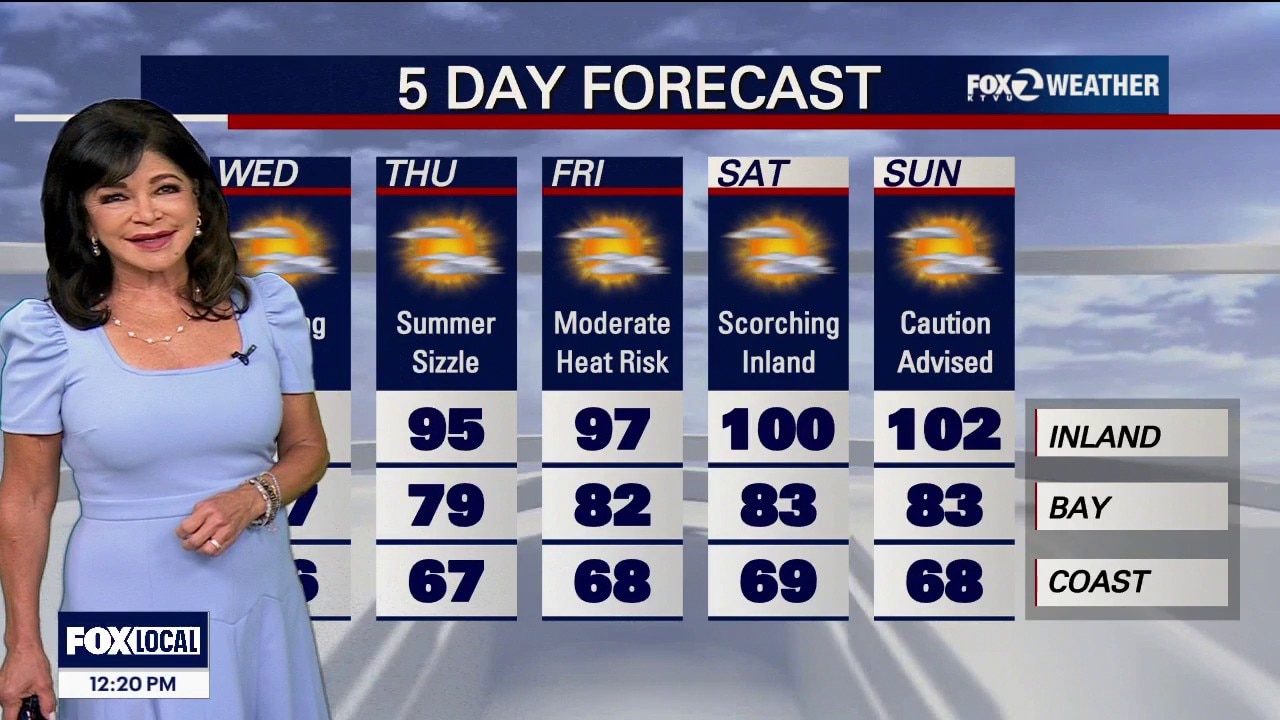
August is coming in HOT
• Wave 1: This Weekend (Thursday – Sunday): High pressure will build aggressively westward starting tomorrow, compressing the marine layer.. ◦ The Numbers: Saturday inland downright hot, easily cracking 100 - 102.. ◦ Heat Risk: Widespread Moderate Heat Risk will lock over our inland neighborhoods Thursday through Sunday night.. ◦ The Coast Shield: Strong northwest winds blowing over the ocean this weekend will trigger cold water upwelling. This will enhance a stubborn, narrow marine cloud block, keeping beaches highly comfortable in the 60s and 70s while inland valleys bake.. • Wave 2: Next Week (August 5 – August 8 Watch): The Climate Prediction Center (CPC) is tracking an even more alarming pattern as the ridge will rebuild massively by next Tuesday, flashing high-confidence signals for another round of even hotter, extreme temperatures toward the end of next week.. Critical Fire Weather Alert (Elevated All Week) • The Threat: An elevated fire weather threat remains active across the interior North Bay, East Bay, Diablo Range, and Santa Lucia Range.. • The Ridge Factor: While lower valleys will benefit from good overnight cooling, the higher elevations will suffer. Mountain ridges and peaks will struggle to cool down at night, trapping bone-dry air and keeping temperatures warm with near-zero humidity recovery. Avoid any sparks, campfires, or outdoor equipment use. Beach Warning Active • Sneaker Wave Alert: The Beach Hazards Statement is locked in through the weekend. Deceptive, long-period southerly ocean swells are generating dangerous rip currents and sudden sneaker waves along the Pacific Coast. Stay off wet coastal rocks and jetties..
Top Videos
August is coming in HOT

Earthquake swarm strikes South Bay

CHP begins Thanksgiving holiday enforcement

Black Friday deals curbed by tariff-driven costs

Navigating holiday travel as a non-citizen

Laney College to make security upgrades

Officers detain teens with BB gun

Man receives 2 life sentences for brutal beating of "Grandma Huang"

Foster City man arrested in wife's cold case killing

Celebrating Native Culture: Oakland's Intertribal Friendship House

Older drivers' confidence plummets around age 70
Most Watched

Trump-Zelenskyy Oval Office confrontation

Woman sought after kicking dog in Pittsburg

Patient files lawsuit Kaiser Permanente, alleges sexual assault during surgery

Trump marks 30 days in Oval Office | West Coast Wrap

Gas prices climb in California while they fall in other states

Hundreds of NOAA scientists fired

Arrests and guns seized in probe of Oakland carjacking tied to pot dispensaries

Protesters work to disrupt ICE raid | West Coast Wrap

San Jose teen killed by alleged gang members for wearing red


