

Flash flood watch in effect as thunderstorms threaten Southern California
(My Fox LA) -- Southland residents will have more warm and humid weather Thursday, with a chance of thunderstorms and possible flooding -- particularly in the mountains and Antelope Valley.
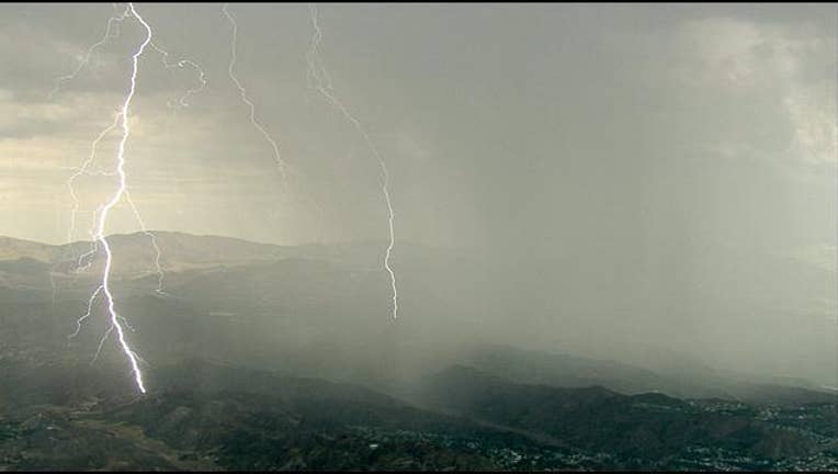
SkyFOX captured an incredible shot of lightening over the Acton area Thursday morning with bolts from cloud to ground.
RELATED: Unpredictable Monsoon Weather & High Heat Grips The Southland
RELATED: Drought Watch: Staying Cool in the Excessive Heat
Some rain fell Thursday morning in select Southern California areas as the sticky weather remained settled over the area, and the National Weather Service issued a flash flood watch for the mountains, Antelope and San Gabriel valleys.
"A significant surge of monsoonal moisture combined with an upper-level disturbance and instability will bring a threat of showers and thunderstorms
to the region today into tonight," according to the National Weather Service. "The threat of thunderstorms will begin across Los Angeles County this
morning, then spread into Ventura and Santa Barbara counties late this morning."
Forecasters noted that "due to the deep moisture in place," any storms that develop could bring heavy rainfall and raise the danger of flooding.
According to the NWS, the best chances for storms will be over the mountains and deserts, "but there will even be the possibility of thunderstorms over coastal and coastal valley areas."
"In the mountains and deserts, the storms could be intense enough to generate flash flooding," according to the Weather Service. "Mud and debris
flows are possible near the recent burn area, including the Colby and Pine burn areas."
Glendora city officials were monitoring the forecast near the Colby fire burn area, but they did not immediately impose any parking or other restrictions -- although they warned residents of the possibility of heavy rain. The city typically will raise its alert level to "yellow" if there is a threat of significant rainfall. The alert requires residents to remove vehicles and other large objects from streets to protect them from flooding and mud flows, and to ensure access for emergency crews.
Although the alert level had not been raised as of about midday, forecasters said any storms that develop in the San Gabriel Valley area could
bring up to 1 to 2 inches per hour of rain.
The threat of showers and thunderstorms will continue into early next week, forecasters said, including a "slight chance of afternoon and evening
thunderstorms across the mountains of Los Angeles County and the Antelope Valley Sunday."
Temperatures are expected to range from the mid- to upper-70s at the beaches today, rising to the upper-80s inland and hitting the 90s in the
valleys.
Copyright 2015 FOX 11 Los Angeles : Download our mobile app for breaking news alerts or to watch FOX 11 News | Follow us on Facebook, Twitter and YouTube.