

SCU Lightning Complex Fire expands to 157,475 acres
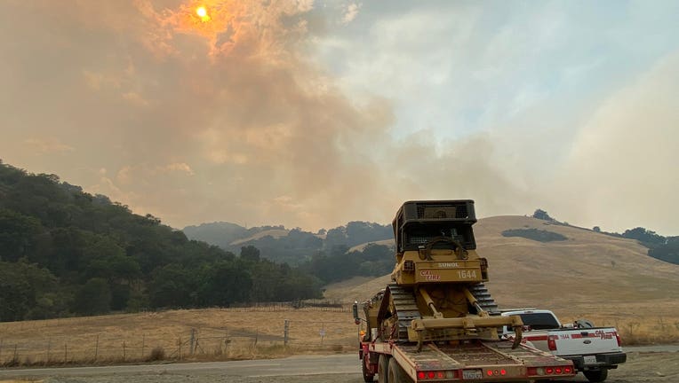
Group of fires near the Sunol Regional Wilderness and the Calaveras Reservoir have burned more than 1,700 acres and still had zero containment as of Aug. 17, 2020, according to Cal Fire. (Alameda County Fire Department)
The SCU Lightning Complex Fire, which stretches across parts of Santa Clara, Alameda, Contra Costa, San Joaquin and Stanislaus counties, has grown to 157,475 acres, Cal Fire announced Thursday evening.
Firefighters have established 5% containment against the fire.
There are about 20 fires in this group that are divided into three zones, the Canyon Zone, the Calaveras Zone, and the Deer Zone.
"The fires continue to burn in steep, rugged terrain and are influenced by extreme temperatures, and low relative humidity," Cal Fire said.
RELATED: California's oldest state park, Big Basin, suffers extensive fire damage
Two people have been injured, Cal Fire said, but no structures have been damaged.
Footage released by firefighters from San Luis Obispo, who are helping combat the fire, shows flames near a home on Mt. Hamilton.
EVACUATION ORDERS:
Alameda County / Stanislaus County
- Frank Raines Park to Mines Road
- Del Puerto Canyon Road 1 mile to Mines Road
Alameda County
- All of Mines Road, south of Mile Marker 10 to the county line
San Joaquin County
- South of West Corral Hollow Road to Stanislaus County line
- West of I-580 to Alameda County line
- East of Alameda County line to I-580 and the Stanislaus County line
Santa Clara County
- East of San Jose City limits
- South of Mt. Hamilton Rd.
- North of Metcalf Rd. & San Felipe Rd., East to the County Line
- East of San Antonio Valley Rd. to Del Puerto Canyon Rd. to the County Line
- South of Stanislaus County Between Santa Clara County Line and I-5
- West of I-5 North of Stanislaus/Merced County Line
- North of Stanislaus/Merced County Line
- East of Santa Clara County Line
- North of Hwy 130 to Santa Clara County Line
- West of San Antonio Valley Rd.
- West of Mines Rd. to Santa Clara County Line
- East of 3 Springs Rd. and Mt. Hamilton Rd.
- South of Santa Clara County Line
- North of Mt. Hamilton Rd. to Three Springs Rd.
- South of Santa Clara County Line
- West of the Fire Perimeter
- East of Ferguson Rd. East and North of Hwy 15
- West of Merced County Line
- North of Hwy 152
- South of Metcalf Rd at Shingle Valley Rd.
- East to the Stanislaus County line
- East of Shingle Valley Rd. and everything East of Anderson Lake, East of Coyote Creek,
- East of Coyote Reservoir, East of Roop Rd., East of Leavesley Rd., East of Crews Rd.,
- East of Ferguson Road.
- East and North of Hwy 152
- West of Merced County Line, North of Hwy 152
- South of Metcalf Road at Shingle Valley Road, East to the Stanislaus County Line
EVACUATION WARNINGS:
Alameda County
- City of Fremont - Mill Creek Road
San Joquin County
- All of PAR Estates which are the following streets:
- W. Vernalis Road, Bernard Drive, Stearman Road, Brichetto Court, Stearman Court, S Chrisman Road south of I-580, and the Tracy Golf & Country Club
- North of West Corral Hollow Road to I-580
- East of the Alameda County line to I-580
Stanislaus County
- South of Diablo Grande Parkway and the Diablo Community to the Stanislaus/Merced County Line
- West of the I-5
- North of Stanislaus/Merced County Line
- East of Santa Clara County Line
Santa Clara County
- South of Metcalf Rd. East of Coyote Creek to the Anderson Lake Shore, East of Chochrane Rd., East of Hill Rd. and South of Main Ave., North of Maple Ave., East of Foothill Ave, North of San Martin Ave, East of New Ave..
- West of Shingle Valley Rd. and everything West of Anderson Lake, West of Coyote Creek, West of Coyote Reservoir, North and West of Roop Rd. between Coyote Reservoir Rd. and New Ave
- East of Lovers Lane and the Santa Clara County
- South of Hwy 152 to the San Benito County line
- West to the Merced County Line
- North of San Benito County Line to Hwy 152
EVaCUATION CENTERS:
- Creekside Middle School: 535 Peregrine Dr, Patterson, CA 95363
- Milpitas Library: 160 N Main St Milpitas, CA 95035
ROAD CLOSURES:
- Holiday Dr. at East Dunne Ave., Coyote Reservoir Rd. at Roop Rd., Canada Rd. at Hwy 152, Hwy 152 at Belle Station
- Del Puerto Canyon Road (SR-130) between Mines Road and Diablo Grande PKWY
- Hwy 130 at Three Springs Rd.
- Hwy 130 at Quimby Rd.
ANIMAL EVACUATION CENTERS
- County of Santa Clara Animal Services: (408 )686-3900 For the unincorporated areas of Santa Clara County, Morgan Hill, and Gilroy
- Hold Your Horses Live Stock: (925)-584-1976 Large Animals in Canyon Fire area