

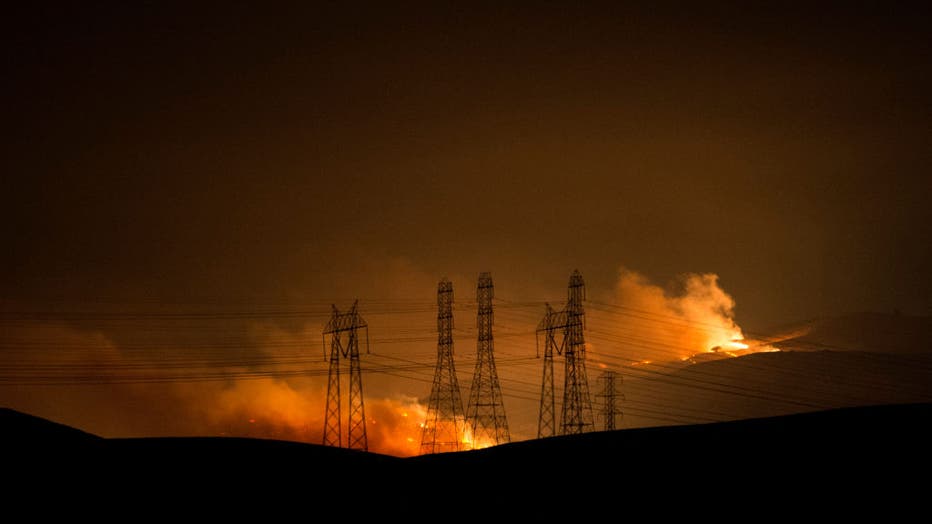
SCU Lightning Complex Fire: First responder injured, 360,055 acres burned

SCU Lightning Complex Fire scorches 542 square miles
SCU Lightning Complex Fire scorches 542 square miles. Claudine Wong reports
LIVERMORE, Calif. - A first responder was injured fighting the SCU Lightning Complex Fire, Cal Fire officials said Monday, bringing the total of first responder injuries to three.
In addition, Cal Fire said 360,055 acres burned across seven counties, including Alameda, Contra Costa and Santa Clara counties, and had the blazes 15% contained.
About two dozen structures have been destroyed and 20,065 remain threatened.
Of all the major fires raging in California, the SCU fires comprise the second-largest complex.

Nearly 350,000 acres burn in SCU Lightning Complex Fire
As one Cal Fire Chief put it, fighting these fires is still a marathon with a long way to go. In that regard, Cal Fire says it got lucky Sunday night on the SCU fire, very lucky.
As one Cal Fire chief put it, fighting these fires is still a marathon with a long way to go. In that regard, the fire agency said it got lucky Sunday night on the SCU fire.
"We were actually aided by the fact lightning strikes did not come in that we expected to yesterday; only having started one additional fire last night," said Cal Fire Operations Section Chief Tim Ernst.
But the fire remains a monster as it grows in two dangerous directions.
"Our number one priority for this fire will remain this entire western front along what we call the Calaveras Zone," said Ernst. That's where the majority of the threatened structures are.
"A large part of our priority right now is to stop ant further southerly movement of the fire," said Ernst.
On a 72-mile drive from Patterson in Stanislaus County along Del Puerto Canyon Road and Mines Road to Livermore, crossing a major southern portion of the SCU Fire footprint, much of what we saw was scorched earth of an extremely sparsely populated mountain wilderness.
However, we were somewhat surprised to see a number of still standing homes and structures that had a lot of well trimmed and clean areas surrounding them. Out buildings, not so well cared for, were taken by the flames.
We also saw remnants of the fire fight that went on here, such as a track of retardant laid down by an air tanker. Because folks on Del Puerto Road take defensive space very seriously and the firefighters did a heck of a job defending property, it looks like some of those folks, at least, are going to have homes to go home to.
The popular Frank Raines Off Road Park, remained mostly intact, with the children's playground untouched, but the park did suffer the loss of the ranger's home, a barn and a small cottage
We frequently encountered groups of fire trucks standing by to go on patrol for hotspots. Other crews plied the steep and rugged terrain to put any hotspots out. In one case, a southern California crew from Torrance used their waiting time and location to take rope and repel training. There can never be too much training.
"We are essentially living in a mega fire era," said Cal Fire Santa Clara Unit Chief Jake Hess. And, says Chief Hess, evacuations will come earlier, "We're gonna have to evacuate people more often and more people."
The traditionally two worst months of fire season is still ahead of us: September and October.
TRACY, CA - AUGUST 18: Part of the SCU Lightning Complex Incident wildland fire burns in the hills near Corral Hollow Road in San Joaquin County between Tracy and Livermore, Calif., on Tuesday, Aug. 18, 2020. (Photo by Doug Duran/MediaNews Group/East
Interactive map: See where wildfires are burning across the Bay Area
CZU August Lighting Complex Fire: No imminent danger to Santa Cruz or UC campus
70-year-old man found dead; wildfires rage through Northern California
California inmates battling wildfires despite COVID-19, early releases
'Sickening': Firefighter has wallet stolen, bank account drained during Santa Cruz firefight
As of 5 p.m. on Monday, Zone 4B in Santa Clara County was reduced from an evacuation order to a warning. (See the SCU Lightning Complex Fire evacuation map)
Evacuations Orders: Santa Clara County:(8/20/20 3:00 PM)
East of Shingle Valley Rd. and everything East of Anderson Lake, East of Coyote Creek, East of Coyote
Reservoir, East of Roop Rd., East of Leavesley Rd., East of Crews Rd., East of Ferguson Road.
East and North of Hwy 152
West of Merced County Line, North of Hwy 152
South of Metcalf Road at Shingle Valley Road, East to the Stanislaus County Line Alameda County /
(8/19/20 9:45 PM)
East of San Jose City limits
South of Mt. Hamilton Rd.
North of Metcalf Rd. & San Felipe
East of San Antonio Valley Rd. to Del Puerto Canyon Rd. to the County Line
(8/19/20 9:00 PM)
South of Stanislaus County Between Santa Clara County Line and I-5
West of I-5 North of Stanislaus/Merced County Line
North of Stanislaus/Merced County Line
East of Santa Clara County Line, East if Ed Levine County Park, Felter Rd., Sierra Rd., East of San Antonio Valley Rd. to Del Puerto Canyon Rd. to the County Line Toyon Ave., and
Mt. Hamilton Rd. to Three Springs Rd.
(8/18/20 10:00 PM)
North of Hwy 130 to Santa Clara County Line
West of San Antonio Valley Rd.
West of Mines Rd. to Santa Clara County Line
East of 3 Springs Rd. and Mt. Hamilton Rd.
South of Santa Clara County Line
North of Mt. Hamilton Rd. to Three Springs Rd.
South of Santa Clara County Line
West of the Fire Perimeter
East of Ferguson Rd. East and North of Hwy 152
Evacuations Orders: Alameda County
(8/23/20 3:00 AM)
South of Welch Creek Rd. to the fire perimeter and the Alameda/Santa Clara County Line
East of Calaveras Rd. at Welch Creek Rd. to the fire perimeter
(8/19/20 4:00 PM)
All of Mines Road, south of Mile Marker 10 to the County line
Evacuations Orders: Alameda / Stanislaus County
(8/18/20 8:00 PM)
Frank Raines Park to Mines Road
Del Puerto Canyon Road 1 mile to Mines Road Alameda County San Joaquin County:
(8/20/20 12:00 PM)
South of West Corral Hollow Road to Stanislaus County line
West of I-580 to Alameda County line
East of Alameda County line to I-580 and the Stanislaus County line
The PAR Estates and following streets are excluded from the order, but will be in an evacuation warning: (See warning below) Evacuation Warnings: (8/20/20 12PM) San Joaquin County:
All of PAR Estates which are the following streets: W. Vernalis Road, Bernard Drive, Stearman Road, Brichetto Court, Stearman Court, S
Chrisman Road south of I-580, and the Tracy Golf & Country Club
North of West Corral Hollow Road to I-580
East of the Alameda County line to I-580 Stanislaus County:
(8/20/20 2PM) Alameda County: Diablo Grande Parkway and the Diablo Grande Community Alameda County
(8/18/20 7AM) Alameda County: City of Fremont - Mill Creek Road
(8/22/20 6 PM) Stanislaus County:
East of the Mission Blvd. and Mission Rd. Intersection south to the Intersection of Mission Blvd and Curtner Rd.
East of Curtner Rd. south along I-680 to the Santa Clara County Line
South of I-580 in between Greenville Rd. and San Joaquin County Line to the Alameda/Santa Clara County Line, South of the Livermore City limits (excluding the cities of Livermore and Pleasanton), South of Hwy 84 in between Vineyard Ave. and I-680, South of I-680 to the fire perimeter and the Alameda/Santa Clara County Line West of the Alameda/San Joaquin County Line to the Livermore city limits, to Hwy 84 to I-680
North of fire perimeter and the Alameda/Santa Clara County Line to Hwy 84, to the Livermore city limits, to I-580 Santa Clara County:
(8/20/20 3 PM) Santa Clara County:
South of Metcalf Rd. East of Coyote Creek to the Anderson Lake Shore, East of Chochrane Rd., East of Hill Rd. and South of Main Ave., North of Maple Ave., East of Foothill Ave, North of San Martin Ave, East of New Ave.
(8/20/20 3 PM) Santa Clara County:
West of Shingle Valley Rd. and everything West of Anderson Lake, West of Coyote Creek, West of Coyote Reservoir, North and West of Roop Rd. between Coyote Reservoir Rd. and New Ave.
(8/20/20 4 PM) Santa Clara County:
East of Lovers Lane and the Santa Clara County South of Hwy 152 to the San Benito County line West to the Merced County Line North of San Benito County Line to Hwy 152 Merced County: North of Hwy 152 to I-5 to the Santa Clara County Line and Stanislaus
(8/23/20 3 PM) Santa Clara County:
South of Dunne Ave. and West of Lower Thomas Grade, East of Hill Rd., North of Maple Ave., Foothill Ave., North San Martin Ave., East of New Ave. North of Roop Rd., West of Coyote Creek and Coyote Lak
(8/21/20 3 PM) Merced County:
North of Hwy 152 to I-5 to the Santa Clara County Line and Stanislaus County Line West of the I-5 EXCLUDING THE COMMUNITY OF SANTA NELLA East of Santa Clara County Line and Stanislaus County Line to the Delta-Mendota South of the Stanislaus County Line to Hwy 152
Temporary Evacuation Points:
Creekside Middle School: 535 Peregrine Dr, Patterson, CA 95363
Milpitas Library: 160 N Main St Milpitas, CA 95035
Ann Sobrato High School – Performing Arts Building: 401 Burnett Ave. Morgan Hill, CA 95037
Road Closures:
Holiday Dr. at East Dunne Ave., Coyote Reservoir Rd. at Roop Rd., Canada Rd. at Hwy 152, Hwy 152 at Belle Station
Del Puerto Canyon Road (SR-130) between Mines Road and Diablo Grande PKWY
Hwy 130 at Three Springs Rd.
Hwy 130 at Quimby Rd.
Animal Evacuation Points:
County of Santa Clara Animal Services: (408)686-3900
For the unincorporated areas of Santa Clara County, Morgan Hill, and Gilroy
Hold Your Horses Livestock: (925)584-1976
Large Animals in Canyon Zone
Alameda County Animal Services: (925)803-7041
Large and Small animal shelter and assistance
Large and Small animal shelter and assistance