


Record heat
Today should see record heat in the 80s.
Today should see record heat in the 80s.


A significant warm up on the way
Mother nature turning up the heat for your Bay Area Sunday. Temperatures will range from low 60s at the coat to mid 70s inland under mostly sunny skies. Elevated pollen levels could kick up seasonal allergies. The warming trend will continue for the start of the week with record breaking heat possible on Monday and Tuesday. Enjoy ~ Rosemary
Mother nature turning up the heat for your Bay Area Sunday. Temperatures will range from low 60s at the coat to mid 70s inland under mostly sunny skies. Elevated pollen levels could kick up seasonal allergies. The warming trend will continue for the start of the week with record breaking heat possible on Monday and Tuesday. Enjoy ~ Rosemary


Warming up
A significant warming trend will be moving into the Bay Area!. Patchy low clouds will resurface Sunday morning. Mostly sunny skies and warmer temperatures will highlight the afternoon forecast. Highs should range from the mid 60s to the mid 70s. The warming will continue into early next week! By Monday, the warmest parts of the Bay Area will approach the mid 80s! Temperatures will be a good 10 to 15 degrees above normal. Have a great Sunday! -Mark
A significant warming trend will be moving into the Bay Area!. Patchy low clouds will resurface Sunday morning. Mostly sunny skies and warmer temperatures will highlight the afternoon forecast. Highs should range from the mid 60s to the mid 70s. The warming will continue into early next week! By Monday, the warmest parts of the Bay Area will approach the mid 80s! Temperatures will be a good 10 to 15 degrees above normal. Have a great Sunday! -Mark


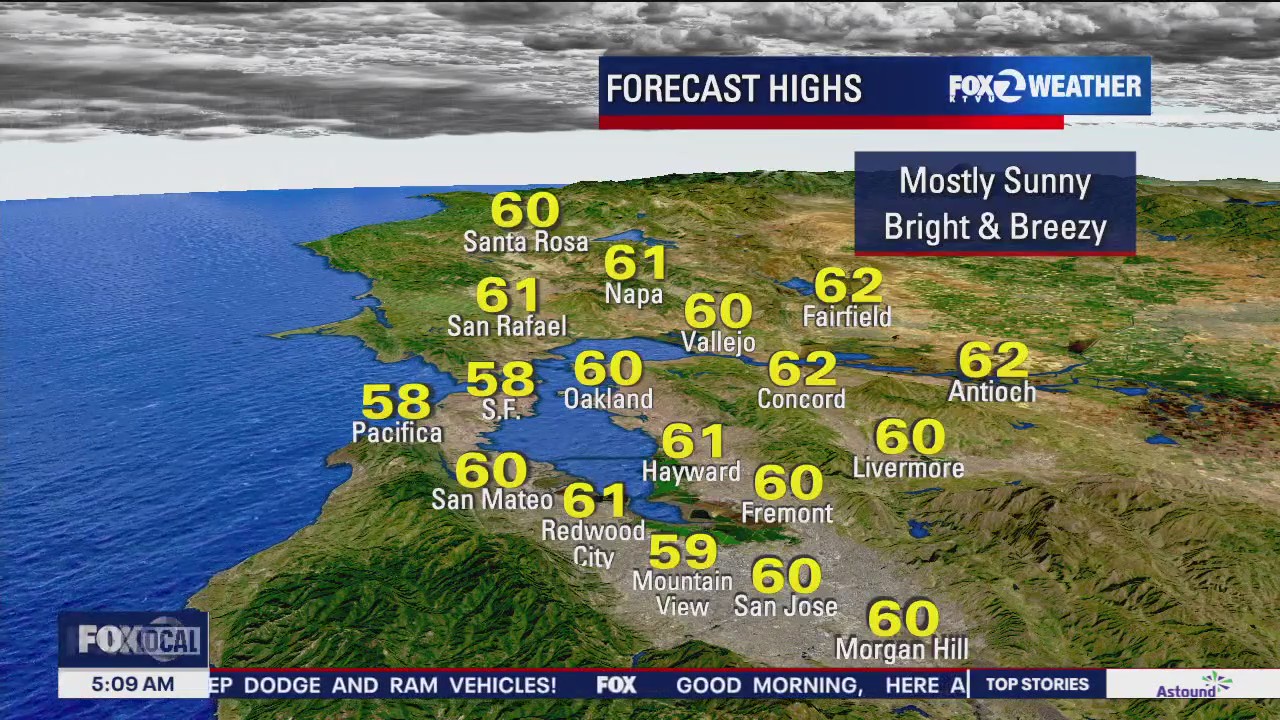
Partly sunny and mild today
Partly sunny and seasonal temps. today before a notable warm up arrives Sunday through Tuesday. Afternoon highs today will range from upper 50s at the coast to upper 60s inland. Enjoy ~ Rosemary
Partly sunny and seasonal temps. today before a notable warm up arrives Sunday through Tuesday. Afternoon highs today will range from upper 50s at the coast to upper 60s inland. Enjoy ~ Rosemary


Warming temperatures
TGIF! Your Saturday forecast features mostly cloudy skies and mild temperatures. A significant warming trend will begin Sunday. By Monday, the warmest parts of the Bay Area will approach the low 80s! Have a great weekend! -Mark
TGIF! Your Saturday forecast features mostly cloudy skies and mild temperatures. A significant warming trend will begin Sunday. By Monday, the warmest parts of the Bay Area will approach the low 80s! Have a great weekend! -Mark


Warmer weather on the way
Here's the latest forecast from the KTVU weather team.
Here's the latest forecast from the KTVU weather team.


Mixture of sun and clouds
The Bay Area gets a break from the rain! Partly sunny skies will highlight your Friday forecast. Temperatures will be warming over the weekend. By Monday, the warmest locations will be flirting with 80 degrees! Have a great Friday! -Mark
The Bay Area gets a break from the rain! Partly sunny skies will highlight your Friday forecast. Temperatures will be warming over the weekend. By Monday, the warmest locations will be flirting with 80 degrees! Have a great Friday! -Mark


Patchy fog, party sunny
Today will see patchy fog and partly sunny skies.
Today will see patchy fog and partly sunny skies.


Wednesday evening showers
A weak system will zip across the Bay Area Wednesday evening. The highest rainfall totals will be focused in the North Bay (up to .30"). Spring begins Thursday! Partly sunny skies are expected. The upcoming weekend should be nice! Temperatures will warm early next week.
A weak system will zip across the Bay Area Wednesday evening. The highest rainfall totals will be focused in the North Bay (up to .30"). Spring begins Thursday! Partly sunny skies are expected. The upcoming weekend should be nice! Temperatures will warm early next week.


Increasing clouds, evening rain
There will be increasing clouds today and a chance of evening rain.
There will be increasing clouds today and a chance of evening rain.


Another round of showers
After a nice break in the rain, the final system of winter will approach the Bay Area Wednesday afternoon. Mostly cloudy skies are expected tomorrow. Shower chances will be going up during the evening hours. The showers will be focused in the North Bay. Spring begins Thursday! Our next warming trend begins this weekend.
After a nice break in the rain, the final system of winter will approach the Bay Area Wednesday afternoon. Mostly cloudy skies are expected tomorrow. Shower chances will be going up during the evening hours. The showers will be focused in the North Bay. Spring begins Thursday! Our next warming trend begins this weekend.

Mostly sunny
Mostly sunny today, highs in the 60s.
Mostly sunny today, highs in the 60s.


Off-and-on rain
Off-and-on rain today. Highs in the 50s
Off-and-on rain today. Highs in the 50s


Wet and windy weather on the way
Mostly cloudy skies, cool temps. and winds ramping up ahead of rain later today. A Wind Advisory for the North Bay begins at 11am, a Wind Advisory for the Easy Bay, San Francisco Peninsula, Coast, and Santa Cruz Mountains. Rain moves into the North Bay late afternoon with scattered showers and rain developing over the Central and South Bay tonight. Chance of showers and slight risk of thunderstorms continue into Monday.
Mostly cloudy skies, cool temps. and winds ramping up ahead of rain later today. A Wind Advisory for the North Bay begins at 11am, a Wind Advisory for the Easy Bay, San Francisco Peninsula, Coast, and Santa Cruz Mountains. Rain moves into the North Bay late afternoon with scattered showers and rain developing over the Central and South Bay tonight. Chance of showers and slight risk of thunderstorms continue into Monday.
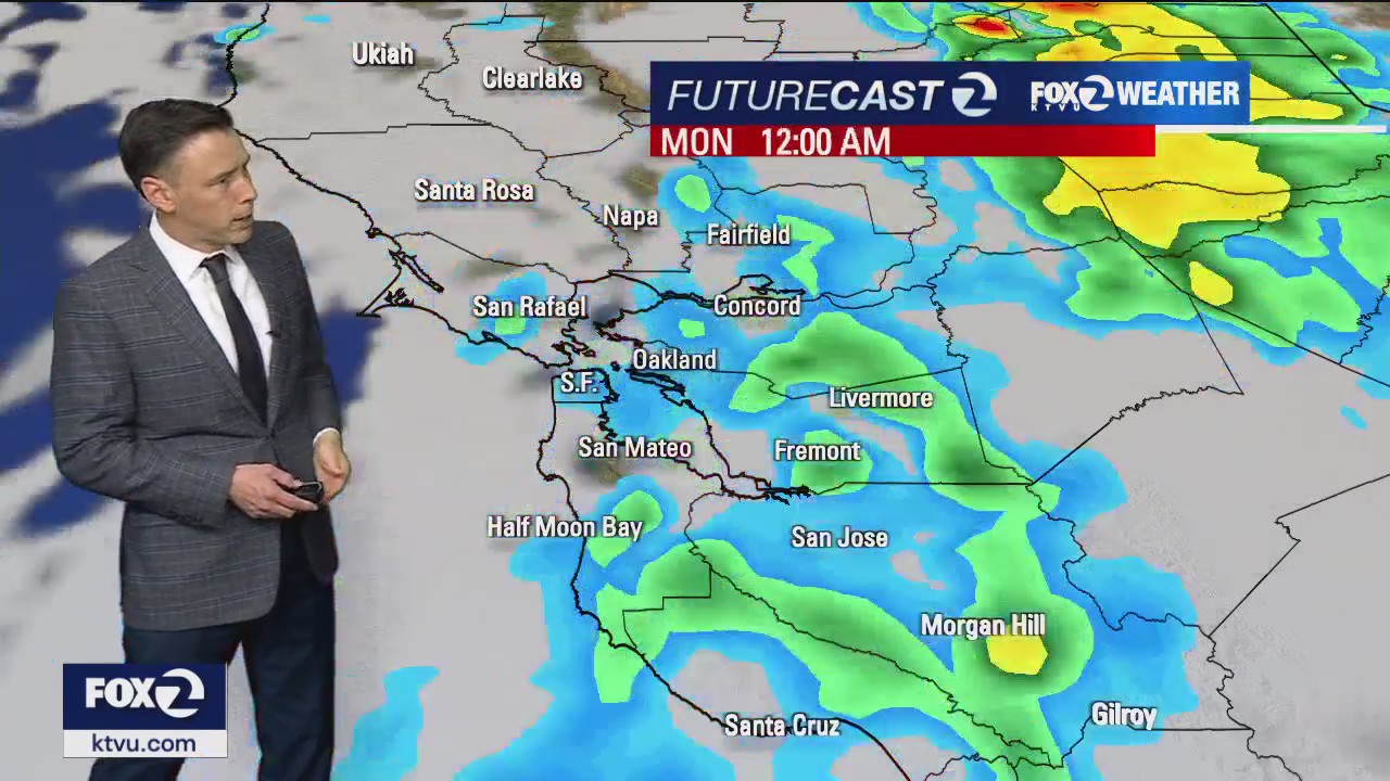

Another system on the way
The third storm in a week will be approaching the Bay Area during the second half of the weekend. Mostly cloudy skies are expected Sunday. A Wind Advisory (gusts to 45 mph) has been posted for the North Bay Hills. There is the chance of a few showers in the North Bay throughout the day. The main rain band, linked to the next storm, moves in Sunday evening. Showers, with the chance of thunderstorms, stick around in the Monday forecast. The Sierra will pick up more snow! Another Winter Storm Warning begins 5 pm Sunday.
The third storm in a week will be approaching the Bay Area during the second half of the weekend. Mostly cloudy skies are expected Sunday. A Wind Advisory (gusts to 45 mph) has been posted for the North Bay Hills. There is the chance of a few showers in the North Bay throughout the day. The main rain band, linked to the next storm, moves in Sunday evening. Showers, with the chance of thunderstorms, stick around in the Monday forecast. The Sierra will pick up more snow! Another Winter Storm Warning begins 5 pm Sunday.

A break in the rain today
Happy Saturday Everyone. Partly sunny skies and highs slightly below average today. Expect upper 50s to low 60s for the afternoon with generally light winds. The next storm arrives on Sunday.
Happy Saturday Everyone. Partly sunny skies and highs slightly below average today. Expect upper 50s to low 60s for the afternoon with generally light winds. The next storm arrives on Sunday.


Clouds and sun this weekend
The Bay Area gets a break from the downpours for most of the weekend. We are expecting partly to mostly cloudy skies in your Saturday forecast. There is the slight chance of showers in the North Bay. Our next system will be making its approach Sunday evening. Have a great weekend! -Mark
The Bay Area gets a break from the downpours for most of the weekend. We are expecting partly to mostly cloudy skies in your Saturday forecast. There is the slight chance of showers in the North Bay. Our next system will be making its approach Sunday evening. Have a great weekend! -Mark


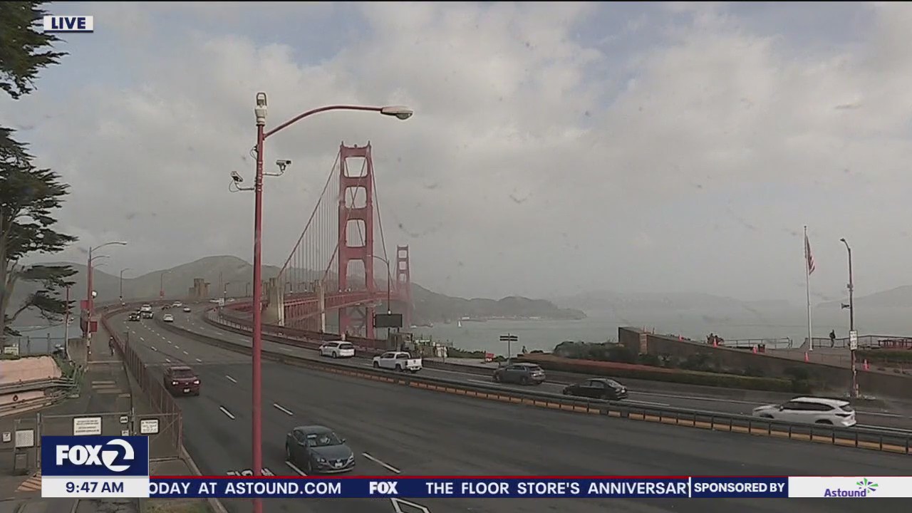
Bay Area rain makes for a wet morning commute
KTVU meteorologist Steve Paulson is tracking rain showers all around the Bay Area.
KTVU meteorologist Steve Paulson is tracking rain showers all around the Bay Area.


More rain on the way
System #2 will move into the Bay Area early Friday morning. Winds will be picking up too. Gusts could approach 40 mph. Saturday will be dry! Another system could boost rain chances Sunday evening. In the Sierra, a Winter Storm Warning is place until 11 pm Friday.
System #2 will move into the Bay Area early Friday morning. Winds will be picking up too. Gusts could approach 40 mph. Saturday will be dry! Another system could boost rain chances Sunday evening. In the Sierra, a Winter Storm Warning is place until 11 pm Friday.
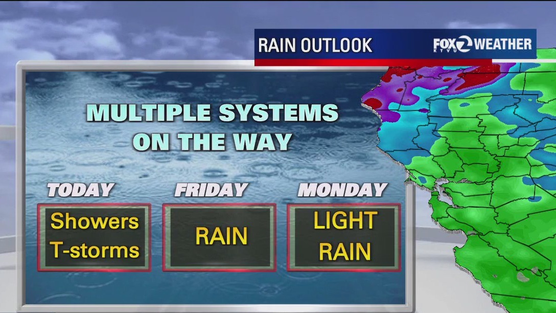

Possible thunderstorms in the forecast
KTVU meteorologist Steve Paulson said there will be some sunshine with a chance of thunderstorms and hail.
KTVU meteorologist Steve Paulson said there will be some sunshine with a chance of thunderstorms and hail.