


Possible thunderstorms in the forecast
KTVU meteorologist Steve Paulson said there will be some sunshine with a chance of thunderstorms and hail.
KTVU meteorologist Steve Paulson said there will be some sunshine with a chance of thunderstorms and hail.


Active weather stretch continues
System 1 moved into the Bay Area Wednesday afternoon. The heavy rain and strong winds area moving out.. Scattered showers, along with the chance of thunderstorms, will remain in the Thursday forecast. Snow levels will collapse to roughly 3000 feet. System #2 will approach the area Friday morning. A third system could boost shower chances Sunday afternoon - evening.
System 1 moved into the Bay Area Wednesday afternoon. The heavy rain and strong winds area moving out.. Scattered showers, along with the chance of thunderstorms, will remain in the Thursday forecast. Snow levels will collapse to roughly 3000 feet. System #2 will approach the area Friday morning. A third system could boost shower chances Sunday afternoon - evening.


Severe thunderstorm warning for some parts of Bay Area
Several part of the Bay Area were under a severe thunderstorm warning on Wednesday afternoon.
Several part of the Bay Area were under a severe thunderstorm warning on Wednesday afternoon.


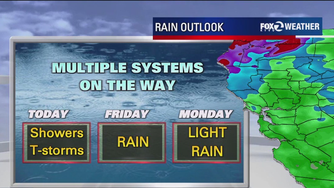
Multiple storms on the way
Storm #1 will move into the Bay Area Wednesday. Moderate to heavy rain will cover most of the Bay Area. Thunderstorm chances have also been added to the forecast. Wind gusts could approach 45 mph as the main front approaches. The Sierra will pick up a lot of snow! A Winter Storm Warning has been issued. The snow outlook calls for 1 -4 feet of snow.
Storm #1 will move into the Bay Area Wednesday. Moderate to heavy rain will cover most of the Bay Area. Thunderstorm chances have also been added to the forecast. Wind gusts could approach 45 mph as the main front approaches. The Sierra will pick up a lot of snow! A Winter Storm Warning has been issued. The snow outlook calls for 1 -4 feet of snow.


A major shift in the weather on the way
Minor changes today before our spring like weather fades and winter returns. A cold storm arriving tomorrow will bring bay area rain, wind, and the risk of thunderstorms. A dusting of snow in our higher hills with several feet of snow in the Sierra also expected.
Minor changes today before our spring like weather fades and winter returns. A cold storm arriving tomorrow will bring bay area rain, wind, and the risk of thunderstorms. A dusting of snow in our higher hills with several feet of snow in the Sierra also expected.


Bay Area storm could bring snow to high hills
A storm rolling in from the Gulf of Alaska will bring rain to the Bay and maybe even some snow to portions of California.
A storm rolling in from the Gulf of Alaska will bring rain to the Bay and maybe even some snow to portions of California.


Minor changes today, wet weather on the way
Cold mornings and mild afternoons will remain for today and Tuesday before Bay Area rain, wind and Sierra snow arrives mid week.
Cold mornings and mild afternoons will remain for today and Tuesday before Bay Area rain, wind and Sierra snow arrives mid week.


Mid-week rain coming to the Bay Area
Cool and cloudy weather will give way to windy and rainy conditions as the week progresses.
Cool and cloudy weather will give way to windy and rainy conditions as the week progresses.


A chilly weekend before more rain arrives
Following a chilly start to the morning, another pleasant afternoon is expected with highs ranging from upper 50s at the coasts to upper 60s inland. Subtle changes expected Monday and Tuesday before wet weather returns on Wednesday.
Following a chilly start to the morning, another pleasant afternoon is expected with highs ranging from upper 50s at the coasts to upper 60s inland. Subtle changes expected Monday and Tuesday before wet weather returns on Wednesday.


The chill in the air remains
The weekend continues with clear skies but a cold chill sticks around a little longer.
The weekend continues with clear skies but a cold chill sticks around a little longer.


Another nice forecast
The mild pattern will remain in place through the weekend. Patchy fog could resurface Sunday morning. Partly sunny skies are expected during the afternoon. Most neighborhoods should warm into the 60s. The pattern will be changing next week. Significant rain is expected to return. Wednesday is the day to watch. Enjoy the rest of your weekend! -Mark
The mild pattern will remain in place through the weekend. Patchy fog could resurface Sunday morning. Partly sunny skies are expected during the afternoon. Most neighborhoods should warm into the 60s. The pattern will be changing next week. Significant rain is expected to return. Wednesday is the day to watch. Enjoy the rest of your weekend! -Mark


Mostly sunny and 60s for the afternoon
Following a chilly start and patchy fog on the coast, temps. will soar to above average for the afternoon. We can expect low 60s at the coast to upper 60s inland. Enjoy ~Rosemary
Following a chilly start and patchy fog on the coast, temps. will soar to above average for the afternoon. We can expect low 60s at the coast to upper 60s inland. Enjoy ~Rosemary


Nice weekend forecast
The mild stretch will remain in place this weekend. The warmest parts of the Bay Area could be flirting with 70 degrees! The pattern will be shifting next week. The chance of rain has been added to the Tuesday forecast. A stronger system could boost rainfall rates by Wednesday. Stronger winds may also move into the area. Have a great weekend! -Mark
The mild stretch will remain in place this weekend. The warmest parts of the Bay Area could be flirting with 70 degrees! The pattern will be shifting next week. The chance of rain has been added to the Tuesday forecast. A stronger system could boost rainfall rates by Wednesday. Stronger winds may also move into the area. Have a great weekend! -Mark


Lots of sun
Lots of sun. Temps in the mid-60s.
Lots of sun. Temps in the mid-60s.


Shower threat moving out
The showers will continue to move out of the Bay Area. As the showers move out, cold air moves in. A Frost Advisory has been issued Friday morning for the North Bay and the East Bay Hills. Sunny skies and mild temperatures will highlight the Friday afternoon forecast. The weekend will be dry. Significant rain could resurface in the forecast next week.
The showers will continue to move out of the Bay Area. As the showers move out, cold air moves in. A Frost Advisory has been issued Friday morning for the North Bay and the East Bay Hills. Sunny skies and mild temperatures will highlight the Friday afternoon forecast. The weekend will be dry. Significant rain could resurface in the forecast next week.


Rain in forecast
There is rain in the forecast.
There is rain in the forecast.


Chance of Thursday showers
Our unsettled pattern continues. Showers are expected to move through parts of the Bay Area Thursday. Shower chances will be highest in the morning. We are expected dry and warmer conditions this weekend. We "spring forward" Sunday morning!
Our unsettled pattern continues. Showers are expected to move through parts of the Bay Area Thursday. Shower chances will be highest in the morning. We are expected dry and warmer conditions this weekend. We "spring forward" Sunday morning!


Severe thunderstorm warning issued for parts of Santa Clara County
A severe thunderstorm warning was issued for several cities in Santa Clara County by the National Weather Service on Wednesday.
A severe thunderstorm warning was issued for several cities in Santa Clara County by the National Weather Service on Wednesday.


Rain on the way, favoring the South Bay.
Active weather continues Wednesday with rain expected on the morning commute. Steady light rain will favor the South Bay with a chance of showers for the rest. Snow in the Sierra with a Winter Weather Advisory beginning at 4 AM for travel over the West Slope and Greater Lake Tahoe Area.
Active weather continues Wednesday with rain expected on the morning commute. Steady light rain will favor the South Bay with a chance of showers for the rest. Snow in the Sierra with a Winter Weather Advisory beginning at 4 AM for travel over the West Slope and Greater Lake Tahoe Area.


Chance of Wednesday showers
Our next system will approach the Bay Area coast and split. Wednesday rainfall amounts, as result, will be on the lower side. Highest shower chances will be focused in the South Bay. The bulk of the rain should fall during the morning hours. We are tracking another chance of rain in the Thursday forecast. Your weekend looks dry. Significant rain may return to the area next week.
Our next system will approach the Bay Area coast and split. Wednesday rainfall amounts, as result, will be on the lower side. Highest shower chances will be focused in the South Bay. The bulk of the rain should fall during the morning hours. We are tracking another chance of rain in the Thursday forecast. Your weekend looks dry. Significant rain may return to the area next week.