


Light rain, cooler
Today could see light rain with cooler temps.
Today could see light rain with cooler temps.


Sunny, fair
Today will be sunny and fair with highs in the 60s.
Today will be sunny and fair with highs in the 60s.


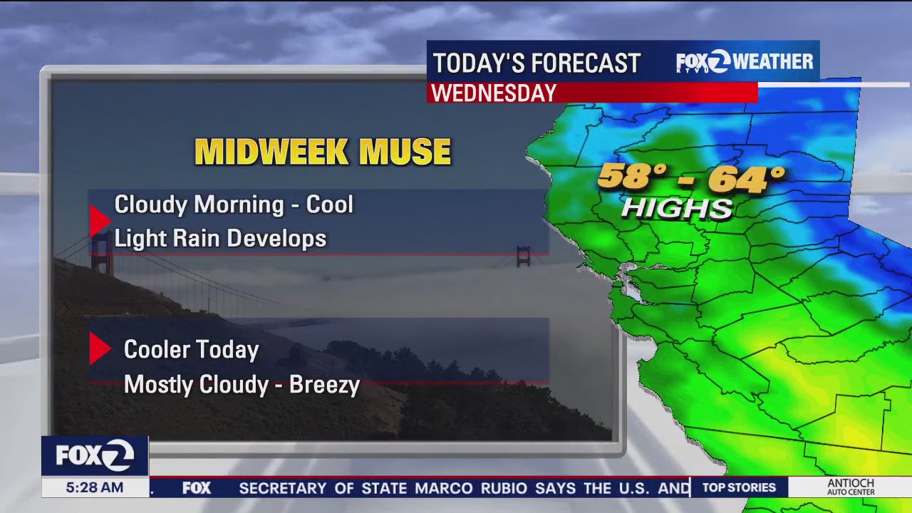
Morning showers followed by a cloudy, dry afternoon
Sprinkles over the Bay Area through the morning followed by cloudy mainly dry weather for the rest of the day. Afternoon highs will range from upper 50s to low 60s.
Sprinkles over the Bay Area through the morning followed by cloudy mainly dry weather for the rest of the day. Afternoon highs will range from upper 50s to low 60s.


Chance of Sunday showers
A weak system will move into the Bay Area Sunday. We could be tracking scattered showers during the first half of the day.
A weak system will move into the Bay Area Sunday. We could be tracking scattered showers during the first half of the day.


Mostly cloudy, dry, cool today
Following a frosty start to the day, afternoon highs will range from the upper 50s to low 60s under partly sunny skies. Light showers return Sunday morning. Happy Saturday ~Rosemary
Following a frosty start to the day, afternoon highs will range from the upper 50s to low 60s under partly sunny skies. Light showers return Sunday morning. Happy Saturday ~Rosemary


Weekend clouds
The storm clouds have moved out of town. Saturday should be dry! Patchy frost returns early in the morning. Mostly cloudy skies are expected for most of the day A weak system will approach the area late Saturday. The chance of showers has been added to the Sunday morning forecast. Have a great weekend! -Mark
The storm clouds have moved out of town. Saturday should be dry! Patchy frost returns early in the morning. Mostly cloudy skies are expected for most of the day A weak system will approach the area late Saturday. The chance of showers has been added to the Sunday morning forecast. Have a great weekend! -Mark


Lingering rain, windy
Today will see lingering rain and wind.
Today will see lingering rain and wind.


Storm is on the move
Rain will continue to move through the Bay Area Thursday evening. The showers are expected to taper overnight. Partly sunny skies return Friday. A few showers could stick around during the morning hours.
Rain will continue to move through the Bay Area Thursday evening. The showers are expected to taper overnight. Partly sunny skies return Friday. A few showers could stick around during the morning hours.


Rain off-and-on
Rain will continue off-and-on all day
Rain will continue off-and-on all day


Incoming storm
The forecast remains on track. Our next storm will track toward the Bay Area Wednesday night. Heavy rain and strong winds will move in early Thursday morning. A Flood Watch and High Wind Warning have been posted. Thunderstorm chances have also been added to the forecast.
The forecast remains on track. Our next storm will track toward the Bay Area Wednesday night. Heavy rain and strong winds will move in early Thursday morning. A Flood Watch and High Wind Warning have been posted. Thunderstorm chances have also been added to the forecast.


Rain, cold
The rain is coming tonight and lasting through Thursday.
The rain is coming tonight and lasting through Thursday.


Next storm arrives Wednesday night
We are on storm watch. Clouds will continue to move into the Bay Area Wednesday, While shower chances have been added to the forecast, the real rain will be moving in Wednesday night. The winds will also be factor. Gusts could exceed 50 mph across parts of the Bay Area. The Thursday morning commute will be extra challenging with heavy rain and strong winds.
We are on storm watch. Clouds will continue to move into the Bay Area Wednesday, While shower chances have been added to the forecast, the real rain will be moving in Wednesday night. The winds will also be factor. Gusts could exceed 50 mph across parts of the Bay Area. The Thursday morning commute will be extra challenging with heavy rain and strong winds.


Clear, cold cycle continues
Following a freezing and sub freezing start to the day, afternoon highs will range in the mid 50s to low 60s. Increasing clouds tomorrow ahead of wet weather returning Tuesday night into Wednesday.
Following a freezing and sub freezing start to the day, afternoon highs will range in the mid 50s to low 60s. Increasing clouds tomorrow ahead of wet weather returning Tuesday night into Wednesday.


Cold temps
Today is going to be cold. Temps in the 50s
Today is going to be cold. Temps in the 50s


Clear and cold continues
Frosty mornings and relatively cool afternoons will continue today through Tuesday. An increase in clouds will roll in on Tuesday ahead of a transition to wet, breezy weather by mid week. Frost Advisory and Freeze Warning slated for Monday morning between 1AM - 9AM
Frosty mornings and relatively cool afternoons will continue today through Tuesday. An increase in clouds will roll in on Tuesday ahead of a transition to wet, breezy weather by mid week. Frost Advisory and Freeze Warning slated for Monday morning between 1AM - 9AM


Sunny Super Bowl Sunday
Bundle up Sunday morning. Most of the Bay Area will start off the day in the chilly 30s. Mostly sunny skies will highlight the afternoon forecast. Our break in the rain continues into early next week. We are tracking rain chances as early as Wednesday. Have a great Super Bowl Sunday! -Mark
Bundle up Sunday morning. Most of the Bay Area will start off the day in the chilly 30s. Mostly sunny skies will highlight the afternoon forecast. Our break in the rain continues into early next week. We are tracking rain chances as early as Wednesday. Have a great Super Bowl Sunday! -Mark


Clear and cold
Our attention remains on cold mornings. Most inland areas will be in the low to mid 30s with upper 30s to low 40s closer to the coast. Afternoon highs will warm into the upper 50s, under partly cloudy, dry weather. Next chance for rain and wind arrives on Wednesday.
Our attention remains on cold mornings. Most inland areas will be in the low to mid 30s with upper 30s to low 40s closer to the coast. Afternoon highs will warm into the upper 50s, under partly cloudy, dry weather. Next chance for rain and wind arrives on Wednesday.


Dry weather returns this weekend
The storm clouds will move out of the Bay Area this weekend. The cold air will move in! Freeze Warnings and Frost Advisories have been issued for Saturday morning. Mostly sunny skies will highlight the afternoon forecast. No big changes in your Sunday forecast. Have a great weekend! -Mark
The storm clouds will move out of the Bay Area this weekend. The cold air will move in! Freeze Warnings and Frost Advisories have been issued for Saturday morning. Mostly sunny skies will highlight the afternoon forecast. No big changes in your Sunday forecast. Have a great weekend! -Mark


Scattered showers, cloudy, cool
Today will see scattered showers, clouds and cool temps. Highs in the 50s
Today will see scattered showers, clouds and cool temps. Highs in the 50s


Scattered showers
Thursday's storm will be moving out of the area tomorrow. Shower chances will remain in the Friday forecast. As cold air moves in, snow levels will drop to 3000 feet. Shower chances will be diminishing later in the day. Dry weather returns this weekend.
Thursday's storm will be moving out of the area tomorrow. Shower chances will remain in the Friday forecast. As cold air moves in, snow levels will drop to 3000 feet. Shower chances will be diminishing later in the day. Dry weather returns this weekend.