

California wildfires devour the equivalent of Delaware; vary in size and devastation
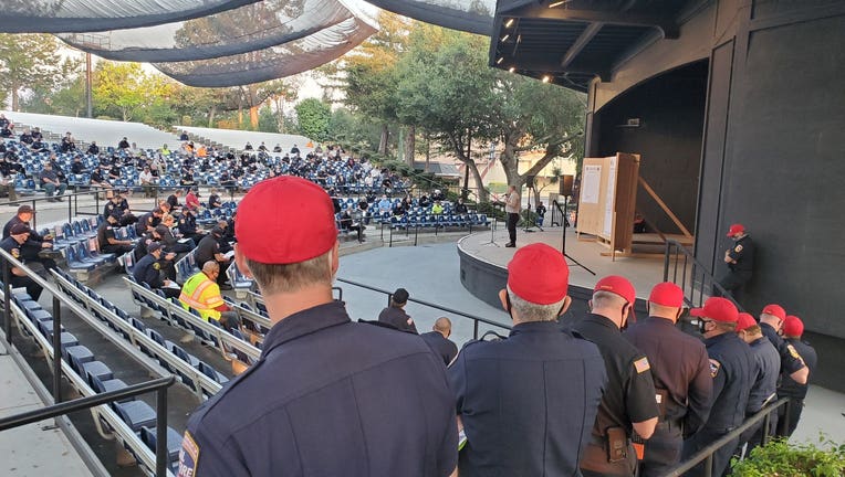
Cal Fire briefing. Aug. 26, 2020
OAKLAND, Calif. - Cal Fire crews said early Wednesday that they're still going strong, 11 days into a statewide firefight of 700 blazes, which have burned more than 1 million acres, or about 1% of the Golden State's overall landmass.
That's roughly the size of the state of Delaware.
The 15,000 firefighters on the front lines have repeatedly told the public that they are short on resources and weary from working three-day shifts in a row.
At a news conference on Wednesday, Gov. Gavin Newsom called Cal Fire and their mutual aid partners from out-of-state "heroes" and "best in class."
Interactive map: See where wildfires are burning across the Bay Area
CZU, LNU, SCU? How does Cal Fire name wildfires?
Veteran firefighter loses everything in CZU Complex Fire while protecting homes from another blaze
The massive fires also came much earlier in the season than expected and complications from the coronavirus pandemic and a lack of inmate crews have pushed crews to their extreme limits.
“Between the fires in Southern California and these, they’ve been going nonstop,” said Tim Edwards, president of the union representing state firefighters. “Fatigue is really starting to set in, but they’re doing it.”
Yet still, more than a week after lightning strikes sparked wildfires across the state, their efforts were paying off, and the nature of the fires varied in size, destruction and death tolls.
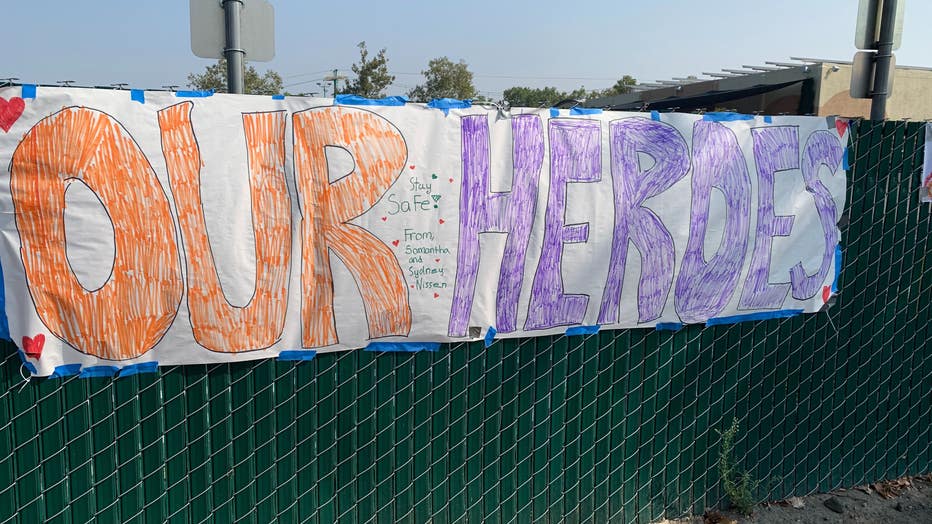
Residents leave thank you posters for firefighters at the Alameda County fairgrounds. Aug. 25, 2020
In terms of the SCU Lightning Complex Fire, California's largest wildfire spanning seven counties including three in the Bay Area, crews had contained 25% of the blaze by Wednesday. The fires had burned nearly 366,000 acres.
Despite the massive nature of the fire, no one had died and just 27 structures had either been damaged or destroyed.
To compare, the CZU August Lightning Complex Fire burning in Santa Cruz and San Mateo counties, had burned far less land: 80,000 acres.
But it has been far more destructive in terms of ripping through homes and buildings, destroying more than 530 structures.
And in terms of human life, the LNU Lightning Complex, burning about 357,000 acres mostly in the North Bay, had killed the most people. The death toll on Wednesday stood at five. And it had destroyed or damaged the most buildings: At least 1,200.
Combined, the state's blazes have killed at least seven people, burned some 1,700 homes and other buildings, and prompted evacuation orders that still affect about 140,000 people.
The Associated Press contributed to this report.
SCU LIGHTNING COMPLEX EVACUATION ORDER REDUCED TO WARNING AND WARNING LIFTED
WHAT: EVACUATION ORDER REDUCED TO WARNING
WHEN: Effective Immediately
WHERE:
SAN JOAQUIN COUNTY – ZONE 10B: South of West Corral Hollow Road to the fire perimeter, to the Alameda County Line and Stanislaus County Line West of I-580 to Alameda county line outside the fire perimeter East of the Alameda county line to I-580 and the Stanislaus county line outside the fire perimeter North of the San Joaquin/Stanislaus County Line to Corral Hollow Rd, outside the fire perimeter
WHAT: EVACUATION ORDER WARNING LIFTED
WHEN: Effective Immediately
WHERE:
SAN JOAQUIN COUNTY – ZONE 11:All of PAR Estates which are the following streets: W. Vernalis Road, Bernard Drive, Stearman Road, Brichetto Court, Stearman Court, S. Chrisman Road south of I-580, and the Tracy Golf & Country Club
WHAT: EVACUATION ORDER WARNING LIFTED
WHEN: Effective Immediately
WHERE:
SAN JOAQUIN COUNTY – ZONE 13: North of West Corral Hollow Road to I-580 East of the Alameda county line to I-580
SCU LIGHTNING COMPLEX FIRE EVACUATION WARNING LIFTED
WHAT: EVACUATION WARNING LIFTED
WHEN: Effective Immediately
WHERE:
SANTA CLARA COUNTY – ZONE 16: South of Eagle View Dr., East of Peet Rd., North of Half Rd., West of Cochrane Rd., West of Coyote Creek
NOTES: Please go to: www.tinyurl.com/scu-evacmap for an online evacuation map.
WHAT: Fire and Law Enforcement officials will provide an update on fire conditions and will be available to answer questions after the press conference.
WHEN: August 25, 2020 3:00 PM – Press Conferences will be held at 3PM daily until further notice.
WHERE:
Alameda County Fair Grounds – Located in Farmhouse Building
4501 Pleasanton Ave
Pleasanton, CA 94566
NOTES: Press Conference will be lived streamed via Twitter @CALFIRESCU. Please ensure the use of a facial covering for media members attending. All County COVID-19 guidelines will be adhered to.
The SCU Lightning Complex started on August 16th with multiple fires within the complex. These fires have since merged into one major fire which is broken into three zones; Canyon, Calaveras, and Deer. The Deer Zone is currently 100% contained.
Fire activity has lessened due to favorable weather conditions and increased humidity across the complex. Deep seated heat still remains in the bottom of the steep, inaccessible drainages. During the evening fire crews held existing control line around the fire perimeter continuing to both reinforce and add new containment lines. When weather and conditions are favorable there will be a controlled burn operation inside the control line. This controlled burn will widen the buffer and consume fuel between the edge of the fire and the control line. If residents see large columns of smoke it most likely will be from the controlled burn. Fire crews and aircraft will continue to mitigate hazards and spots today. We remind the public that if they are repopulated that fire crews may still be working in the area and to be cautious while driving.
Deer Zone: [Contra Costa County]
Calaveras Zone: [Alameda County / Santa Clara County / Stanislaus County]
Canyon Zone: [Stanislaus County / San Joaquin County/Merced County]
Evacuations Orders: Santa Clara County:
(8/25/20 7:00 AM)
Zone 2A
East of the fire perimeter to Mines Rd. and San Antonio Rd.
West of Mines Rd. and San Antonio Rd. to the fire perimeter
South of the Alameda/ Santa Clara County Line to Hwy 130
North of Hwy 130 to the Alameda/ Santa Clara County Line
Zone 3A
East of San Felipe Rd. to the Santa Clara/Stanislaus County Line
South of Mt. Hamilton/Hwy 130
West of Santa Clara/Stanislaus County Line to San Felipe Rd.
Zone 5
East of Shingle Valley Rd. and everything East of Anderson Lake, East of Coyote Creek,
East of Coyote Reservoir, East of Roop Rd. East of Leavesley Rd., East of Crews Rd.,
East of Ferguson Rd.
East and North of Hwy 152
West of the Merced County Line, North of Hwy 152
South of Metcalf Rd. at Shingle Valley Rd., East to the Stanislaus County Line
Zone 9
South of the Alameda/Santa Clara County Line in between Mines Rd. and the Stanislaus/San Joaquin County line to Del Puerto Canyon Rd.
East of Mines Rd to Santa Clara/Stanislaus County Line
North of Del Puerto Canyon Rd. to Alameda/Santa Clara County Line in between Mines Rd. and the Stanislaus/San Joaquin County
West of Santa Clara/Stanislaus County Line to Mines Rd. in between the Alameda/Santa Clara County Line and Del Puerto Canyon Rd.
Stanislaus County:
Zone 7A:
Everything within the fire perimeter
South of Orestimba Rd. and Orestimba Creek to the Stanislaus/Merced County Line
West of the fire perimeter to the I-5
North of the Stanislaus/Merced County Line to Orestimba Rd. and Orestimba Creek
East of the I-5 in between Orestimba Rd. and the Stanislaus/Merced County Line to the fire perimeter
Alameda County:
Zone 12:
All of Mines Road, south of Mile Marker 10 to the county line
Zone 15F:
South of fire perimeter to the Alameda/Santa Clara County Line
San Joaquin County:
Zone 10A:
South of the fire perimeter to the Alameda & Stanislaus County Line
Evacuation Warnings:
San Joaquin County:
Zone 10B:
South of West Corral Hollow Road to the fire perimeter, to the Alameda County Line and Stanislaus County Line
West of I-580 to Alameda county line outside the fire perimeter
East of the Alameda county line to I-580 and the Stanislaus county line outside the fire
perimeter North of the San Joaquin/Stanislaus County Line to Corral Hollow Rd, outside the fire perimeter
Stanislaus County:
Zone 7B:
Everything within the fire perimeter South of Orestimba Rd. and Orestimba Creek to the Stanislaus/Merced County Line
West of the fire perimeter to the I-5
North of the Stanislaus/Merced County Line to Orestimba Rd. and Orestimba Creek
East of the I-5 in between Orestimba Rd. and the Stanislaus/Merced County Line to the fire perimeter
Stanislaus County:
Zone 8:
All areas of Diablo Grande Pkwy and the Diablo Grande Community have been lifted to an evacuation warning to residents only.
Alameda County:
Zone 15A:
South of Tesla Rd., South of the Livermore City limits (excluding the cities of Livermore and Pleasanton), South of Hwy 84 in between Vineyard Ave. and I-680, South of I-680 to the fire perimeter and the Alameda/Santa Clara County Line.
West of the Alameda/San Joaquin County Line to the Livermore city limits, to Calaveras Rd
North of fire perimeter and the Alameda/Santa Clara County Line to Hwy 84, to the Livermore city limits
Zone 15B:
South of Welch Creek Rd. to the fire perimeter and the Alameda/Santa Clara County Line
East of Calaveras Rd. at Welch Creek Rd. to the fire perimeter
Zone 19:
Inside of the Ohlone Fire Perimeter
Santa Clara County:
Zone 2B:
East of Sierra Rd. and Felter Rd., East of Milpitas and San Jose City Limits to the fire perimeter
North of Mt. Hamilton Rd. to the Alameda/Santa Clara County Line
*Marsh Rd. remains closed at the fire perimeter located at Arroyo Hondo Bridge
Santa Clara County:
Zone 3B:
West of San Felipe Rd. to the San Jose City Limits
North of Metcalf Rd. to the San Jose City Limits
East of San Jose City Limits to San Felipe Rd.
South of San Jose City Limits to Metcalf Rd.
Santa Clara County:
Zone 3C:
Quimby Rd.north to Hwy 130
East of San Jose city limits to Mt. Hamilton Rd
South of Mt. Hamilton Rd. to Quimby Rd.
Hamilton Rd. west to the San Jose City Limits
Zone 4A:
North of Magnolia Ct. and Magnolia Way,
East of Lower Thomas Grade along the East Dunne Corridor
East of Hwy 101 to Meltcalf Rd., East of Coyote Creek, East of Cochrane Rd.,
East of Hill Rd., South of Main Ave. North of Dunne Ave., West of Shingle Valley Rd. and Anderson Lake, to include the Jackson Oaks and Holiday Lake Estates.
South of Metcalf Rd.
Zone 4B:
South of Dunne Ave. and West of Lower Thomas Grade, East of Hill Rd.,
North of Maple Ave., Foothill Ave., North San Martin Ave., East of New Ave. North of Roop Rd.,
West of Coyote Creek and Coyote Lake
Zone 6:
East of Lovers Lane and the Santa County Line
South of Hwy 152 to the San Benito County Line West to the Merced County Line
North of the San Benito County Line to Hwy 152
Merced County:
Zone 14:
North of Hwy 152 to I-5 to the Santa Clara County Line and Stanislaus County Line
West of the I-5 EXCLUDING THE COMMUNITY OF SANTA NELLA East of Santa Clara County Line and Stanislaus County Line to the Delta-Mendota
South of the Stanislaus County Line to Hwy 152
Temporary Evacuation Points:
Creekside Middle School:535 Peregrine Dr, Patterson, CA 95363
Milpitas Library: 160 N Main St Milpitas, CA 95035
Ann Sobrato High School – Performing Arts Building: 401 Burnett Ave. Morgan Hill, CA 95037
Road Closures:
Holiday Dr. at East Dunne Ave., Coyote Reservoir Rd. at Roop Rd., Canada Rd. at Hwy 152, Hwy 152 at Belle Station
Del Puerto Canyon Road (SR-130) between Mines Road and Diablo Grande PKWY
Hwy 130 at Three Springs Rd.
Hwy 130 at Quimby Rd.