

CZU August Lightning Complex Fire nearly doubles in San Mateo and Santa Cruz counties
SANTA CRUZ, Calif. - The wildfires raging in San Mateo and Santa Cruz counties grew by 15,000 acres overnight, scorching a total of 40,000 acres by Thursday morning.
At an early morning news conference, Santa Cruz County Sheriff's Chief Deputy Chris Clark implored people to heed evacuation warnings and orders, adding that there "are people unaccounted for."
Thousands evacuated in CZU August Lightning Complex Fire in San Mateo and Santa Cruz counties
Roughly 48,000 residents have already been told to leave their homes because of the CZU August Lightning Complex Fire, named after the Cal Fire San Mateo-Santa Cruz unit fighting the blaze.
So far, at least 50 structures have been destroyed, Cal Fire officials said.
The areas affected by evacuation warnings grew Thursday. The campus of UC-Santa Cruz and downtown Scotts Valley were included in a warning issued by Cal Fire in the afternoon. (See the full list of orders and warnings below.)

Tourists and other "out-of-towners" staying in hotels and other rental properties were urged to leave Santa Cruz County on Thursday by county authorities worried about providing emergency services.
Residents with extra bedrooms, in-law units and "even tents" were asked to share their excess space with people fleeing from the sprawling fires.
"Local shelters are near capacity," the county said in a press release."The scale of existing and anticipated evacuation orders is unprecedented and the need to safely house evacuees is critica."
As of Wednesday night, the winds were moving south driving flames closer to towns like Bonny Doon and Boulder Creek in Santa Cruz County. In San Mateo County, the fire is threatening the communities of La Honda and Pescadero.
“Over there, I think we are watching the place that my family has loved and helped to take care of our whole life,” said Janelle Bartlett of Pescadero.
As wildfire smoke looms overhead, Janelle Barlett packed up, fearing her family’s business Venture Retreat Center in Pescadero in San Mateo County may no longer be standing.
“The building itself is over 100 years old,” said Barlett. “I believe all of its history is being burned right now and I just can't believe it.”
The fire is divided into the northern zone threatening the communities of La Honda and Pescadero in San Mateo County.

BONNY DOON - AUGUST 19: Samantha Amos kisses her donkey named Monarch as she tries to evacuate from her home in Bonny Doon, Calif., on Wednesday, Aug. 19, 2020. (Photo by Randy Vazquez/MediaNews Group/The Mercury News via Getty Images)
The southern zone is in Santa Cruz County. The fire is west of Empire Hills Road, impacting the town of Bonny Doon and moving toward Boulder Creek, Ben Lomand and Felton.
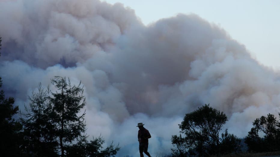
There was an early morning window for an air attack in Bonny Doon but the smoke was so heavy, aircraft was then grounded Wednesday.
Other challenges include where the fire is burning is heavily forested with redwoods and it’s remote.
“We use the term inaccessible a little bit too often as firefighters but this is the real deal when it comes to inaccessible,” said Dep. Chief Jonathan Cox of Cal Fire’s San Mateo-Santa Cruz unit.
Firefighters are working 48-hour shifts and they can’t be released with resources limited. They also can’t get assistance from any other part of the state. By Thursday evening, nearly 1,000 firefighters were battling the wildfires on the frontlines.
“You are standing in your home you've been in for many years and you don’t know what to take,” said Eilis Burke of Loma Mar.
Burke is hopeful she has a home to return to after her family evacuated in Loma Mar. She’s learned from past wildfires in other jurisdictions to heed orders.
“We just never had anything like this here. It’s been happening in California for quite some time,” said Burke. “We are all safe and our animals are safe that’s as good as it can get right now.”
Three firefighters had minor injuries battling the CZU fire.
As of Wednesday night, new evacuation orders are in place for areas of Alba Road, Hubbard Gulch, Fanny Grade, and Davenport South in Santa Cruz County. Parts of Pescadero and La Honda in San Mateo County are also under new orders.
Evacuations centers are set up at the Santa Cruz County Fairgrounds and Santa Cruz Civic Auditorium as well as Half Moon Bay High School.
SAN MATEO COUNTY, CALIFORNIA - AUGUST 18: A looker-on watches as a fire burns near Pescadero in San Mateo County, Calif., on Tuesday, August 18, 2020. (Photo by Nhat V. Meyer/MediaNews Group/The Mercury News via Getty Images)
EVACUATION ORDERS FOR SAN MATEO COUNTY:
Communities of Loma Mar and Dearborn Park Area (Zone SMC E018)
Pescadero Creek County Park Area (Zone SMC E024)
Butano Community Area (Zone SMC E098)
Butano State Park Area including Barranca Knolls Community (Zone SMC E019)
Butano Creek Drainage (Zone SMC E055)
South Skyline Blvd. Area near Highway 9 (SMC E049)
Russian Ridge Open Space Reserve Area (Zone SMC E027)
Middleton Tract Area (Zone SMC E044)
Portola Redwoods State Park and the Portola Heights Community Area (Zone SMC E048)
EVACUATION WARNINGS FOR SAN MATEO COUNTY:
Pescadero Beach Area (Zone SMC E075)
Pescadero Creek County Park area (Zone SMC E075)
Bean Hollow Area (Zone SMC E042)
Pescadero Area (Zone SMC E043)
San Gregorio Area (Zone SMC E022)
La Honda Area (Zone SMC E028)
Red Barn Area (Zone SMC E010)
Russian Bridge Open Space Area (Zone SMC E027)
Skylonda Area (Zone SMC E012)
Langley Hill Area ( Zone SMC E010)
EVACUATION ORDERS FOR SANTA CRUZ COUNTY:
Paradise Park (Zones: CRZ 63, CRZ 64)
University of Santa Cruz, campus only (Zone SCZ 4)
All Scotts Valley residents west of State Route 17, including downtown Scotts Valley (Zones SCO 1-5, SCO 7, SCO 14-20, SCO 21, SCO 25)
Waterman Gap Loop, Upper HWY 236, Boulder Creek Golf Course, Heartwood Hill, Lodge Road, Community of Little Basin, Lower China Grade, Upper China Grade, Community of Kings Hwy, Lower Jamison Creek, Gallion Heights, Fallen Leaf Neighborhood, Foxglove Lane (Zones CRZ10, CRZ13, BOU36, BOU20, BOU30, BOU31, BOU36, BOU37, BOU21)
Saratoga Toll Road, San Lorenzo Park, Riverside Grove-Community of Teilh Drive, Wildwood Road (BOU38, BOU39, BOU40, BOU41, BOU42, BOU43)
Everyone on Empire Grade Road, from Felton Empire north, all of Pine Flat Road, all of Ice Cream Grade, Bonny Doon Road, in between Pine Flat Road, Martin Road, and all associated side streets are under an evacuation order. (CRZ1, CRZ2, CRZ3, CRZ4, CRZ5, CRZ10, CRZ11, CRZ12, CRZ13, CRZ14, CRZ15)
Bonny Doon south of Ice Cream Grade, to include Pine Flat Road South is now under an evacuation order. (CRZ7, CRZ8)
Areas of Alba Road, Hubbard Gulch and Fanning Grade. (BEN 1)
The area of east Zayante Canyon, west of State Route 17, south of State Route 35. (CRZ 18 CRZ 19 CRZ 20)
EVACUATION WARNINGS FOR SANTA CRUZ COUNTY:
All areas adjacent to the Bonny Doon and San Lorenzo Valley should be prepared to evacuate if necessary. (CRZ7, CRZ8)
Areas West of Highway 9 to Empire Grade
South from Bear Creek Road to Felton, this includes Ben Lomond
EVACUATION CENTERS
San Mateo County
Half Moon Bay High School, 1 Lewis Foster Drive, Half Moon Bay
Santa Cruz County
Santa Cruz County Fairground, 2601 E. Lake Avenue in Watsonville
Santa Cruz Civic Auditorium, 307 Church Street, Santa Cruz
Santa Cruz Seventh Day Adventist Camp Ground 1931 Soquel San Jose Rd.
ROAD CLOSURES
San Mateo County
Pescadero Creek Road between Alpine and Cloverdale Rd.
Cloverdale Road between Pescadero Creek Road and Gazos Creek.
Alpine Road between Pescadero Creek Road and Skyline
Whitehouse Canyon Road at Highway 1
Portola Heights Road at Skyline
Santa Cruz County
Highway 236 between Highway 9 and Jameison Creek
Highway 9 between Skyline and Western Avenue