

Heavy rain, strong winds headed for the Bay Area Wednesday morning
Incoming storm
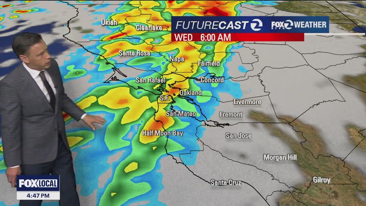
Our next storm is making its way closer to the Bay Area. The conditions will change rapidly overnight. The front will produce moderate to heavy rain for the Wednesday morning commute. The heaviest rain will be focused in the North Bay. Winds will also be an issue. High Wind Warnings and Wind Advisories have been issued for the majority of the Bay Area. Gusts could exceed 50 mph in some areas.
OAKLAND, Calif. - Tuesday's weather can be described as the proverbial calm before the storm. That's because pressure is building to make way for the rain and strong winds that are on the way.
Significant system
What we know:
This significant system will be noticed in the Bay Area first thing Wednesday morning. KTVU Chief Meteorologist Mark Tamayo says the rain band will make its way into the area, first targeting the North Bay, between 4 a.m. and 7 a.m. The heaviest rain from this system will be focused on San Francisco to the north.
"We have high-wind advisories and high-wind warnings posted for portions of the Bay Area," said Tamayo. He said the rainfall will greatly vary, with about a quarter inch in the South Bay, possibly over two inches of rain for the North Bay coastal hills."

Strong winds
Winds will be strong and blustery, ranging from 40 mph to greater than 60 mph.
"It is a defined wind out of the south," Tamayo said, describing the conditions at 6 a.m.
San Francisco is expecting up to 32 mph winds at that hour with 48 mph winds in Half Moon Bay. In Santa Rosa, they're looking at 36 mph winds.
The National Weather Service is saying the strongest winds will especially be along the coast and at higher elevations.
Tamayo said the overall trend is for the winds to scale back as the afternoon wears on. "The peak of the winds will be first thing Wednesday morning."
King Tides added to the mix
As if that weren't enough, the Bay Area also has a tidal flood advisory for Tuesday through Saturday, due to this week's king tides.
NWS says the Supermoon on Nov. 5 is expected to bring higher-than-usual tides, which can result in coastal flooding.
The added rainfall will combine with the swelling of the tide. "The peak will be Thursday morning just before 11 o'clock at the Golden Gate Bridge with 7.0 feet," Tamayo said.
Scaling back on rain expectation
Our meteorologists are scaling back on the initial rainfall expectations.
Travel impact
For Wednesday morning's commute, Tamayo says if you can avoid travel, that would be a good call. Otherwise, expect a longer commute because of the heavy rain and strong wind.
The California Governor's Office of Emergency Services is getting the word out on how to plan ahead, sign up for emergency alerts and to map out evacuation routes if need be. It's also important to keep phones charged and flashlights ready. You can find the Caltrans QuickMap Travel Alert here.
When does it pass?
"It's not going to be like this all day. Things kind of go away by 10 o'clock," says Tamayo. He said there could be a chance of scattered rain and isolated thunderstorms as the system pushes through the area. "By 4 o'clock some breaks in the clouds."
Looking ahead, there is a slight chance of rain showers on Thursday. Friday and Saturday are looking clear.
Featured

November stargazing guide: Brightest Supermoon of the year, dazzling pair of meteor showers
November kicks off with a midweek Supermoon, dubbed the Full Beaver Moon, on Nov. 5 that you will not want to miss.