

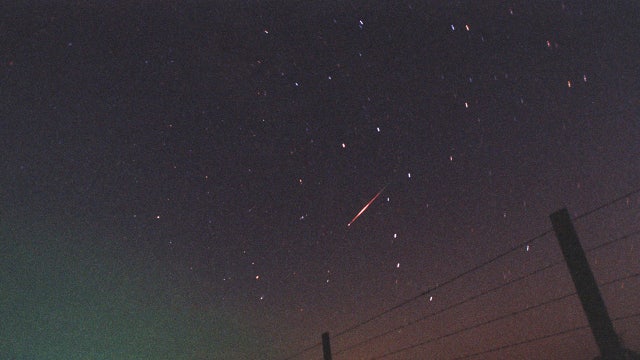

Look up tonight—the Leonid meteor shower will peak again under clear skies
The Leonid meteor shower will peak again tonight and stargazers will have a great opportunity to see the celestial show thanks to clearer skies.
The Leonid meteor shower will peak again tonight and stargazers will have a great opportunity to see the celestial show thanks to clearer skies.


More rain, temps in 60s
More rain, temps in 60s.
More rain, temps in 60s.


Heavy rain returns late Sunday
Our next storm is scheduled to move into the Bay Area late Sunday night - early Monday morning. As the defined frontal band moves in, moderate to heavy rain will spread south across the Bay Area. Stronger winds are also expected. Gusts could approach 40 mph. Occasional rain could still be a factor through Monday morning. Showers should taper later in the day.
Our next storm is scheduled to move into the Bay Area late Sunday night - early Monday morning. As the defined frontal band moves in, moderate to heavy rain will spread south across the Bay Area. Stronger winds are also expected. Gusts could approach 40 mph. Occasional rain could still be a factor through Monday morning. Showers should taper later in the day.


Bay Area hit twice by the same storm system; new cold front arrives tonight
A storm system is expected to bring moderate to heavy rain and gusty winds to the Bay Area starting Sunday night.
A storm system is expected to bring moderate to heavy rain and gusty winds to the Bay Area starting Sunday night.


Mainly dry today before another storm tonight
Morning showers will diminish, but another storm arrives tonight with a round of heavy rain, gusty winds, and a slight thunderstorm risk. Wind prone areas could see 35 mph gusts. Showers and isolated thunderstorms stick around Monday before we dry out Monday night and Tuesday.
Morning showers will diminish, but another storm arrives tonight with a round of heavy rain, gusty winds, and a slight thunderstorm risk. Wind prone areas could see 35 mph gusts. Showers and isolated thunderstorms stick around Monday before we dry out Monday night and Tuesday.


Cold Storm Sunday Night!
- Light rain spreading across the region from south to north today. Highest totals from Monterey Bay southward. - Alhough there will be a spotty, isolated Sunday shower, the next system on track for late Sunday is a strong cold front and a period of moderate-to-heavy rain overnight into Monday morning. Slight chance of thunderstorms Monday morning. Monday afternoon calms with cloudy skies and cool temps only in the 50s to low 60s. - Drier Tuesday with increasing clouds and a slight chance of rain Tuesday night with chilly temperatures through the rest of the week.
- Light rain spreading across the region from south to north today. Highest totals from Monterey Bay southward. - Alhough there will be a spotty, isolated Sunday shower, the next system on track for late Sunday is a strong cold front and a period of moderate-to-heavy rain overnight into Monday morning. Slight chance of thunderstorms Monday morning. Monday afternoon calms with cloudy skies and cool temps only in the 50s to low 60s. - Drier Tuesday with increasing clouds and a slight chance of rain Tuesday night with chilly temperatures through the rest of the week.


Mostly cloudy, showers increasing
Our active weather pattern continues. Mostly cloudy skies for most today. Light rain over the South Bay will spread north later today. Afternoon highs will range from the low to mid 60s. A brief break in the wet weather tomorrow before the next storm arrives later in the day.
Our active weather pattern continues. Mostly cloudy skies for most today. Light rain over the South Bay will spread north later today. Afternoon highs will range from the low to mid 60s. A brief break in the wet weather tomorrow before the next storm arrives later in the day.


Wet Weekend Ahead!
- Active weather pattern will continue this weekend and into the middle of next weekend. - Noticeably cooler conditions late weekend into next week. The forecast remains on track this evening with mostly cloudy skies and cooler temperatures from the mid and upper 40s to the low 50s. Both Saturday and Sunday there will be periods of widely scattered showers. The weekend will not be a washout, just anticipate an occasional shower, especially in the South Bay through the Santa Cruz Mountains. Morgan Hill and Gilroy will be wet too. Computer modules suggest at this time, the most probable time for the heaviest rain will be Sunday overnight to Monday morning. Plan on rain through most of next week!
- Active weather pattern will continue this weekend and into the middle of next weekend. - Noticeably cooler conditions late weekend into next week. The forecast remains on track this evening with mostly cloudy skies and cooler temperatures from the mid and upper 40s to the low 50s. Both Saturday and Sunday there will be periods of widely scattered showers. The weekend will not be a washout, just anticipate an occasional shower, especially in the South Bay through the Santa Cruz Mountains. Morgan Hill and Gilroy will be wet too. Computer modules suggest at this time, the most probable time for the heaviest rain will be Sunday overnight to Monday morning. Plan on rain through most of next week!


Bay Area walloped by powerful storm, more wet weather ahead
A powerful Pacific storm swept across the Bay Area on Thursday, bringing heavy rain, damaging winds, and widespread travel disruptions. The atmospheric river–fueled system delivered some of the highest early-season rainfall totals the region has seen in years — helping push this November toward the record books.
A powerful Pacific storm swept across the Bay Area on Thursday, bringing heavy rain, damaging winds, and widespread travel disruptions. The atmospheric river–fueled system delivered some of the highest early-season rainfall totals the region has seen in years — helping push this November toward the record books.


Mix of sun and clouds
Today will see a mix of sun and clouds. Possible rain to the south.
Today will see a mix of sun and clouds. Possible rain to the south.


Storm is moving out
The Thursday storm is moving out of town. Umbrellas should still be on standby. Lingering moisture and instability will lead to the chance of isolated showers in the Friday forecast. By Saturday, the chance of showers will be focused in the South Bay. Another system will boost rainfall chances later in the day on Sunday.
The Thursday storm is moving out of town. Umbrellas should still be on standby. Lingering moisture and instability will lead to the chance of isolated showers in the Friday forecast. By Saturday, the chance of showers will be focused in the South Bay. Another system will boost rainfall chances later in the day on Sunday.


It Has Arrived!
The storm has lived up to its expectations! Anywhere from an inch of rain to nearly 4.5 inchs of precipatation has accumulated so far today in the Bay Area. Highest wind recorded was at Cobb Ridge in Lake County at 63 mph. The High Wind Warning has allowed to expire with the Wind Advisory in effect until 3 PM as well as a Flood Advisory for SF, San Mateo and Santa Clara counties. A Beach Hazard Alert is in effect until Friday night for waves peaking at 18 feet and sneaker waves. Spotty showers late this afternoon through the evening with an isolated showetr on Friday. Highs in the 60s.
The storm has lived up to its expectations! Anywhere from an inch of rain to nearly 4.5 inchs of precipatation has accumulated so far today in the Bay Area. Highest wind recorded was at Cobb Ridge in Lake County at 63 mph. The High Wind Warning has allowed to expire with the Wind Advisory in effect until 3 PM as well as a Flood Advisory for SF, San Mateo and Santa Clara counties. A Beach Hazard Alert is in effect until Friday night for waves peaking at 18 feet and sneaker waves. Spotty showers late this afternoon through the evening with an isolated showetr on Friday. Highs in the 60s.


3.6-magnitude earthquake in Vallejo
An earthquake with a magnitude of 3.6 struck near Vallejo on Thursday afternoon, according to the US Geological Survey.
An earthquake with a magnitude of 3.6 struck near Vallejo on Thursday afternoon, according to the US Geological Survey.
Bay Area weather: Crashes, slow traffic during rainy morning commute
Early morning traffic Thursday was sluggish and dangerous for some, as drivers gripped their steering wheels trying to avoid crashes, which were prevalent during the rainy commute.
Early morning traffic Thursday was sluggish and dangerous for some, as drivers gripped their steering wheels trying to avoid crashes, which were prevalent during the rainy commute.
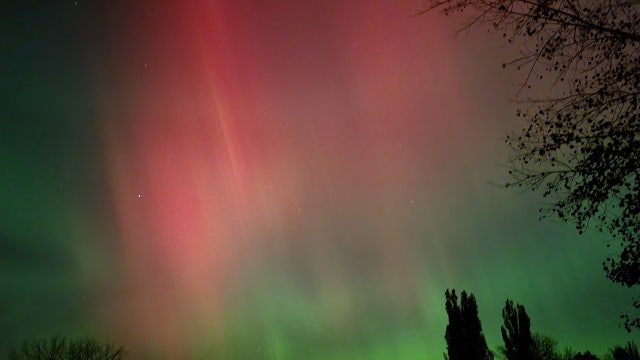

Look up tonight, Northern Lights may once again dazzle the night sky: Here's where
On Wednesday night, the northern lights once again dazzled the night sky. Tonight, parts of the U.S. have another chance to see the celestial show.
On Wednesday night, the northern lights once again dazzled the night sky. Tonight, parts of the U.S. have another chance to see the celestial show.


Rain, wind, thunderstorms
Rain, wind and thunderstorms expected today.
Rain, wind and thunderstorms expected today.


Wind whiplash, drenching downpours
- Strong southerly wind gusts up to 50-60 mph may cause property damage, downed tree limbs and difficult travel conditions Wind Advisory extended through 4 PM Thursday for areas south of the Golden Gate. The Wind Advisory and High Wind Warning for the North Bay, San Francisco and San Francisco Peninsula remain the same and will end at 10 AM Thursday. Rain moves through the Bay Area from 4 AM-10 AM Thursday with a chance of tstorms, greatly impacting the morning commute. For those commuting in the morning, be prepared for rain and consider allowing extra time for your commute. Rain and a chance of tstorms will continue to progress to the south and inland with precipitation increasing in the Santa Cruz Mountains and areas of the South Bay by 7 AM through 1 PM Thursday. Rain amounts: Up to 5 inches North Bay Coastal Mtns. Expect 1 to 2.5 inches of rain in the North Bay. There will be 1 to 1.5 inches SF, Peninsula and Central Bay and up to 1.25 inches of rain elsewhere. WIND is a BIG part of the story!
- Strong southerly wind gusts up to 50-60 mph may cause property damage, downed tree limbs and difficult travel conditions Wind Advisory extended through 4 PM Thursday for areas south of the Golden Gate. The Wind Advisory and High Wind Warning for the North Bay, San Francisco and San Francisco Peninsula remain the same and will end at 10 AM Thursday. Rain moves through the Bay Area from 4 AM-10 AM Thursday with a chance of tstorms, greatly impacting the morning commute. For those commuting in the morning, be prepared for rain and consider allowing extra time for your commute. Rain and a chance of tstorms will continue to progress to the south and inland with precipitation increasing in the Santa Cruz Mountains and areas of the South Bay by 7 AM through 1 PM Thursday. Rain amounts: Up to 5 inches North Bay Coastal Mtns. Expect 1 to 2.5 inches of rain in the North Bay. There will be 1 to 1.5 inches SF, Peninsula and Central Bay and up to 1.25 inches of rain elsewhere. WIND is a BIG part of the story!


Atmospheric river reaches Bay Area: What to expect
Strong southerly winds will be a major factor for much of the Bay Area when the storm arrives.
Strong southerly winds will be a major factor for much of the Bay Area when the storm arrives.


Here's how much warmer your winter has gotten since 1970
Winter is now the U.S.’s fastest-warming season. Here’s how much warmer your winter has gotten since 1970, according to new data.
Winter is now the U.S.’s fastest-warming season. Here’s how much warmer your winter has gotten since 1970, according to new data.


Timeline: Atmospheric river approaches Bay Area
An atmospheric river is headed for the Bay Area, bringing heavy rainfall and strong winds beginning late Wednesday and lasting through early Friday. The storm system is expected to deepen as it slides down the West Coast.
An atmospheric river is headed for the Bay Area, bringing heavy rainfall and strong winds beginning late Wednesday and lasting through early Friday. The storm system is expected to deepen as it slides down the West Coast.