Timeline: Atmospheric river approaches Bay Area
An atmospheric river is headed for the Bay Area, bringing heavy rainfall and strong winds beginning late Wednesday and lasting through early Friday. The storm system is expected to deepen as it slides down the West Coast.
An atmospheric river is headed for the Bay Area, bringing heavy rainfall and strong winds beginning late Wednesday and lasting through early Friday. The storm system is expected to deepen as it slides down the West Coast.
Atmospheric river approaches the Bay Area
Forecasters say an atmospheric river is headed toward the Bay Area, arriving late Wednesday. The system is expected to bring moderate rain, strong southerly winds, and a slight chance of thunderstorms through early Thursday.
Forecasters say an atmospheric river is headed toward the Bay Area, arriving late Wednesday. The system is expected to bring moderate rain, strong southerly winds, and a slight chance of thunderstorms through early Thursday.
The Storm Is On Approach!
- Unsettled weather pattern returns Wednesday - Moderate rain, strong southerly winds, and a slight chance for thunderstorms late Wednesday through early Thursday - Wind Advisory in effect from 10 PM Wednesday through 10 AM Thursday for the interior Bay Area and Central Coast. Mostly Cloudy tonight with drizzle possible. Overnight lows in the 40s. For Wednesday, mostly cloudy with few sunny breaks, a spotty shower possible. High in the 60s to 71 degrees.The leadig edge of the atmospheric river will impact the Bay Area before midnight in the North Bay. The worse of the rain will impact Thursday Morning Commute. As for winds, a Wind Advisory from 10 PM Wednesday through 10 AM Thursday for the interior Bay Area and Central Coast for southerly winds of 15 to 25 mph with gusts up to 45 mph. Wind gusts up to 55 mph are expected along the coast and in the higher elevations. Gusts have the potential to exceed 60 mph in the region`s peaks, favored gaps, and passes. Please plan accordingly!
- Unsettled weather pattern returns Wednesday - Moderate rain, strong southerly winds, and a slight chance for thunderstorms late Wednesday through early Thursday - Wind Advisory in effect from 10 PM Wednesday through 10 AM Thursday for the interior Bay Area and Central Coast. Mostly Cloudy tonight with drizzle possible. Overnight lows in the 40s. For Wednesday, mostly cloudy with few sunny breaks, a spotty shower possible. High in the 60s to 71 degrees.The leadig edge of the atmospheric river will impact the Bay Area before midnight in the North Bay. The worse of the rain will impact Thursday Morning Commute. As for winds, a Wind Advisory from 10 PM Wednesday through 10 AM Thursday for the interior Bay Area and Central Coast for southerly winds of 15 to 25 mph with gusts up to 45 mph. Wind gusts up to 55 mph are expected along the coast and in the higher elevations. Gusts have the potential to exceed 60 mph in the region`s peaks, favored gaps, and passes. Please plan accordingly!
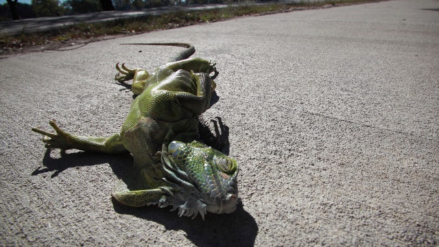
Arctic blast cold-stuns iguanas in Florida during record-setting temperature plunge
A frozen iguana was spotted in Boca Raton, Florida on Tuesday, as the coldest air of the season spread across the eastern U.S., setting several low temperatures across the Sunshine State.
A frozen iguana was spotted in Boca Raton, Florida on Tuesday, as the coldest air of the season spread across the eastern U.S., setting several low temperatures across the Sunshine State.
San Francisco weather: Atmospheric river to bring strong winds, thunderstorms
The National Weather Service warned that an atmospheric river is expected to bring strong winds, moderate to heavy rain, and a small chance of thunderstorms across the Bay Area beginning late Wednesday and lasting through Thursday.
The National Weather Service warned that an atmospheric river is expected to bring strong winds, moderate to heavy rain, and a small chance of thunderstorms across the Bay Area beginning late Wednesday and lasting through Thursday.
Morning sun, then clouds
Today will see morning sun with increasing clouds in the afternoon. Rain ahead for Wednesday.
Today will see morning sun with increasing clouds in the afternoon. Rain ahead for Wednesday.
Enjoyable Veteran's Day weather precedes mid-week storm
Veteran's Day will offer our final day of unseasonably warm temperatures before stormy weather returns, bringing heavy rain, breezy to windy conditions and snow to the Sierra on Wednesday into Thursday.
Veteran's Day will offer our final day of unseasonably warm temperatures before stormy weather returns, bringing heavy rain, breezy to windy conditions and snow to the Sierra on Wednesday into Thursday.
Farmers' Almanac saying goodbye after more than 200 years in publication
Editor's note: When this story was originally published, an image of the "Old Farmer's Almanac" was used.
Editor's note: When this story was originally published, an image of the "Old Farmer's Almanac" was used.
Mostly fair and warm
Today will be mostly fair and warm. Highs could reach 80.
Today will be mostly fair and warm. Highs could reach 80.
Our warm stretch continues
You can count on another round of warm temperatures in the Monday forecast. Highs should range from the low 70s to the low 80s. Slightly cooler temperatures in the Veterans Day forecast. We are tracking a pattern change later in the week. The storm door could open up Wednesday afternoon - evening. Rainfall rates will be going up early Thursday. Winds could also be a factor as this storm drifts closer to the coast.
You can count on another round of warm temperatures in the Monday forecast. Highs should range from the low 70s to the low 80s. Slightly cooler temperatures in the Veterans Day forecast. We are tracking a pattern change later in the week. The storm door could open up Wednesday afternoon - evening. Rainfall rates will be going up early Thursday. Winds could also be a factor as this storm drifts closer to the coast.
170 million Americans brace for deep freeze as temps plunge near record lows, even in Florida
Over 100 million Americans from Boston to Tampa, will get an early taste of winter this week, thanks to a sweeping cold front that will bring the coldest air of the season starting Sunday and lasting into next week.
Over 100 million Americans from Boston to Tampa, will get an early taste of winter this week, thanks to a sweeping cold front that will bring the coldest air of the season starting Sunday and lasting into next week.
Savoring the sunshine
Under mostly sunny skies, afternoon highs will soar into the upper 70s to low 80s today. The unseasonably warm weather is sticking around through Tuesday before cooler, wet weather returns later this week.
Under mostly sunny skies, afternoon highs will soar into the upper 70s to low 80s today. The unseasonably warm weather is sticking around through Tuesday before cooler, wet weather returns later this week.
Warmer Sunday
Our fair weather stretch continues! A few high clouds could move into the area Sunday. Highs should range from the low 70s to the low 80s. The pattern will be changing next week. Rain chances will be increasing Wednesday. The wet weather pattern may last through Friday.
Our fair weather stretch continues! A few high clouds could move into the area Sunday. Highs should range from the low 70s to the low 80s. The pattern will be changing next week. Rain chances will be increasing Wednesday. The wet weather pattern may last through Friday.
Unseasonably warm weekend
Mostly sunny, unseasonably warm weather is expected this afternoon. Temperatures will range from upper 60s to upper 70s inland. Even a tad warmer for your Bay Area Sunday. A Coastal Flood Advisory for low lying areas adjacent to the Bay remains in place until 2 PM.
Mostly sunny, unseasonably warm weather is expected this afternoon. Temperatures will range from upper 60s to upper 70s inland. Even a tad warmer for your Bay Area Sunday. A Coastal Flood Advisory for low lying areas adjacent to the Bay remains in place until 2 PM.
Plan On Fun In The Sun!
- Warming and drying trend through this upcoming Monday - Tidally influenced coastal flooding and hazardous beach conditions continue through Saturday - Unsettled weather pattern returns by the middle of next week For tonight, valley and wind sheltered locations will drop into the upper 40s with low-to-mid 50s elsewhere. Low clouds are forecast to return tonight and more so into Saturday morning in the North Bay and Bay Area as a shallow marine layer remains in place. Offshore flow will increase slightly in the higher terrain overnight, further drying out conditions. However, recent rainfall and generally weak north/northeast winds will limit fire weather concerns. Warmer conditions are forecast for Saturday. Temperatures both days with be 5-15 degrees above normal for this time of year with mid 70s to mid 80s across the interior with the Bay Shoreline and the Santa Cruz region reaching into the low 70s to low 80s.
- Warming and drying trend through this upcoming Monday - Tidally influenced coastal flooding and hazardous beach conditions continue through Saturday - Unsettled weather pattern returns by the middle of next week For tonight, valley and wind sheltered locations will drop into the upper 40s with low-to-mid 50s elsewhere. Low clouds are forecast to return tonight and more so into Saturday morning in the North Bay and Bay Area as a shallow marine layer remains in place. Offshore flow will increase slightly in the higher terrain overnight, further drying out conditions. However, recent rainfall and generally weak north/northeast winds will limit fire weather concerns. Warmer conditions are forecast for Saturday. Temperatures both days with be 5-15 degrees above normal for this time of year with mid 70s to mid 80s across the interior with the Bay Shoreline and the Santa Cruz region reaching into the low 70s to low 80s.
Partly sunny, warmer
Today will be partly sunny and warmer with temps in the 60s and 70s.
Today will be partly sunny and warmer with temps in the 60s and 70s.
Weak system early Friday
A weak system will approach the Bay Area Friday morning While the main energy will be focused to the north, a few showers could develop in the North Bay Friday morning. We are expecting a mixture of sun and clouds later in the day. The weekend will be dry. Warmer temps (70s and 80s) will be paying us a visit.
A weak system will approach the Bay Area Friday morning While the main energy will be focused to the north, a few showers could develop in the North Bay Friday morning. We are expecting a mixture of sun and clouds later in the day. The weekend will be dry. Warmer temps (70s and 80s) will be paying us a visit.
Wait For it.....A Warmer and Sunnier Weekend!
-Light rain showers chances linger over the North Bay and San Mateo Peninsula Coast overnight through Friday morning -Tidal influenced coastal flooding (Kings Tides) and Hazardous Beach Alert in effect through Saturday. Dangerous sneaker waves and rip currents are present. conditions continue through the early Weekend. -Pleasant weather this weekend will yield to unsettled weather pattern after Veterans day next week Mixed bag across the forecast area this morning, either sunshine or clouds/patchy fog. Quite the change from yesterday morning where it was wet and windy. Much less wind and more sunshine today! Thinking some isolated showers will return tonight and will leave those in the forecast for the far North Bay. Dry weather and warmer weather (near 80 degrees) over the weekend!
-Light rain showers chances linger over the North Bay and San Mateo Peninsula Coast overnight through Friday morning -Tidal influenced coastal flooding (Kings Tides) and Hazardous Beach Alert in effect through Saturday. Dangerous sneaker waves and rip currents are present. conditions continue through the early Weekend. -Pleasant weather this weekend will yield to unsettled weather pattern after Veterans day next week Mixed bag across the forecast area this morning, either sunshine or clouds/patchy fog. Quite the change from yesterday morning where it was wet and windy. Much less wind and more sunshine today! Thinking some isolated showers will return tonight and will leave those in the forecast for the far North Bay. Dry weather and warmer weather (near 80 degrees) over the weekend!
Mix of clouds and sun
Today will see a mix of clouds and sun.
Today will see a mix of clouds and sun.
A break from the rain
The Wednesday rain and wind event is winding down. Low clouds will blanket most of the Bay Area Thursday morning. Partly cloudy skies are expected later in the day. A weak system will bring in more clouds Thursday night. The chance of showers will favor the North Bay late Thursday. We are expecting a mixture of sun and clouds this weekend.
The Wednesday rain and wind event is winding down. Low clouds will blanket most of the Bay Area Thursday morning. Partly cloudy skies are expected later in the day. A weak system will bring in more clouds Thursday night. The chance of showers will favor the North Bay late Thursday. We are expecting a mixture of sun and clouds this weekend.


