


Temperatures to soar this weekend
Dangerous temperatures in the triple digits are expected this weekend for some inland parts. The dangerous weather is accompanied by excessive heat warnings. Thanks to micro-climates, the coast will see mid-60s to mid 70s.
Dangerous temperatures in the triple digits are expected this weekend for some inland parts. The dangerous weather is accompanied by excessive heat warnings. Thanks to micro-climates, the coast will see mid-60s to mid 70s.


Record heat, Spare the Air day
Weekend daytime temperatures across much of the Bay Area will stay dangerously high, with an Excessive Heat Watch in place through Sunday.
Weekend daytime temperatures across much of the Bay Area will stay dangerously high, with an Excessive Heat Watch in place through Sunday.


Another inland scorcher, but cool thoughts ahead
Sunday will be another hot day around the Bay Area. Temperatures will start to cool Monday and Tuesday.
Sunday will be another hot day around the Bay Area. Temperatures will start to cool Monday and Tuesday.


Triple digit heat to roast the Bay Area this weekend
KTVU meteorologist Mark Tamayo gives the latest in weather forecast. The Bay Area is expected to face hot temperatures that will persist for several days.
KTVU meteorologist Mark Tamayo gives the latest in weather forecast. The Bay Area is expected to face hot temperatures that will persist for several days.


Slightly cooler temperatures sweep Bay Area
KTVU's Rosemary Orozco shares the Monday noon forecast, following the weekend's soaring triple-digit temperatures.
KTVU's Rosemary Orozco shares the Monday noon forecast, following the weekend's soaring triple-digit temperatures.


Temps could top 100
Steve Paulson says temps could top 100 degrees.
Steve Paulson says temps could top 100 degrees.


Temps start to warm-up ahead of intense heat
Temperatures around the Bay Area will warm up Wednesday before the intense heat kicks in.
Temperatures around the Bay Area will warm up Wednesday before the intense heat kicks in.


Cooling slightly
Steve Paulson says today will be slightly cooler with temps ranging from 64 to 98 degrees.
Steve Paulson says today will be slightly cooler with temps ranging from 64 to 98 degrees.


Bay Area braces for weekend's triple digit heat
KTVU's Mark Tamayo unpacks the intense heat coming up this weekend and shares advice on how to stay cool.
KTVU's Mark Tamayo unpacks the intense heat coming up this weekend and shares advice on how to stay cool.


Warming trend
Wall-to-wall sun. Temps in 70s and 80s.
Wall-to-wall sun. Temps in 70s and 80s.


Warmer Tuesday forecast
A dry weather pattern will pay us a visit this week. Your Tuesday forecast features warmer temperatures. Highs should range from the upper 60s to the low 80s. Wednesday should be the warmest day of the week. The Halloween forecast looks great for all of the ghosts and goblins Friday evening.
A dry weather pattern will pay us a visit this week. Your Tuesday forecast features warmer temperatures. Highs should range from the upper 60s to the low 80s. Wednesday should be the warmest day of the week. The Halloween forecast looks great for all of the ghosts and goblins Friday evening.


Warmer, dryer temps expected this week.
Wet and cloudy conditions are moving out of the Bay Area, and residents can expect warmer weather as we approach November.
Wet and cloudy conditions are moving out of the Bay Area, and residents can expect warmer weather as we approach November.
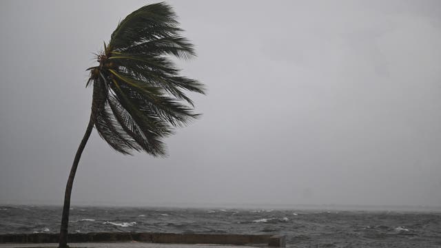

Hurricane Melissa slams toward Jamaica as powerful Category 5 storm
Hurricane Melissa intensified to Category 5 strength Monday as it neared Jamaica. Forecasters said it would be the strongest hurricane to hit the island since record keeping began in 1851.
Hurricane Melissa intensified to Category 5 strength Monday as it neared Jamaica. Forecasters said it would be the strongest hurricane to hit the island since record keeping began in 1851.


Rain clouds moving out
The weekend clouds will be moving out of the Bay Area. We are heading into a sunny, mild pattern. Mostly sunny skies will highlight your Monday forecast. Highs should range from the low 60s to the low 70s. The mild to warm stretch will remain in place through Halloween.
The weekend clouds will be moving out of the Bay Area. We are heading into a sunny, mild pattern. Mostly sunny skies will highlight your Monday forecast. Highs should range from the low 60s to the low 70s. The mild to warm stretch will remain in place through Halloween.
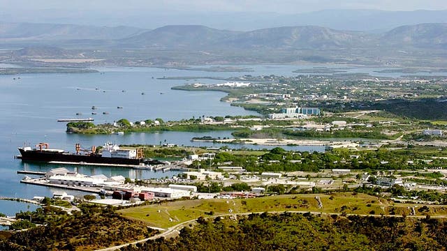

Guantánamo Bay begins evacuations as Hurricane Melissa nears category 5 strength
As Hurricane Melissa intensifies into a powerful Category 4 storm with the potential to reach Category 5 strength, U.S. authorities at Naval Station Guantánamo Bay, Cuba, have begun evacuating non-mission-essential U.S. citizens.
As Hurricane Melissa intensifies into a powerful Category 4 storm with the potential to reach Category 5 strength, U.S. authorities at Naval Station Guantánamo Bay, Cuba, have begun evacuating non-mission-essential U.S. citizens.


Mostly cloudy with passing showers today
Cloudy, breezy, showery weather today. Widespread 60s can be expected for the afternoon. Drying out and warming up for the week ahead.
Cloudy, breezy, showery weather today. Widespread 60s can be expected for the afternoon. Drying out and warming up for the week ahead.

Hurricane Melissa sees extreme rapid intensification as Jamaica braces for extensive infrastructural damage
Time has essentially run out for millions of people in Jamaica to prepare for deadly Hurricane Melissa’s onslaught as the monster storm undergoes "extreme rapid intensification" ahead of its likely catastrophic landfall in the coming days.
Time has essentially run out for millions of people in Jamaica to prepare for deadly Hurricane Melissa’s onslaught as the monster storm undergoes "extreme rapid intensification" ahead of its likely catastrophic landfall in the coming days.


Wet weekend!
As expected, the North Bay coastal ranges and inland hills/higher peaks picked up the most rainfall from today as a cold front move through the region. Rainfall amounts where anywhere from 0.25" to 0.75" with Mount Tamalpais picking up 1.16". The frontal boundary continues to move southward across the Central Coast with little to no measurable rainfall as the system continues to weaken. The exception being the hills of the San Francisco Peninsula and the Santa Cruz Mountains where up to 0.20" can be expected through the remainder of the day/evening. The far northern portions of the North Bay may have lingering post frontal rain showers this afternoon and will begin to taper off this evening. Cooler conditions are forecast for tonight with lows Sunday morning ranging from the mid 50s near the coast to upper 40s inland. A second frontal boundary will move through the North Bay Sunday morning through afternoon bringing about half the amount of rainfall to the region as today. The Bay Area and Santa Cruz Mountains may pick up just a few hundredths of an inch. Rainfall chances greatly diminish late Sunday evening across all of the region. Enjoy your Autumn Weekend! :fallen_leaf:
As expected, the North Bay coastal ranges and inland hills/higher peaks picked up the most rainfall from today as a cold front move through the region. Rainfall amounts where anywhere from 0.25" to 0.75" with Mount Tamalpais picking up 1.16". The frontal boundary continues to move southward across the Central Coast with little to no measurable rainfall as the system continues to weaken. The exception being the hills of the San Francisco Peninsula and the Santa Cruz Mountains where up to 0.20" can be expected through the remainder of the day/evening. The far northern portions of the North Bay may have lingering post frontal rain showers this afternoon and will begin to taper off this evening. Cooler conditions are forecast for tonight with lows Sunday morning ranging from the mid 50s near the coast to upper 40s inland. A second frontal boundary will move through the North Bay Sunday morning through afternoon bringing about half the amount of rainfall to the region as today. The Bay Area and Santa Cruz Mountains may pick up just a few hundredths of an inch. Rainfall chances greatly diminish late Sunday evening across all of the region. Enjoy your Autumn Weekend! :fallen_leaf:


Wet Weekend!
- Beneficial rain across the Bay Area arrives Saturday - Large swell has returned with hazardous beach conditions through the weekend - Warming and drying trend for next week! Tonight will be slightly warmer, especially across the North Bay and Bay Area as clouds continue to increase as the front approaches. Prefrontal rain will be possible early Saturday morning with main band moving through the North Bay between 3 AM and 7 AM, the Bay Area between 5 AM and 9 AM, the Santa Cruz Mountains and South Bay between 9 AM and 1 PM, and then the remainder of the Central Coast after 1 PM. Rainfall amounts will be beneficial across the North Bay with the coastal ranges picking up between 0.25"-0.50" with less than 0.20" in the valleys. Less than 0.10" in the city of San Francisco and little to nothing as you head southward and inland. Winds will be breezy to windy, southwest 10-20 mph with occasional stronger gusts. Bottom line...cloudy, cooler and breezy with a smattering of showers. Have a nice weekend!
- Beneficial rain across the Bay Area arrives Saturday - Large swell has returned with hazardous beach conditions through the weekend - Warming and drying trend for next week! Tonight will be slightly warmer, especially across the North Bay and Bay Area as clouds continue to increase as the front approaches. Prefrontal rain will be possible early Saturday morning with main band moving through the North Bay between 3 AM and 7 AM, the Bay Area between 5 AM and 9 AM, the Santa Cruz Mountains and South Bay between 9 AM and 1 PM, and then the remainder of the Central Coast after 1 PM. Rainfall amounts will be beneficial across the North Bay with the coastal ranges picking up between 0.25"-0.50" with less than 0.20" in the valleys. Less than 0.10" in the city of San Francisco and little to nothing as you head southward and inland. Winds will be breezy to windy, southwest 10-20 mph with occasional stronger gusts. Bottom line...cloudy, cooler and breezy with a smattering of showers. Have a nice weekend!


Fog and sun
Today will see fog and sun, clouds with rain on Saturday.
Today will see fog and sun, clouds with rain on Saturday.