


Fog returns
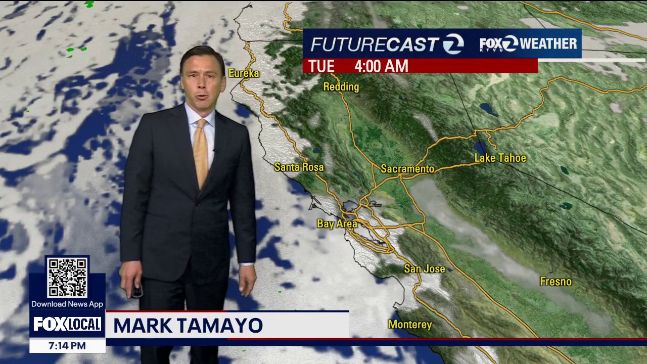
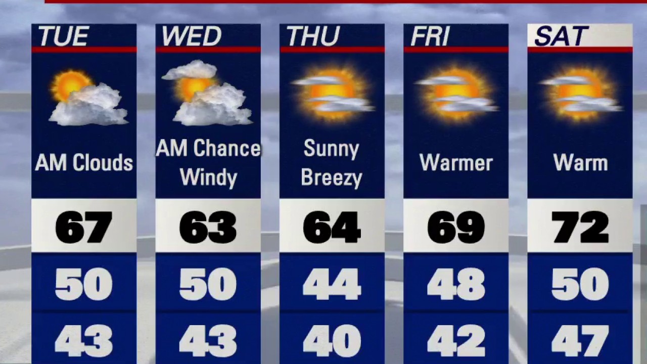
Low clouds and fog are expected to resurface Tuesday morning. Partly sunny skies will highlight the afternoon forecast. Highs should range from the mid to upper 60s. We are tracking a pattern change later in the week. Plan on windy conditions and warmer temperatures.
Low clouds and fog are expected to resurface Tuesday morning. Partly sunny skies will highlight the afternoon forecast. Highs should range from the mid to upper 60s. We are tracking a pattern change later in the week. Plan on windy conditions and warmer temperatures.

Quiet weather around the Bay, but changes coming
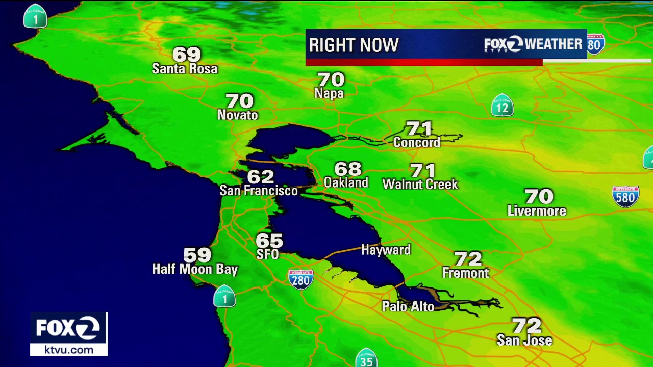
Chief meteorologist Mark Tamayo said weather around the Bay Area has been mild, but some changes are coming.
Chief meteorologist Mark Tamayo said weather around the Bay Area has been mild, but some changes are coming.


Chance of light overnight rain for the Bay Area
Temperatures are dropping, and a small amount of precipitation may arrive in the Bay Area early Monday morning.
Temperatures are dropping, and a small amount of precipitation may arrive in the Bay Area early Monday morning.


Cloudy, scattered sprinkles as storm system mostly bypasses Bay Area
A storm system is approaching, but is expected to move north and bypass many Bay Area communities.
A storm system is approaching, but is expected to move north and bypass many Bay Area communities.

Bay Area evening temperatures above average
Conditions on Saturday were a bit cooler than Friday's record-breaking temperatures.
Conditions on Saturday were a bit cooler than Friday's record-breaking temperatures.

Temps down, partly sunny conditions for the weekend
The North Bay may see some light precipitation, but weekend conditions are expected to be partly cloudy and temperate.
The North Bay may see some light precipitation, but weekend conditions are expected to be partly cloudy and temperate.


Record highs around parts of the Bay
Several cities saw record-breaking temperatures Friday, but cloud cover is moving in.
Several cities saw record-breaking temperatures Friday, but cloud cover is moving in.


Rattled San Ramon residents attend town hall over quakes
Hundreds of San Ramon residents attended a town hall Friday to talk about recent swarms of earthquakes that have rattled the region.
Hundreds of San Ramon residents attended a town hall Friday to talk about recent swarms of earthquakes that have rattled the region.


How a groundhog, a lion, and a lamb shape spring weather folklore
As we approach March and the first day of spring on March 20, will it come "In like a lion out like a lamb", and will we have six more weeks of winter like Punxsutawney Phil predicted on Groundhog Day?
As we approach March and the first day of spring on March 20, will it come "In like a lion out like a lamb", and will we have six more weeks of winter like Punxsutawney Phil predicted on Groundhog Day?


Magnitude 3.4 earthquake felt in the North Bay
A magnitude 3.4 earthquake struck in the North Bay on Thursday night, according to officials with the U.S. Geological Survey.
A magnitude 3.4 earthquake struck in the North Bay on Thursday night, according to officials with the U.S. Geological Survey.
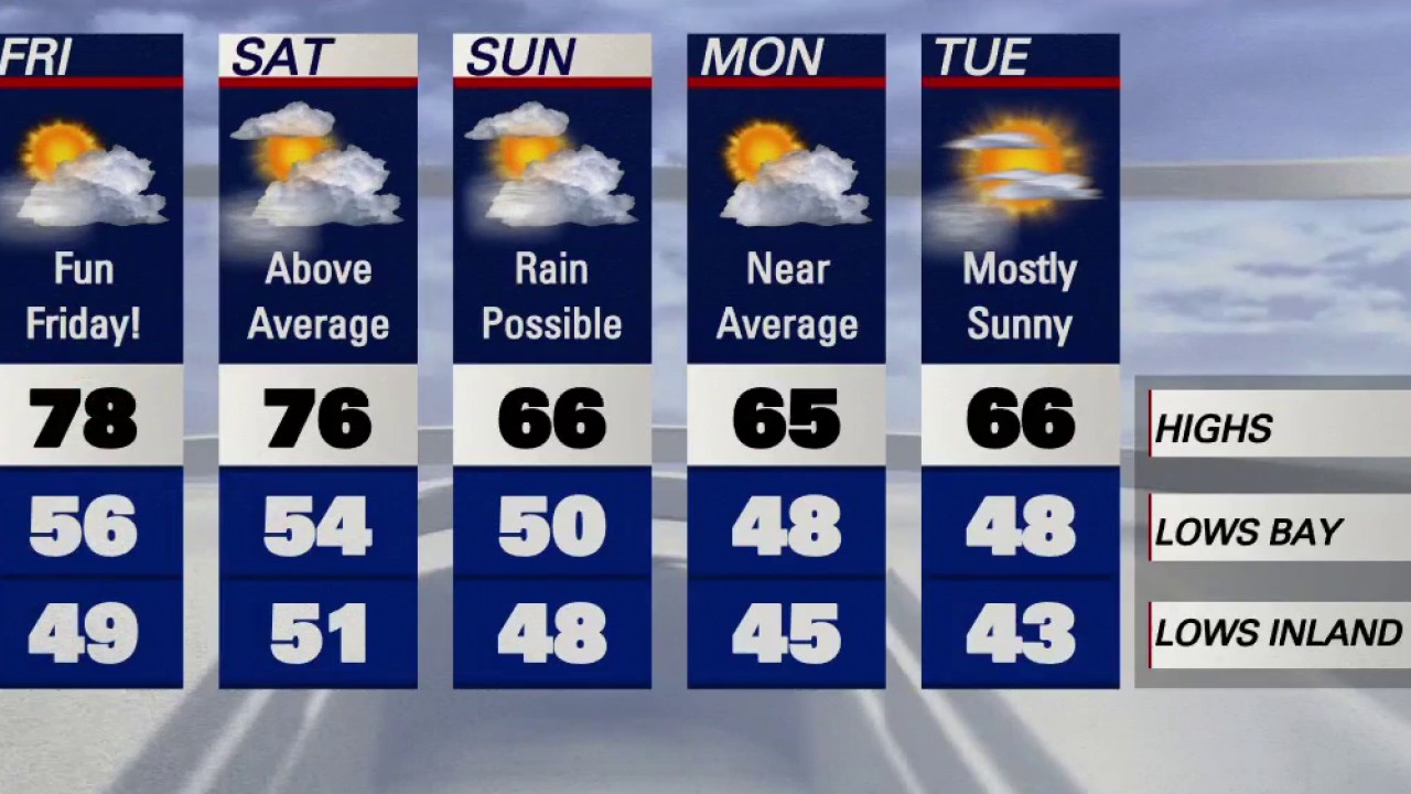

Friday expected to be warmest day of the week
Meteorologist Roberta Gonzales forecast warm temperatures around the Bay Area on Friday, saying it is expected to be the warmest day of the week.
Meteorologist Roberta Gonzales forecast warm temperatures around the Bay Area on Friday, saying it is expected to be the warmest day of the week.


College student found in snow-covered car dies of carbon monoxide poisoning during Rhode Island blizzard
A college student was found unconscious inside a snow-covered car during a Rhode Island blizzard and later died of carbon monoxide poisoning, the Newport Police Department said Tuesday.
A college student was found unconscious inside a snow-covered car during a Rhode Island blizzard and later died of carbon monoxide poisoning, the Newport Police Department said Tuesday.


Humid and warm
An unusually warm pattern has settled into the state. Temperatures will be well above average for Thursday and Friday. Dense fog will resurface just in time for the Thursday morning commute. Partly sunny skies are expected later in the day. Highs should range from the mid 60s to the mid 70s. Friday should be the warmest day of the week.
An unusually warm pattern has settled into the state. Temperatures will be well above average for Thursday and Friday. Dense fog will resurface just in time for the Thursday morning commute. Partly sunny skies are expected later in the day. Highs should range from the mid 60s to the mid 70s. Friday should be the warmest day of the week.


Mild to warm weather through rest of February
Meteorologist Roberta Gonzales said the Arctic blast the Bay Area experienced last week is gone, and mild to warm temperatures will stick around through the rest of February.
Meteorologist Roberta Gonzales said the Arctic blast the Bay Area experienced last week is gone, and mild to warm temperatures will stick around through the rest of February.
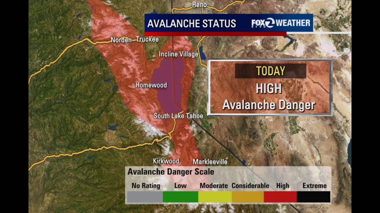

High avalanche danger persists for Lake Tahoe
While weather conditions have improved in Lake Tahoe, the coast isn’t clear yet, as some areas still face a high avalanche danger.
While weather conditions have improved in Lake Tahoe, the coast isn’t clear yet, as some areas still face a high avalanche danger.


Rain should clear up by afternoon
The rain should clear up by afternoon. Temps in the 60s.
The rain should clear up by afternoon. Temps in the 60s.


Rapid Tahoe warmup could accelerate snowmelt, raise flood concerns
After last week’s record snowfall, the greater Lake Tahoe area and the avalanche danger are still in effect, meaning residents should be wary of flooding as rapid warming moves into the Greater Lake Tahoe region.
After last week’s record snowfall, the greater Lake Tahoe area and the avalanche danger are still in effect, meaning residents should be wary of flooding as rapid warming moves into the Greater Lake Tahoe region.
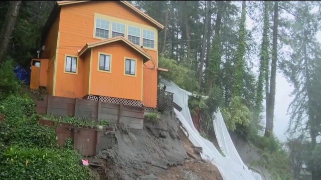

Guerneville house could collapse onto the road and other homes
This single, unoccupied home hangs precariously to a steep hillside, which it has done since Monday morning. There was a retaining wall and a parking spot construction going on at the time just below the home, as well as some tree removals.
This single, unoccupied home hangs precariously to a steep hillside, which it has done since Monday morning. There was a retaining wall and a parking spot construction going on at the time just below the home, as well as some tree removals.


Family ski trip ends in tragedy after brother finds sister swept away by Utah avalanche
A Massachusetts girl was skiing at a Utah ski resort when the avalanche struck on Feb. 19, according to police.
A Massachusetts girl was skiing at a Utah ski resort when the avalanche struck on Feb. 19, according to police.


Cool and clear night before mid-week rain arrives
Temperatures on Sunday night were comfortable, and conditions were expected to stay that way until late Monday.
Temperatures on Sunday night were comfortable, and conditions were expected to stay that way until late Monday.