

Heading to Hawaii this weekend? Tropical Storm Lala will dampen your travel plans
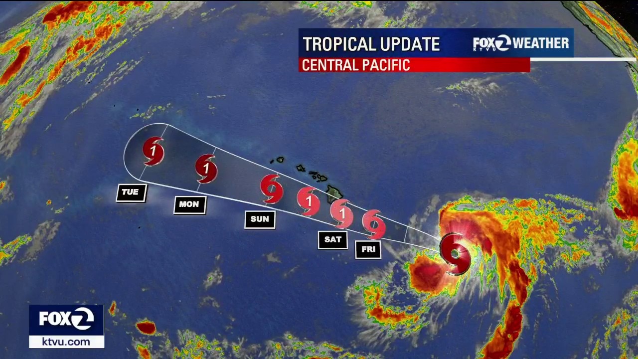
Tropical Storm Lala approaching Hawaii: What to know
The National Weather Service in Honolulu says the Big Island and islands of Maui County currently have the highest potential for heavy rainfall, although that forecast could change as the system develops and its track becomes clearer.
A tropical system approaching Hawaii is expected to bring heavy rain, damaging winds, flooding and dangerous surf to portions of the islands this weekend, with the Big Island and Maui currently among the areas of greatest concern.
The National Hurricane Center began issuing advisories Wednesday on Potential Tropical Cyclone One-C, which was located roughly 900 miles east-southeast of the Big Island at the time.
Tropical Storm Lala
The disturbance strengthened into Tropical Storm Lala by Wednesday night as it moved west-northwest toward the Hawaiian Islands.
Confidence is increasing that at least portions of Hawaii will feel impacts from the system this weekend, but uncertainty remains over how strong the storm will become and exactly where it will track. As of Thursday, Lala had maximum sustained winds of 45 mph and was about 650 miles from Hilo, Hawaii.
Big Island and Maui could see greatest rainfall threat
What we know:
The Central Pacific Hurricane Center forecasts Lala to strengthen into a hurricane as it approaches the Big Island.
The official forecast continues to take Lala west to west-northwest, bringing the center near or just south of the Big Island on Saturday before it tracks south of the smaller Hawaiian islands later in the weekend.
The National Weather Service in Honolulu says the Big Island and the islands of Maui County currently have the greatest potential for heavy rainfall, although the forecast could change as the storm develops and its track becomes clearer.
Periods of heavy tropical rain are possible, particularly along east- and southeast-facing slopes.
Hawaii's mountainous terrain could enhance rainfall as moisture-laden air is forced up the slopes. If bands of heavy rain repeatedly move over the same areas, flash flooding and rapidly rising streams could become a concern.

Hawaii tourism rebounding as travelers find new value opportunities
Hawaii’s tourism industry continues its post-pandemic recovery, with occupancy numbers climbing and travelers returning to the islands. Travel expert Gabe Saglie joined us from the Big Island to explain why this summer and beyond could offer a unique window for visitors looking for value, cultural experiences and conservation-focused adventures.
Strong, damaging winds possible even without a direct hit
Dig deeper:
The storm's exact track will also determine the extent of the wind threat.
Winds across portions of Hawaii could strengthen considerably Saturday. The National Weather Service says damaging winds could occur even if the storm's center remains away from the islands.
Forecasters also expect a large easterly swell to develop as the system approaches. Surf along east-facing shores could build from east to west, with warning-level surf of 15 feet or higher possible during the weekend.
Hurricane Hone showed how much rain Hawaii can receive without a direct hit
The backstory:
A recent hurricane illustrates why forecasters are closely watching the rainfall potential even if the developing storm’s center does not cross directly over an island.
In August 2024, Hurricane Hone passed within about 50 miles south of the Big Island, but its outer rain bands produced a prolonged period of heavy rainfall.
Several gauges along the windward and southeast-facing slopes of the Big Island measured more than 20 inches of rain in 48 hours.
Hakalau recorded 28.82 inches, Saddle Quarry measured 25.03 inches and Mountain View received 21.30 inches, according to the National Weather Service.
The rainfall caused road closures in low-lying areas. Hone also produced strong winds that knocked down trees and utility poles. More than 20,000 customers across Hawaii were without power at one point, with most of the outages occurring on the Big Island.
Hone is an example of how a tropical cyclone does not necessarily have to make landfall in Hawaii to produce significant impacts.
Central Pacific Hurricane season
Dig deeper:
The developing system comes during a season NOAA had already predicted would be more active than usual in the Central Pacific.
NOAA’s 2026 outlook calls for a 70% chance of an above-normal Central Pacific hurricane season, with five to 13 tropical cyclones expected. A near normal season typically produces four or five tropical cyclones.
KTVU forecasters say El Niño conditions expected during the hurricane season are one factor favoring increased tropical activity in the Central Pacific.
The Central Pacific hurricane season runs from June 1 through Nov. 30.
Residents and visitors across the Hawaiian Islands are being urged to closely monitor forecasts and prepare for possible tropical cyclone impacts this weekend. If you are traveling to Hawaii this weekend, monitor the weather closely, as conditions are wide-ranging and can change quickly.
The storm’s eventual strength, track and proximity to the islands will determine which areas experience the heaviest rainfall and strongest winds and forecasters expect those details to become clearer as the system becomes better organized.
A separate local weather note: There is also a 15% chance of isolated dry lightning or thunderstorms over the Big Sur region, including areas near the ongoing Timber Fire, as well as portions of the southern Bay Area through Thursday morning.
The Source: NHC/CPHC, NWS Honolulu Forecast Discussion, NWS Honolulu's Hurricane Hone summary, NOAA's 2026 Central Pacific Hurricane Season Outlook