


Chilly NYE temps
It's going to be cold today, with lows in the 40s as the New Year arrives.
It's going to be cold today, with lows in the 40s as the New Year arrives.


Brace for a frosty morning
KTVU meteorologist Bill Martin said the Bay Area will experience some frosty weather Tuesday morning.
KTVU meteorologist Bill Martin said the Bay Area will experience some frosty weather Tuesday morning.


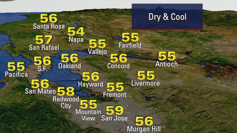
Cool start, no rain
Today will start off pretty chilly. No rain.
Today will start off pretty chilly. No rain.


Final storm of the year brings rain, mountain snow
The final storm of the year is expected to dump several inches of rain in the Bay Area and unload up to 12 inches of snow in the Tahoe mountains.
The final storm of the year is expected to dump several inches of rain in the Bay Area and unload up to 12 inches of snow in the Tahoe mountains.


Wet, windy start with a dry finish
The final storm of 2024 is bringing wet and windy weather for the first part of the day. Partly cloudy dry conditions will move in by the afternoon with temperatures ranging from upper 50s to low 60s. A Flood Watch is in effect for the North Bay until 12p, A Wind Advisory for most of the Bay Area will last until 3P. A Winter Weather Advisory for the Sierra is in effect until 8P.
The final storm of 2024 is bringing wet and windy weather for the first part of the day. Partly cloudy dry conditions will move in by the afternoon with temperatures ranging from upper 50s to low 60s. A Flood Watch is in effect for the North Bay until 12p, A Wind Advisory for most of the Bay Area will last until 3P. A Winter Weather Advisory for the Sierra is in effect until 8P.


Last storm of the year moves in Sunday
The last storm of 2024 is scheduled to arrive Sunday morning. Moderate to heavy rain will move across the Bay Area. Winds could approach 40 mph. We are expecting a mixture of sun and clouds during the afternoon. Once the rain moves out, a cold pattern settles in. A Frost Advisory will likely be issued for Tuesday morning. We should greet 2025 with dry and cool conditions. Happy New Year! -Mark
The last storm of 2024 is scheduled to arrive Sunday morning. Moderate to heavy rain will move across the Bay Area. Winds could approach 40 mph. We are expecting a mixture of sun and clouds during the afternoon. Once the rain moves out, a cold pattern settles in. A Frost Advisory will likely be issued for Tuesday morning. We should greet 2025 with dry and cool conditions. Happy New Year! -Mark


Unsettled weather and high surf today
Morning showers will taper off to mostly cloudy main dry conditions today. The High Surf Advisory for our coast continues until Sunday at 4AM. Widespread Bay Area Rain & Sierra snow returns on Sunday.
Morning showers will taper off to mostly cloudy main dry conditions today. The High Surf Advisory for our coast continues until Sunday at 4AM. Widespread Bay Area Rain & Sierra snow returns on Sunday.


High surf advisory
There's a high surf advisory in effect through Sunday.
There's a high surf advisory in effect through Sunday.


Rain returns early Friday
Here's the latest forecast from the KTVU weather team.
Here's the latest forecast from the KTVU weather team.


Winter weather advisory, rain
There's a winter weather advisory for the mountains until noon on Friday. Rain will be heaviest Thursday night.
There's a winter weather advisory for the mountains until noon on Friday. Rain will be heaviest Thursday night.


Christmas forecast: No rain
KTVU meteorologist Roberta Gonzalez forecast chilly temperatures around the Bay Area. On the bright side, there was no rain on Christmas; however, a wet weather system is moving in.
KTVU meteorologist Roberta Gonzalez forecast chilly temperatures around the Bay Area. On the bright side, there was no rain on Christmas; however, a wet weather system is moving in.

Cold start to Christmas morning, but dry
KTVU meteorologist Rosemary Orozco said Christmas Day will be dry, but another wet weather system is headed for the Bay Area.
KTVU meteorologist Rosemary Orozco said Christmas Day will be dry, but another wet weather system is headed for the Bay Area.


Dangerous surf, rain will taper off
Today still has dangerous surf. Rain will taper off through the day.
Today still has dangerous surf. Rain will taper off through the day.


Next storm moving in
Heavy rain and the risk of thunderstorms will roll in overnight and continue for the first half of Tuesday before clearing skies for the second half of the day. A High Surf Warning continues for the coast until 6 PM Tuesday for hazardous conditions both in and out of the water.
Heavy rain and the risk of thunderstorms will roll in overnight and continue for the first half of Tuesday before clearing skies for the second half of the day. A High Surf Warning continues for the coast until 6 PM Tuesday for hazardous conditions both in and out of the water.


Mostly cloudy, random showers
Today will be mostly cloudy with random showers.
Today will be mostly cloudy with random showers.


Wet weather and high surf
Mostly cloudy skies with a chance of showers will continue today before a round of steady, heavier rain arrives tonight. Afternoon highs will range from upper 50s to upper 60s. A building west swell will create dangerous conditions for our coast through Tuesday. Mainly dry weather is expected on Monday before the strongest storm in this series arrives on Tuesday.
Mostly cloudy skies with a chance of showers will continue today before a round of steady, heavier rain arrives tonight. Afternoon highs will range from upper 50s to upper 60s. A building west swell will create dangerous conditions for our coast through Tuesday. Mainly dry weather is expected on Monday before the strongest storm in this series arrives on Tuesday.


A break in the rain
The first system will move out of the Bay Area overnight. Your Sunday forecast features mostly cloudy skies. Our next system will be knocking on our door Sunday evening. Rain will spread south Sunday night. We are still tracking a stronger storm for Tuesday (Christmas Eve). Warning near the coast: An exceptionally large swell moves in Sunday. By Monday, waves could approach 30 feet. Be careful if you are visiting the shoreline and watch the wave action from a safe distance.
The first system will move out of the Bay Area overnight. Your Sunday forecast features mostly cloudy skies. Our next system will be knocking on our door Sunday evening. Rain will spread south Sunday night. We are still tracking a stronger storm for Tuesday (Christmas Eve). Warning near the coast: An exceptionally large swell moves in Sunday. By Monday, waves could approach 30 feet. Be careful if you are visiting the shoreline and watch the wave action from a safe distance.


Cloud, breezy, soggy
Cloudy, breezy, soggy weather joining us on this first day of winter. Off and on light rain will continue over the Bay Area today with afternoon highs in the upper 50s to low 60s.High Surf Advisory for the coast until 4p Sunday.
Cloudy, breezy, soggy weather joining us on this first day of winter. Off and on light rain will continue over the Bay Area today with afternoon highs in the upper 50s to low 60s.High Surf Advisory for the coast until 4p Sunday.


Cloud, breezy, soggy
Cloudy, breezy, soggy today with off and on light rain over the Bay Area. Afternoon highs in the upper 50s to low 60s.High Surf Advisory for the coast until 4p Sunday.
Cloudy, breezy, soggy today with off and on light rain over the Bay Area. Afternoon highs in the upper 50s to low 60s.High Surf Advisory for the coast until 4p Sunday.


Fog and sun
Today will start off with fog and then clear up with sun in the afternoon.
Today will start off with fog and then clear up with sun in the afternoon.