

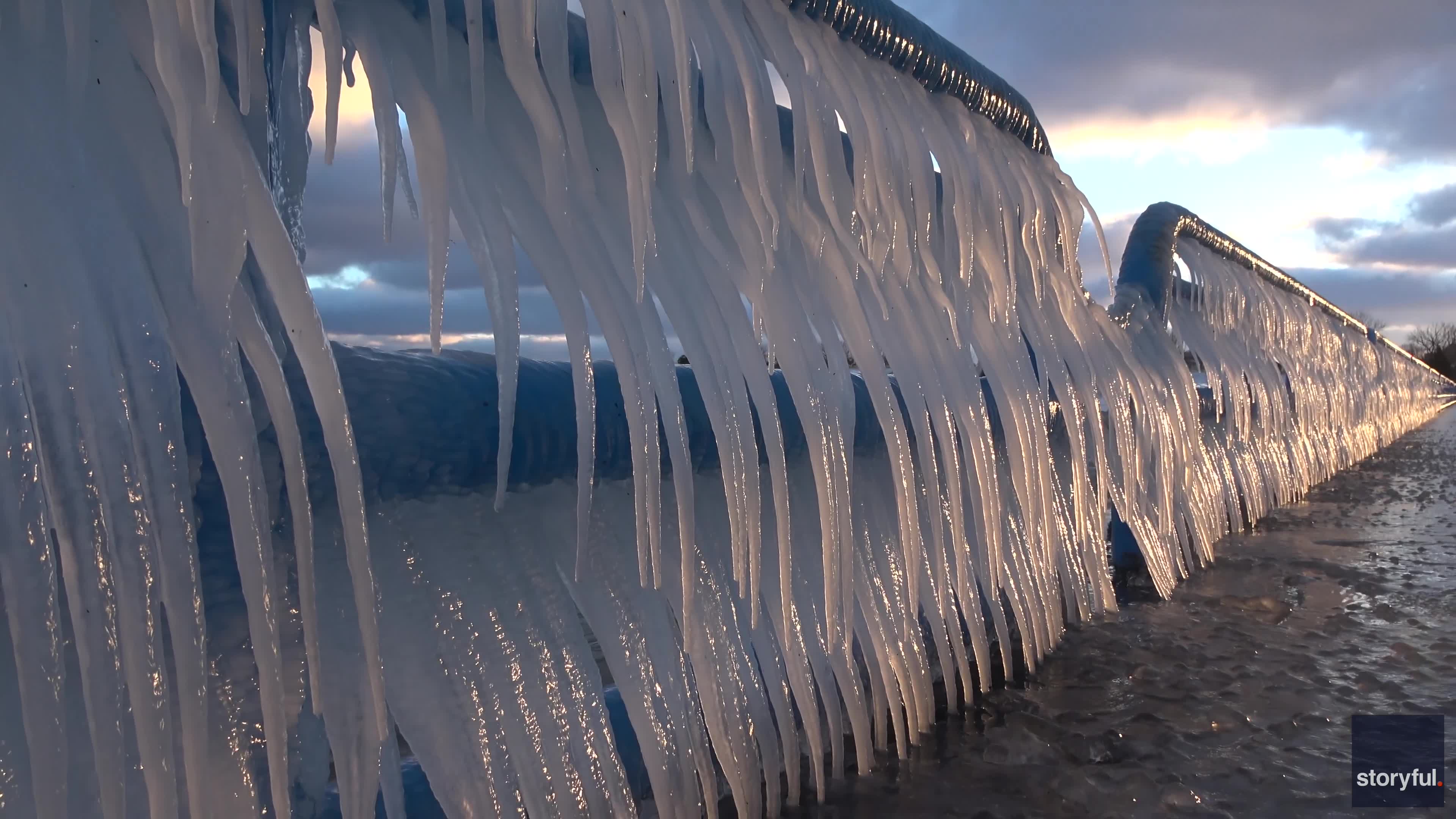

Video: Walls of icicles cover Lake Michigan pier as bitterly cold temperatures settle over Great Lakes
Check out what the frigid temps in Michigan created - icicle "claws" on a Lake Michigan pier.
Check out what the frigid temps in Michigan created - icicle "claws" on a Lake Michigan pier.


Cold, foggy start with a sunny, seasonal afternoon
Our weather pattern is on repeat today. The chilly, foggy morning will shift to mostly sunny and seasonal for the afternoon. Highs will range from upper 50 to low 60s. A Coastal Flood Advisory remains through tomorrow afternoon.
Our weather pattern is on repeat today. The chilly, foggy morning will shift to mostly sunny and seasonal for the afternoon. Highs will range from upper 50 to low 60s. A Coastal Flood Advisory remains through tomorrow afternoon.


Fog dominates the morning, sunshine rules the day!
- Persistent forecast through the next seven days with benign conditions and no precipitation expected. - Impacts from Tule Fog in the North Bay and interior East Bay valleys. - Next chance for rain towards the middle of the month. Dry weather dominates the weather patterns through the rest of the 7- day outlook, enabling a gradual warming trend across the region. Rather than a day when the temperatures shoot upwards, we will experience highs shoot up by a degree or two each day until you notice that by the middle of next week, temperatures are running 5 to 10 degrees above seasonal averages and highs in the inland valleys have reached the upper 60s to middle 70s. By the end of the 7-day forecast period, there are hints that a burst of offshore flow could come to the region, although exactly how strong that flow will be is till to be determined. Saturday will have moring fog then hazy sunshine. As log as the tule fog clears, highs will reach 59 at the Coast to 65 in the warmest locations in Morgan Hill.
- Persistent forecast through the next seven days with benign conditions and no precipitation expected. - Impacts from Tule Fog in the North Bay and interior East Bay valleys. - Next chance for rain towards the middle of the month. Dry weather dominates the weather patterns through the rest of the 7- day outlook, enabling a gradual warming trend across the region. Rather than a day when the temperatures shoot upwards, we will experience highs shoot up by a degree or two each day until you notice that by the middle of next week, temperatures are running 5 to 10 degrees above seasonal averages and highs in the inland valleys have reached the upper 60s to middle 70s. By the end of the 7-day forecast period, there are hints that a burst of offshore flow could come to the region, although exactly how strong that flow will be is till to be determined. Saturday will have moring fog then hazy sunshine. As log as the tule fog clears, highs will reach 59 at the Coast to 65 in the warmest locations in Morgan Hill.


First snow of La Niña winter blasts millions in mid-Atlantic, unleashing hazardous travel conditions
More than 16 million people are under Winter Weather Advisories in the mid-Atlantic, waking up to their first snow of the season in parts of Virginia and Maryland, which is creating slick travel conditions and delaying school openings across the region.
More than 16 million people are under Winter Weather Advisories in the mid-Atlantic, waking up to their first snow of the season in parts of Virginia and Maryland, which is creating slick travel conditions and delaying school openings across the region.


Morning fog, temps in 60s
Morning fog, temps in 60s.
Morning fog, temps in 60s.
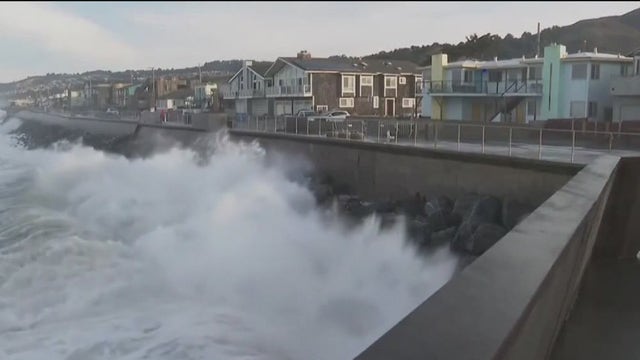

King tides flood roadways, give Bay Area preview of sea levels in 2050
The King Tides made their way into the Bay Area this week, and they will be staying around this weekend.
The King Tides made their way into the Bay Area this week, and they will be staying around this weekend.


Bundle up Friday morning
Patchy fog and cold temperatures will top our weather headlines Friday morning. The coldest parts of the Bay Area will drop into the 30s. Partly sunny skies are expected later in the day. Highs should range from the upper 50s to the low 60s. Slightly warmer temperatures are expected this weekend. Our dry stretch continues.
Patchy fog and cold temperatures will top our weather headlines Friday morning. The coldest parts of the Bay Area will drop into the 30s. Partly sunny skies are expected later in the day. Highs should range from the upper 50s to the low 60s. Slightly warmer temperatures are expected this weekend. Our dry stretch continues.


Unseasonably cool late Autumn day
Cold Weather Advisory for southern Monterey and San Benito counties midnight to 8 a.m. Friday. Benign conditions and with only a few showers over the coastal waters expected through the next seven days.
Cold Weather Advisory for southern Monterey and San Benito counties midnight to 8 a.m. Friday. Benign conditions and with only a few showers over the coastal waters expected through the next seven days.


USGS deletes 5.9 quake in Nevada from its website
The Shake Alert seismology team said they are now working to review the data, but that it appears the faulty alert might've been caused by a software error.
The Shake Alert seismology team said they are now working to review the data, but that it appears the faulty alert might've been caused by a software error.


A bit cooler
A bit cooler today with temps in the 60s.
A bit cooler today with temps in the 60s.


Nice Thursday forecast
Our dry weather stretch continues. Patchy fog resurfaces for the Thursday morning commute. Partly sunny skies are expected later in the day. Highs should range from the upper 50s to the low 60s. Look up to the skies Thursday evening to take in the supermoon! Slightly warmer temperatures are expected by the weekend. A Coastal Flood Advisory is in effect through Sunday. King Tides could cause some minor flooding around the bay shoreline.
Our dry weather stretch continues. Patchy fog resurfaces for the Thursday morning commute. Partly sunny skies are expected later in the day. Highs should range from the upper 50s to the low 60s. Look up to the skies Thursday evening to take in the supermoon! Slightly warmer temperatures are expected by the weekend. A Coastal Flood Advisory is in effect through Sunday. King Tides could cause some minor flooding around the bay shoreline.


Beach hazard, coastal flood advisory
A Beach Hazards Statement remains in effect for the coastline from Sonoma County to Monterey County through 10 p.m. tonight.
A Beach Hazards Statement remains in effect for the coastline from Sonoma County to Monterey County through 10 p.m. tonight.


The link between the super moon and extreme tides
The extreme tide cycle and December’s full super moon are linked.
The extreme tide cycle and December’s full super moon are linked.


Patch fog, breezy
Today will start off with patchy fog and breeze. Highs in the 60s.
Today will start off with patchy fog and breeze. Highs in the 60s.


Stronger winds
A cool weather system will slide to the east of the Bay Area. As this system makes its approach, wind speeds will be ramping up. Wednesday winds could approach 35 mph (strongest during the morning hours). Our dry weather stretch will remain in place through the weekend.
A cool weather system will slide to the east of the Bay Area. As this system makes its approach, wind speeds will be ramping up. Wednesday winds could approach 35 mph (strongest during the morning hours). Our dry weather stretch will remain in place through the weekend.


Weather advisories to know on Tuesday
A more substantial offshore wind push arrive late tonight and peak Wednesday morning for the North Bay, Bay Area, and Santa Cruz Mountains.
A more substantial offshore wind push arrive late tonight and peak Wednesday morning for the North Bay, Bay Area, and Santa Cruz Mountains.


Beach hazards, 60s
Dangerous surf along the coast, 60s around the Bay Area.
Dangerous surf along the coast, 60s around the Bay Area.


High tides, coastal flooding, dangerous surf across Bay Area
High tides, coastal flooding and dangerous surf conditions are expected across the Bay Area beginning Tuesday, prompting a coastal flood advisory that will remain in effect through Sunday, forecasters said.
High tides, coastal flooding and dangerous surf conditions are expected across the Bay Area beginning Tuesday, prompting a coastal flood advisory that will remain in effect through Sunday, forecasters said.


Dry stretch continues
The last day of rain around here was November 20. Our dry weather stretch should remain in place through the week, Patchy fog should resurface Tuesday morning. Mostly sunny skies are expected later in the day. Highs should range from the upper 50s to the low 60s. By Wednesday, a system will drop in from the north. Winds will be increasing. Gusts could exceed 40 mph in the hills.
The last day of rain around here was November 20. Our dry weather stretch should remain in place through the week, Patchy fog should resurface Tuesday morning. Mostly sunny skies are expected later in the day. Highs should range from the upper 50s to the low 60s. By Wednesday, a system will drop in from the north. Winds will be increasing. Gusts could exceed 40 mph in the hills.


Arctic blast ushers in freezing, potentially record cold for 235 million Americans to kick off La Niña winter
Monday is set to be the coldest day of the arctic air outbreak, where temperatures will be subzero across Montana, the Dakotas, Wyoming, Minnesota and Wisconsin.
Monday is set to be the coldest day of the arctic air outbreak, where temperatures will be subzero across Montana, the Dakotas, Wyoming, Minnesota and Wisconsin.