


Great Shakeout: Here's what to do in a California earthquake
Millions of Californians are set to "Drop, Cover, and Hold On" on Thursday as part of the annual Great California ShakeOut earthquake drill, aimed at educating the public on earthquake preparedness.
Millions of Californians are set to "Drop, Cover, and Hold On" on Thursday as part of the annual Great California ShakeOut earthquake drill, aimed at educating the public on earthquake preparedness.


Temps 60s, 70s
Today will see temps in the 60s and 70s.
Today will see temps in the 60s and 70s.


Rain clouds moving out
Our recent storm has moved out of the state. A fair weather pattern is now moving into the region. Plan on cold temperatures Thursday morning. The Bay Area will start the day off in the 40s and 50s.. Mostly sunny skies will highlight the afternoon forecast. Highs should range from the low 60s to the low 70s. The warming will continue as we head toward the weekend. By Saturday, the warmest areas could hit the low 80s.
Our recent storm has moved out of the state. A fair weather pattern is now moving into the region. Plan on cold temperatures Thursday morning. The Bay Area will start the day off in the 40s and 50s.. Mostly sunny skies will highlight the afternoon forecast. Highs should range from the low 60s to the low 70s. The warming will continue as we head toward the weekend. By Saturday, the warmest areas could hit the low 80s.


Let The Sunshine In!
Another cool day is expected across the region with lingering cloud cover. Temperatures will likely warm into the upper 50s to lower 60s across much of the region with isolated pockets nearing 70 degrees. In wake of the exiting storm, high pressure will nose in from the eastern Pacific. This will result in a gradual warming trend the next few days and weak offshore winds, mainly in the higher elevations beginning tonight. With offshore winds aloft, only expecting few clouds tonight and become clear by late evening. Temperatures Wednesday night into Thursday look to bottom out in the 40s across the interior and lower 50s around the San Francisco Bayshore and coastal areas. The highest peaks across the region very well may drop into the upper 30s. Temperatures on Thursday look to warm into the the upper 60s near the coast to lower 70s inland with mostly sunny skies by the afternoon. Again, these temperatures will be about 5 to 10 degrees below average.
Another cool day is expected across the region with lingering cloud cover. Temperatures will likely warm into the upper 50s to lower 60s across much of the region with isolated pockets nearing 70 degrees. In wake of the exiting storm, high pressure will nose in from the eastern Pacific. This will result in a gradual warming trend the next few days and weak offshore winds, mainly in the higher elevations beginning tonight. With offshore winds aloft, only expecting few clouds tonight and become clear by late evening. Temperatures Wednesday night into Thursday look to bottom out in the 40s across the interior and lower 50s around the San Francisco Bayshore and coastal areas. The highest peaks across the region very well may drop into the upper 30s. Temperatures on Thursday look to warm into the the upper 60s near the coast to lower 70s inland with mostly sunny skies by the afternoon. Again, these temperatures will be about 5 to 10 degrees below average.


Morning overcast, possible showers
The morning will be overcast, the afternoon will be mostly cloudy and have some possible showers.
The morning will be overcast, the afternoon will be mostly cloudy and have some possible showers.


Warmer, dry weather
After a couple of remarkable rainy weather days for all, we start Wednesday with cloudy skies and maybe a hint of drizzle, then turning partly cloudy and warmer! Highs will bank from the low 60s at the Coast to Mid 60s Bay, Peninsula and Inland areas! Enjoy the dry and sunny, mild days ahead!
After a couple of remarkable rainy weather days for all, we start Wednesday with cloudy skies and maybe a hint of drizzle, then turning partly cloudy and warmer! Highs will bank from the low 60s at the Coast to Mid 60s Bay, Peninsula and Inland areas! Enjoy the dry and sunny, mild days ahead!


NWS investigates possible tornado after fierce winds batter San Mateo County coast
A powerful wind event on the San Mateo County coast sent debris flying and caused major damage at a small organic farm near Año Nuevo State Park. The NWS is investigating whether the storm included a tornado.
A powerful wind event on the San Mateo County coast sent debris flying and caused major damage at a small organic farm near Año Nuevo State Park. The NWS is investigating whether the storm included a tornado.
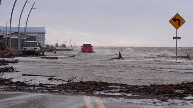

1 killed, 51 rescued as western Alaska communities devastated by floods caused by Typhoon Halong's remnants
The remnants of Typhoon Halong have brought hurricane-force winds and ravaging storm surges to western Alaska. Authorities say one person is dead and two remain missing.
The remnants of Typhoon Halong have brought hurricane-force winds and ravaging storm surges to western Alaska. Authorities say one person is dead and two remain missing.


Winter storm warning in Sierra
There's a winter storm warning in the Sierra
There's a winter storm warning in the Sierra


Will heavy rains make the Pickett Fire burn scar slide?
People in the Pickett Fire region of Napa County got phone alerts for potential flash flooding on Monday.
People in the Pickett Fire region of Napa County got phone alerts for potential flash flooding on Monday.


Scattered showers in the Tuesday forecast
The potent storm that produced heavy rain across the Bay Area on Monday will be drifting to the south. Scattered showers, along with the chance of thunderstorms, will pay us a visit Tuesday. Winter Storm Warnings are in effect for the Sierra. Areas south of Highway 50 could pick up nearly 20 inches of snow. We should have a chance to dry out later in the week.
The potent storm that produced heavy rain across the Bay Area on Monday will be drifting to the south. Scattered showers, along with the chance of thunderstorms, will pay us a visit Tuesday. Winter Storm Warnings are in effect for the Sierra. Areas south of Highway 50 could pick up nearly 20 inches of snow. We should have a chance to dry out later in the week.


Metallic balloon causes East Bay power outage; storm also causes outages
A metallic balloon was to blame for a power outage in the East Bay Monday afternoon, not the rainstorm, officials with Pacific Gas and Electric say.
A metallic balloon was to blame for a power outage in the East Bay Monday afternoon, not the rainstorm, officials with Pacific Gas and Electric say.


First storm of the season rolls into Bay Area
Portions of the North Bay saw scattered showers Monday, with the greater Bay Area getting its share later in the day and during the evening commute. The wet weather marked the first storm of the season for the region.
Portions of the North Bay saw scattered showers Monday, with the greater Bay Area getting its share later in the day and during the evening commute. The wet weather marked the first storm of the season for the region.


Bay Area weather: Flood advisories in effect as storm rolls through
IS IT RAINING NEAR YOU? Rain returned to the Bay Area today, with showers scattered in the North Bay and more rainfall expected across the wider Bay Area later in the day.
IS IT RAINING NEAR YOU? Rain returned to the Bay Area today, with showers scattered in the North Bay and more rainfall expected across the wider Bay Area later in the day.


Look for the umbrella
Big changes in the Bay Area weather pattern! A potent system will drift down the coast Monday, bringing rain, thunderstorms, and gusty winds. Rain is expected to pick up mid-morning Monday. Rainfall, possibly, heavy at times, will move over the entire Bay Area by noon, Heads up for the Sierra! A Winter Storm Warning will be in effect for the West Slopes of the Sierra. Showers and thunderstorm chances remain in the Tuesday forecast.
Big changes in the Bay Area weather pattern! A potent system will drift down the coast Monday, bringing rain, thunderstorms, and gusty winds. Rain is expected to pick up mid-morning Monday. Rainfall, possibly, heavy at times, will move over the entire Bay Area by noon, Heads up for the Sierra! A Winter Storm Warning will be in effect for the West Slopes of the Sierra. Showers and thunderstorm chances remain in the Tuesday forecast.


Sunny today, stormy tomorrow
Another sunny, dry, breezy afternoon expected today, with afternoon highs ranging from low 60s at the coast to upper 70s inland. Clouds increase tonight before wet weather arrives tomorrow.
Another sunny, dry, breezy afternoon expected today, with afternoon highs ranging from low 60s at the coast to upper 70s inland. Clouds increase tonight before wet weather arrives tomorrow.


Sunny Sunday; Messy Monday!
Weather Headline: Widespread rainfall and isolated thunderstorms Monday and Tuesday with drier conditions returning by Wednesday afternoon. For Sunday: There is about a 20%-30% chance of seeing fog in the North Bay Valleys early Sunday morning before clearing skies return. Sunday afternoon will feature mostly sunny skies and temperatures in the 60s near the coast to mid 70s across the interior. Cloud cover will increase late in the day and into Sunday night as a cold Autumn storm drops southward down the Washington/Oregon. Rainfall totals from Monday through Wednesday currently look to range from 1.50"-2.50 (isolated up to 3.00") in the Santa Lucia Range and in the Santa Cruz Mountains, with generally less than 1.50" elsewhere. Locally heavy rainfall will be possible within any stronger rain shower and/or thunderstorm. This would lead to minor/nuisance flooding concerns across much of the Bay Area and Central Coast. Remember these number could/will fluctuate. :droplet::snow_cloud: Message ktvu-weather-forecast-updates Shift + Enter to add a new line
Weather Headline: Widespread rainfall and isolated thunderstorms Monday and Tuesday with drier conditions returning by Wednesday afternoon. For Sunday: There is about a 20%-30% chance of seeing fog in the North Bay Valleys early Sunday morning before clearing skies return. Sunday afternoon will feature mostly sunny skies and temperatures in the 60s near the coast to mid 70s across the interior. Cloud cover will increase late in the day and into Sunday night as a cold Autumn storm drops southward down the Washington/Oregon. Rainfall totals from Monday through Wednesday currently look to range from 1.50"-2.50 (isolated up to 3.00") in the Santa Lucia Range and in the Santa Cruz Mountains, with generally less than 1.50" elsewhere. Locally heavy rainfall will be possible within any stronger rain shower and/or thunderstorm. This would lead to minor/nuisance flooding concerns across much of the Bay Area and Central Coast. Remember these number could/will fluctuate. :droplet::snow_cloud: Message ktvu-weather-forecast-updates Shift + Enter to add a new line


Mild, breezy weekend with a major change next week
Saturday will be joined by dry, breezy, unseasonably mild temps. Afternoon highs will range from low 60s at the coast to low 70s inland. Minor changes are expected for Sunday before rainy days arrive next week.
Saturday will be joined by dry, breezy, unseasonably mild temps. Afternoon highs will range from low 60s at the coast to low 70s inland. Minor changes are expected for Sunday before rainy days arrive next week.


Wonderful Weekend, Muddy Monday!
- Cool, dry, and mostly clear weekend - Widespread rainfall Monday through Wednesday with chances for thunderstorms Monday and Tuesday. Let's concentrate on the weekend before we talk rain for next week. It will be sunny Saturday with slightly below average high temperatures for October. Expect high 60s at the Coast and low to mid 70s around the Peninsula, Bay and Inland. It will be breezy to windy with Northwest winds increasing 20 to 30 mph, especially in the higher elevations. Sunday will be slightly warmer and breezy with increasing clouds late day into nightside. Rain develops for the Holiday on Monday.
- Cool, dry, and mostly clear weekend - Widespread rainfall Monday through Wednesday with chances for thunderstorms Monday and Tuesday. Let's concentrate on the weekend before we talk rain for next week. It will be sunny Saturday with slightly below average high temperatures for October. Expect high 60s at the Coast and low to mid 70s around the Peninsula, Bay and Inland. It will be breezy to windy with Northwest winds increasing 20 to 30 mph, especially in the higher elevations. Sunday will be slightly warmer and breezy with increasing clouds late day into nightside. Rain develops for the Holiday on Monday.


When is it going to rain? First storm system on the way to the Bay Area
Rainfall could range from one inch to an inch-and-a-half in San Francisco, to up to two inches of rain in areas such as Santa Cruz.
Rainfall could range from one inch to an inch-and-a-half in San Francisco, to up to two inches of rain in areas such as Santa Cruz.