


Line Fire: New evacuations ordered as blaze flares up
Amid a flare-up, fire officials said the fire is burning in the Bear Creek area south of the Snow Valley Resort and that smoke can be seen throughout the Inland Empire and High Desert.
Amid a flare-up, fire officials said the fire is burning in the Bear Creek area south of the Snow Valley Resort and that smoke can be seen throughout the Inland Empire and High Desert.


Line Fire in San Bernardino County burns 7,000+ acres; evacuation orders issued
The Line fire has burned over 7,100 acres, prompting evacuation orders across the area.
The Line fire has burned over 7,100 acres, prompting evacuation orders across the area.


Warm Sunday
The fog returns to the area Sunday morning. Partly to mostly sunny skies are expected during the afternoon. Highs should range from the mid 60s near the coast to the low 90s inland. Temperatures should cool a bit next week. Have a great Sunday!
The fog returns to the area Sunday morning. Partly to mostly sunny skies are expected during the afternoon. Highs should range from the mid 60s near the coast to the low 90s inland. Temperatures should cool a bit next week. Have a great Sunday!


A minor cool down is on the way for the weekend
A modest cool down is expected today. Afternoon highs will range from 60s at the coast to 70s and 80s around the bay, upper 80s to low 90s inland.
A modest cool down is expected today. Afternoon highs will range from 60s at the coast to 70s and 80s around the bay, upper 80s to low 90s inland.


Cooling begins
The Heat Advisory is now history. The cooling trend begins this weekend. The clouds will resurface near the coast and bay Saturday morning. Mostly sunny skies will highlight the afternoon forecast. Patchy fog could linger near the shoreline. Highs should range from the mid 60s near the coast to the low 90s inland. Cooler temperatures are expected next week. Have a great weekend! -Mark
The Heat Advisory is now history. The cooling trend begins this weekend. The clouds will resurface near the coast and bay Saturday morning. Mostly sunny skies will highlight the afternoon forecast. Patchy fog could linger near the shoreline. Highs should range from the mid 60s near the coast to the low 90s inland. Cooler temperatures are expected next week. Have a great weekend! -Mark


2 toddlers found dead in Oklahoma hot car tragedy, police say
Two toddlers were found lifeless inside a parked car in Oklahoma as temperatures soared to 90 degrees, according to authorities.
Two toddlers were found lifeless inside a parked car in Oklahoma as temperatures soared to 90 degrees, according to authorities.


California employers must protect workers as triple-digit heat arrives
The state of California this week reminded all employers that it's their job to protect their employees when the mercury rises into the triple digits, which is forecast for Friday.
The state of California this week reminded all employers that it's their job to protect their employees when the mercury rises into the triple digits, which is forecast for Friday.


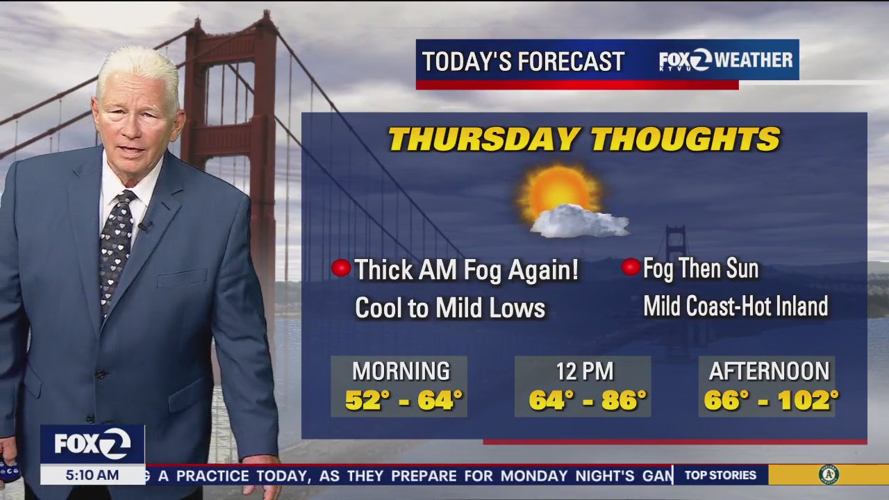
Fog then sun
Today will start of foggy and then become hot inland.
Today will start of foggy and then become hot inland.


Heat advisory extended
Heat Advisory extended until Friday evening. Temperatures will make it back into the upper 90s inland on Friday.
Heat Advisory extended until Friday evening. Temperatures will make it back into the upper 90s inland on Friday.


Feeling the heat as Earth breaks yet another record for hottest summer
Summer 2024 sweltered to Earth's hottest on record, making it even more likely that this year will end up as the warmest humanity has measured, European climate service Copernicus reported Friday.
Summer 2024 sweltered to Earth's hottest on record, making it even more likely that this year will end up as the warmest humanity has measured, European climate service Copernicus reported Friday.


Warm to hot Friday
The warm to hot pattern sticks around for one more day. Dense fog could be a factor near the coast and bay during the Friday morning commute. Highs should range from the mid 60s near the coast to 100 degrees well inland. Our next cooling trend moves in this weekend. Have a great Friday! -Mark
The warm to hot pattern sticks around for one more day. Dense fog could be a factor near the coast and bay during the Friday morning commute. Highs should range from the mid 60s near the coast to 100 degrees well inland. Our next cooling trend moves in this weekend. Have a great Friday! -Mark


Warm to hot stretch continues
We are still tracking some coastal fog Thursday afternoon. Inland neighborhoods are dealing with the heat again. Highs today should range from the mid 60s near the coast to 102 well inland. The Heat Advisory has been extended through Friday evening. The weekend forecast features a cooling trend. Enjoy the rest of your Thursday! -Mark
We are still tracking some coastal fog Thursday afternoon. Inland neighborhoods are dealing with the heat again. Highs today should range from the mid 60s near the coast to 102 well inland. The Heat Advisory has been extended through Friday evening. The weekend forecast features a cooling trend. Enjoy the rest of your Thursday! -Mark

Still hot
Temps will range from the 60s at the coast to 102 inland.
Temps will range from the 60s at the coast to 102 inland.
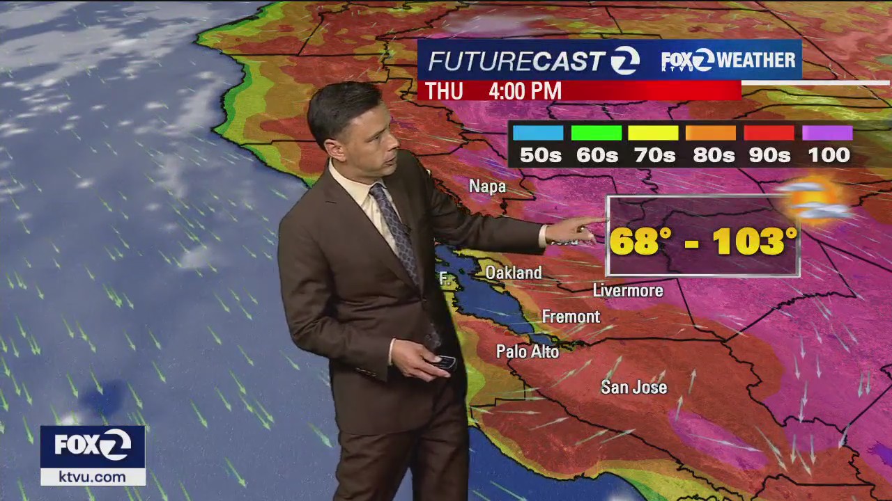

Warm to hot forecast
The warm to hot weather pattern continues. Fog returns to the coast and bay Thursday morning. While patchy fog will cap temperatures near the coast (60s), inland areas will approach triple digit territory. The Friday forecast features slightly cooler temperatures. A cooling trend moves in this weekend. Have a great Thursday! -Mark
The warm to hot weather pattern continues. Fog returns to the coast and bay Thursday morning. While patchy fog will cap temperatures near the coast (60s), inland areas will approach triple digit territory. The Friday forecast features slightly cooler temperatures. A cooling trend moves in this weekend. Have a great Thursday! -Mark


50 wildfire sensors installed in San Mateo County
Firefighters on the Peninsula and in the South Bay have a new tool to combat wildfires. 50 new wildfire N5 sensors have been installed across San Mateo County.
Firefighters on the Peninsula and in the South Bay have a new tool to combat wildfires. 50 new wildfire N5 sensors have been installed across San Mateo County.
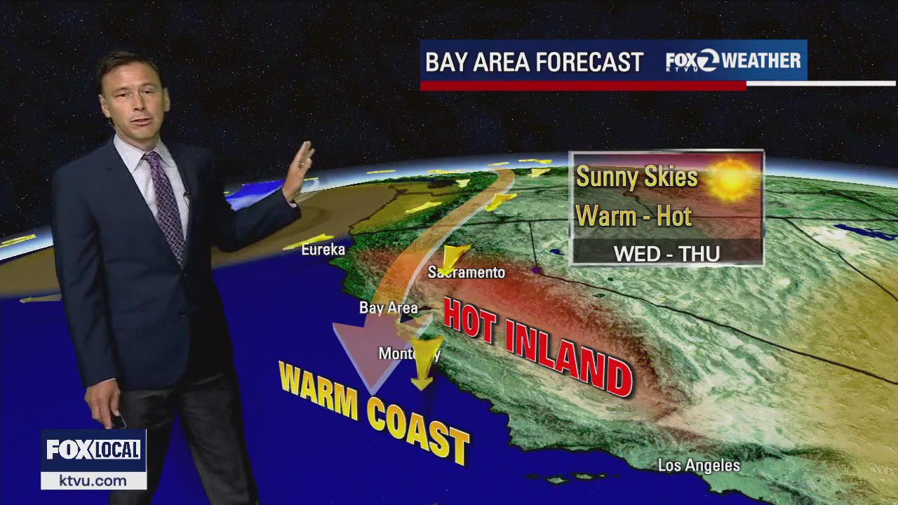

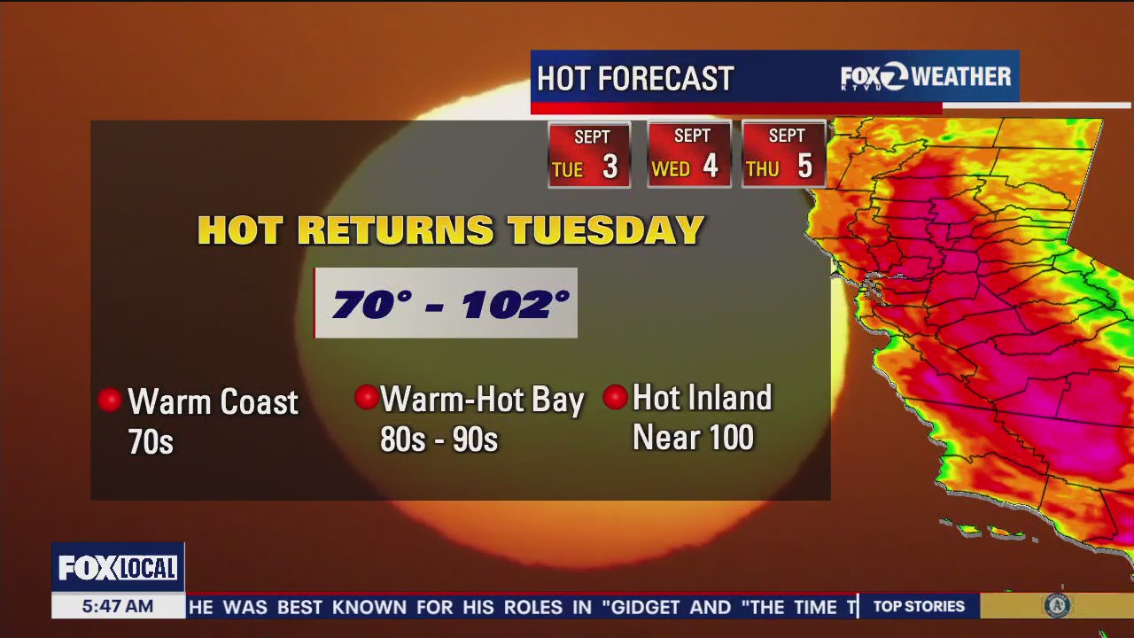
September heat
The warm to hot pattern will highlight the Wednesday forecast. Highs should range from the mid 70s near the coast to 100 plus well inland. The hot stretch lasts through Thursday. We are expecting cooler temperatures this weekend.
The warm to hot pattern will highlight the Wednesday forecast. Highs should range from the mid 70s near the coast to 100 plus well inland. The hot stretch lasts through Thursday. We are expecting cooler temperatures this weekend.


Bear Fire near Tahoe sends hundreds to flee from their homes
A wildfire in Tahoe National Forest in Sierra County has exploded to almost 1,600 acres as of Tuesday afternoon and prompted hundreds of evacuations in the area.
A wildfire in Tahoe National Forest in Sierra County has exploded to almost 1,600 acres as of Tuesday afternoon and prompted hundreds of evacuations in the area.


Californians to face steep fines for violating water orders under new legislation
The new legislation, which is now awaiting Gov. Gavin Newsom’s signature, would double daily fines for water rights holders who commit minor violations. Those violating curtailment orders could face fines of up to $10,000 per day — a 20-fold increase — plus $2,500 for every acre-foot of water taken.
The new legislation, which is now awaiting Gov. Gavin Newsom’s signature, would double daily fines for water rights holders who commit minor violations. Those violating curtailment orders could face fines of up to $10,000 per day — a 20-fold increase — plus $2,500 for every acre-foot of water taken.

Heating up
It's heating up across the Bay. Temps could reach the 90s and low 100s inland.
It's heating up across the Bay. Temps could reach the 90s and low 100s inland.


Bear Fire sparks in Tahoe National Forest, evacuations underway in Sierra County
A wildfire that sparked in Tahoe National Forest on Monday afternoon has grown to more than 1,000 acres and is prompting evacuations in the area, according to Cal Fire.
A wildfire that sparked in Tahoe National Forest on Monday afternoon has grown to more than 1,000 acres and is prompting evacuations in the area, according to Cal Fire.