

California fires map: Los Angeles evacuation orders, warnings
LOS ANGELES - Updated interactive map of evacuation warnings and orders
As multiple wildfires roar throughout Southern California, local municipalities are working to keep evacuation zones up to date for residents who may be wondering if they should stay or go.
Fire crews are currently fighting several wildfires in Los Angeles County, which include:
Here's the latest on fire boundaries and evacuation orders and warnings.
Palisades Fire map
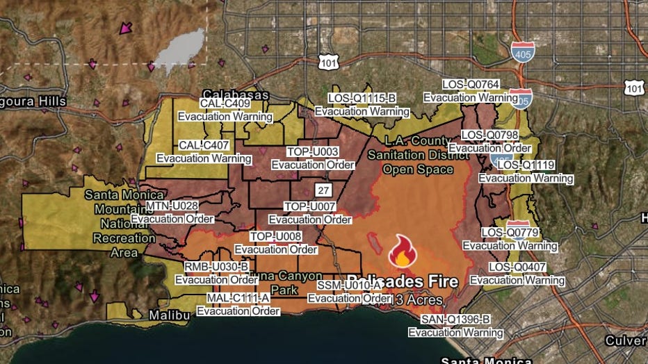
Last updated on Jan. 14, 2025, at 4 a.m. PT
Acres burned: 23,713 acres
The Palisades Fire was 17% contained as it burned for an eighth day on Tuesday, according to Cal Fire.
More than 3,000 fire personnel were battling the blaze. At least eight people were killed and more than 5,000 structures have been destroyed.
Evacuation orders and warnings
A flare-up on the northeastern edge of the fire broke out Friday night, forcing evacuations in the Mandeville Canyon and Encino areas.
The following areas remain under evacuation orders as of Sunday evening:
- South: Pacific Coast Highway
- East: 405 Freeway
- West: Mandeville Canyon
The following areas remain under evacuation warnings:
- South: Sunset Blvd
- North: Mullholland Dr
- East: Bellagio Rd/Roscomare Rd
- West: 405 Freeway
- South: Mulholland Dr / Sepulveda Blvd
- East: 405 Freeway
- North: Ventura Blvd
- West: Louise Ave
Two more evacuation centers were also opened at the Lanark Recreation Center at 21816 Lanark St, Canoga Park, CA 91304, and at the Van Nuys Recreation Center at 14201 Huston St, Sherman Oaks, 91423.
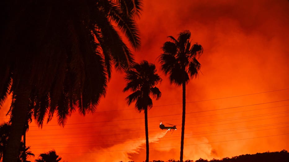
Firefighting planes and helicopters drop water over flames in Mandeville Canyon during 'Palisades Fire' in Los Angeles, California, United States on January 10, 2025. (Photo by Tayfun Coskun/Anadolu via Getty Images)
There's a 6 p.m. - 6 a.m. curfew in place for all areas under mandatory evacuation orders and evacuation warnings in the Palisades Fire. Around 7 p.m. Friday, a new flare-up on the northeastern edge of the fire broke out, forcing evacuations in the Mandeville Canyon and Encino areas. The flames have also led officials to consider closing portions of the 405 Freeway near Bel-Air and Westwood.
For more detailed information about evacuation warnings and orders for the Palisades Fire, click here.
Eaton Fire map

Last updated on Jan. 14, 2025, at 4 a.m. PT
Acres burned: 14,117
The Eaton fire was 35% contained as of Tuesday morning. Officials said more than 7,000 structures may be damaged or destroyed.
The fire was first reported Jan. 7 near Altadena and Midwick drives just after 6:15 p.m. in Altadena. By noon Thursday, the fire had reached the summit of Mt. Wilson, but officials said Friday that no structures on Mt. Wilson have been damaged.
Sixteen people have died as a result of the Eaton blaze, officials said Sunday. The total death toll from both fires is 24, according to the County Medical Examiner's Office.
There are 12 missing persons reports filed with the LA County Sheriff's Office in the Eaton fire, but Sheriff Robert Luna said it appears there are more missing persons reports that just came in. Updated numbers will be released later Sunday. No juveniles have been reported missing, he said.
Evacuation orders and warnings
Evacuation orders and warnings are still in place for the Eaton fire, but multiple evacuation orders were downgraded.
"Driving around, some [areas] look like war zones," Luna said. "There are downed power poles, electric wires. There are still some smoldering fires. It is not safe."
On Saturday, officials lifted evacuation orders in Bradbury, Bradbury Estates, Duarte, La Cañada Flintridge, including all residences:
- From Angeles Crest Highway east to Oakwood Avenue
- North of Angeles Crest Highway at the curve west to Haskel Street
- North of Foothill Boulevard to Knight Way and the intersection of Gould Canyon Trail at Crown Avenue
- East to Varo Road
Evacuation orders were downgraded to warnings in La Cañada Flintridge:
- North of Knight Way/ Gould Canyon Trail and east of Oakwood Avenue/ Angeles Crest Highway at the curve to Gould Mesa Road and Starlight Crest Drive
- The NASA Jet Propulsion Laboratory
There's a 6 p.m. - 6 a.m. curfew in place for all areas under mandatory evacuation orders and evacuation warnings because of the Eaton Fire, within the Altadena area. There is no curfew in evacuation zones located in the city of Pasadena.
For more detailed information about evacuation warnings and orders for the Eaton Fire, click here.
Hurst Fire map
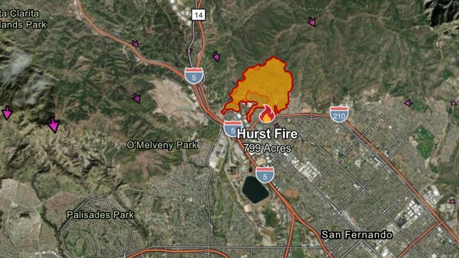
Last updated on Jan. 14, 2025, at 4 a.m. PT
Acres burned: 799
The Hurst Fire was first reported at about 10:30 p.m. on Tuesday in the 5900 block of Yarnell Street.
It was 97% contained as of Tuesday morning.
Evacuation orders and warnings
All mandatory evacuation orders and warnings have been lifted for the Hurst Fire.
Auto Fire map
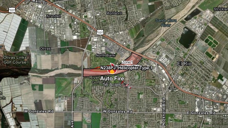
Last updated on Jan. 14, 2025, at 4 a.m. PT
Acres burned: 56
The Auto Fire broke out around 7:15 p.m. on Jan. 13 in Ventura County. The fire was spotted along the Santa Clara River near Ventura Boulevard and Auto Center Drive in Ventura, California.
It was 0% contained as of Tuesday morning.
Evacuation orders and warnings
- Areas near the Santa Clara River along Ventura Road
- West to Victoria Avenue
- East to 101 Freeway in Ventura County along Auto Center Drive
The Source: Information for this article was gathered from the CalFire website, FOX 11 Los Angeles and The Associated Press. This story was reported from Los Angeles.