

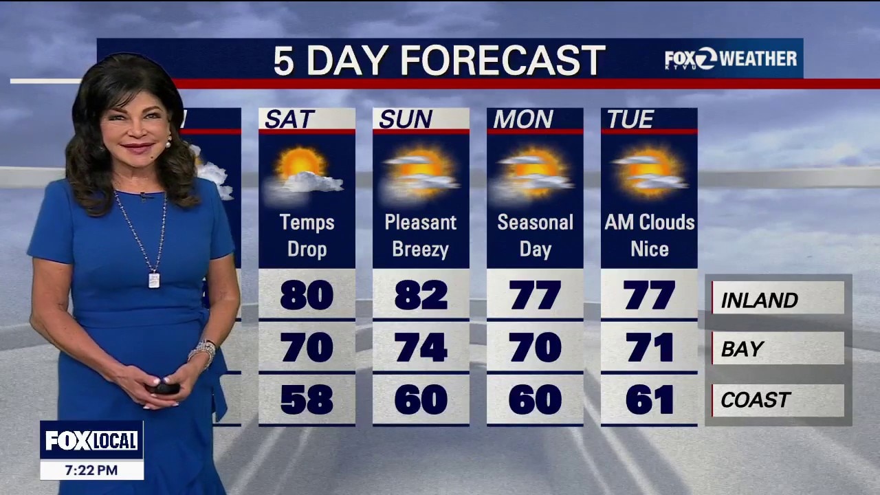
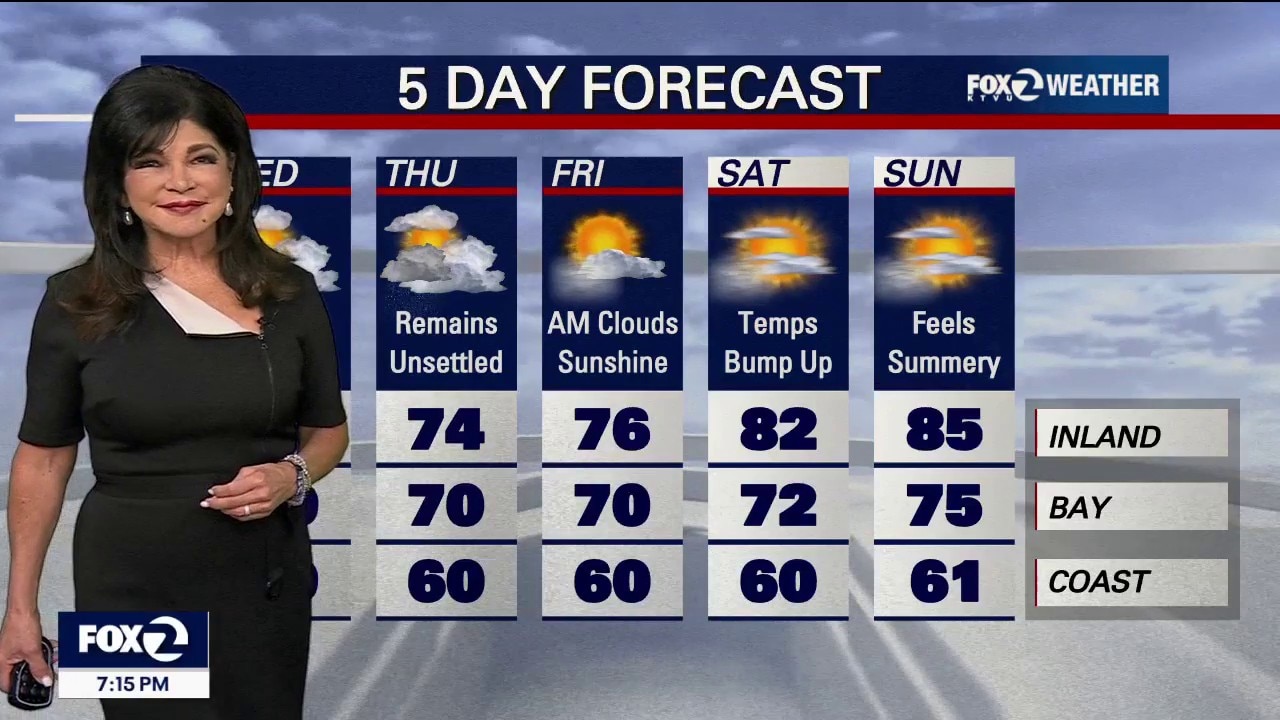
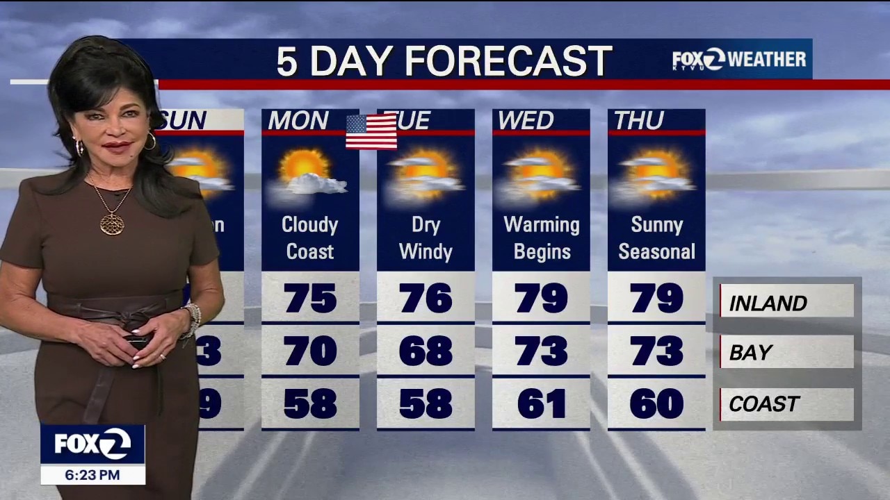
The heat is fading and temperatures are dropping this afternoon
The Bay Area is transitioning from summer like heat to typical spring like temps. for your Bay Area Saturday. Afternoon highs warm slightly on Sunday, followed by a possibility of light rain or drizzle Monday through Tuesday.
The Bay Area is transitioning from summer like heat to typical spring like temps. for your Bay Area Saturday. Afternoon highs warm slightly on Sunday, followed by a possibility of light rain or drizzle Monday through Tuesday.
Beach Hazard coast side, hot inland today
Under mostly sunny skies, temps. will soar into the 90s inland today, 70s - 80s around the bay, 60s-70s along the coast with a Beach Hazard Alert until tomorrow morning for an increased risk of RIP Currents and Sneaker Waves. A notable drop in temps. on the way for the weekend and beyond.
Under mostly sunny skies, temps. will soar into the 90s inland today, 70s - 80s around the bay, 60s-70s along the coast with a Beach Hazard Alert until tomorrow morning for an increased risk of RIP Currents and Sneaker Waves. A notable drop in temps. on the way for the weekend and beyond.
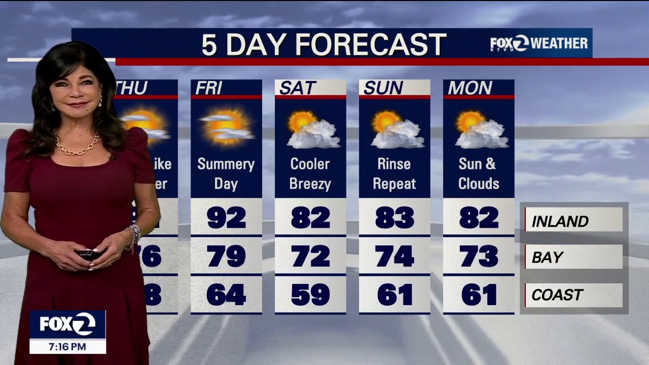
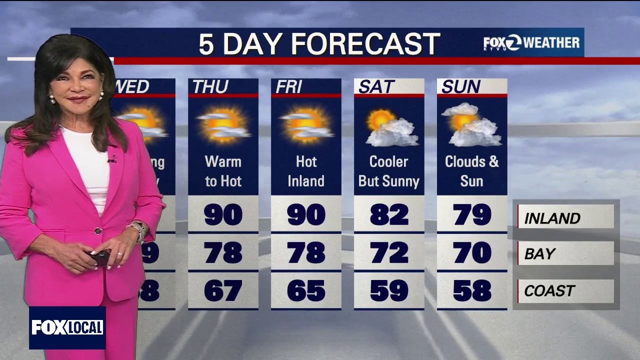
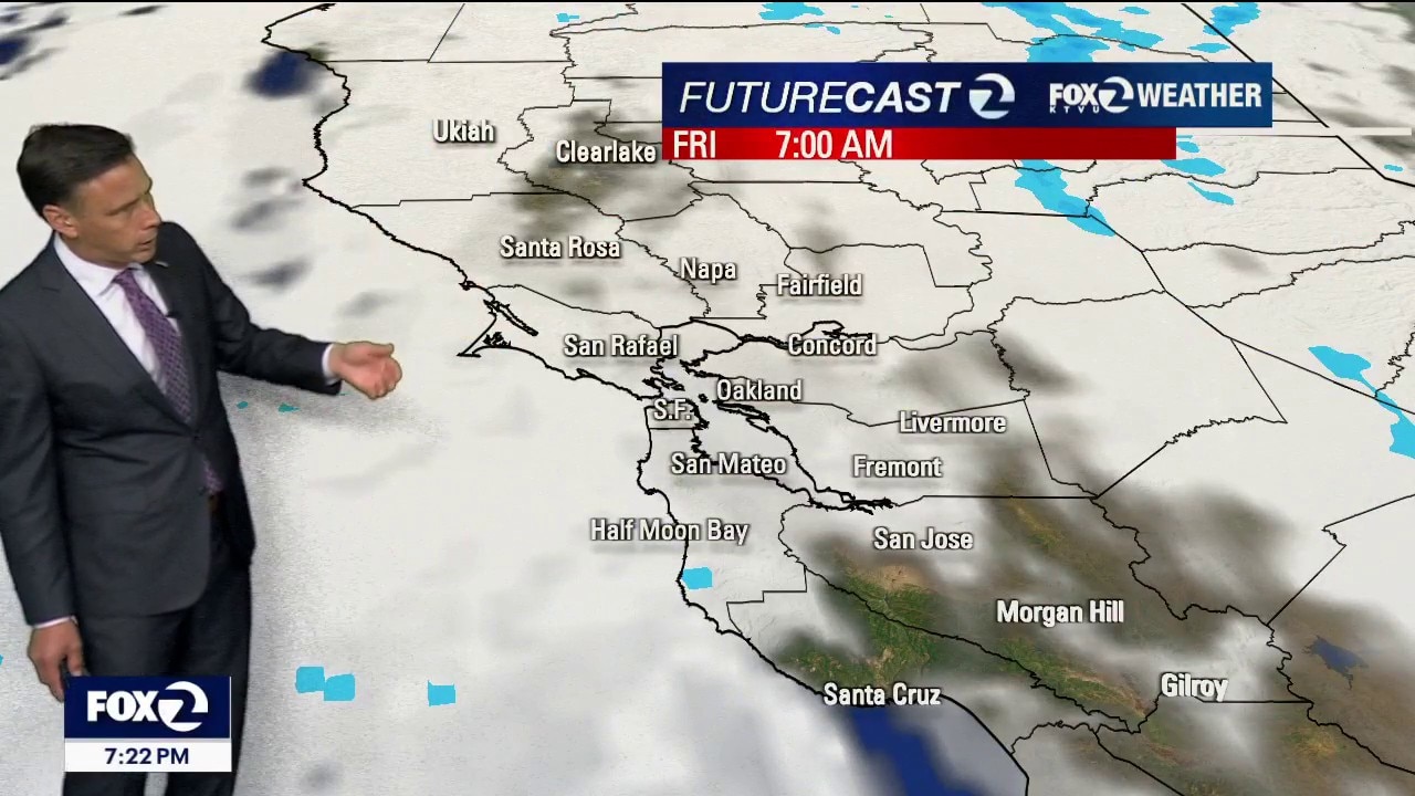
Friday Sizzle to Monday Drizzle
The Forecast: Day-by-Day Tonight: Skies remain mostly clear inland. The coastal fog machine will stay confined mostly to the Monterey Bay region and parts of the SF Peninsula by Friday morning. Friday (The Peak Heat): Friday is the hot one. Inland valleys will easily soar back into the 80s and 90s. Only the furthest inlkand spots will hit a "Moderate Heat Risk," while beaches stay in the 60s thanks to a refreshing afternoon sea breeze. Beach Hazard Statement in effect Friday through Saturday 9 AM for sneaker waves and rip currents. The Weekend Shift: The cold front hits Saturday. Temperatures will plunge 5 to 10 degrees below seasonal averages for both Saturday and Sunday (but still a couple degrees above average inland!). Expect widespread morning fog, potential coastal drizzle, and gusty winds through our mountain passes. Early Next Week: The chill deepens Monday and Tuesday. A slight chance of actual light rain showers for the Bay Area northward.
The Forecast: Day-by-Day Tonight: Skies remain mostly clear inland. The coastal fog machine will stay confined mostly to the Monterey Bay region and parts of the SF Peninsula by Friday morning. Friday (The Peak Heat): Friday is the hot one. Inland valleys will easily soar back into the 80s and 90s. Only the furthest inlkand spots will hit a "Moderate Heat Risk," while beaches stay in the 60s thanks to a refreshing afternoon sea breeze. Beach Hazard Statement in effect Friday through Saturday 9 AM for sneaker waves and rip currents. The Weekend Shift: The cold front hits Saturday. Temperatures will plunge 5 to 10 degrees below seasonal averages for both Saturday and Sunday (but still a couple degrees above average inland!). Expect widespread morning fog, potential coastal drizzle, and gusty winds through our mountain passes. Early Next Week: The chill deepens Monday and Tuesday. A slight chance of actual light rain showers for the Bay Area northward.
From June Gloom To June Jump!
We are on a weather roller coaster. After a massive temperature jump today, Thursday and Friday will bring the peak of this week's early-summer heat under clear, sunny skies. However, a cold storm system from the Gulf of Alaska is timing its arrival perfectly to knock temperatures down significantly just in time for the weekend. Short-Term Forecast (Tonight through Friday) Tonight: The coastal fog machine is starting back up, but it will remain shallow. Expect patchy low clouds to hug the San Francisco Peninsula and the Monterey Bay region by Thursday morning. Thursday: Morning clouds clear quickly for a stellar, sun-drenched afternoon. Highs will range from the 60s on the coast, the 70s and 80s around the Bay and a hot upper 80s to mid-90s in the far interior valleys. Friday: A true "rinse and repeat" day. Temperatures will hold steady as the warmest day of the week, offering perfect patio weather across the inland neighborhoods. Long-Term Forecast (The Weekend through Next Tuesday) The Saturday Shift: A weak cold front pushes south through the area, bringing a sudden, 10-degree drop in temperatures across the board. (But, still very nice weather!) The Weekend Air Conditioning: Strong, gusty onshore winds will kick up on Saturday and Sunday afternoon. The marine layer will deepen dramatically, bringing back widespread gray mornings and the threat of damp coastal drizzle. Early Next Week: The cooling trend deepens into Monday and Tuesday, keeping temperatures well below normal for June.
We are on a weather roller coaster. After a massive temperature jump today, Thursday and Friday will bring the peak of this week's early-summer heat under clear, sunny skies. However, a cold storm system from the Gulf of Alaska is timing its arrival perfectly to knock temperatures down significantly just in time for the weekend. Short-Term Forecast (Tonight through Friday) Tonight: The coastal fog machine is starting back up, but it will remain shallow. Expect patchy low clouds to hug the San Francisco Peninsula and the Monterey Bay region by Thursday morning. Thursday: Morning clouds clear quickly for a stellar, sun-drenched afternoon. Highs will range from the 60s on the coast, the 70s and 80s around the Bay and a hot upper 80s to mid-90s in the far interior valleys. Friday: A true "rinse and repeat" day. Temperatures will hold steady as the warmest day of the week, offering perfect patio weather across the inland neighborhoods. Long-Term Forecast (The Weekend through Next Tuesday) The Saturday Shift: A weak cold front pushes south through the area, bringing a sudden, 10-degree drop in temperatures across the board. (But, still very nice weather!) The Weekend Air Conditioning: Strong, gusty onshore winds will kick up on Saturday and Sunday afternoon. The marine layer will deepen dramatically, bringing back widespread gray mornings and the threat of damp coastal drizzle. Early Next Week: The cooling trend deepens into Monday and Tuesday, keeping temperatures well below normal for June.
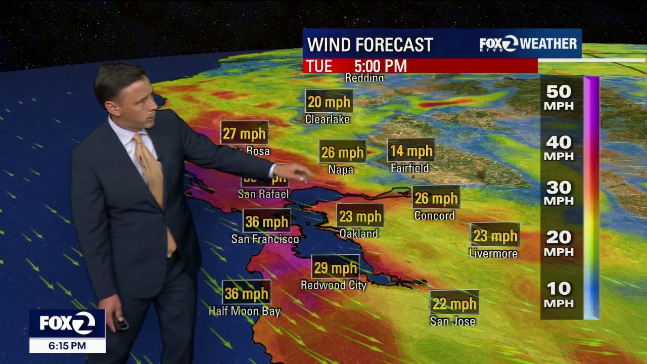
Winds Whipping Up Wednesday
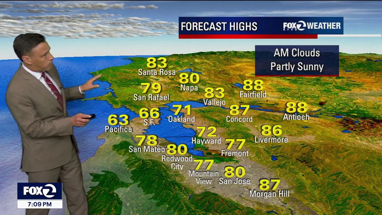
Coastal fog is expected to clear by Wednesday morning due to strengthening winds, allowing temperatures to rise slightly into the 70s-90s before a significant cool down arrives this weekend. A low-pressure system moving in on Saturday will bring colder temperatures, increased cloud cover and potential drizzle into next week. Wednesday will bring a mix of clearing skies, slightly warmer afternoon temperatures and very strong, gusty winds. Wednesday: Sky & Fog: Early morning clouds and thick fog will break up much faster than Tuesday. Expect sunshine across most areas by late morning. Temperatures: A few degrees warmer than Tuesday. Beaches & Bay Shores: Chilly 60s to mid-70s. Inland Valleys: Hot 80s to mid-90s. Wind Forecast: Winds will pick up significantly by Wednesday afternoon and evening.
Coastal fog is expected to clear by Wednesday morning due to strengthening winds, allowing temperatures to rise slightly into the 70s-90s before a significant cool down arrives this weekend. A low-pressure system moving in on Saturday will bring colder temperatures, increased cloud cover and potential drizzle into next week. Wednesday will bring a mix of clearing skies, slightly warmer afternoon temperatures and very strong, gusty winds. Wednesday: Sky & Fog: Early morning clouds and thick fog will break up much faster than Tuesday. Expect sunshine across most areas by late morning. Temperatures: A few degrees warmer than Tuesday. Beaches & Bay Shores: Chilly 60s to mid-70s. Inland Valleys: Hot 80s to mid-90s. Wind Forecast: Winds will pick up significantly by Wednesday afternoon and evening.
Mother Nature easing off the heat
Happy Tuesday everyone! The fog is back, the onshore breeze is up and afternoon highs are taking a subtle drop. For the second half of the day, a mix of low and high level clouds will join us with temps. ranging from 60s at the coast to upper 80s inland. Minor fluctuations are expected until a bigger cool down on the weekend.
Happy Tuesday everyone! The fog is back, the onshore breeze is up and afternoon highs are taking a subtle drop. For the second half of the day, a mix of low and high level clouds will join us with temps. ranging from 60s at the coast to upper 80s inland. Minor fluctuations are expected until a bigger cool down on the weekend.
Cooler Tuesday forecast
Welcome to June! The marine layer will deepen Tuesday morning. Most areas will cool off a bit. Low clouds will blanket the coast and bay during the morning hours. The clouds will gradually clear back to near the shoreline later in the day. Highs should range from the low 60s for the beaches to the upper 80s inland.
Welcome to June! The marine layer will deepen Tuesday morning. Most areas will cool off a bit. Low clouds will blanket the coast and bay during the morning hours. The clouds will gradually clear back to near the shoreline later in the day. Highs should range from the low 60s for the beaches to the upper 80s inland.
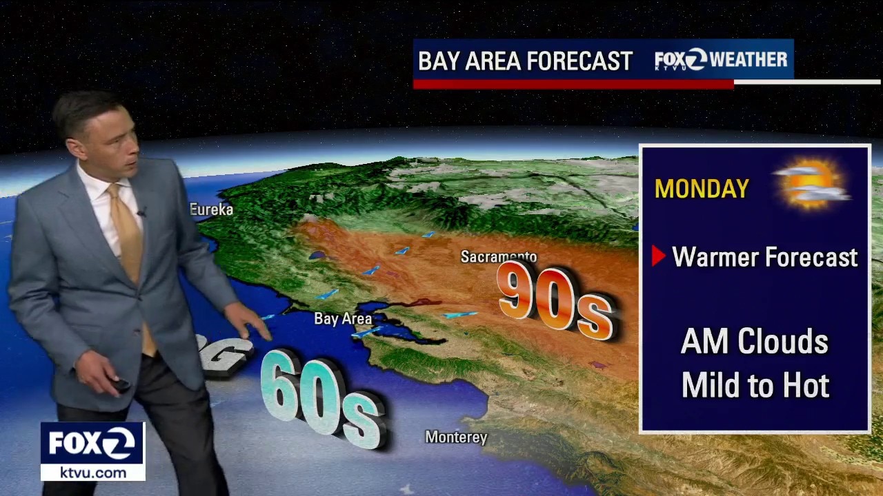
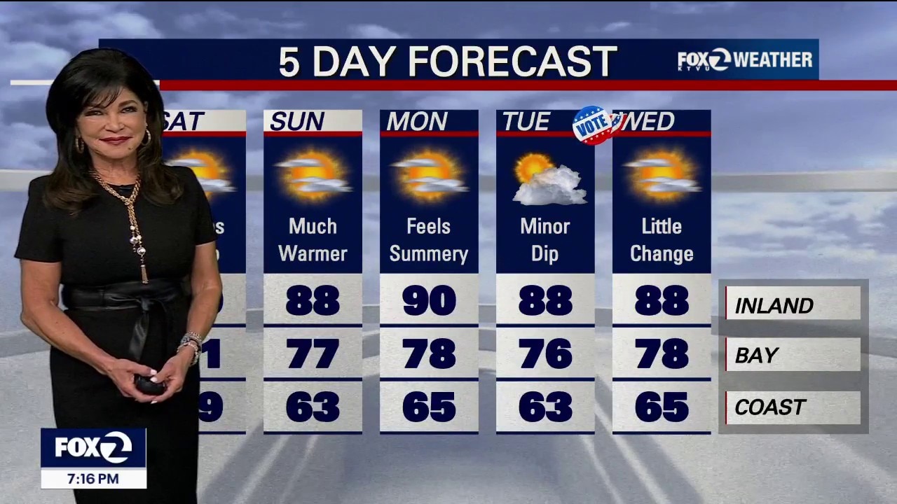
Hottest day of the week is upon us
Happy Monday Everyone. Mostly sunny skies will reign over the Bay Area today with afternoon highs ranging from low 60s at the shore to low 90s inland. A Beach Hazard Alert for our coast continues until Tuesday morning. Temperatures take a dip tomorrow. Additional cooling is expected for the weekend.
Happy Monday Everyone. Mostly sunny skies will reign over the Bay Area today with afternoon highs ranging from low 60s at the shore to low 90s inland. A Beach Hazard Alert for our coast continues until Tuesday morning. Temperatures take a dip tomorrow. Additional cooling is expected for the weekend.
Warming continues
The Bay Area warming trend continues. Patchy fog will resurface near the coast Monday morning. Mostly sunny skies and warmer temperatures will highlight the afternoon forecast. Highs should range from the mid 60s near the coast to the low 90s inland.
The Bay Area warming trend continues. Patchy fog will resurface near the coast Monday morning. Mostly sunny skies and warmer temperatures will highlight the afternoon forecast. Highs should range from the mid 60s near the coast to the low 90s inland.
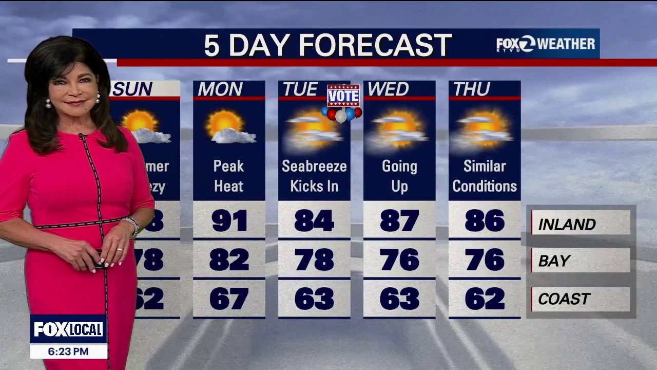
Sunday Sunshine: Inland Valleys Climb into the 80s for a Beautiful Weekend Finish
The Big Picture Our seasonal warmup is right on track. The cool, May gray weather is clearing out today, paving the way for a bright, very warm Sunday and an even hotter Monday before a cooling trend returns late next week. The Forecast: Day-by-Day Tonight: Skies will stay mostly clear for most airports, but coastal fog will return to Half Moon Bay, Monterey, and Salinas. Sunday: High pressure builds in, pushing temperatures higher under sunny skies. The coast will hit the 60s to near 70, while the interior jumps into the mid-70s to mid-80s. Monday (The Warmest Day): The heat peaks at 5 to 10 degrees above average. If the morning fog stays out at sea, even the coastal beaches will enjoy a very warm afternoon. Highs from 67 Beaches to 91 Inland. Tuesday (VOTE!) & Midweek: Temperatures bounce around a bit Wednesday and Thursday depending on how far inland the morning fog pushes. Next Weekend: A new weather system takes aim at the West Coast. While it will pull temperatures well below average, any actual rain looks like it will stay far to our north.
The Big Picture Our seasonal warmup is right on track. The cool, May gray weather is clearing out today, paving the way for a bright, very warm Sunday and an even hotter Monday before a cooling trend returns late next week. The Forecast: Day-by-Day Tonight: Skies will stay mostly clear for most airports, but coastal fog will return to Half Moon Bay, Monterey, and Salinas. Sunday: High pressure builds in, pushing temperatures higher under sunny skies. The coast will hit the 60s to near 70, while the interior jumps into the mid-70s to mid-80s. Monday (The Warmest Day): The heat peaks at 5 to 10 degrees above average. If the morning fog stays out at sea, even the coastal beaches will enjoy a very warm afternoon. Highs from 67 Beaches to 91 Inland. Tuesday (VOTE!) & Midweek: Temperatures bounce around a bit Wednesday and Thursday depending on how far inland the morning fog pushes. Next Weekend: A new weather system takes aim at the West Coast. While it will pull temperatures well below average, any actual rain looks like it will stay far to our north.
A warming trend is underway
The low clouds and patchy fog will be clearing back to the coast with mostly sunny skies for the afternoon today. A dry, warmer afternoon is expected today with temperatures ranging from low 60s at the coast to low 80s far inland. Additional warming is on the way for your Bay Area Sunday.
The low clouds and patchy fog will be clearing back to the coast with mostly sunny skies for the afternoon today. A dry, warmer afternoon is expected today with temperatures ranging from low 60s at the coast to low 80s far inland. Additional warming is on the way for your Bay Area Sunday.
May Gray, then sun and warmer weather
The Big Picture The unseasonably cold storm has officially packed its bags and moved into Nevada. High pressure from the Pacific is building in its place, triggering a well-deserved warming and drying trend that will bring normal spring temperatures back to the region by Sunday and through most of next week. The Forecast: Day-by-Day Tonight: A compressed marine layer will bring a solid blanket of low clouds inland overnight. Saturday Morning Fog & Drizzle: Watch out for thick fog if you are driving around Santa Rosa, Petaluma, or Novato early tomorrow morning, along with spotty coastal drizzle around the Monterey Peninsula. It should all clear out by mid-morning. Saturday Afternoon: The warming trend gains traction under a mix of sun and clouds. Expect highs in the upper 50s on the immediate coast, low-to-mid 60s around the Bay and pleasant 70s inland. Sunday Through Midweek: Temperatures will jump back to normal or slightly above normal. While the inland valleys warm up nicely, a returning marine layer on Monday and Tuesday will keep the beaches and coastal towns on the cooler side. Late Next Week: Don't pack away the jackets just yet. Long-range models show another cool weather system taking aim at the West Coast by next weekend. Marine Impact Boater Warning: High pressure to our north is cranking the wind machine back up over the ocean. Widespread hazardous marine conditions begin tonight. Expect strong northerly breezes with gale-force gusts ripping north of the Golden Gate and down the Big Sur Coast all weekend long. Have a great weekend!
The Big Picture The unseasonably cold storm has officially packed its bags and moved into Nevada. High pressure from the Pacific is building in its place, triggering a well-deserved warming and drying trend that will bring normal spring temperatures back to the region by Sunday and through most of next week. The Forecast: Day-by-Day Tonight: A compressed marine layer will bring a solid blanket of low clouds inland overnight. Saturday Morning Fog & Drizzle: Watch out for thick fog if you are driving around Santa Rosa, Petaluma, or Novato early tomorrow morning, along with spotty coastal drizzle around the Monterey Peninsula. It should all clear out by mid-morning. Saturday Afternoon: The warming trend gains traction under a mix of sun and clouds. Expect highs in the upper 50s on the immediate coast, low-to-mid 60s around the Bay and pleasant 70s inland. Sunday Through Midweek: Temperatures will jump back to normal or slightly above normal. While the inland valleys warm up nicely, a returning marine layer on Monday and Tuesday will keep the beaches and coastal towns on the cooler side. Late Next Week: Don't pack away the jackets just yet. Long-range models show another cool weather system taking aim at the West Coast by next weekend. Marine Impact Boater Warning: High pressure to our north is cranking the wind machine back up over the ocean. Widespread hazardous marine conditions begin tonight. Expect strong northerly breezes with gale-force gusts ripping north of the Golden Gate and down the Big Sur Coast all weekend long. Have a great weekend!
Friday clouds
The unsettled weather pattern will soon be coming to an end. Friday starts off with a big serving of clouds. Partly to mostly cloudy skies are expected later in the day. Highs should range from the upper 50s to the low 70s. The weekend forecast features more sunshine and warmer temperatures.
The unsettled weather pattern will soon be coming to an end. Friday starts off with a big serving of clouds. Partly to mostly cloudy skies are expected later in the day. Highs should range from the upper 50s to the low 70s. The weekend forecast features more sunshine and warmer temperatures.
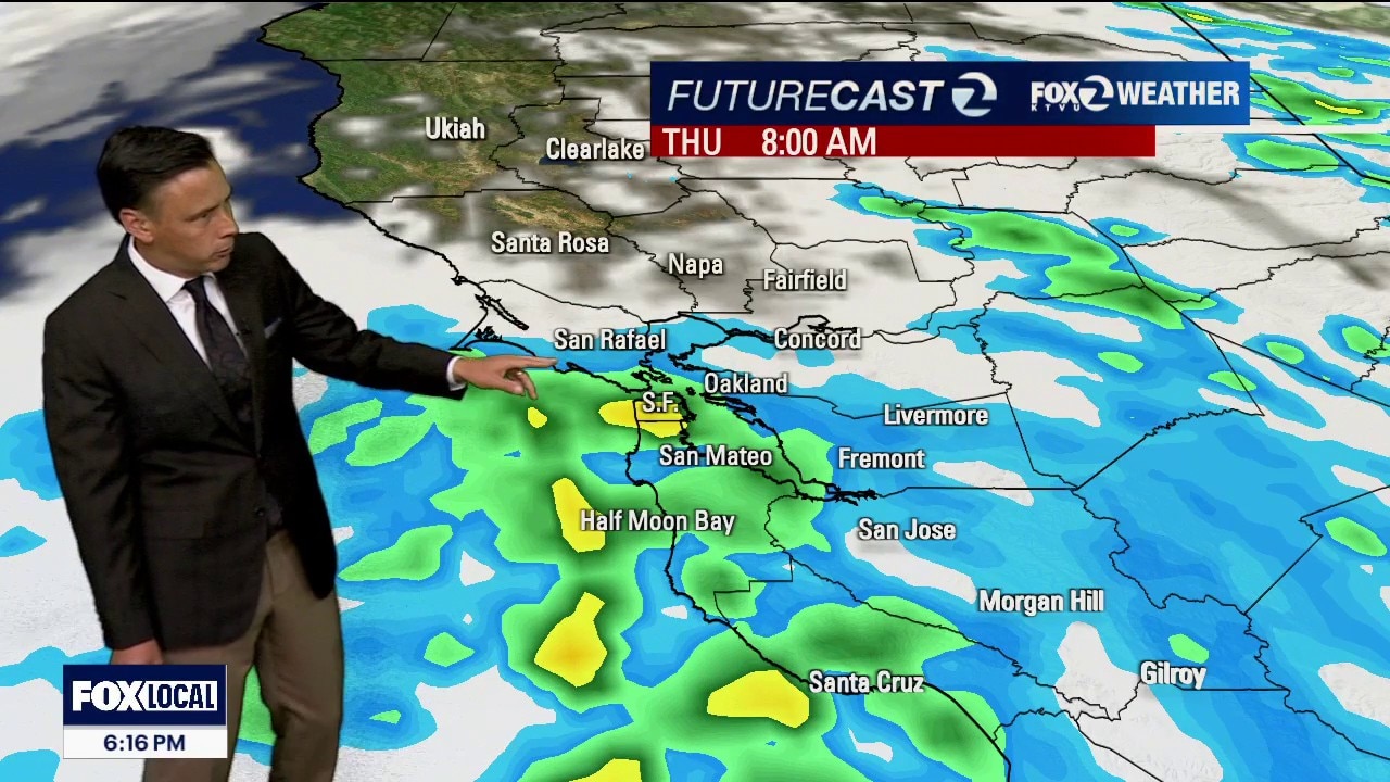
Increasing rain chances Thursday morning
The unsettled pattern continues. Another band of moisture is scheduled to arrive early Thursday morning. Rain chances will be increasing and the morning commute could be impacted. Showers should taper later in the day. Weather looks good for the upcoming weekend. Temperatures will be warming up again.
The unsettled pattern continues. Another band of moisture is scheduled to arrive early Thursday morning. Rain chances will be increasing and the morning commute could be impacted. Showers should taper later in the day. Weather looks good for the upcoming weekend. Temperatures will be warming up again.
Unseasonably Cold Storm Threatens Scattered Thunderstorms Through Thursday
An unseasonably cold storm system is swirling directly over Northern California, generating a bizarre mix of rough seas, mountain gales, lightning and local rain. Tonight & Wednesday: Isolated Storms & Dangerous Coastlines The Storm Threat: Scattered showers and isolated thunderstorms are actively moving through the North Bay and East Bay with the highest lightning threat near Napa and Livermore through tonight. Mountain Gales: Gusts of 30–40 mph (and up to 50 mph) along the coast and across the North Bay & East Bay hills tonight. Dangerous Seas: Powerful gale-force winds are building massive, rough waves of 12-15 feet through Wednesday morning. Boaters and beachgoers must use extreme caution. Beach Hazard Statement in effect until 9 AM Wednesday. Wednesday: We do it all over again. Temperatures will stay chilly, only in the 50s and 60s at the coast and 60s to low 70s inland. Another round of scattered showers and a few weak afternoon thunderstorms will pop up, especially for the interior Bay Area.
An unseasonably cold storm system is swirling directly over Northern California, generating a bizarre mix of rough seas, mountain gales, lightning and local rain. Tonight & Wednesday: Isolated Storms & Dangerous Coastlines The Storm Threat: Scattered showers and isolated thunderstorms are actively moving through the North Bay and East Bay with the highest lightning threat near Napa and Livermore through tonight. Mountain Gales: Gusts of 30–40 mph (and up to 50 mph) along the coast and across the North Bay & East Bay hills tonight. Dangerous Seas: Powerful gale-force winds are building massive, rough waves of 12-15 feet through Wednesday morning. Boaters and beachgoers must use extreme caution. Beach Hazard Statement in effect until 9 AM Wednesday. Wednesday: We do it all over again. Temperatures will stay chilly, only in the 50s and 60s at the coast and 60s to low 70s inland. Another round of scattered showers and a few weak afternoon thunderstorms will pop up, especially for the interior Bay Area.
Gusty winds
The cool weather pattern will be reinforced by a system moving in from the north. Patchy drizzle could return early Tuesday morning. The afternoon forecast features partly sunny skies. Highs should range from the mid 50s to the low 70s. Winds will also be increasing later in the day. Gusts could approach 40 mph.
The cool weather pattern will be reinforced by a system moving in from the north. Patchy drizzle could return early Tuesday morning. The afternoon forecast features partly sunny skies. Highs should range from the mid 50s to the low 70s. Winds will also be increasing later in the day. Gusts could approach 40 mph.
Weather Forecast for Monday, May 25
A big serving of clouds will blanket most of the Bay Area Monday morning. Spotty drizzle could also return. Partly sunny skies are expected later in the day. The cooling trend continues. Highs should range from the upper 50s to the low 70s.
A big serving of clouds will blanket most of the Bay Area Monday morning. Spotty drizzle could also return. Partly sunny skies are expected later in the day. The cooling trend continues. Highs should range from the upper 50s to the low 70s.
Cooler Memorial Day
A big serving of clouds will blanket most of the Bay Area Monday morning. Spotty drizzle could also return. Partly sunny skies are expected later in the day. The cooling trend continues. Highs should range from the upper 50s to the low 70s.
A big serving of clouds will blanket most of the Bay Area Monday morning. Spotty drizzle could also return. Partly sunny skies are expected later in the day. The cooling trend continues. Highs should range from the upper 50s to the low 70s.
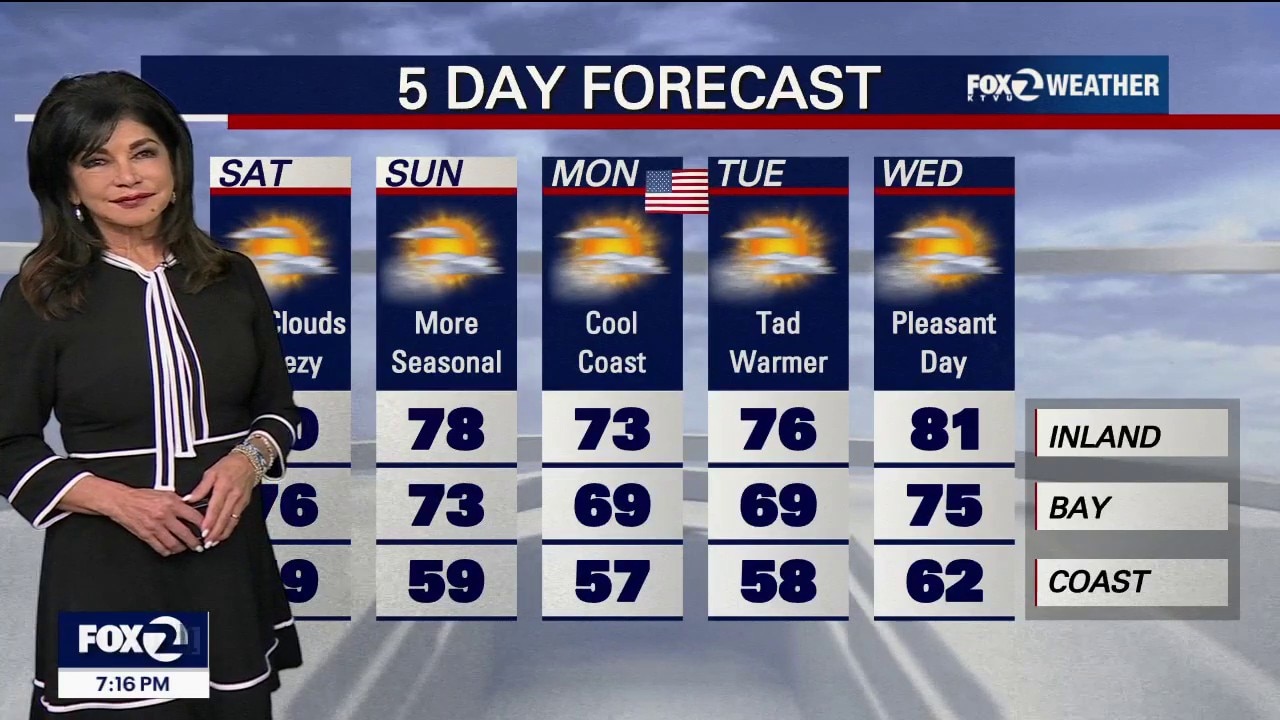
Beach Blanket Chills: Coast stays locked in the 50s for the Holiday Weekend
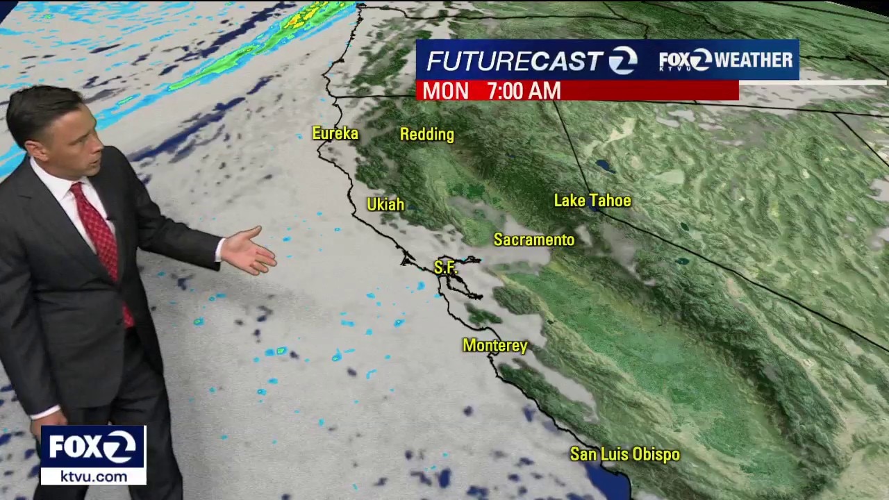
Sunday: Expect carbon-copy weather. The only change is that the North Bay fog will clear out a little earlier in the morning compared to today. West winds 10-20 MPH Memorial Day Monday: The marine layer gets even deeper, pushing thick fog way inland. Widespread morning clouds will be slow to clear. Expect cool, cloudy beaches in the 50s, bayshores in the low 60s, and only the furthest interior spots reaching the 70s. Tuesday: A low-pressure system is now expected to pass to our north, which will cut off our ocean air and trigger a dry, northwesterly breeze. This wind shift will cause temperatures to warm on Tuesday, kicking off a modest warming trend.
Sunday: Expect carbon-copy weather. The only change is that the North Bay fog will clear out a little earlier in the morning compared to today. West winds 10-20 MPH Memorial Day Monday: The marine layer gets even deeper, pushing thick fog way inland. Widespread morning clouds will be slow to clear. Expect cool, cloudy beaches in the 50s, bayshores in the low 60s, and only the furthest interior spots reaching the 70s. Tuesday: A low-pressure system is now expected to pass to our north, which will cut off our ocean air and trigger a dry, northwesterly breeze. This wind shift will cause temperatures to warm on Tuesday, kicking off a modest warming trend.
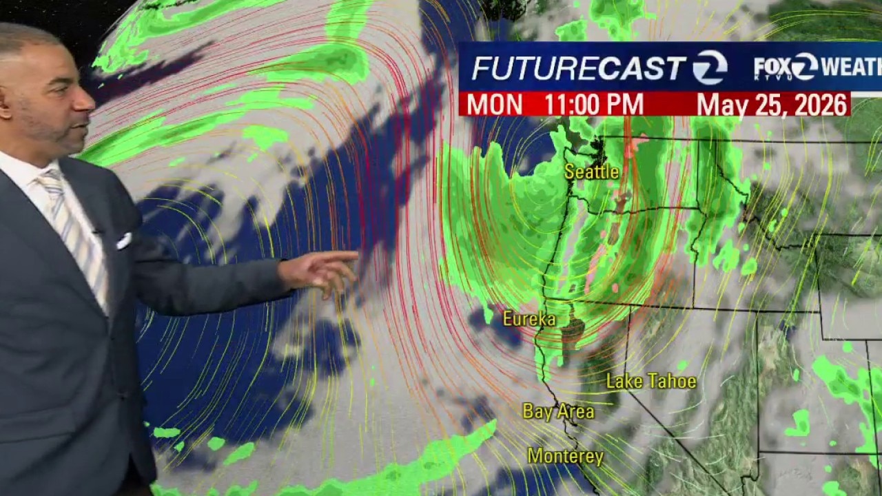
Holiday Cool-Down: Widespread Fog Floods the Bay for Memorial Day Weekend
Tonight: The fog is moving fast. Thick low clouds are currently spilling through the Petaluma Gap, the Golden Gate, and across the Monterey Bay region. Only the highest mountain peaks and the far eastern edge of Contra Costa County will escape the gray blanket by morning. Saturday & Sunday: Expect a gray start to the holiday weekend. Low clouds will be slow to clear each morning, keeping afternoon temperatures very seasonal. Expect upper 50s to mid-60s on the coast, 60s to low 70s around the Bay, and upper 70s to mid-80s far inland. Patchy coastal drizzle is possible both nights. Memorial Day Monday: We start mild, but a cold front approaches late in the day, cranking up the afternoon ocean breezes. No Coastal clearing in the 50s, unseasonably cool Inland in the low to mid 70s. Breezy. Tuesday: The cold front sweeps through from north to south. It will bring much cooler temperatures and a round of widespread drizzle or light rain to the Bay Area and Central Coast. Enjoy your holiday weekend, but be safe!
Tonight: The fog is moving fast. Thick low clouds are currently spilling through the Petaluma Gap, the Golden Gate, and across the Monterey Bay region. Only the highest mountain peaks and the far eastern edge of Contra Costa County will escape the gray blanket by morning. Saturday & Sunday: Expect a gray start to the holiday weekend. Low clouds will be slow to clear each morning, keeping afternoon temperatures very seasonal. Expect upper 50s to mid-60s on the coast, 60s to low 70s around the Bay, and upper 70s to mid-80s far inland. Patchy coastal drizzle is possible both nights. Memorial Day Monday: We start mild, but a cold front approaches late in the day, cranking up the afternoon ocean breezes. No Coastal clearing in the 50s, unseasonably cool Inland in the low to mid 70s. Breezy. Tuesday: The cold front sweeps through from north to south. It will bring much cooler temperatures and a round of widespread drizzle or light rain to the Bay Area and Central Coast. Enjoy your holiday weekend, but be safe!