


Chilly, hazy
Today will be chilly and hazy. Temps in the 50s and 60s.
Today will be chilly and hazy. Temps in the 50s and 60s.

When is the official start of winter? Here's why meteorological winter begins on December 1
Calendars found in homes across the country usually say winter begins on Dec. 21, when in reality the season starts three weeks earlier on Dec. 1.
Calendars found in homes across the country usually say winter begins on Dec. 21, when in reality the season starts three weeks earlier on Dec. 1.


Another round of fog
Fog will resurface for the Monday morning commute...especially in some of the inland valleys. After a chilly start (30s & 40s), we are expecting a mixture of sun and clouds later in the day. Highs should range from the low 50s to the low 60s. We are tracking a system that could boost the wind speeds by Wednesday.
Fog will resurface for the Monday morning commute...especially in some of the inland valleys. After a chilly start (30s & 40s), we are expecting a mixture of sun and clouds later in the day. Highs should range from the low 50s to the low 60s. We are tracking a system that could boost the wind speeds by Wednesday.


Chilly, foggy start improving by afternoon
We are joined by a chilly, foggy start with temperatures in the 40s. Skies will turn partly cloudy for the afternoon with cool daytime highs, ranging from low 50s to low 60s. Hazardous conditions continue along our coast through 10 PM, with an increased risk of sneaker waves and rip currents.
We are joined by a chilly, foggy start with temperatures in the 40s. Skies will turn partly cloudy for the afternoon with cool daytime highs, ranging from low 50s to low 60s. Hazardous conditions continue along our coast through 10 PM, with an increased risk of sneaker waves and rip currents.


One More BIG Foggy Day!
- One more day of persistent fog and stratus in the North Bay (Sunday). - Gusty offshore winds across the North Bay interior Wednesday morning. - Beach Hazard Alert until Sunday 10 PM. Waves 13-18 feet. I expect this to be continued through Monday (possibly longer). Tule fog continues through this weekend with solid moisture working its way into the North Bay valleys as well. Once again had to bring down the temp forecast for these areas today. Persistent fog and stratus can be expected again tomorrow with at least a better chance for earlier clearing. Elsewhere, temperatures around seasonal normals continue with quiet conditions and mostly clear skies. A pattern change will less local tule fog and more seasonal temps beginning Monday with offshore winds by Wednesday with minimal impact expect low humidity.
- One more day of persistent fog and stratus in the North Bay (Sunday). - Gusty offshore winds across the North Bay interior Wednesday morning. - Beach Hazard Alert until Sunday 10 PM. Waves 13-18 feet. I expect this to be continued through Monday (possibly longer). Tule fog continues through this weekend with solid moisture working its way into the North Bay valleys as well. Once again had to bring down the temp forecast for these areas today. Persistent fog and stratus can be expected again tomorrow with at least a better chance for earlier clearing. Elsewhere, temperatures around seasonal normals continue with quiet conditions and mostly clear skies. A pattern change will less local tule fog and more seasonal temps beginning Monday with offshore winds by Wednesday with minimal impact expect low humidity.


Serving Up Leftovers...Fog AND Sun!
After another unseasonably cool day (highs in the 40s and 50s!) the stubborn fog will lift earlier Saturday and Sunday! This will result in near seasonal temperatures. - Mild and quiet, beautiful weather through the weekend. - Pattern continues into much of next week. Breezy offshore winds in the North Bay interior Wed/Thu. Minimal impact. - Beach Hazard Alert in effect until Sunday at 10PM. Waves 13-18 feet. Do not turn your back to the ocean! - Need to look just beyond the 7 day forecast for next chance of rain. High uncertainty if we`ll actually get any then. Looks like perhaps, December 9th. Not a slam dunk! Stagnant pattern remains. Beautiful weekend full steam ahead, unless you`re caught up in the Tule fog and stratus in the interior East Bay and North Bay. These locations will hold on to fog and clouds through much of the day today and will likely copy/paste tomorrow as well. Elsewhere we`re seeing temps around seasonal normals with highs in the upper 50s and lower 60s. Have a great Saturday!
After another unseasonably cool day (highs in the 40s and 50s!) the stubborn fog will lift earlier Saturday and Sunday! This will result in near seasonal temperatures. - Mild and quiet, beautiful weather through the weekend. - Pattern continues into much of next week. Breezy offshore winds in the North Bay interior Wed/Thu. Minimal impact. - Beach Hazard Alert in effect until Sunday at 10PM. Waves 13-18 feet. Do not turn your back to the ocean! - Need to look just beyond the 7 day forecast for next chance of rain. High uncertainty if we`ll actually get any then. Looks like perhaps, December 9th. Not a slam dunk! Stagnant pattern remains. Beautiful weekend full steam ahead, unless you`re caught up in the Tule fog and stratus in the interior East Bay and North Bay. These locations will hold on to fog and clouds through much of the day today and will likely copy/paste tomorrow as well. Elsewhere we`re seeing temps around seasonal normals with highs in the upper 50s and lower 60s. Have a great Saturday!


49ers prepare for Browns, inclement Cleveland weather Sunday
The San Francisco 49ers finalized their preps and game plan ahead of Sunday's 10am PST kickoff against the Browns in Cleveland. The weather forecast calls for a rainy mix and gusty winds.
The San Francisco 49ers finalized their preps and game plan ahead of Sunday's 10am PST kickoff against the Browns in Cleveland. The weather forecast calls for a rainy mix and gusty winds.


Dry, sun
Today will be dry and sunny. Temps in 60s.
Today will be dry and sunny. Temps in 60s.


Another round of fog
The fog will return to the forecast Friday morning. Partly sunny skies are expected later in the day. Highs should range from the upper 50 to the mid 60s. The dry weather stretch remains in place through the weekend.
The fog will return to the forecast Friday morning. Partly sunny skies are expected later in the day. Highs should range from the upper 50 to the mid 60s. The dry weather stretch remains in place through the weekend.


Dry weather stretch continues
The dry weather stretch in the Bay Area is expected to continue into the weekend.
The dry weather stretch in the Bay Area is expected to continue into the weekend.

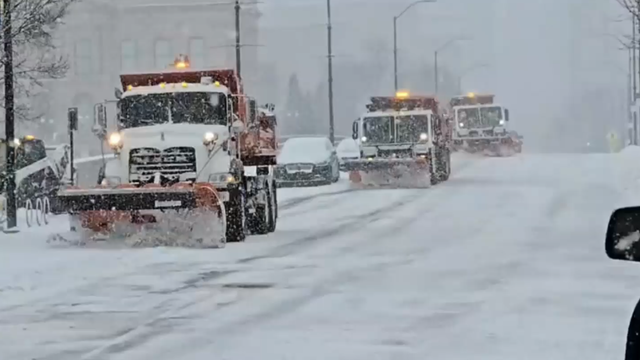
Intense lake-effect snow unleashes treacherous Thanksgiving travel conditions as winter storms turn deadly
Lake-effect snow warnings are in effect across Wisconsin, Michigan, Ohio, Pennsylvania and western New York on Thanksgiving Day.
Lake-effect snow warnings are in effect across Wisconsin, Michigan, Ohio, Pennsylvania and western New York on Thanksgiving Day.


Quake hits San Juan Bautista in Central California
An earthquake with a magnitude of 4.3 struck Central California on Thanksgiving Day, according to the US Geological Survey.
An earthquake with a magnitude of 4.3 struck Central California on Thanksgiving Day, according to the US Geological Survey.


The storm that took down the Edmund Fitzgerald
The Edmund Fitzgerald still sits at the bottom of Lake Superior, submerged in 535 feet of water, about 17 miles north-northwest of Whitefish Point, Michigan.
The Edmund Fitzgerald still sits at the bottom of Lake Superior, submerged in 535 feet of water, about 17 miles north-northwest of Whitefish Point, Michigan.


Morning clouds, fog
Morning clouds and fog. Temps in the 60s.
Morning clouds and fog. Temps in the 60s.


Dry Thanksgiving forecast
Patchy, dense fog should resurface Thursday morning. We are expecting more sunshine later in the day. Highs should range from the upper 50s to the upper 60s. A Spare the Alert is in effect through Thursday. Our dry weather stretch should remain in place this weekend. Have a great Thanksgiving! -Mark
Patchy, dense fog should resurface Thursday morning. We are expecting more sunshine later in the day. Highs should range from the upper 50s to the upper 60s. A Spare the Alert is in effect through Thursday. Our dry weather stretch should remain in place this weekend. Have a great Thanksgiving! -Mark


Winter Spare the Air alert in effect in Bay Area through Thanksgiving night
Holiday gatherings often mean additional traffic, busy kitchens, and more activity around the home. With stagnant air overhead, conditions are favorable for pollution to build quickly.
Holiday gatherings often mean additional traffic, busy kitchens, and more activity around the home. With stagnant air overhead, conditions are favorable for pollution to build quickly.
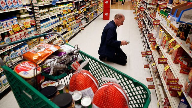

Thanksgiving meal costs show mixed bag due to retail deals and supply issues
Despite a predicted rise in wholesale turkey costs due to low flock numbers and bird flu, many stores are offering discounted or free turkeys, though consumers should expect significantly higher prices—up to 60%—on numerous side dish ingredients like cranberry sauce and veggie trays.
Despite a predicted rise in wholesale turkey costs due to low flock numbers and bird flu, many stores are offering discounted or free turkeys, though consumers should expect significantly higher prices—up to 60%—on numerous side dish ingredients like cranberry sauce and veggie trays.


Don't light your firewood
With colder nights settling in across the Bay Area — and Thanksgiving just around the corner — many families are preparing to light up their fireplaces for a warm, cozy holiday. But before you strike that match, the Bay Area Air District (formerly the Bay Area Air Quality Management District) is reminding residents about new wood-burning regulations that could impact when and how you can enjoy that fire.
With colder nights settling in across the Bay Area — and Thanksgiving just around the corner — many families are preparing to light up their fireplaces for a warm, cozy holiday. But before you strike that match, the Bay Area Air District (formerly the Bay Area Air Quality Management District) is reminding residents about new wood-burning regulations that could impact when and how you can enjoy that fire.


Earthquake swarm rattles South Bay
The largest quake was reported around 6:16 a.m. southeast of Gilroy.
The largest quake was reported around 6:16 a.m. southeast of Gilroy.


Dense fog returns Wednesday morning
We are expecting another round of dense fog for parts of the Bay Area Wednesday morning. A Spare the Alert (no wood burning) has been issued for Wednesday - Thursday. Highs should range from the upper 50s to the upper 60s. Your Thanksgiving forecast features scattered clouds. The warmest parts of the Bay Area. could approach 70.
We are expecting another round of dense fog for parts of the Bay Area Wednesday morning. A Spare the Alert (no wood burning) has been issued for Wednesday - Thursday. Highs should range from the upper 50s to the upper 60s. Your Thanksgiving forecast features scattered clouds. The warmest parts of the Bay Area. could approach 70.