


California homeowners can get $3,000 to retrofit their home. What to know:
Experts say one major action California residents can take to reduce the risk of earthquake damage and injuries is to retrofit their home. Now eligible residents can receive up to $3,000 for seismic work. But time is running out to register.
Experts say one major action California residents can take to reduce the risk of earthquake damage and injuries is to retrofit their home. Now eligible residents can receive up to $3,000 for seismic work. But time is running out to register.


Lightning starts house fire in Brentwood
Lightning lit up the skies Wednesday night throughout the Bay Area, and firefighters in Brentwood said one such strike caused a house fire when the electricity hit a weather vane on top of the roof.
Lightning lit up the skies Wednesday night throughout the Bay Area, and firefighters in Brentwood said one such strike caused a house fire when the electricity hit a weather vane on top of the roof.
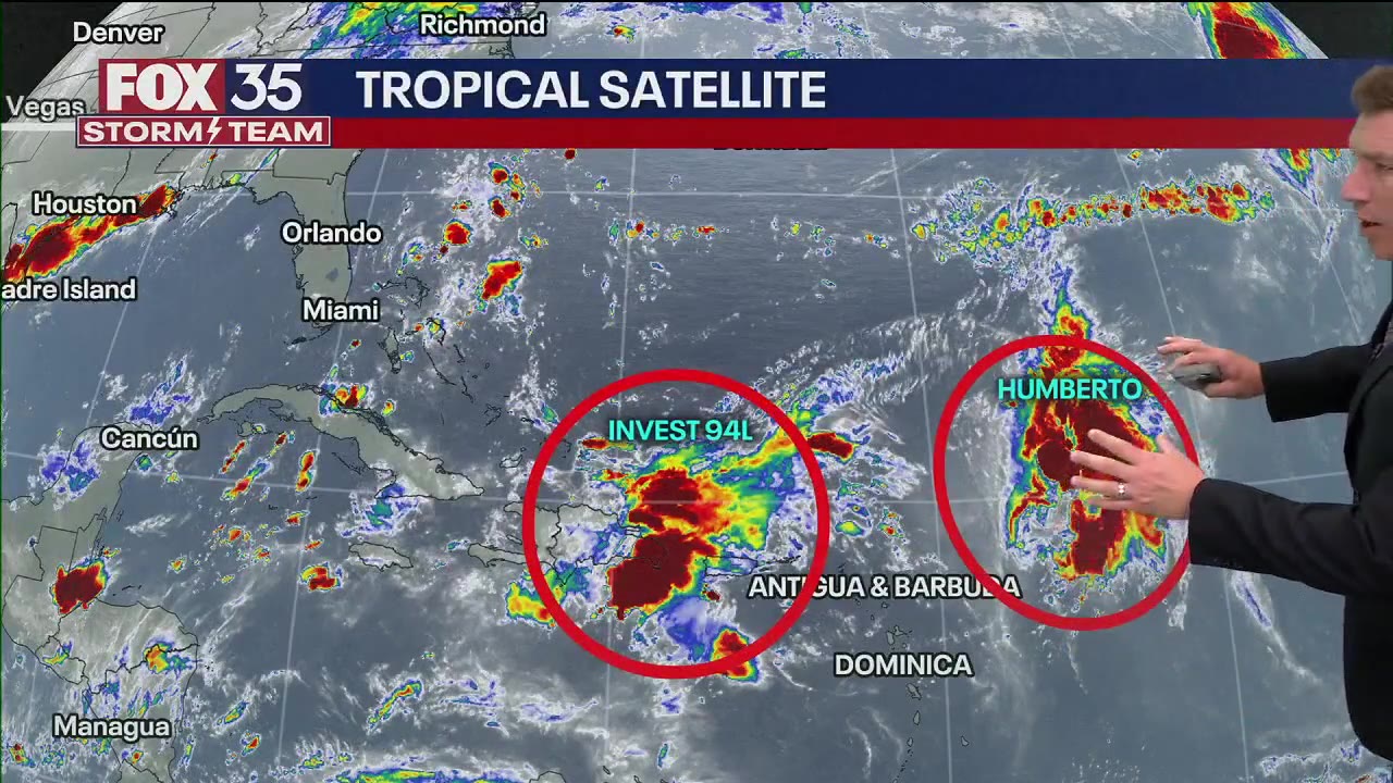

Fujiwhara Effect: What is it, what happens? Will Invest 94L and Tropical Storm Humberto combine?
With things finally heating up in the tropics for the 2025 Atlantic hurricane season, the FOX 35 Storm Team answers a question many people have had on their minds: Can several hurricanes merge into a single, stronger hurricane?
With things finally heating up in the tropics for the 2025 Atlantic hurricane season, the FOX 35 Storm Team answers a question many people have had on their minds: Can several hurricanes merge into a single, stronger hurricane?


Another quake rumbles through Berkeley
Another small earthquake rumbled through Berkeley early Wednesday morning, following two earlier this week.
Another small earthquake rumbled through Berkeley early Wednesday morning, following two earlier this week.


Morning clouds
Today will see morning clouds. High in the 70s and 80s.
Today will see morning clouds. High in the 70s and 80s.


Showers moving out
The thunderstorms we were tracking Wednesday evening could linger into early Thursday morning. Partly to mostly cloudy skies are expected for your Thursday. Highs should range from the mid 60s to the mid 80s. Warmer temperatures will highlight the Friday forecast.
The thunderstorms we were tracking Wednesday evening could linger into early Thursday morning. Partly to mostly cloudy skies are expected for your Thursday. Highs should range from the mid 60s to the mid 80s. Warmer temperatures will highlight the Friday forecast.


Wednesday night thunderstorms
Thunderstorms moved into parts of the East Bay Wednesday night.
Thunderstorms moved into parts of the East Bay Wednesday night.


Wednesday night thunderstorms
Thunderstorms rolled into parts of the Bay Area Wednesday evening
Thunderstorms rolled into parts of the Bay Area Wednesday evening


Showers moving out overnight
We get a break from the heat! Shower chances will remain in the Bay Area forecast overnight. Your Thursday forecast features partly to mostly cloudy skies. Highs should range from the mid 60s to the mid 80s.
We get a break from the heat! Shower chances will remain in the Bay Area forecast overnight. Your Thursday forecast features partly to mostly cloudy skies. Highs should range from the mid 60s to the mid 80s.


Showers have arrived
Ample shower activity has been observed across Monterey and San Benito counties this morning with some strong thunderstorms in the southern portion of these counties. Rainfall has been steady, but hasn't brought a flooding concern over the dry soil. While the main show is this morning, the chance for showers and thunderstorms continues throughout the Bay Area this afternoon and evening. Thursday morning will start cloudy with a chance of unsettled weather before afternoon clearing.
Ample shower activity has been observed across Monterey and San Benito counties this morning with some strong thunderstorms in the southern portion of these counties. Rainfall has been steady, but hasn't brought a flooding concern over the dry soil. While the main show is this morning, the chance for showers and thunderstorms continues throughout the Bay Area this afternoon and evening. Thursday morning will start cloudy with a chance of unsettled weather before afternoon clearing.


Cause of death revealed for 2 missing hikers found in Colorado wilderness
The two were reported missing to the Conejos County Sheriff's Office (CCSO) on September 13, but last made contact with their family on September 11.
The two were reported missing to the Conejos County Sheriff's Office (CCSO) on September 13, but last made contact with their family on September 11.


Temps in 80s
Today's temps will be in the 80s.
Today's temps will be in the 80s.


Cooler temperatures ahead
A significant pattern change is in store overnight as a cut-off low pressure system with ample subtropical moisture pushes in from the south. We can say with high confidence that this will bring significant cloud cover, cooler temperatures and higher humidity.
A significant pattern change is in store overnight as a cut-off low pressure system with ample subtropical moisture pushes in from the south. We can say with high confidence that this will bring significant cloud cover, cooler temperatures and higher humidity.


Camp Mystic plans to reopen next summer with new Texas safety protocols
The popular Christian summer camp, where 25 young girls and two staffers were killed in the deadly Central Texas flooding, announced its plans in a letter Monday.
The popular Christian summer camp, where 25 young girls and two staffers were killed in the deadly Central Texas flooding, announced its plans in a letter Monday.


Sweltering temps prompt heat advisories in the Bay Area
Tuesday will be the hottest day of the week, with highs ranging from the low 80s to 102 well inland.
Tuesday will be the hottest day of the week, with highs ranging from the low 80s to 102 well inland.


South Carolina man carves 'storm bowls' out of trees brought down by Helene
Helene was the deadliest mainland U.S. hurricane in nearly 20 years, according to the National Hurricane Center.
Helene was the deadliest mainland U.S. hurricane in nearly 20 years, according to the National Hurricane Center.


Warm to hot Tuesday
Tuesday will be the hottest day of the week. Highs should range from the low 80s to 102 well inland. A Spare the Air Alert has been issued for the Bay Area. A cooler system will approach the Bay Area Tuesday night. Shower and thunderstorm chances will be increasing by Wednesday. Update: The National Weather Service issued a Heat Advisory for parts of the Bay Area (Tuesday: 11 am to 7 pm). The advisory will be in effect for San Francisco, the Peninsula, South Bay, and the East Bay.
Tuesday will be the hottest day of the week. Highs should range from the low 80s to 102 well inland. A Spare the Air Alert has been issued for the Bay Area. A cooler system will approach the Bay Area Tuesday night. Shower and thunderstorm chances will be increasing by Wednesday. Update: The National Weather Service issued a Heat Advisory for parts of the Bay Area (Tuesday: 11 am to 7 pm). The advisory will be in effect for San Francisco, the Peninsula, South Bay, and the East Bay.


Aftershock: Magnitude 3.0 earthquake measured near Berkeley
A magnitude 3.0 earthquake in the East Bay was recorded by the U.S. Geological Survey at 6:21 p.m. on Monday.
A magnitude 3.0 earthquake in the East Bay was recorded by the U.S. Geological Survey at 6:21 p.m. on Monday.


4.3 magnitude earthquake shakes near Berkeley, Oakland
DID YOU FEEL IT? The USGS reports the earthquake hit at 2:56 a.m. with an epicenter in Berkeley.
DID YOU FEEL IT? The USGS reports the earthquake hit at 2:56 a.m. with an epicenter in Berkeley.


Temps 80s and 90s
Today's temps will be in the 80s and 90s.
Today's temps will be in the 80s and 90s.