

A clear mild day ahead with light winds moving in
High pressure sliding in briefly today making for nice temps.
High pressure sliding in briefly today making for nice temps.
Sunshine returns
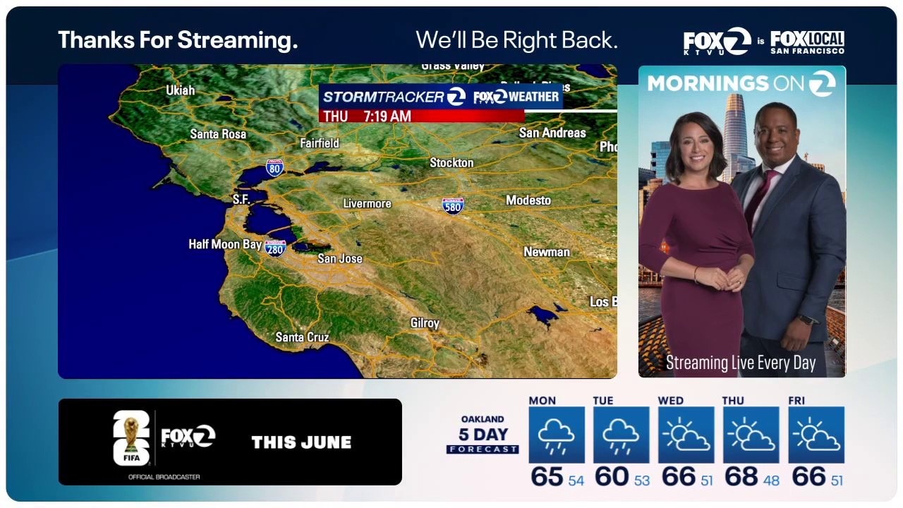
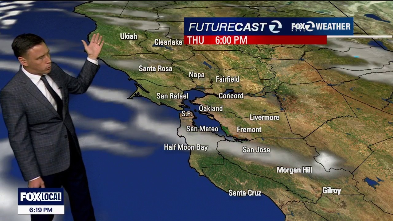
The storm clouds will be moving out of town. Patchy fog will resurface Thursday morning. Mostly sunny skies will highlight the afternoon forecast. Highs should range from the mid 60s to the low 70s.
The storm clouds will be moving out of town. Patchy fog will resurface Thursday morning. Mostly sunny skies will highlight the afternoon forecast. Highs should range from the mid 60s to the low 70s.
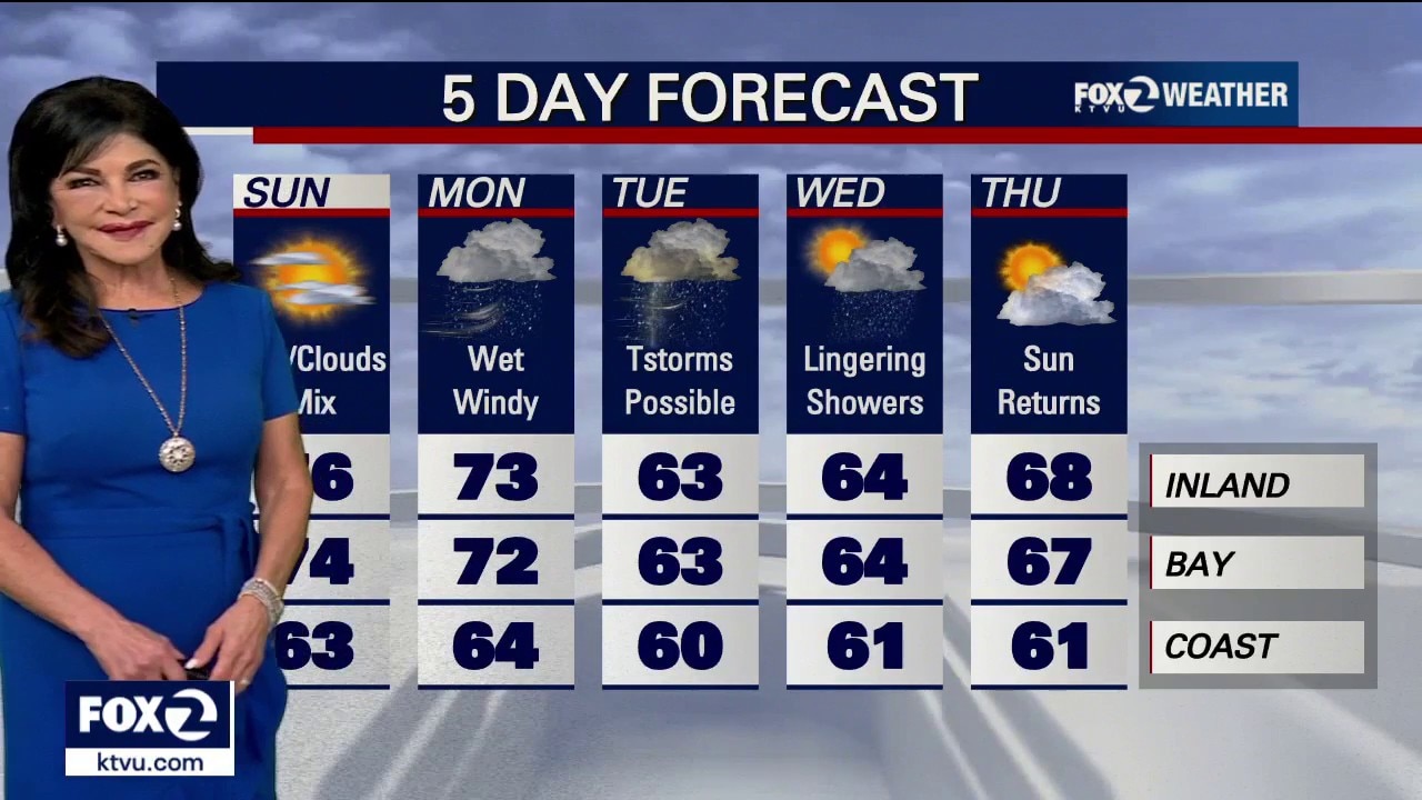
Lingering Wednesday showers
Our unsettled weather stretch continues. Showers will continue to pay us a visit Wednesday morning. The activity should taper later in the day. We are expecting a mixture of sun and clouds during the afternoon. Temperatures should rebound Thursday and Friday.
Our unsettled weather stretch continues. Showers will continue to pay us a visit Wednesday morning. The activity should taper later in the day. We are expecting a mixture of sun and clouds during the afternoon. Temperatures should rebound Thursday and Friday.
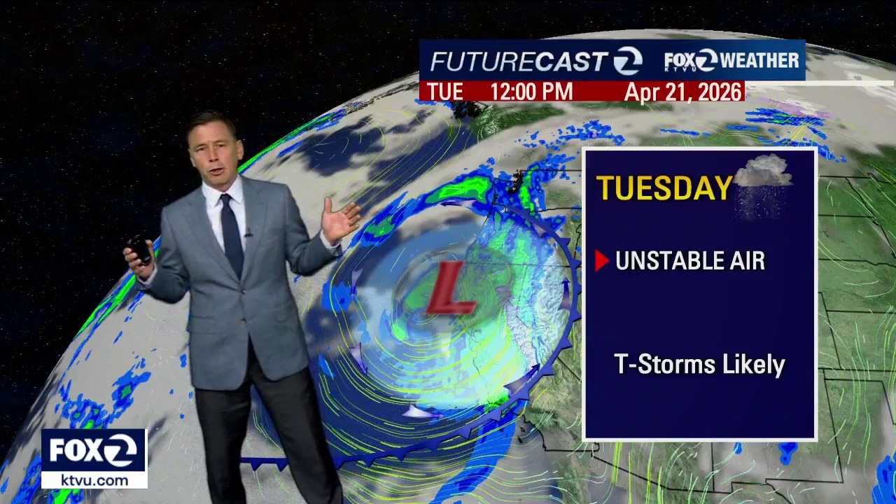
Sun, clouds and thunderstorms joining us today
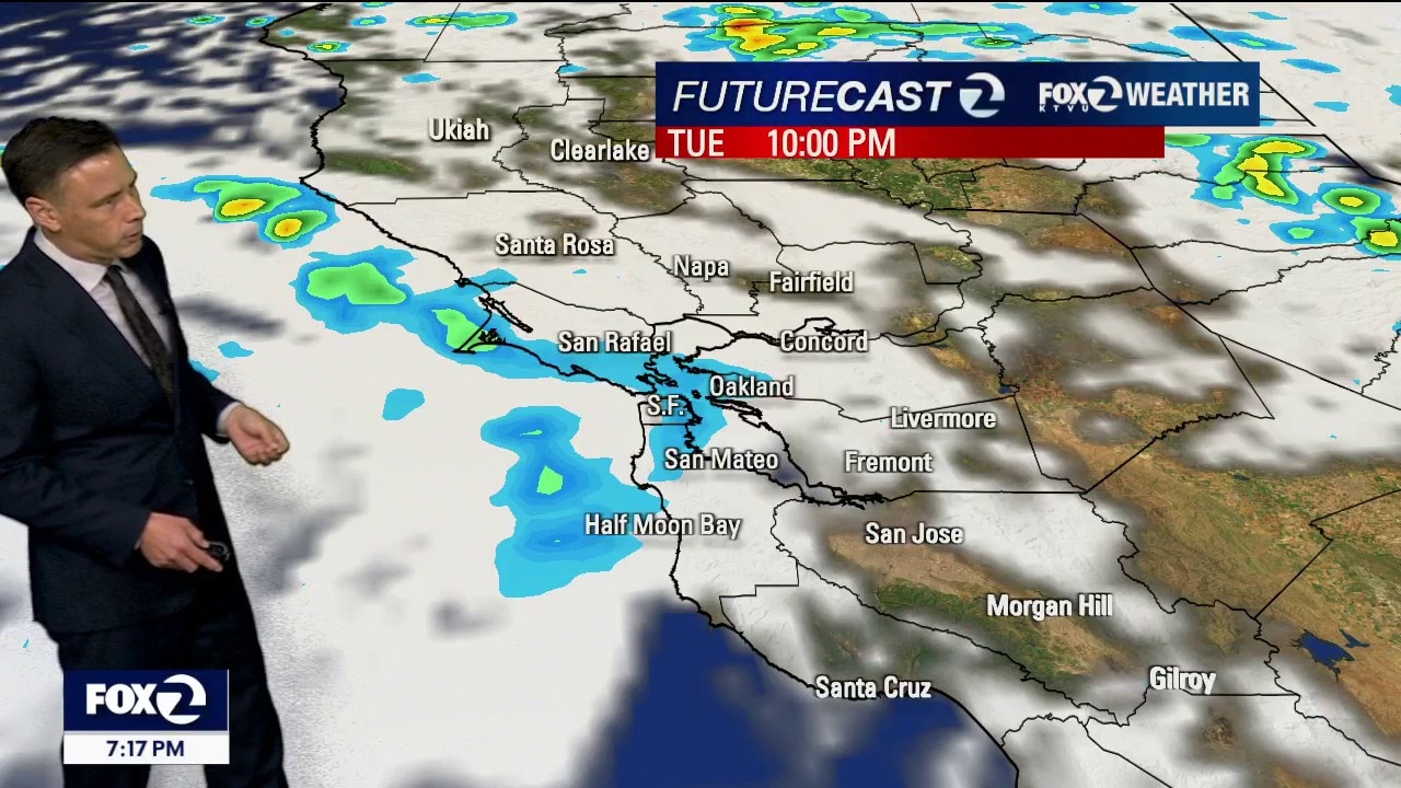
Happy Tuesday everyone, as the storm pass through it will give us sunshine, clouds and the risk of downpours and thunderstorms. We taper off to scattered showers for Wednesday.
Happy Tuesday everyone, as the storm pass through it will give us sunshine, clouds and the risk of downpours and thunderstorms. We taper off to scattered showers for Wednesday.
Chance of thunderstorms
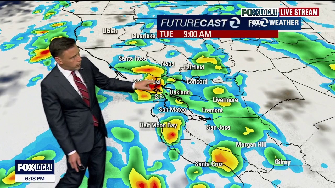
A cold April storm will continue to impact the Bay Area. Showers are expected to move across region Tuesday morning. Thunderstorm chances will also be increasing. Some of the storm cells could produce hail. The shower threat will remain in the Wednesday forecast. Sunshine returns later in the week.
A cold April storm will continue to impact the Bay Area. Showers are expected to move across region Tuesday morning. Thunderstorm chances will also be increasing. Some of the storm cells could produce hail. The shower threat will remain in the Wednesday forecast. Sunshine returns later in the week.

Wet and windy today with thunderstorm risk tomorrow
Happy Monday everyone, widespread showers falling over the bay area will turn into a steady rain for the afternoon commute and evening. Showers and a chance of thunderstorms are in the forecast for Tuesday.
Happy Monday everyone, widespread showers falling over the bay area will turn into a steady rain for the afternoon commute and evening. Showers and a chance of thunderstorms are in the forecast for Tuesday.
Heading back to winter
Another spring storm will impact the Bay Area over the next 3 days. This system will have 3 parts. First part (Mon): Light to moderate rain expected. The cold front, along with a band of heavy rain, moves in late afternoon-evening. Second part (Tue): The cool, unstable part of the system moves in. Thunderstorms chances will be increasing. Third part (Wed): Lingering showers expected. The activity should be decreasing later in the day. Significant snow in the Sierra too! A Winter Storm Watch has already been drafted.
Another spring storm will impact the Bay Area over the next 3 days. This system will have 3 parts. First part (Mon): Light to moderate rain expected. The cold front, along with a band of heavy rain, moves in late afternoon-evening. Second part (Tue): The cool, unstable part of the system moves in. Thunderstorms chances will be increasing. Third part (Wed): Lingering showers expected. The activity should be decreasing later in the day. Significant snow in the Sierra too! A Winter Storm Watch has already been drafted.

Heading back to winter
Another spring storm will impact the Bay Area over the next 3 days. This system will have 3 parts. Frist part (Mon): Light to moderate rain expected. The cold front, along with a band of heavy rain, moves in late afternoon-evening. Second part (Tue): The cool, unstable part of the system moves in. Thunderstorms chances will be increasing. Third part (Wed): Lingering showers expected. The activity should be decreasing later in the day. Significant snow in the Sierra too! A Winter Storm Watch has already been drafted.
Another spring storm will impact the Bay Area over the next 3 days. This system will have 3 parts. Frist part (Mon): Light to moderate rain expected. The cold front, along with a band of heavy rain, moves in late afternoon-evening. Second part (Tue): The cool, unstable part of the system moves in. Thunderstorms chances will be increasing. Third part (Wed): Lingering showers expected. The activity should be decreasing later in the day. Significant snow in the Sierra too! A Winter Storm Watch has already been drafted.
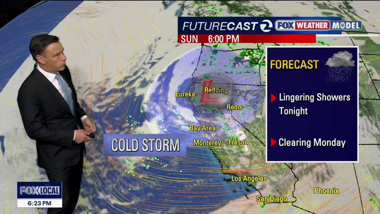
Cloudier, cooler today ahead of wet weather tomorrow
Mostly cloudy, seasonal temperatures are in store for your Bay Area Sunday before wet weather returns on Monday. The rain arrives in the north bay early then slowly works south throughout the day. Risk of isolated thunderstorms join us on Tuesday. Lingering showers continue on Wednesday.
Mostly cloudy, seasonal temperatures are in store for your Bay Area Sunday before wet weather returns on Monday. The rain arrives in the north bay early then slowly works south throughout the day. Risk of isolated thunderstorms join us on Tuesday. Lingering showers continue on Wednesday.
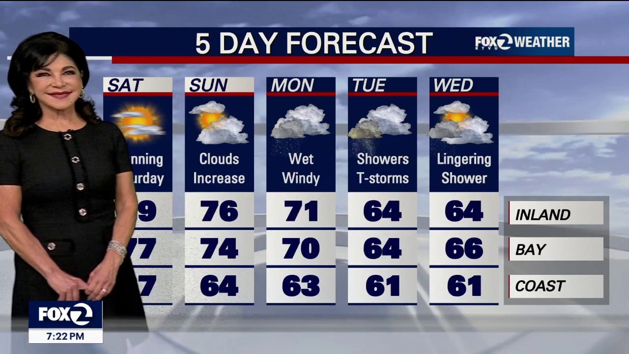
Sun and clouds and Cooler Sunday
After a gorgeous Saturday, expect a bit cooler Sunday with clouds and sun mix. The upcoming storm has slowed down by about half a day, which means, rain arriving a bit later on Monday.. However, the system is packing a punch for Tuesday, bringing a risk of heavy rain, thunderstorms and minor flooding. Monday: The Slow Start Morning: Rain kicks off in the North Bay early Monday. The Rest of Us: Most will likely see very little rain during the day on Monday. Total Shift: The "main event" cold front is now timed for Tuesday morning.
After a gorgeous Saturday, expect a bit cooler Sunday with clouds and sun mix. The upcoming storm has slowed down by about half a day, which means, rain arriving a bit later on Monday.. However, the system is packing a punch for Tuesday, bringing a risk of heavy rain, thunderstorms and minor flooding. Monday: The Slow Start Morning: Rain kicks off in the North Bay early Monday. The Rest of Us: Most will likely see very little rain during the day on Monday. Total Shift: The "main event" cold front is now timed for Tuesday morning.

Enjoy the warm weather while it lasts
Happy weekend everyone. We will be joined by high clouds and unseasonably warm temperatures today before cloudier, cooler weather arrives tomorrow and rain returns on Monday.
Happy weekend everyone. We will be joined by high clouds and unseasonably warm temperatures today before cloudier, cooler weather arrives tomorrow and rain returns on Monday.
Weekend warm up; muddy Monday
Saturday is the winner with high temperatures in the 70s and approaching 80 in Gilroy. Cooler mostly cloudy skies Sunday before rain arrives Monday.
Saturday is the winner with high temperatures in the 70s and approaching 80 in Gilroy. Cooler mostly cloudy skies Sunday before rain arrives Monday.
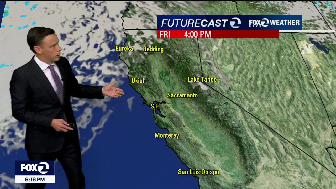
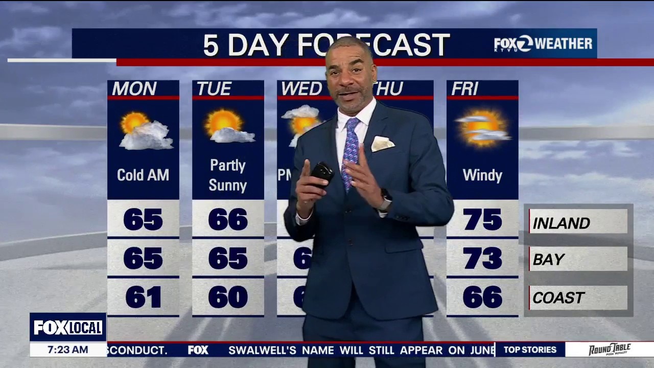
Warmer forecast
Your Friday forecast features sunny skies and warmer temperatures. Highs should range from the mid 60s to the mid 70s. Winds are expected to be strongest during the morning hours. Gusts could approach 35 mph. Saturday should be the warmest day of the week.
Your Friday forecast features sunny skies and warmer temperatures. Highs should range from the mid 60s to the mid 70s. Winds are expected to be strongest during the morning hours. Gusts could approach 35 mph. Saturday should be the warmest day of the week.

From blustery to brisk to beautiful!
Winds will gradually relax overnight before increasing again Friday morning. Less wind in the afternooon with warmer temperatures and blue skies.
Winds will gradually relax overnight before increasing again Friday morning. Less wind in the afternooon with warmer temperatures and blue skies.
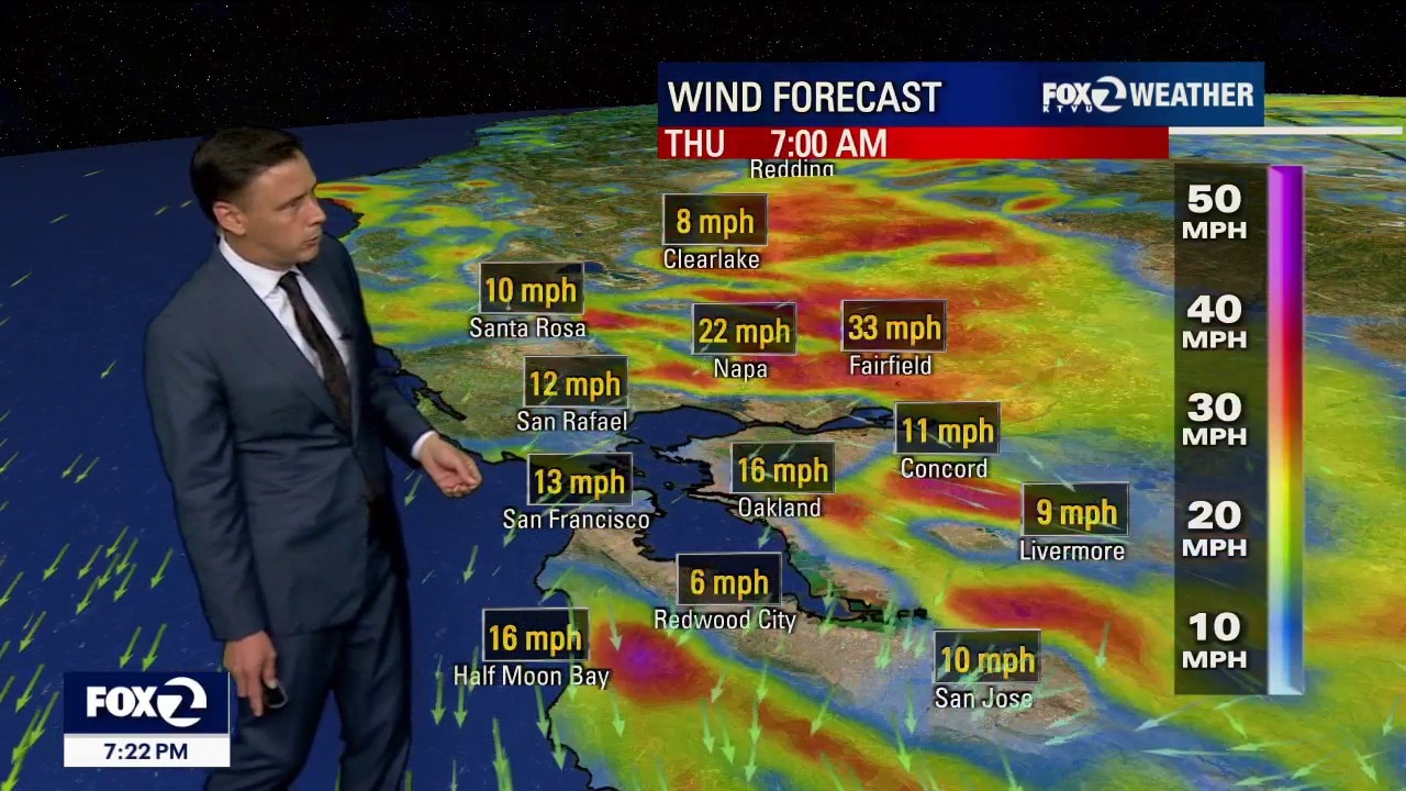
Stronger winds
A system will drop into Nevada over the next 24 hours. As high pressure builds offshore, we are expecting the winds to be picking up. Gusts could approach 40 mph across parts of the Bay Area....especially in the hills. A warming trend will lead us to the weekend. Our next chance of showers moves in late Sunday afternoon/evening.
A system will drop into Nevada over the next 24 hours. As high pressure builds offshore, we are expecting the winds to be picking up. Gusts could approach 40 mph across parts of the Bay Area....especially in the hills. A warming trend will lead us to the weekend. Our next chance of showers moves in late Sunday afternoon/evening.
A beautiful day here in the Bay Area
Partly cloudy conditions and temps in the 60s.
Partly cloudy conditions and temps in the 60s.
Bay area mood swing...morning drizzle to breezy, blue skies
Start your Wednesday with a deck of clouds and spotty drizzle, clearing to partly sunny skies and breezy west winds 10-20 mph. Temperatures will be near average with gradual warming through Saturday.
Start your Wednesday with a deck of clouds and spotty drizzle, clearing to partly sunny skies and breezy west winds 10-20 mph. Temperatures will be near average with gradual warming through Saturday.
A break from the rain
Our old system is moving out of the picture. Patchy fog will resurface Tuesday morning. The afternoon forecast features mostly sunny skies. Highs should range from the upper 50s to the upper 60s. A weak system moves into the Bay Area Wednesday. The slight chance of showers has been added to the forecast.
Our old system is moving out of the picture. Patchy fog will resurface Tuesday morning. The afternoon forecast features mostly sunny skies. Highs should range from the upper 50s to the upper 60s. A weak system moves into the Bay Area Wednesday. The slight chance of showers has been added to the forecast.
Rain and Clouds Clearing Out
Temps on the cool side as we start our work week.
Temps on the cool side as we start our work week.
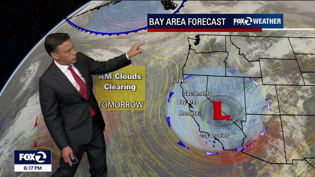
Rain is moving out
After a stormy weekend, our weather pattern is shifting a bit. Shower chances remain in the Monday morning forecast. Partly to mostly sunny skies are expected later in the day. Highs should range from the upper 50s to the mid 60s.
After a stormy weekend, our weather pattern is shifting a bit. Shower chances remain in the Monday morning forecast. Partly to mostly sunny skies are expected later in the day. Highs should range from the upper 50s to the mid 60s.