


Decimated San Francisco immigration court to close at end of year
The San Francisco immigration court building — where nearly two dozen judges have since been fired or retired – is set to close in January 2027.
The San Francisco immigration court building — where nearly two dozen judges have since been fired or retired – is set to close in January 2027.


Demonstrators gather in Oakland, SF to protest woman's fatal shooting by ICE
Dozens of protesters gathered in Oakland Wednesday night to demonstrate against the shooting death of a woman at the hands of an Immigration and Customs Enforcement (ICE) agent in Minneapolis earlier in the day.
Dozens of protesters gathered in Oakland Wednesday night to demonstrate against the shooting death of a woman at the hands of an Immigration and Customs Enforcement (ICE) agent in Minneapolis earlier in the day.


Demonstrators in Oakland protest ICE killing of Renee Nicole Good
Dozens of people gathered in Oakland Wednesday night to protest the killing of Renee Nicole Good, who was killed by ICE agents in Minneapolis earlier in the day. There are disputes between federal officials and local authorities over how this deadly incident unfolded.
Dozens of people gathered in Oakland Wednesday night to protest the killing of Renee Nicole Good, who was killed by ICE agents in Minneapolis earlier in the day. There are disputes between federal officials and local authorities over how this deadly incident unfolded.


Nick Reiner arraignment postponed again
Nick Reiner, accused of killing his parents Rob and Michele Reiner, appeared in court on Wednesday but did not enter a plea, due to the departure of his legal counsel, Alan Jackson. Jackson said circumstances outside of Nick's control meant they would no longer be able to work together.
Nick Reiner, accused of killing his parents Rob and Michele Reiner, appeared in court on Wednesday but did not enter a plea, due to the departure of his legal counsel, Alan Jackson. Jackson said circumstances outside of Nick's control meant they would no longer be able to work together.


Suspect identified in Antioch shooting of 11-year-old
The man accused of shooting an 11-year-old girl in the head while she rode in the passenger seat of her family's car this week in Antioch has been identified by the police.
The man accused of shooting an 11-year-old girl in the head while she rode in the passenger seat of her family's car this week in Antioch has been identified by the police.


San Jose group hosts celebration for unhoused women
A San Jose group hosted a celebration on Wednesday for dozens of unhoused and recently housed women, offering a warm meal, gifts, and a sense of community.
A San Jose group hosted a celebration on Wednesday for dozens of unhoused and recently housed women, offering a warm meal, gifts, and a sense of community.


Antioch police ID suspect in shooting of 11-year-old girl
The man accused of shooting an 11-year-old girl in the head while she rode in the passenger seat of her family's car this week in Antioch has been identified by the police.
The man accused of shooting an 11-year-old girl in the head while she rode in the passenger seat of her family's car this week in Antioch has been identified by the police.


San Jose group hosts celebration for unhoused women
A San Jose group hosted a celebration on Wednesday for dozens of unhoused and recently housed women, offering a warm meal, gifts, and a sense of community.
A San Jose group hosted a celebration on Wednesday for dozens of unhoused and recently housed women, offering a warm meal, gifts, and a sense of community.


Oakland family seeks justice after woman critically injured in hit-and-run
An Oakland family is demanding answers after a hit-and-run crash left their loved one fighting for her life.
An Oakland family is demanding answers after a hit-and-run crash left their loved one fighting for her life.


Review shows crime is down in Oakland
Oakland's mayor and city leaders announced that in 2025, violent crime had fallen 25% compared to the year before, even with an understaffed police force. However, some residents are calling on the city to do more.
Oakland's mayor and city leaders announced that in 2025, violent crime had fallen 25% compared to the year before, even with an understaffed police force. However, some residents are calling on the city to do more.


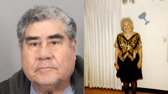
Man arrested in San Jose cold case murder of girlfriend
The boyfriend of a San Jose woman found dead in her home nearly 30 years ago has been arrested, potentially bringing a close to the cold case.
The boyfriend of a San Jose woman found dead in her home nearly 30 years ago has been arrested, potentially bringing a close to the cold case.


California loses $160M for delaying revocation of 17,000 commercial driver's licenses for immigrants
California will lose $160 million for delaying the revocations of 17,000 commercial driver's licenses for immigrants, federal transportation officials announced Wednesday.
California will lose $160 million for delaying the revocations of 17,000 commercial driver's licenses for immigrants, federal transportation officials announced Wednesday.


San Francisco immigration court building to close
The San Francisco immigration court building on Montgomery Street is set to close in January 2027.
The San Francisco immigration court building on Montgomery Street is set to close in January 2027.


San Francisco supervisors call for hearing into PG&E's massive blackout
San Francisco supervisors are calling for a hearing by the board into the massive power outage in the city last month.
San Francisco supervisors are calling for a hearing by the board into the massive power outage in the city last month.


Minneapolis ICE shooting: Woman killed by agent identified
Minneapolis officials on Wednesday afternoon said the woman who was fatally shot by an ICE official was a 37-year-old woman, Renee Nicole Good, who appeared to be in the vehicle alone.
Minneapolis officials on Wednesday afternoon said the woman who was fatally shot by an ICE official was a 37-year-old woman, Renee Nicole Good, who appeared to be in the vehicle alone.


Eerie surveillance video shows 'person of interest' in unsolved Ohio dentist murder case
Officials have released eerie surveillance footage capturing a "person of interest" in the unsolved murders of an Ohio dentist and his wife, who were gunned down inside their home.
Officials have released eerie surveillance footage capturing a "person of interest" in the unsolved murders of an Ohio dentist and his wife, who were gunned down inside their home.


Minneapolis mayor to ICE: 'Get the f*** out of Minneapolis'
Minneapolis Mayor Jacob Frey shared details about Wednesday's deadly shooting involving an ICE agent, and his message to immigration officials.
Minneapolis Mayor Jacob Frey shared details about Wednesday's deadly shooting involving an ICE agent, and his message to immigration officials.

Boyfriend arrested in 1997 San Jose cold case killing
The boyfriend of a San Jose woman found dead in her home nearly 30 years ago has been arrested, potentially bringing a close to the cold case.
The boyfriend of a San Jose woman found dead in her home nearly 30 years ago has been arrested, potentially bringing a close to the cold case.


Oakland mayor, city leaders tout lower crime rates in 2025
Oakland Police Chief James Beere said the 2025 homicide rate is a 22% decrease from 2024.
Oakland Police Chief James Beere said the 2025 homicide rate is a 22% decrease from 2024.


Valero powering down operations at Benicia refinery
Energy company Valero announced it will begin powering down operations at its refinery in Benicia, with plans to stop producing fuel in Northern California entirely by April.
Energy company Valero announced it will begin powering down operations at its refinery in Benicia, with plans to stop producing fuel in Northern California entirely by April.