

The Fog Fights Back: Marine Layer Expands Inland for the Holiday Weekend
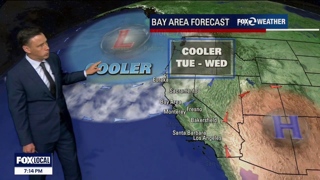
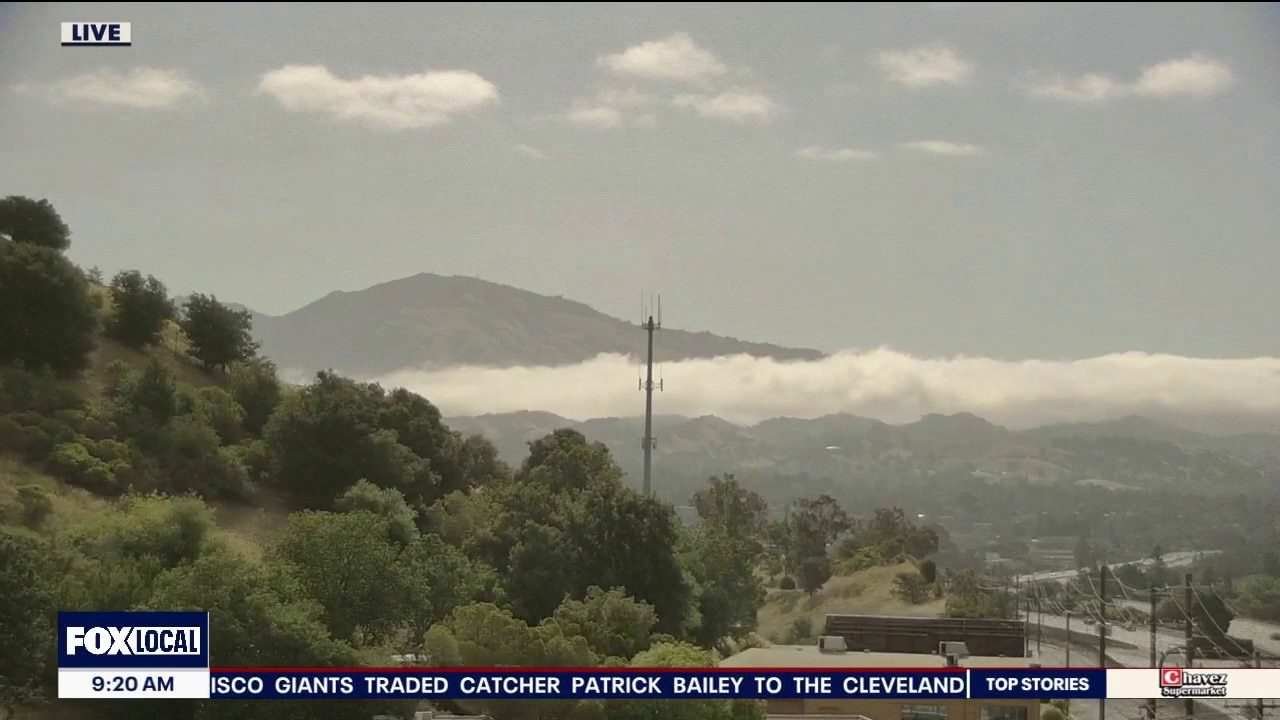
The weather tug-of-war is shifting and our natural air conditioning is gaining ground. The marine layer has deepened to around 1,000–1,500 feet, sending fingers of thick fog into the interior valleys. The Forecast: Day-by-Day Tonight: The fog is expanding. Stratus is already hugging the immediate coast, moving through the Golden Gate toward Berkeley. Expect a gray, souggy blanket to fill most inland valleys by early Friday morning . Friday Afternoon: Temperatures begin to drop across the board. The coast stays crisp in the upper 50s to low-60s, while inland valleys drop from the 90s back into the upper 70s and mid-80s. The Memorial Day Weekend: The marine layer deepens even further to 1,500 feet. Expect seasonal, comfortable temperatures alongside the threat of late-night and early-morning coastal drizzle.
The weather tug-of-war is shifting and our natural air conditioning is gaining ground. The marine layer has deepened to around 1,000–1,500 feet, sending fingers of thick fog into the interior valleys. The Forecast: Day-by-Day Tonight: The fog is expanding. Stratus is already hugging the immediate coast, moving through the Golden Gate toward Berkeley. Expect a gray, souggy blanket to fill most inland valleys by early Friday morning . Friday Afternoon: Temperatures begin to drop across the board. The coast stays crisp in the upper 50s to low-60s, while inland valleys drop from the 90s back into the upper 70s and mid-80s. The Memorial Day Weekend: The marine layer deepens even further to 1,500 feet. Expect seasonal, comfortable temperatures alongside the threat of late-night and early-morning coastal drizzle.
Another hot forecast inland
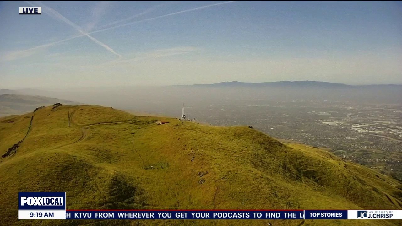
The Bay Area microclimates are resurfacing. Patchy fog will return and will keep coastal neighborhoods in the cool 60s. We are expecting another round of hot temperatures inland. The entire Bay Area will be cooling over the weekend.
The Bay Area microclimates are resurfacing. Patchy fog will return and will keep coastal neighborhoods in the cool 60s. We are expecting another round of hot temperatures inland. The entire Bay Area will be cooling over the weekend.
Warmer forecast
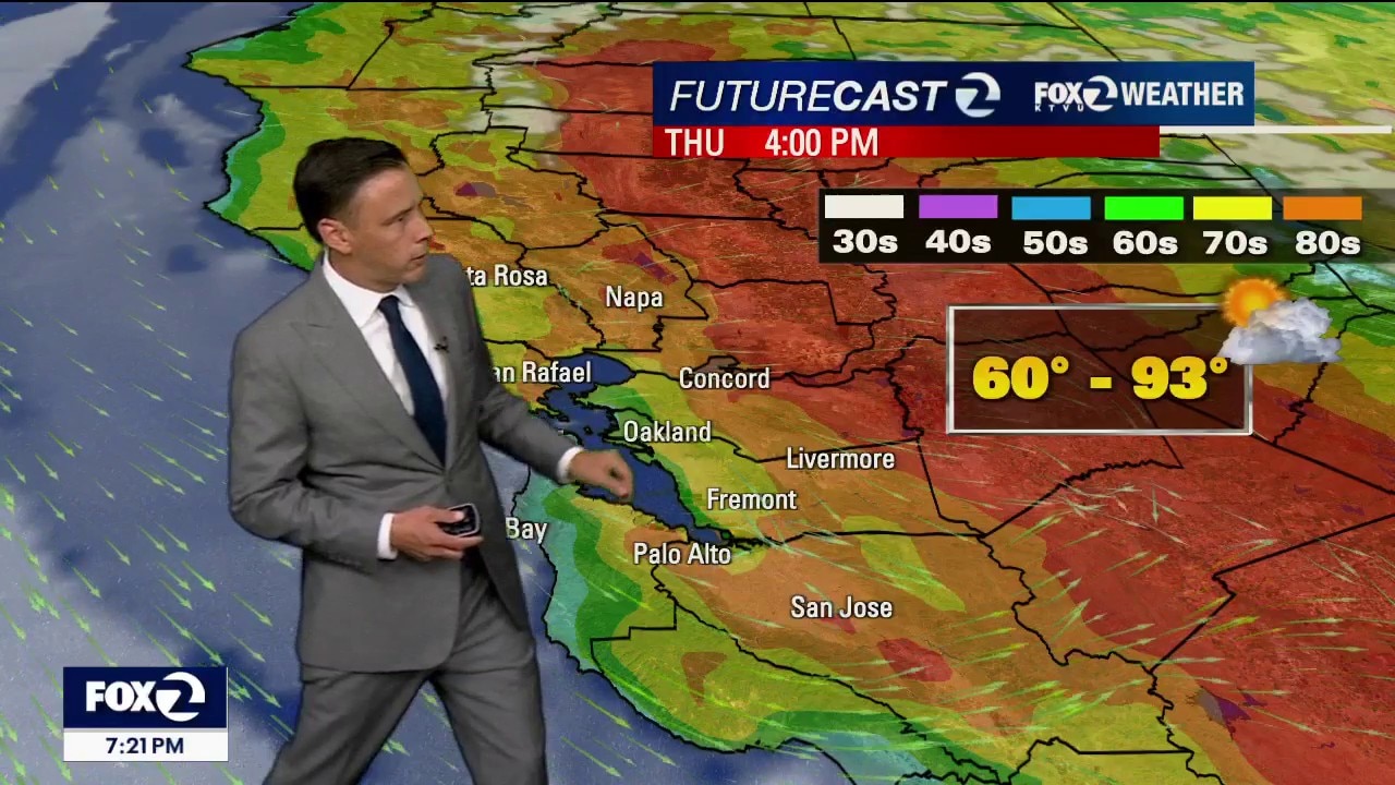
Your Tuesday forecast features mostly sunny skies and warmer temperatures. Highs should range from the low 70s near the coast to the low 90s inland. The warm to hot pattern remains in place through Thursday, Temperatures will be cooling over the holiday weekend.
Your Tuesday forecast features mostly sunny skies and warmer temperatures. Highs should range from the low 70s near the coast to the low 90s inland. The warm to hot pattern remains in place through Thursday, Temperatures will be cooling over the holiday weekend.

Warmer forecast
Your Tuesday forecast features mostly sunny skies and warmer temperatures. Highs should range from the low 70s near the coast to the low 90s inland. The warm to hot pattern remains in place through Thursday, Temperatures will be cooling over the the holiday weekend.
Your Tuesday forecast features mostly sunny skies and warmer temperatures. Highs should range from the low 70s near the coast to the low 90s inland. The warm to hot pattern remains in place through Thursday, Temperatures will be cooling over the the holiday weekend.
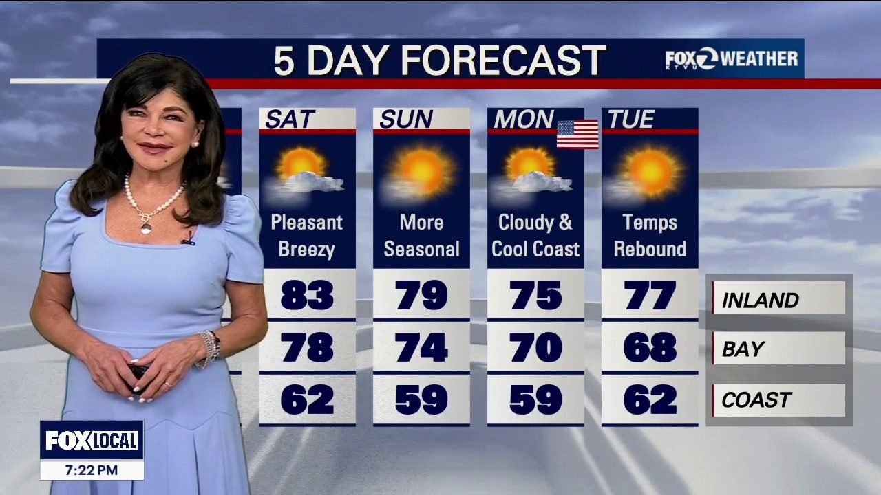
Warmer Monday
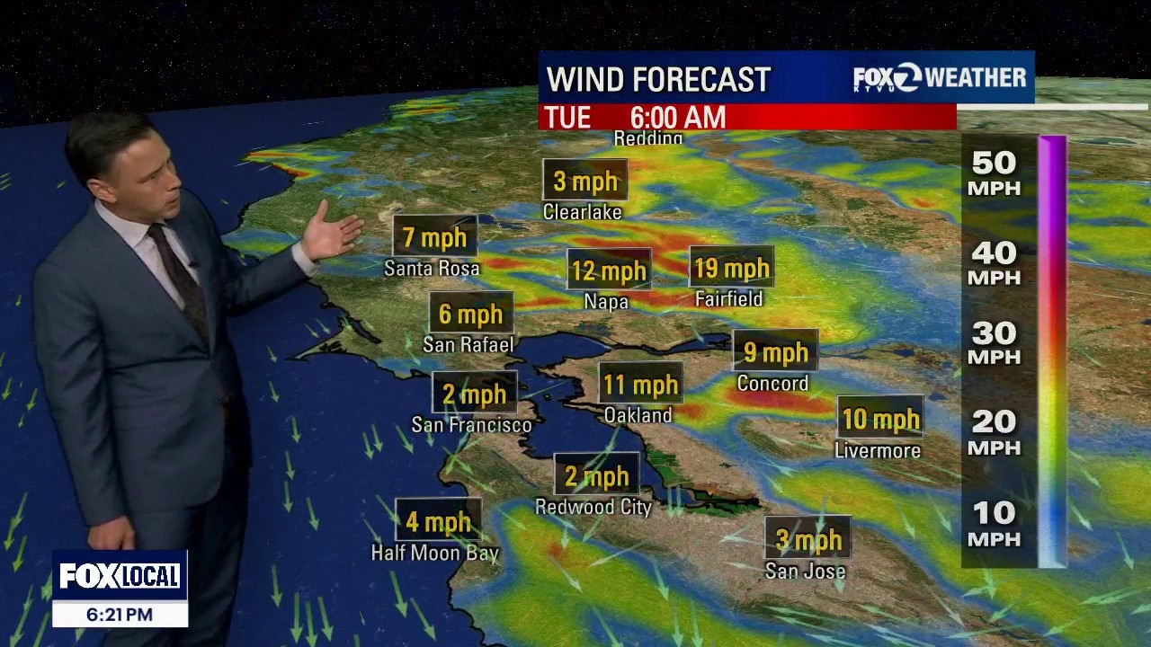
The breezy windy pattern remains in place. Gusts could approach 50 mph in the Bay Area Hills Monday morning. The Monday forecast also features warmer temperatures. Highs should range from the low 70s to the upper 80s. The warm to hot stretch will highlight our forecast this week. Inland spots will warm into the low 90s. We will also be monitoring the fire danger.
The breezy windy pattern remains in place. Gusts could approach 50 mph in the Bay Area Hills Monday morning. The Monday forecast also features warmer temperatures. Highs should range from the low 70s to the upper 80s. The warm to hot stretch will highlight our forecast this week. Inland spots will warm into the low 90s. We will also be monitoring the fire danger.
Another beautiful day, but concerns remain
Spectacular temperatures in store for most today. However, we are not worry free. A Red Flag Warning continues in Solano County for dry, breezy conditions. A Wind Advisory is expected for Bay Area hills starting at 11pm tonight. A Coastal Flood Advisory for North Bay low lying areas. Closer to the shore, Hazardous conditions continue along our coast with an increased risk of sneaker waves and rip currents lasting until tomorrow morning.
Spectacular temperatures in store for most today. However, we are not worry free. A Red Flag Warning continues in Solano County for dry, breezy conditions. A Wind Advisory is expected for Bay Area hills starting at 11pm tonight. A Coastal Flood Advisory for North Bay low lying areas. Closer to the shore, Hazardous conditions continue along our coast with an increased risk of sneaker waves and rip currents lasting until tomorrow morning.
Wind whipped weather creating hazardous conditions today
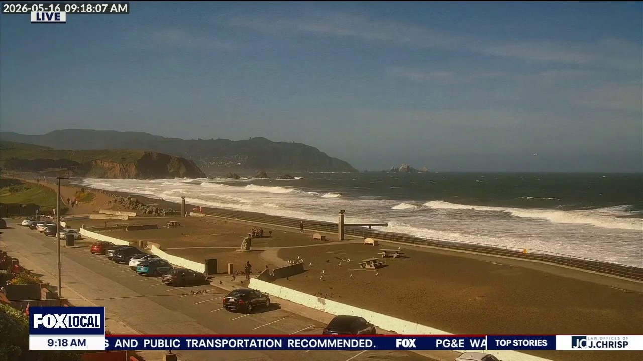
Breezy to windy weather will continue through the weekend, especially along the coast where gusts could reach 40 - 50 mph. A Wind Advisory is in effect for coastal areas through early Sunday morning (excluding Santa Cruz). Beach conditions will also be hazardous through Monday morning due to strong winds and surf. Fire weather concerns remain elevated through Monday with a Red Flag Warning for Solano County.
Breezy to windy weather will continue through the weekend, especially along the coast where gusts could reach 40 - 50 mph. A Wind Advisory is in effect for coastal areas through early Sunday morning (excluding Santa Cruz). Beach conditions will also be hazardous through Monday morning due to strong winds and surf. Fire weather concerns remain elevated through Monday with a Red Flag Warning for Solano County.
"Weekend Weather Danger: High Fire Risks Inland, Turbulent Conditions at the Coast
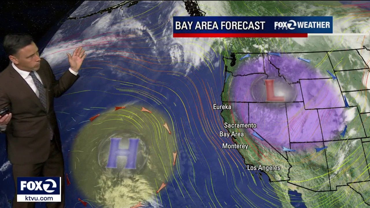
A dry "inside slider" is dropping south from the Pacific Northwest tightening pressure gradients. This setup has triggered a Red Flag Warning for Solano County Saturday - Monday. Winds: North winds will track 20 - 30 mph with gusts 35 to 45 mph (and up to 50 mph around the Delta gap). Any fire that sparks this weekend will grow and spread rapidly. High temps 60s to low 80s. Outdoor burning is strictly discouraged and drivers should avoid parking vehicles on dry grass. A Beach Hazards Statement for dangerous coastal conditions through Monday. Special Warning: Bay to Breakers participants to completely stay out of the water at Ocean Beach this weekend. High tidal swings could also trap walkers against the cliffs. Stay off the rocks and jetties! Coastal Flood Advisory 10 PM SATURDAY - 3 AM TUESDAY. WHAT: Up to 1.0 ft of inundation above ground level is possible in low-lying areas near shorelines and tidal waterways. WHERE: Bayshore locations along the San Pablo Bay. WHEN: From 10 PM Saturday to 3 AM Tuesday.
A dry "inside slider" is dropping south from the Pacific Northwest tightening pressure gradients. This setup has triggered a Red Flag Warning for Solano County Saturday - Monday. Winds: North winds will track 20 - 30 mph with gusts 35 to 45 mph (and up to 50 mph around the Delta gap). Any fire that sparks this weekend will grow and spread rapidly. High temps 60s to low 80s. Outdoor burning is strictly discouraged and drivers should avoid parking vehicles on dry grass. A Beach Hazards Statement for dangerous coastal conditions through Monday. Special Warning: Bay to Breakers participants to completely stay out of the water at Ocean Beach this weekend. High tidal swings could also trap walkers against the cliffs. Stay off the rocks and jetties! Coastal Flood Advisory 10 PM SATURDAY - 3 AM TUESDAY. WHAT: Up to 1.0 ft of inundation above ground level is possible in low-lying areas near shorelines and tidal waterways. WHERE: Bayshore locations along the San Pablo Bay. WHEN: From 10 PM Saturday to 3 AM Tuesday.
Stronger winds
More sunshine in your Friday forecast. The mild to warm pattern remains in place. Highs should range from mid 60s to the mid 80s. We expecting stronger winds in the weekend forecast. Gusts could approach 50 mph in parts of the Bay Area. The dry wind will also boost fire danger. A Fire Weather Watch has been issued for parts of Northern California (including Solano County).
More sunshine in your Friday forecast. The mild to warm pattern remains in place. Highs should range from mid 60s to the mid 80s. We expecting stronger winds in the weekend forecast. Gusts could approach 50 mph in parts of the Bay Area. The dry wind will also boost fire danger. A Fire Weather Watch has been issued for parts of Northern California (including Solano County).
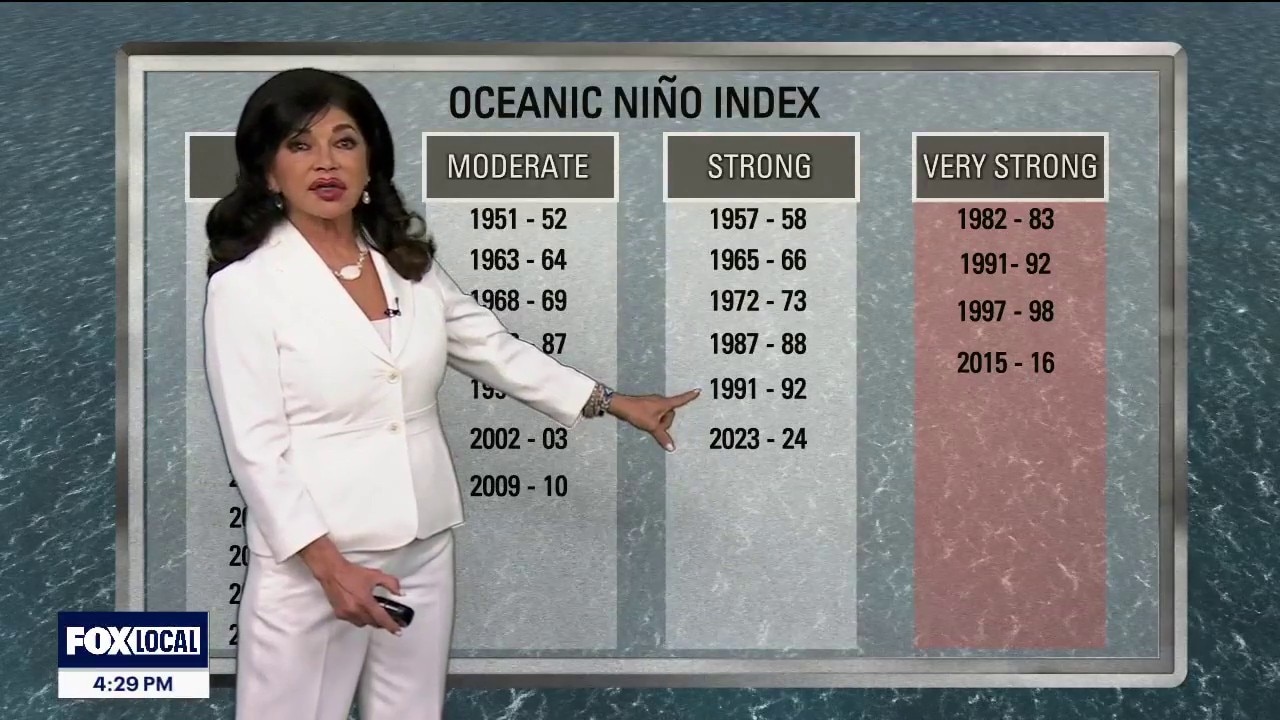
The KTVU Weather Department talks about El Nino and the Bay Area
An El Niño event has an 82% probability of developing by July 2026 and a 96% chance of lasting through the Northern Hemisphere winter, with potential for a "super" El Niño. This pattern is expected to suppress Atlantic hurricane activity while increasing global temperature records and enhancing precipitation in the southern U.S
An El Niño event has an 82% probability of developing by July 2026 and a 96% chance of lasting through the Northern Hemisphere winter, with potential for a "super" El Niño. This pattern is expected to suppress Atlantic hurricane activity while increasing global temperature records and enhancing precipitation in the southern U.S
Gorgeous today, winds crank up Friday throught the weekend
Today: Sunny & Warm Enjoy a beautiful spring afternoon! Temperatures are warming up into the 60s and 70s near the coast and the 80s to near 90 inland. Tonight: Skies will stay mostly clear and dry, with only a small chance of patchy fog right at the coast. Few 40s, mainly overnight temps in the 50s. Friday & Weekend: The calm weather ends tomorrow as a strong wind machine turns on. Sunny skies with cooler temperatures. West winds increase 20 - 30 mph with the potential of a Wind Advisory for the weekend. Hazardous Seas: Very strong winds over the ocean will create dangerous marine conditions starting Friday. Boaters and swimmers should use extreme caution. Gusty Land Winds: Expect a big jump in winds along the immediate coast and up in the mountains through the weekend. Elevated Fire Warning (Weekend through Monday) The Dry Out: A very dry air mass is moving in. Humidity levels are going to plummet during each day and will stay unusually low at night.
Today: Sunny & Warm Enjoy a beautiful spring afternoon! Temperatures are warming up into the 60s and 70s near the coast and the 80s to near 90 inland. Tonight: Skies will stay mostly clear and dry, with only a small chance of patchy fog right at the coast. Few 40s, mainly overnight temps in the 50s. Friday & Weekend: The calm weather ends tomorrow as a strong wind machine turns on. Sunny skies with cooler temperatures. West winds increase 20 - 30 mph with the potential of a Wind Advisory for the weekend. Hazardous Seas: Very strong winds over the ocean will create dangerous marine conditions starting Friday. Boaters and swimmers should use extreme caution. Gusty Land Winds: Expect a big jump in winds along the immediate coast and up in the mountains through the weekend. Elevated Fire Warning (Weekend through Monday) The Dry Out: A very dry air mass is moving in. Humidity levels are going to plummet during each day and will stay unusually low at night.
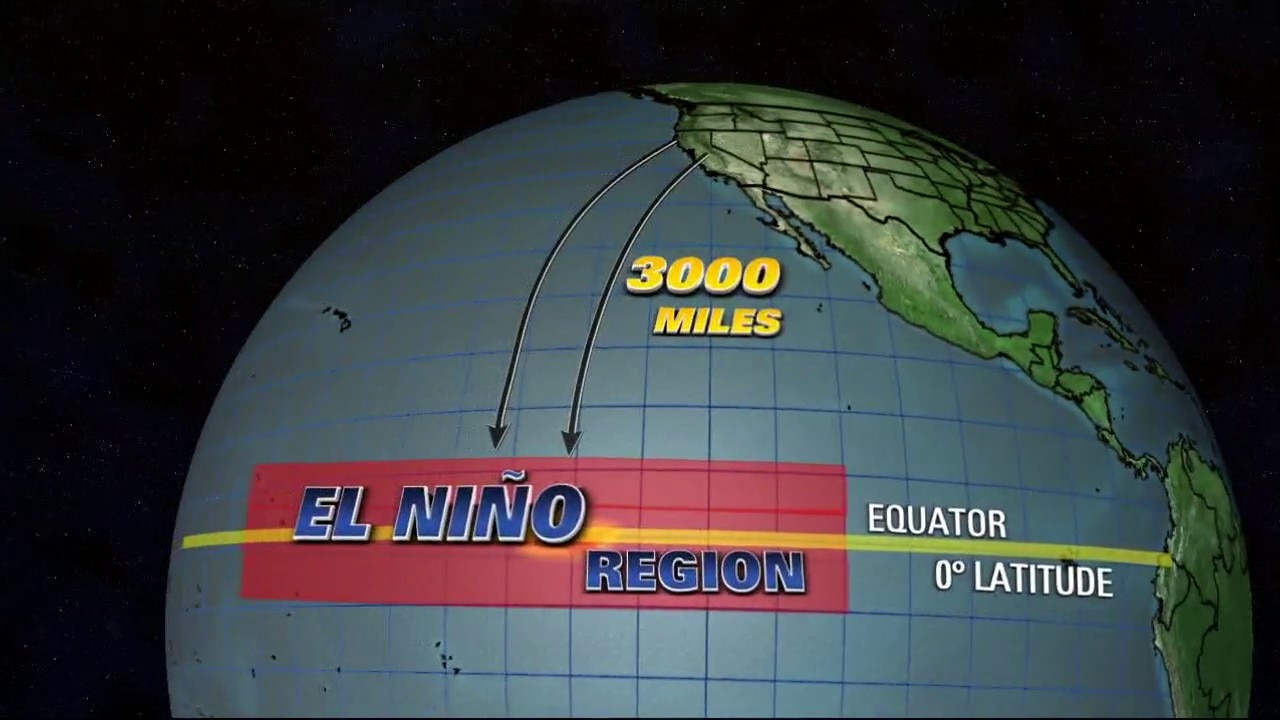
El Niño Explainer: Conditions return this year
El Niño is a natural recurring climate pattern that has its origins in the Pacific Ocean. The pattern will return this year as conditions change. KTVU Chief Meteorologist dives in on what this means.
El Niño is a natural recurring climate pattern that has its origins in the Pacific Ocean. The pattern will return this year as conditions change. KTVU Chief Meteorologist dives in on what this means.
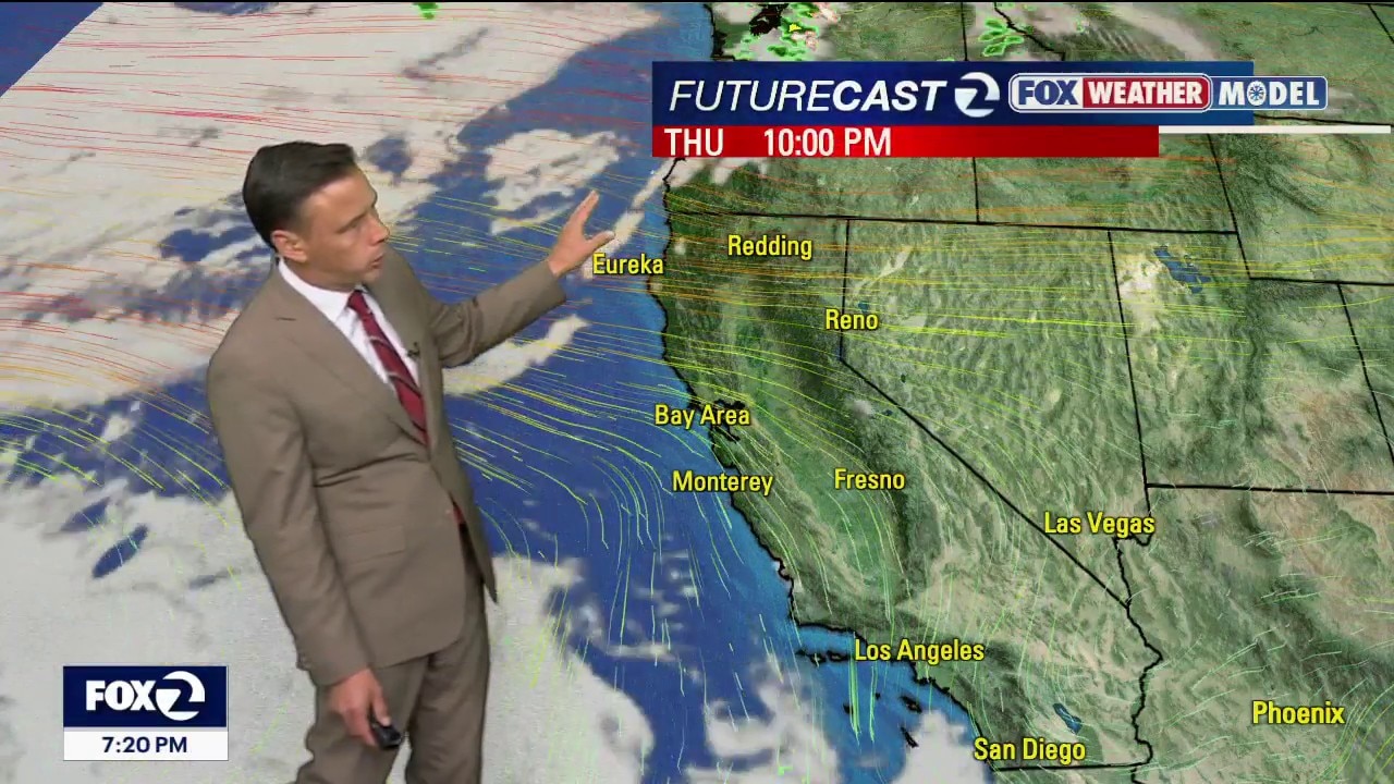
Warmer weather blowing this way
Thursday: Warming day. Inland valleys jump into the upper 70s to upper 80s. Coastal areas stay cool in the upper 50s to lower 60s. Friday: Inland temperatures hold steady in the 80s. Coastal zones begin cooling as onshore flow increases. Saturday & Sunday: The incoming trough drops inland temperatures back down to the 70s and low 80s. Weekend Peak: Extreme northwesterly gusts will exceed 40 mph on Saturday. Impact Areas: High confidence for damaging gusts along the coast, the Salinas Valley, and the Mayacama, Santa Cruz, and Santa Lucia mountains. Marine Alert: Expect Wind Advisories, Beach Hazards Statements, or High Surf Advisories due to dangerous, wind-driven waves.
Thursday: Warming day. Inland valleys jump into the upper 70s to upper 80s. Coastal areas stay cool in the upper 50s to lower 60s. Friday: Inland temperatures hold steady in the 80s. Coastal zones begin cooling as onshore flow increases. Saturday & Sunday: The incoming trough drops inland temperatures back down to the 70s and low 80s. Weekend Peak: Extreme northwesterly gusts will exceed 40 mph on Saturday. Impact Areas: High confidence for damaging gusts along the coast, the Salinas Valley, and the Mayacama, Santa Cruz, and Santa Lucia mountains. Marine Alert: Expect Wind Advisories, Beach Hazards Statements, or High Surf Advisories due to dangerous, wind-driven waves.
Stronger winds Wednesday
A system will clip Northern California Wednesday. After some clouds in the morning, sunshine returns during the afternoon. Highs should range from the upper 50s to the upper 70s. Winds will be increasing. Gusts could approach 40 mph.
A system will clip Northern California Wednesday. After some clouds in the morning, sunshine returns during the afternoon. Highs should range from the upper 50s to the upper 70s. Winds will be increasing. Gusts could approach 40 mph.
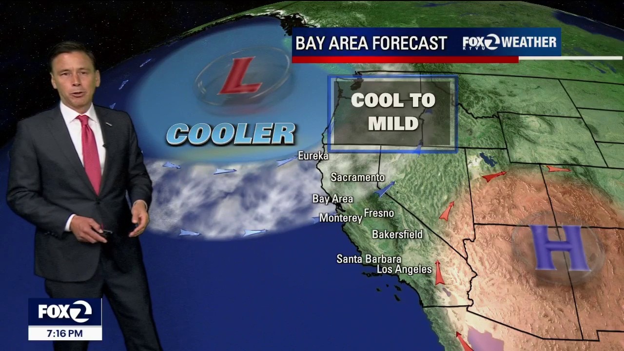
Cooler pattern
A cooler weather pattern will pay us a visit over the next couple of days. Low clouds and fog will resurface Tuesday morning. Partly sunny skies are expected later in the day. Highs should range from the low 60s to the low 80s. Winds will be increasing throughout the day. Gusts could exceed 30 mph.
A cooler weather pattern will pay us a visit over the next couple of days. Low clouds and fog will resurface Tuesday morning. Partly sunny skies are expected later in the day. Highs should range from the low 60s to the low 80s. Winds will be increasing throughout the day. Gusts could exceed 30 mph.
Mild coast, warm bay, hot inland today
Today will be the warmest of our current trend. Partly cloudy skies can be expected for the afternoon with temperatures ranging from upper 60s along the shore, 70s around the bay and 80s - 90s inland. A drop in afternoon highs in the forecast for tomorrow.
Today will be the warmest of our current trend. Partly cloudy skies can be expected for the afternoon with temperatures ranging from upper 60s along the shore, 70s around the bay and 80s - 90s inland. A drop in afternoon highs in the forecast for tomorrow.
One day summer sizzle
Looking ahead: We are in a tug-of-war between high pressure trying to heat things up and the "marine layer" (our coastal fog) trying to keep us cool. While Monday is still technically the warmest day of the week, the ocean air is winning more battles than expected, keeping temperatures a bit lower than original "heatwave" predictions. Monday Forecast: The Warmest Day The Forecast: It’s a "tricky" one. If the clouds clear out early, inland areas will reach the mid-80s to low 90s. However, if the fog lingers like it did today, we could stay several degrees cooler. The Coast: Expect much cooler conditions in the 60s and 70s thanks to a persistent ocean breeze and shallow fog. Heat Risk: The risk of heat-related illness is now less widespread than previously thought, but it will still feel quite toasty in the far interior valleys.
Looking ahead: We are in a tug-of-war between high pressure trying to heat things up and the "marine layer" (our coastal fog) trying to keep us cool. While Monday is still technically the warmest day of the week, the ocean air is winning more battles than expected, keeping temperatures a bit lower than original "heatwave" predictions. Monday Forecast: The Warmest Day The Forecast: It’s a "tricky" one. If the clouds clear out early, inland areas will reach the mid-80s to low 90s. However, if the fog lingers like it did today, we could stay several degrees cooler. The Coast: Expect much cooler conditions in the 60s and 70s thanks to a persistent ocean breeze and shallow fog. Heat Risk: The risk of heat-related illness is now less widespread than previously thought, but it will still feel quite toasty in the far interior valleys.
Mother Nature bringing a mixed bag for Mother' s Day
After a mostly cloudy, drizzly start to the day, partly cloudy to mostly sunny conditions can be expected by afternoon for Mother's Day Sunday. Afternoon highs will range from low 60s near the coast to mid 80s inland. The warming trend will peak on Monday when inland cities soar into the low 90s.
After a mostly cloudy, drizzly start to the day, partly cloudy to mostly sunny conditions can be expected by afternoon for Mother's Day Sunday. Afternoon highs will range from low 60s near the coast to mid 80s inland. The warming trend will peak on Monday when inland cities soar into the low 90s.

Mother Nature bring a mixed bag for Mother' s Day
Partly cloudy to mostly sunny conditions can be expected for Mother's Day Sunday. Afternoon highs will range from low 60s near the coast to mid 80s inland. The warming trend will peak on Monday
Partly cloudy to mostly sunny conditions can be expected for Mother's Day Sunday. Afternoon highs will range from low 60s near the coast to mid 80s inland. The warming trend will peak on Monday
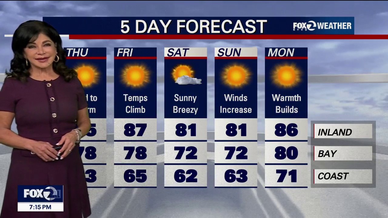
"May Gray" AND sunshine for Mother's Day
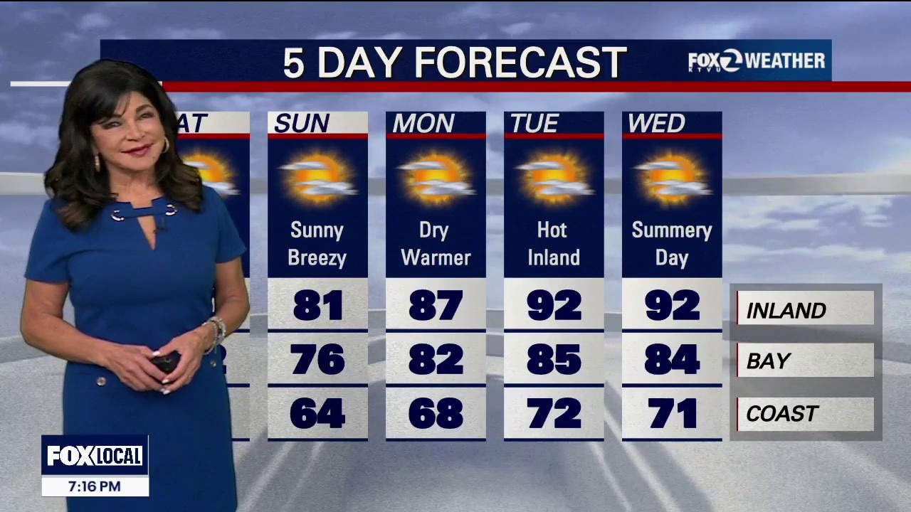
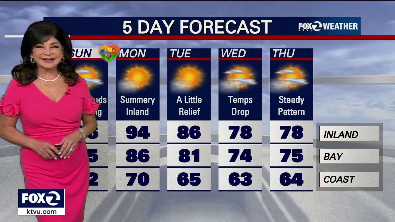
Saturday Evening & Sunday: Heating Up Tonight: Expect the "May Gray" to return as coastal fog and low clouds push into the valleys overnight. You might even see some mist or light drizzle by Sunday morning. Sunday: Clouds will clear out quickly in the morning, giving way to plenty of sunshine. Highs will be a little warmer than Saturday, reaching the mid-80s to low 90s in far inland spots, while the coast stays refreshed in the upper 50s and 60s. Monday: The Peak Heat Monday will be the hottest day of the week across the region. Temperature Ranges: Interior Valleys: Low to upper 90s. Inland Areas: Mid-80s to low 90s. Near the Coast: Low 70s to mid-80s. Heat Risk: Much of the interior is under a Moderate Heat Risk. This can be dangerous for people sensitive to heat, like children, the elderly or those working outdoors. The heat won't last long. Starting Tuesday, temps begin to dip, though they will still be warmer than average for this time of year. Big Shift: Chance of drizzle or light rain midweek!
Saturday Evening & Sunday: Heating Up Tonight: Expect the "May Gray" to return as coastal fog and low clouds push into the valleys overnight. You might even see some mist or light drizzle by Sunday morning. Sunday: Clouds will clear out quickly in the morning, giving way to plenty of sunshine. Highs will be a little warmer than Saturday, reaching the mid-80s to low 90s in far inland spots, while the coast stays refreshed in the upper 50s and 60s. Monday: The Peak Heat Monday will be the hottest day of the week across the region. Temperature Ranges: Interior Valleys: Low to upper 90s. Inland Areas: Mid-80s to low 90s. Near the Coast: Low 70s to mid-80s. Heat Risk: Much of the interior is under a Moderate Heat Risk. This can be dangerous for people sensitive to heat, like children, the elderly or those working outdoors. The heat won't last long. Starting Tuesday, temps begin to dip, though they will still be warmer than average for this time of year. Big Shift: Chance of drizzle or light rain midweek!