


Inside Oakland's Bake Sum Bakery
Joyce Tang pivoted to a pop-up called “Bake Sum,” serving creative Asian American treats that quickly built a devoted following across the east bay. Now, six years later, Oakland's Bake Sum has earned national buzz, a “best bakery in the east bay” title from nosh readers, a brand-new cookbook — and a second east bay location. Joyce Tang, owner of Bake Sum, shares here story.
Joyce Tang pivoted to a pop-up called “Bake Sum,” serving creative Asian American treats that quickly built a devoted following across the east bay. Now, six years later, Oakland's Bake Sum has earned national buzz, a “best bakery in the east bay” title from nosh readers, a brand-new cookbook — and a second east bay location. Joyce Tang, owner of Bake Sum, shares here story.

San Francisco's free Cultural Festival in Chinatown
On May 31, San Francisco‘s Chinatown will host an event celebrating the vibrant culture, tasty food, and lively performances that make Chinatown so special. Nancy Yu, event director gives insight.
On May 31, San Francisco‘s Chinatown will host an event celebrating the vibrant culture, tasty food, and lively performances that make Chinatown so special. Nancy Yu, event director gives insight.
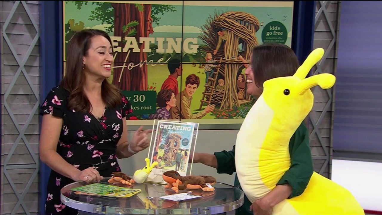
Filoli Launches “Kids Go Free” Promo for Summer
Starting May 30, children ages 0–14 get in FREE with every full-price adult ticket. Sonia Capitant, associate director of community programs and partnerships with Filoli Gardens, gives insight.
Starting May 30, children ages 0–14 get in FREE with every full-price adult ticket. Sonia Capitant, associate director of community programs and partnerships with Filoli Gardens, gives insight.
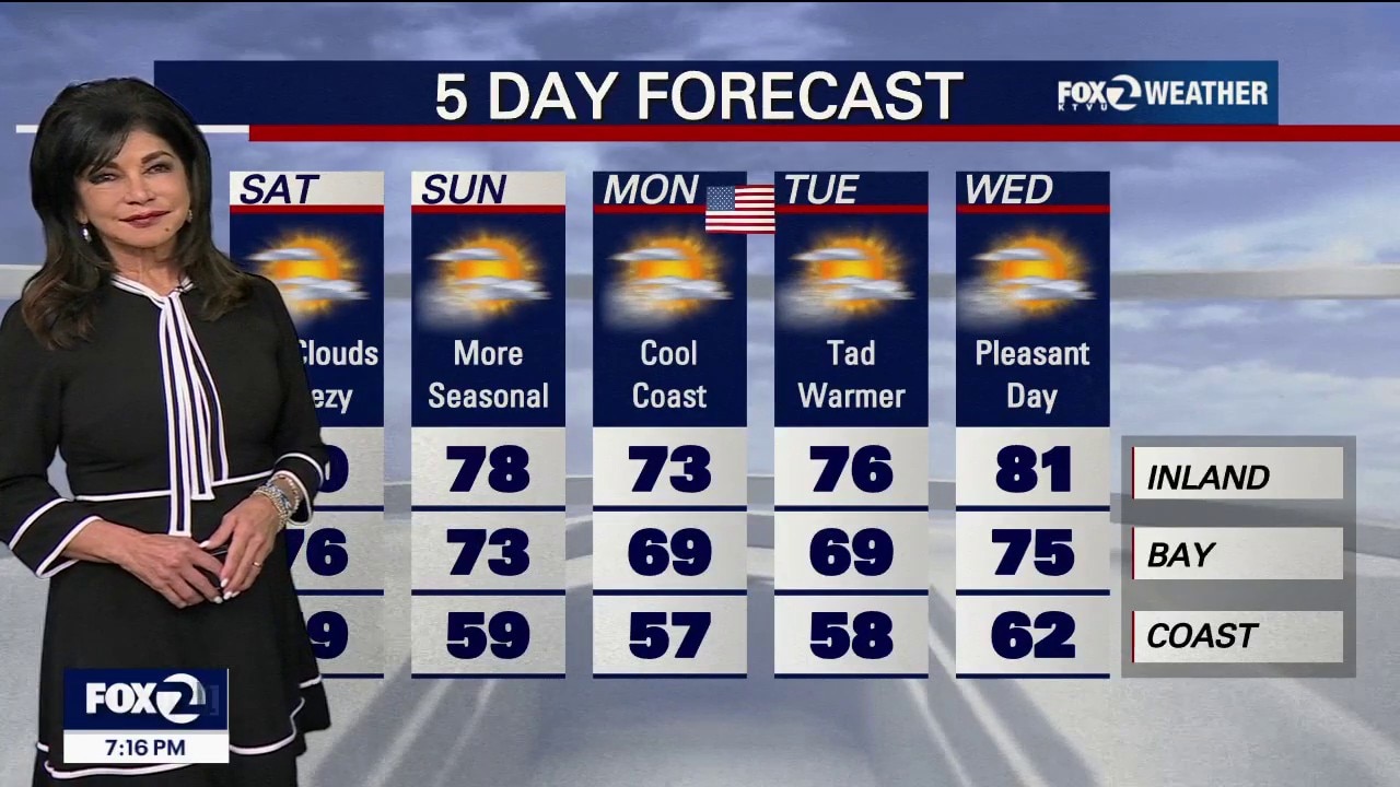
Holiday Cool-Down: Widespread Fog Floods the Bay for Memorial Day Weekend
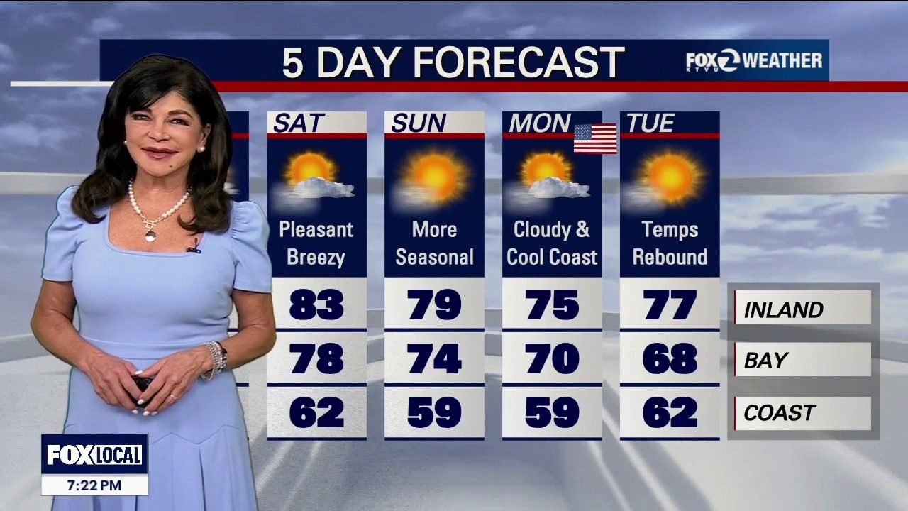
Tonight: The fog is moving fast. Thick low clouds are currently spilling through the Petaluma Gap, the Golden Gate, and across the Monterey Bay region. Only the highest mountain peaks and the far eastern edge of Contra Costa County will escape the gray blanket by morning. Saturday & Sunday: Expect a gray start to the holiday weekend. Low clouds will be slow to clear each morning, keeping afternoon temperatures very seasonal. Expect upper 50s to mid-60s on the coast, 60s to low 70s around the Bay, and upper 70s to mid-80s far inland. Patchy coastal drizzle is possible both nights. Memorial Day Monday: We start mild, but a cold front approaches late in the day, cranking up the afternoon ocean breezes. No Coastal clearing in the 50s, unseasonably cool Inland in the low to mid 70s. Breezy. Tuesday: The cold front sweeps through from north to south. It will bring much cooler temperatures and a round of widespread drizzle or light rain to the Bay Area and Central Coast. Enjoy your holiday weekend, but be safe!
Tonight: The fog is moving fast. Thick low clouds are currently spilling through the Petaluma Gap, the Golden Gate, and across the Monterey Bay region. Only the highest mountain peaks and the far eastern edge of Contra Costa County will escape the gray blanket by morning. Saturday & Sunday: Expect a gray start to the holiday weekend. Low clouds will be slow to clear each morning, keeping afternoon temperatures very seasonal. Expect upper 50s to mid-60s on the coast, 60s to low 70s around the Bay, and upper 70s to mid-80s far inland. Patchy coastal drizzle is possible both nights. Memorial Day Monday: We start mild, but a cold front approaches late in the day, cranking up the afternoon ocean breezes. No Coastal clearing in the 50s, unseasonably cool Inland in the low to mid 70s. Breezy. Tuesday: The cold front sweeps through from north to south. It will bring much cooler temperatures and a round of widespread drizzle or light rain to the Bay Area and Central Coast. Enjoy your holiday weekend, but be safe!


Women file class-action lawsuit over SF jail strip searches
Twenty women who say they were subjected to degrading strip searches as San Francisco jail inmates while male deputies were nearby — filed a civil rights lawsuit Friday, a year after the incident.
Twenty women who say they were subjected to degrading strip searches as San Francisco jail inmates while male deputies were nearby — filed a civil rights lawsuit Friday, a year after the incident.


Murder charges filed in 2024 killing of wheelchair-bound man in Mission District
A man accused of fatally shooting a wheelchair-bound man in San Francisco’s Mission District nearly two years ago has been charged with murder, authorities said Friday.
A man accused of fatally shooting a wheelchair-bound man in San Francisco’s Mission District nearly two years ago has been charged with murder, authorities said Friday.
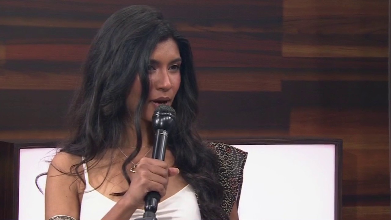
Fijiana’s global moment, the artist behind “Welcome to the Bay”
From Richmond to international stages, Fijiana blends Indo-Fijian roots with Bay Area hip-hop. For AAPI Heritage Month, the rising artist reflects on immigration, identity and using music to advocate for her community as her career continues to grow.
From Richmond to international stages, Fijiana blends Indo-Fijian roots with Bay Area hip-hop. For AAPI Heritage Month, the rising artist reflects on immigration, identity and using music to advocate for her community as her career continues to grow.

Mind games: Silicon Valley father and son duo
They’ve amazed audiences from Silicon Valley to live television, now this father-son duo brings their modern mentalism live to our studio. As part of AAPI Heritage Month, we explore how Dan and James Chan are transforming traditional magic into something psychological, and completely unforgettable.
They’ve amazed audiences from Silicon Valley to live television, now this father-son duo brings their modern mentalism live to our studio. As part of AAPI Heritage Month, we explore how Dan and James Chan are transforming traditional magic into something psychological, and completely unforgettable.

Oakland comic book sparks mental health conversations
May is Mental Health Awareness Month and one Oakland screenwriter and author is using comic books to spark important conversations about trauma, grief and healing.
May is Mental Health Awareness Month and one Oakland screenwriter and author is using comic books to spark important conversations about trauma, grief and healing.

BottleRock, Carnaval: Bay Area events on Memorial Day weekend
The Bay Area is shaping up to be warm and sunny this Memorial Day weekend, offering residents and visitors plenty of outdoor options stretching from San Francisco to the North Bay.
The Bay Area is shaping up to be warm and sunny this Memorial Day weekend, offering residents and visitors plenty of outdoor options stretching from San Francisco to the North Bay.


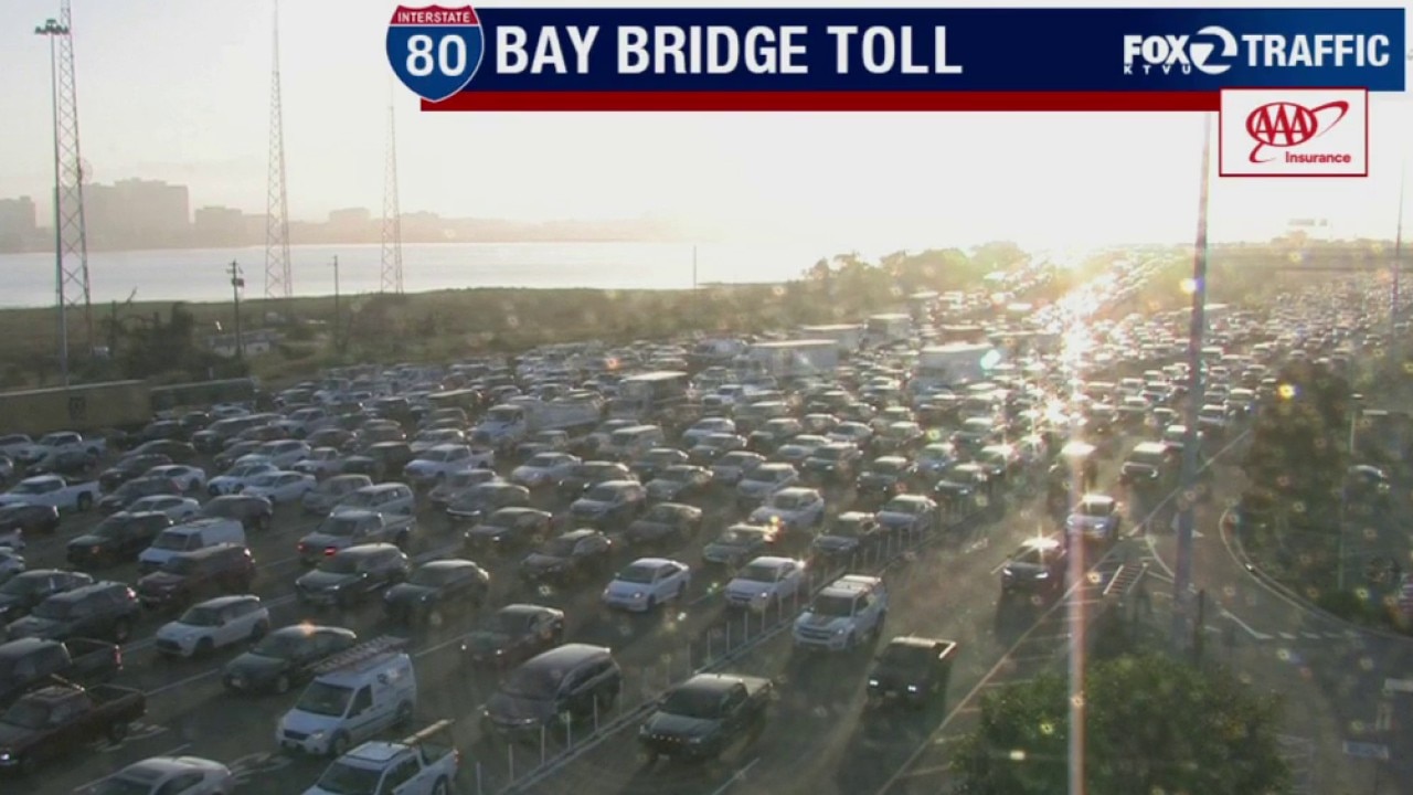
Final 19th Avenue closure in San Francisco on Memorial Day weekend
Drivers in San Francisco should brace for more delays this weekend as the third and final planned closure of 19th Avenue begins Friday morning.
Drivers in San Francisco should brace for more delays this weekend as the third and final planned closure of 19th Avenue begins Friday morning.
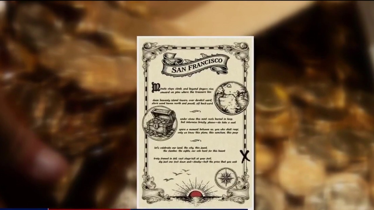
Buried treasure with $10,000 found in Marin Headlands
The hunt for buried treasure in the Bay Area has officially come to an end, wrapping up with an unexpected twist.
The hunt for buried treasure in the Bay Area has officially come to an end, wrapping up with an unexpected twist.


Iconic Castro legacy store Cliff's Variety to celebrate 90 years
A beloved San Francisco institution is preparing to celebrate nearly a century of business in the Castro. Cliff's Variety, the neighborhood staple known for everything from kitchenware and tools to disco balls and drag ensembles, will officially mark 90 years of business next month.
A beloved San Francisco institution is preparing to celebrate nearly a century of business in the Castro. Cliff's Variety, the neighborhood staple known for everything from kitchenware and tools to disco balls and drag ensembles, will officially mark 90 years of business next month.


Mother and son graduate together at SF State
Among this year's graduating class at SF State are a mother and her son.
Among this year's graduating class at SF State are a mother and her son.

San Francisco: Flamenco Arts International presents 'Songs From A Sinking Ship'
Flamenco Arts International is bringing back Songs from a Sinking Ship this weekend, a production that combines traditional flamenco with theatrical elements and multimedia design. The flamenco voyage on Saturday, May 23, at the Presidio Theatre, features Marina Elana, Carlos Menchaca, David Chupete, and living legend El Torombo.
Flamenco Arts International is bringing back Songs from a Sinking Ship this weekend, a production that combines traditional flamenco with theatrical elements and multimedia design. The flamenco voyage on Saturday, May 23, at the Presidio Theatre, features Marina Elana, Carlos Menchaca, David Chupete, and living legend El Torombo.

How AI Is Changing Vacation Planning
According to recently released data, more people are trusting AI to help them find travel deals. Greg Oates, director of AI Advocacy for GuideGeek, gives insight.
According to recently released data, more people are trusting AI to help them find travel deals. Greg Oates, director of AI Advocacy for GuideGeek, gives insight.

Sunnyvale massive food delivery
One truck. Millions of meals. A coordinated push across California, see how JustServe and local nonprofits are moving food and hope into communities facing rising food insecurity. : Marie Bernard, executive director of Sunnyvale Community Services, gives insight.
One truck. Millions of meals. A coordinated push across California, see how JustServe and local nonprofits are moving food and hope into communities facing rising food insecurity. : Marie Bernard, executive director of Sunnyvale Community Services, gives insight.
The Fog Fights Back: Marine Layer Expands Inland for the Holiday Weekend
The weather tug-of-war is shifting and our natural air conditioning is gaining ground. The marine layer has deepened to around 1,000–1,500 feet, sending fingers of thick fog into the interior valleys. The Forecast: Day-by-Day Tonight: The fog is expanding. Stratus is already hugging the immediate coast, moving through the Golden Gate toward Berkeley. Expect a gray, souggy blanket to fill most inland valleys by early Friday morning . Friday Afternoon: Temperatures begin to drop across the board. The coast stays crisp in the upper 50s to low-60s, while inland valleys drop from the 90s back into the upper 70s and mid-80s. The Memorial Day Weekend: The marine layer deepens even further to 1,500 feet. Expect seasonal, comfortable temperatures alongside the threat of late-night and early-morning coastal drizzle.
The weather tug-of-war is shifting and our natural air conditioning is gaining ground. The marine layer has deepened to around 1,000–1,500 feet, sending fingers of thick fog into the interior valleys. The Forecast: Day-by-Day Tonight: The fog is expanding. Stratus is already hugging the immediate coast, moving through the Golden Gate toward Berkeley. Expect a gray, souggy blanket to fill most inland valleys by early Friday morning . Friday Afternoon: Temperatures begin to drop across the board. The coast stays crisp in the upper 50s to low-60s, while inland valleys drop from the 90s back into the upper 70s and mid-80s. The Memorial Day Weekend: The marine layer deepens even further to 1,500 feet. Expect seasonal, comfortable temperatures alongside the threat of late-night and early-morning coastal drizzle.


San Francisco Symphony appoints Elim Chan as the first female music director
The San Francisco Symphony announced on Thursday that Elim Chan will serve as the first female music director in the orchestra’s 115-year history.
The San Francisco Symphony announced on Thursday that Elim Chan will serve as the first female music director in the orchestra’s 115-year history.
OpenAI prepares IPO as AI boom reshapes San Francisco's economy
OpenAI, the San Francisco-based company behind the popular ChatGPT chatbot, is preparing to go public, according to The Wall Street Journal, which reported that the company could file initial IPO paperwork this week.
OpenAI, the San Francisco-based company behind the popular ChatGPT chatbot, is preparing to go public, according to The Wall Street Journal, which reported that the company could file initial IPO paperwork this week.