


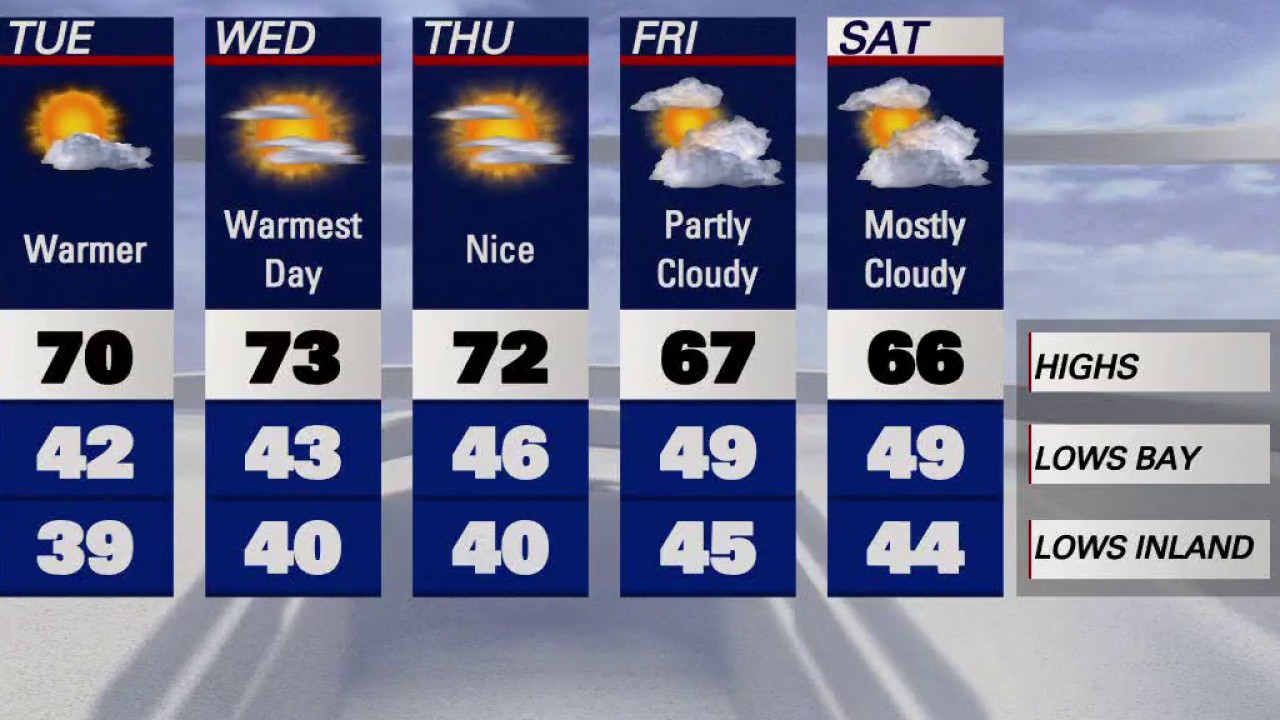
Cooling begins
The mild to warm pattern will begin to fade. Your Friday forecast features cooler temperatures. High clouds will also move across our skies. Highs should range from the mid 60s to the low 70s. Shower chances, favoring the North Bay, are still in the Sunday afternoon - evening forecast. Have a great weekend! -Mark
The mild to warm pattern will begin to fade. Your Friday forecast features cooler temperatures. High clouds will also move across our skies. Highs should range from the mid 60s to the low 70s. Shower chances, favoring the North Bay, are still in the Sunday afternoon - evening forecast. Have a great weekend! -Mark


Wildfire smoke pollution linked to more than 24K deaths a year, study finds
Chronic exposure to pollution from wildfires has been linked to tens of thousands of deaths annually in the United States, according to a new study.
Chronic exposure to pollution from wildfires has been linked to tens of thousands of deaths annually in the United States, according to a new study.


Hazy skies, mild and warm
Today will be mild to warm with hazy skies.
Today will be mild to warm with hazy skies.


Mild to warm
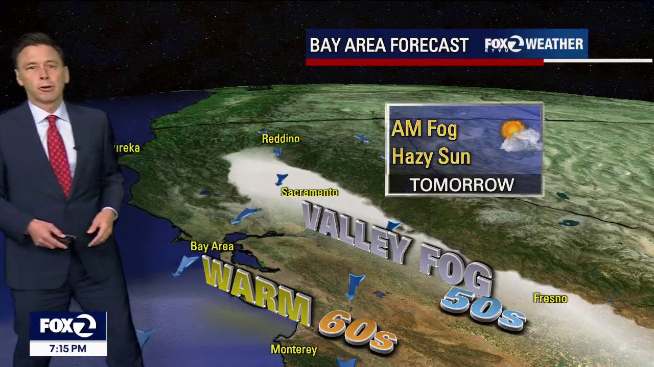
Our warm weather stretch continues. Patchy fog will resurface in the inland valleys Thursday morning. Partly sunny skies are expected later in the day. Highs should range from the mid 60s to the mid 70s. A cooler pattern will lead us to the weekend.
Our warm weather stretch continues. Patchy fog will resurface in the inland valleys Thursday morning. Partly sunny skies are expected later in the day. Highs should range from the mid 60s to the mid 70s. A cooler pattern will lead us to the weekend.


Temperatures make it feel like spring in the Bay Area
Temperatures in several areas around the Bay saw near-record-breaking temperatures on Wednesday afternoon.
Temperatures in several areas around the Bay saw near-record-breaking temperatures on Wednesday afternoon.


Florida freeze: More than 5,000 cold-stunned iguanas collected by Florida wildlife officials
The winter freeze that embraced the sunshine state for several days caused iguanas to fall from trees as the frigid temperatures stunned the invasive species.
The winter freeze that embraced the sunshine state for several days caused iguanas to fall from trees as the frigid temperatures stunned the invasive species.


Warm weather
Today's high could reach near 70 degrees.
Today's high could reach near 70 degrees.


Warm weather
Today's high could reach near 70 degrees.
Today's high could reach near 70 degrees.


Another earthquake swarm in the East Bay
There was another earthquake swarm in the East Bay on Monday. KTVU meteorologist Mark Tamayo breaks it down for us.
There was another earthquake swarm in the East Bay on Monday. KTVU meteorologist Mark Tamayo breaks it down for us.

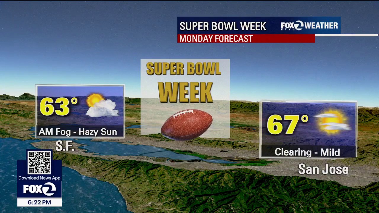
Clear weather conditions leading to Super Bowl LX
Meteorologist Mark Tamayo said weather conditions are expected to remain clear leading up to Super Bowl LX.
Meteorologist Mark Tamayo said weather conditions are expected to remain clear leading up to Super Bowl LX.

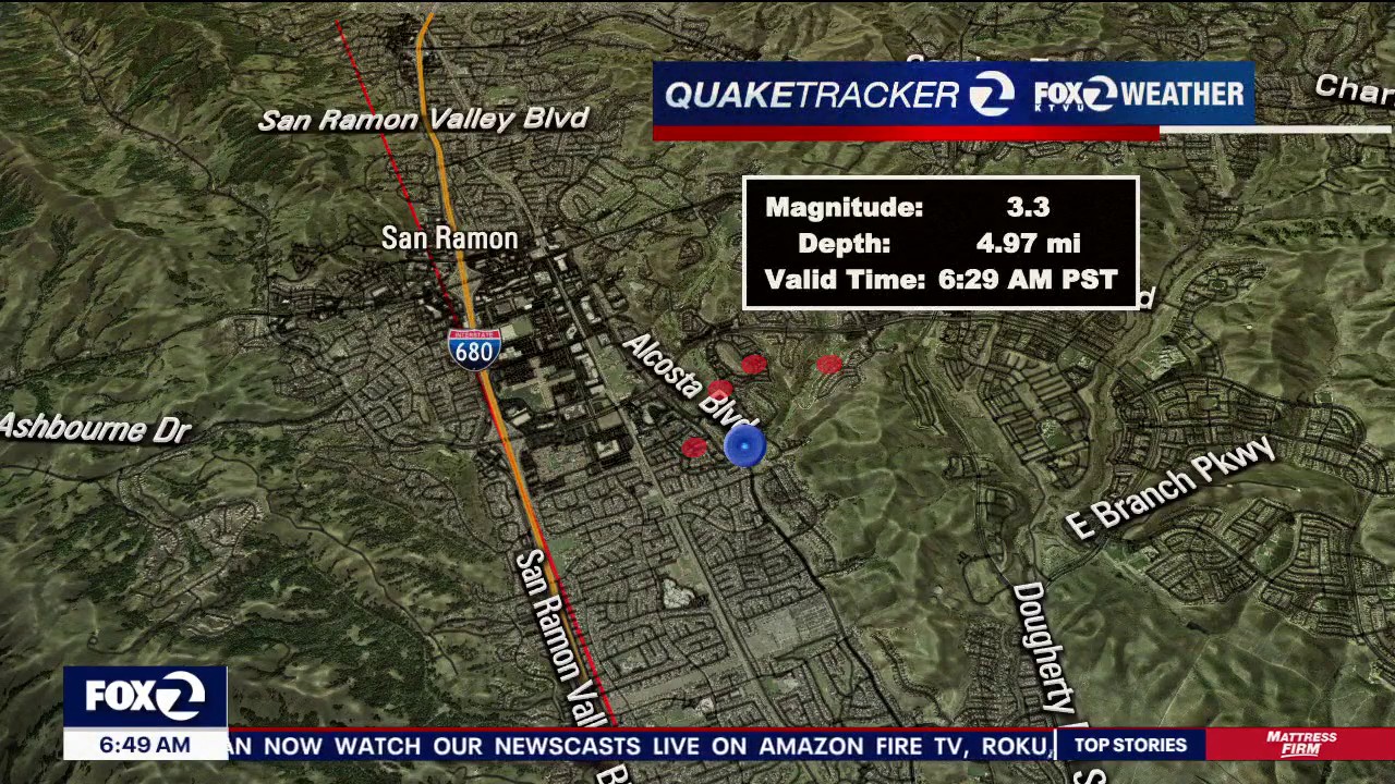
Swarm of earthquakes strike San Ramon, jolting residents
At least 25 moderate and smaller earthquakes hit San Ramon on Monday morning, jolting some residents awake.
At least 25 moderate and smaller earthquakes hit San Ramon on Monday morning, jolting some residents awake.

Quakes strike San Ramon
Two quakes struck San Ramon this morning. Temps will be in the 60s with hazy sun.
Two quakes struck San Ramon this morning. Temps will be in the 60s with hazy sun.

Lots of sunshine and high clouds to continue in the Bay Area
Spring-like warmth and sun is expected to linger in the Bay Area.
Spring-like warmth and sun is expected to linger in the Bay Area.

Early chill and haze blankets the Bay Area
Sunday morning temperatures were cold in the Bay Area, with fog and haze in some areas.
Sunday morning temperatures were cold in the Bay Area, with fog and haze in some areas.


Early weather forecast for Super Bowl LX
Super Bowl week is here — and the Bay Area is about to be on the world stage with Super Bowl LX at Levi’s Stadium in Santa Clara.
Super Bowl week is here — and the Bay Area is about to be on the world stage with Super Bowl LX at Levi’s Stadium in Santa Clara.


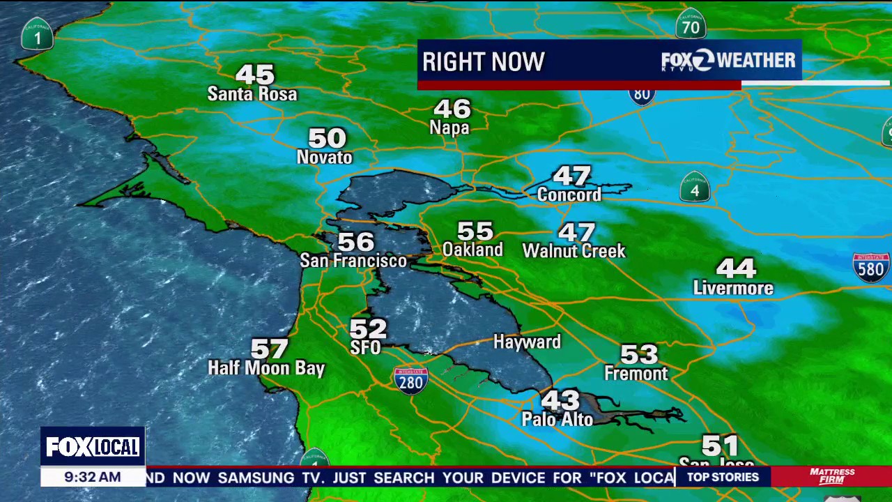
Above average temperatures for the Bay Area
Areas such as San Francisco and San Jose experienced above average temperatures, with the latter of the two nearly reaching a record high.
Areas such as San Francisco and San Jose experienced above average temperatures, with the latter of the two nearly reaching a record high.


3.4-magnitude earthquake strikes near Dublin
The U.S. Geological Survey reported a small earthquake striking just south of Dublin around 10:30 a.m.
The U.S. Geological Survey reported a small earthquake striking just south of Dublin around 10:30 a.m.

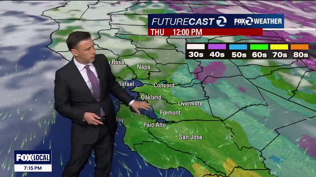
Mild to warm pattern
No big changes to to the forecast. Patchy fog will resurface in the inland valleys Friday morning. Partly skies are expected later in the day. Highs should range from the low 60s to the low 70s. Our dry weather pattern should stick around. Have a great weekend! -Mark
No big changes to to the forecast. Patchy fog will resurface in the inland valleys Friday morning. Partly skies are expected later in the day. Highs should range from the low 60s to the low 70s. Our dry weather pattern should stick around. Have a great weekend! -Mark


Clear, 60s
Today will be clear and in the 60s.
Today will be clear and in the 60s.

Back to dry
After parts of the Bay Area picked up some rain drops late Tuesday, it looks like we now heading back into a dry weather pattern. Fog will resurface in some of the inland valleys Thursday morning. Partly to mostly sunny skies are expected later in the day. Highs should range from the upper 50s to the upper 60s. We are tracking the slight chance of showers in the Sunday pm forecast.
After parts of the Bay Area picked up some rain drops late Tuesday, it looks like we now heading back into a dry weather pattern. Fog will resurface in some of the inland valleys Thursday morning. Partly to mostly sunny skies are expected later in the day. Highs should range from the upper 50s to the upper 60s. We are tracking the slight chance of showers in the Sunday pm forecast.