


Worst Hawaii flooding in decades disrupts farms and produce markets
Hawaii's farming industry is struggling to recover after March storms produced the worst flooding the state has seen in 20 years. The natural disaster has dealt a serious blow to local food supply chains, with state officials urging farmers not to give up.
Hawaii's farming industry is struggling to recover after March storms produced the worst flooding the state has seen in 20 years. The natural disaster has dealt a serious blow to local food supply chains, with state officials urging farmers not to give up.


Fast-moving Sandy Fire in Southern California burns nearly 1,700 acres
An estimated 17,000 Simi Valley residents remain under evacuation orders after the wind-driven Sandy Fire erupted late Monday morning.
An estimated 17,000 Simi Valley residents remain under evacuation orders after the wind-driven Sandy Fire erupted late Monday morning.


California dad pleads guilty to incest involving daughter who died by suicide
A California man pleaded guilty to incest with his 18-year-old daughter, who later died by suicide, prosecutors announced.
A California man pleaded guilty to incest with his 18-year-old daughter, who later died by suicide, prosecutors announced.

New video of deadly UPS plane crash shows engine flying off upon takeoff
The National Transportation Safety Board (NTSB) released new video showing the moment an engine flew off a UPS plane before it crashed.
The National Transportation Safety Board (NTSB) released new video showing the moment an engine flew off a UPS plane before it crashed.

America's best-tasting pizza chain is an old-school favorite, survey finds
The survey found that this pizza chain earned 19.1% of the votes for best-tasting fast-food pizza.
The survey found that this pizza chain earned 19.1% of the votes for best-tasting fast-food pizza.


16-year-old Oakland soccer phenom makes his pro debut
A 16-year-old Oakland high school student, a phenom considered one of California’s best soccer players in his age group, made his pro-soccer debut over the weekend, proudly playing for his hometown.
A 16-year-old Oakland high school student, a phenom considered one of California’s best soccer players in his age group, made his pro-soccer debut over the weekend, proudly playing for his hometown.


San Francisco police arrest three people on theft charges in Chinatown
Three people were arrested in Chinatown on theft-related charges.
Three people were arrested in Chinatown on theft-related charges.
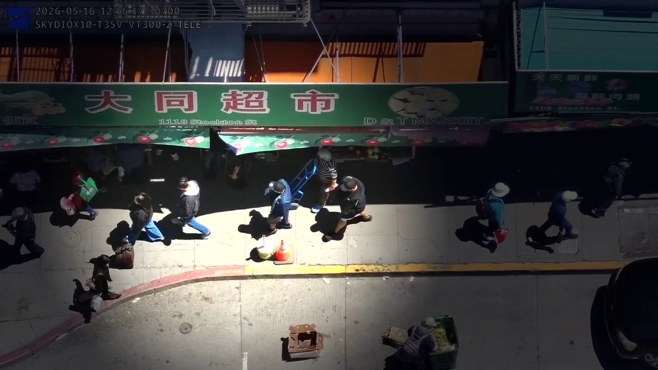
Drone video shows pickpocketing suspects in Chinatown
Drone footage shared from the San Francisco Police Department shows the suspects allegedly pickpocketing in Chinatown.
Drone footage shared from the San Francisco Police Department shows the suspects allegedly pickpocketing in Chinatown.

Heart disease may start in the womb, new study finds
Heart disease during pregnancy may be tied to worse heart health in offspring decades later. Here’s what to know.
Heart disease during pregnancy may be tied to worse heart health in offspring decades later. Here’s what to know.
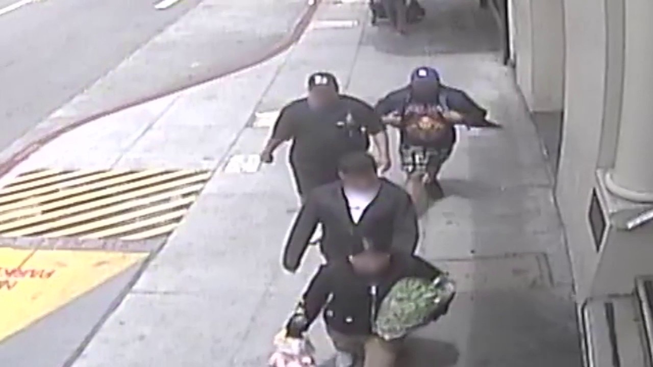
Video; Three suspects arrested in Chinatown theft
San Francisco Police Department arrested three suspects in relation to theft-related charges in Chinatown.
San Francisco Police Department arrested three suspects in relation to theft-related charges in Chinatown.


San Diego mosque shooting: Police were searching for teens before bloodshed
Hours before an attack at a San Diego mosque that killed three men, including a security guard hailed as a hero, police were racing to find the two teenagers who would ultimately be deemed responsible.
Hours before an attack at a San Diego mosque that killed three men, including a security guard hailed as a hero, police were racing to find the two teenagers who would ultimately be deemed responsible.


Photos show San Leandro police chief's Jeep, Chevrolet in alleged hit-and-run
The CHP determined that the chief was at fault for clipping another car's side mirror, but not guilty of a crime.
The CHP determined that the chief was at fault for clipping another car's side mirror, but not guilty of a crime.

House hunting? Data suggests the most affordable cities to buy a home
Homeownership may still be possible – just in different cities. A new study reveals the most affordable U.S. housing markets in 2026.
Homeownership may still be possible – just in different cities. A new study reveals the most affordable U.S. housing markets in 2026.


NFL owners approve Nashville as host of the 2030 Super Bowl
The National Football League voted Tuesday to hold the league's 2030 Super Bowl in Nashville for the first time.
The National Football League voted Tuesday to hold the league's 2030 Super Bowl in Nashville for the first time.

Confronting Islamophobia in the wake of San Diego mosque shooting
Investigators are calling the San Diego mosque shooting a possible hate crime. Professor Farid Hafez, with Georgetown University's Bridge Initiative, talks about the impact of rising Islamophobia and fear within Muslim communities.
Investigators are calling the San Diego mosque shooting a possible hate crime. Professor Farid Hafez, with Georgetown University's Bridge Initiative, talks about the impact of rising Islamophobia and fear within Muslim communities.


Professional women's hockey league expands to San Jose
The Professional Women's Hockey League on Tuesday announced an expansion team to San Jose.
The Professional Women's Hockey League on Tuesday announced an expansion team to San Jose.


TSA Gold+ launching in US airports - What travelers should know
The Transportation Security Administration (TSA) is moving forward with a new airport security initiative called TSA Gold+, a program that could significantly expand the role private companies play in passenger screening operations across the country.
The Transportation Security Administration (TSA) is moving forward with a new airport security initiative called TSA Gold+, a program that could significantly expand the role private companies play in passenger screening operations across the country.


11-year-old girl says she was attacked with air freshener at San Rafael mall
A Marin County father is speaking out and calling for action after his 11-year-old daughter was brutally attacked by an acquaintance outside a local shopping center over the weekend.
A Marin County father is speaking out and calling for action after his 11-year-old daughter was brutally attacked by an acquaintance outside a local shopping center over the weekend.


8-year-old girl dies after San Jose medical emergency, police investigating
An 8-year-old girl who suffered a medical emergency last week at a San Jose home has died, and the medical examiner, police and DA are all trying to figure out how that happened.
An 8-year-old girl who suffered a medical emergency last week at a San Jose home has died, and the medical examiner, police and DA are all trying to figure out how that happened.


San Francisco police searching for murder suspect connected to fatal Sunset shooting
San Francisco police are searching for a murder suspect who shot and killed a man in the city's Sunset District.
San Francisco police are searching for a murder suspect who shot and killed a man in the city's Sunset District.