


Arrested Kentucky DoorDasher said she was spraying ‘spider,’ not food: Sheriff
A Kentucky DoorDasher who is facing multiple felonies told detectives she was pepper spraying a spider - not her customer’s food - when she was seen on doorbell footage spraying an unknown substance.
A Kentucky DoorDasher who is facing multiple felonies told detectives she was pepper spraying a spider - not her customer’s food - when she was seen on doorbell footage spraying an unknown substance.


NTSB investigates gas line strike after explosion injures six near Hayward
Federal investigators are examining a gas line strike that led to a massive explosion in an Ashland neighborhood near Hayward.
Federal investigators are examining a gas line strike that led to a massive explosion in an Ashland neighborhood near Hayward.
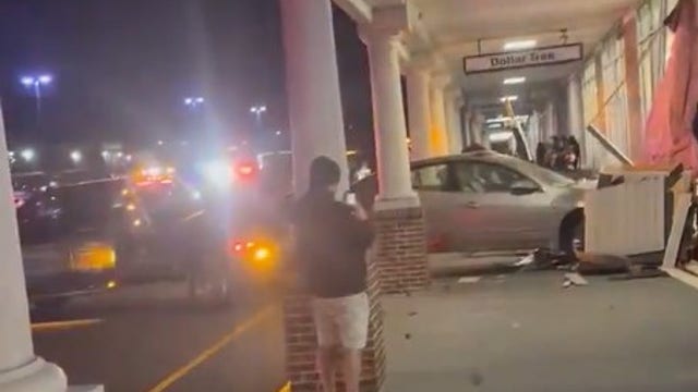

Car smashes into Massachusetts Dollar Tree; Elderly driver suffers minor injuries
An elderly woman was hospitalized with minor injuries after crashing her car into a Dollar Tree store.
An elderly woman was hospitalized with minor injuries after crashing her car into a Dollar Tree store.


Silicosis: Countertops linked to Massachusetts man's diagnosis
A Massachusetts man in his 40s has been diagnosed with silicosis, an incurable lung disease linked to popular kitchen countertops.
A Massachusetts man in his 40s has been diagnosed with silicosis, an incurable lung disease linked to popular kitchen countertops.


Subtle changes today, bigger changes next week
For today, low clouds at the coast, Tule fog inland with cool temperatures for the afternoon, ranging from upper 40s in our valleys to low 60s around the bay. Wet weather is scheduled to return next week.
For today, low clouds at the coast, Tule fog inland with cool temperatures for the afternoon, ranging from upper 40s in our valleys to low 60s around the bay. Wet weather is scheduled to return next week.


Three rescued after boat capsizes in the North Bay
For the second time in the past couple of months, first responders rescued passengers on a boat that overturned in Tomales Bay near Dillon Beach.
For the second time in the past couple of months, first responders rescued passengers on a boat that overturned in Tomales Bay near Dillon Beach.


Organizers and bars getting ready for SantaCon 2025
Last year, the convention got over 8,000 toys, and this year organizers are hoping for more.
Last year, the convention got over 8,000 toys, and this year organizers are hoping for more.


Fog and more fog
Saturday will be day 20 of dense Inland tule fog and 23 days without rain. More of the same on Saturday and Sunday until late Tuesday and Wednesday when light rain enters the Bay area. Until then, temperatures in the 40s and 50s where there is a deck of fog Inland, 50s and 60s elsewhere.
Saturday will be day 20 of dense Inland tule fog and 23 days without rain. More of the same on Saturday and Sunday until late Tuesday and Wednesday when light rain enters the Bay area. Until then, temperatures in the 40s and 50s where there is a deck of fog Inland, 50s and 60s elsewhere.


Roofers create holiday magic for Oakland homeowner
Crews from RK Roofing & Construction are working hard this holiday season to provide a new roof to an Oakland homeowner in need.
Crews from RK Roofing & Construction are working hard this holiday season to provide a new roof to an Oakland homeowner in need.


California mother stabbed while changing baby's diaper at Macy's in New York City
A California woman visiting New York City with her family was stabbed multiple times at Macy’s Herald Square during the holiday shopping rush, officials said.
A California woman visiting New York City with her family was stabbed multiple times at Macy’s Herald Square during the holiday shopping rush, officials said.


California man shocked with $13,000 utility bill
Will received a $13,000 LADWP bill due to incorrect address billing despite notifying the agency of his new address in 2020.
Will received a $13,000 LADWP bill due to incorrect address billing despite notifying the agency of his new address in 2020.


Judge agrees to drop case against ex-San Leandro cop in deadly shooting
The decision comes after Alameda County District Attorney Ursula Jones Dickson said she can't prove beyond a reasonable doubt that the former officer had committed a crime.
The decision comes after Alameda County District Attorney Ursula Jones Dickson said she can't prove beyond a reasonable doubt that the former officer had committed a crime.


French bulldog stolen from owner in SF's Castro District
The Frenchie’s owner said an unknown suspect pulled up to the dog and their coparent in a car and snatched the pet before driving away.
The Frenchie’s owner said an unknown suspect pulled up to the dog and their coparent in a car and snatched the pet before driving away.


SF man convicted for double stabbing that killed 1
A man who in 2023 killed one person and injured another was convicted by a San Francisco jury of murder on Wednesday.
A man who in 2023 killed one person and injured another was convicted by a San Francisco jury of murder on Wednesday.


Crashes, heavy fog snarl traffic on Vasco Road
Several crashes and thick fog were reported Friday afternoon along a major thoroughfare through the Diablo Range, according to the California Highway Patrol.
Several crashes and thick fog were reported Friday afternoon along a major thoroughfare through the Diablo Range, according to the California Highway Patrol.

San Jose family accused of operating brothel network
A San Jose family is suspected of running a network of sex brothels across the Bay Area and trafficking women, according to prosecutors.
A San Jose family is suspected of running a network of sex brothels across the Bay Area and trafficking women, according to prosecutors.


Nasal spray recalled due to possible mold, microbial contamination
ReBoost Nasal Spray, sold nationwide, has been recalled due to potential mold and microbial contamination. Here’s what we know.
ReBoost Nasal Spray, sold nationwide, has been recalled due to potential mold and microbial contamination. Here’s what we know.
Viral video shows DoorDash driver spraying customer's food order during delivery
Police are investigating after the customer experienced burning sensations while eating.
Police are investigating after the customer experienced burning sensations while eating.


Shark bites surfer off Sonoma County coast
A surfer was bitten by a shark Friday on the Sonoma County coast, authorities said.
A surfer was bitten by a shark Friday on the Sonoma County coast, authorities said.


3-alarm fire rips through Tenderloin apartment building, displacing 45
San Francisco firefighters on Friday contained a three-alarm fire that tore through an apartment building in the city's Tenderloin neighborhood, which displaced 45 residents.
San Francisco firefighters on Friday contained a three-alarm fire that tore through an apartment building in the city's Tenderloin neighborhood, which displaced 45 residents.